SPARTAK KABARDINO-BALKAR COUNCIL DOSAAF
Report on the First Ascent via the Western Counterfort of Peak XIV Congress of Komsomol
(approximately 4A category of difficulty)
Central Caucasus
Team coach — Candidate Master of Sports of the USSR Yu.A. Ivanov
Team captain — 1st sports category V.N. Li
Nalchik
September 2–4, 1978
Description of the First Ascent via the Western Counterfort of Peak XIV Congress of Komsomol (Route 4A category of difficulty, September 3–4, 1978)
Sakashil — the right (orographic) lateral gorge of the Baksan valley, is located east of the town Tyrnyauz.
Above the upper reaches of the Sakashil river rises the eponymous peak. The northern ridge of the Sakashil peak, dividing the upper reaches of the Sakashil gorge, ends at the peak named after the XIV Congress of Komsomol.
Photo #1. From the town of Tyrnyauz, move up the road, then along the trail of the Sakashil gorge.
Cross the Kayarta river via the suspension bridge, and after 150–170 m, cross the Sakashil river.
Here, the trail steeply ascends to the "upper koshs".
Near the gardens, you need to turn off the main trail to the right and descend along the trail to the "lower kosh" by the river.
At the kosh, cross to the right bank and follow the trail up and to the left to the "upper koshs".
Upon reaching the grassy ridge of Peak Yunost, proceed up along the Sakashil gorge until it makes a sharp turn to the right. After proceeding a bit up the ridge, behind its turn, descend into the Khunalychat gorge.
Along the stream bank of the Khunalychat gorge, ascend to the upper meadow "football field".
The initial bivouac is on the meadow. It takes 4–5 hours from the town. From the meadow, ascend along the stream bed in the direction of the Western counterfort. It takes 1–1.5 hours from the bivouac.
To the right of the light-brown rock face (Photo #2) on the Western counterfort of the peak, via the internal angle (6) straight up — the beginning of the route (marked by a control cairn). Photo #3. After 40 m of difficult climbing (steepness 80°, ladders!), we emerge onto a large talus shelf-terrace (I). Along the shelf (50–60 m), and then via simple rocks (20 m), we approach under the reddish overhanging rocks (to the right on the rocks, black streaks). Photo #4. From here, up via the chimney (2) 35–40 m with a small number of smooth holds — ascent using wedging. Protection is via pitons (channel pitons, wooden wedges). Photo #5.
Above the chimney, there is a small platform. Further, via a weakly expressed internal angle, exit onto the ridge (30–35 m). From the shelf-terrace, it takes 2 hours.
Along the ridge (10 m), exit onto an inclined slab (3) with a steepness of 30–35°. Along the slab (30 m, petal pitons), and then via the internal angle (Photo #6), formed by the slab and the wall with a steepness of 90–95°, left and up 40 m under a twenty-meter wall. Up the wall to a platform (5 m of very difficult climbing, overhanging section, ladders).
On the platform, there is a spot for an overnight stay, 2nd control cairn. From the 1st control cairn, it takes 7–8.5 hours.
From the control cairn straight up the wall with a steepness of 60–70° Photo #7 (50–60 m, thorough piton protection), sticking to its right part, we emerge onto a small ledge. Further straight up 30 m via rocks of medium difficulty, we exit onto the ridge. Along the ridge 60 m under a small wall (8 m), bypass it on the left, and further along the rocks of the ridge with medium difficulty, we reach the summit. From the 2nd control cairn, it takes 2–2.5 hours.
Descent via R10–R3 ridge on route 2B category of difficulty.
Note: The description should be considered in conjunction with Fig. 1.
Fig. 1.
4 — Peak XIV Congress of Komsomol, 3465 m.
Δ — control cairn
— — — visible path
— — invisible path
1 — large talus shelf-terrace
2 — chimney (35 m)
3 — inclined slab (35°, 30 m)
4 — oblique internal angle (40 m)
5 — wall (60–70°, 50–60 m)
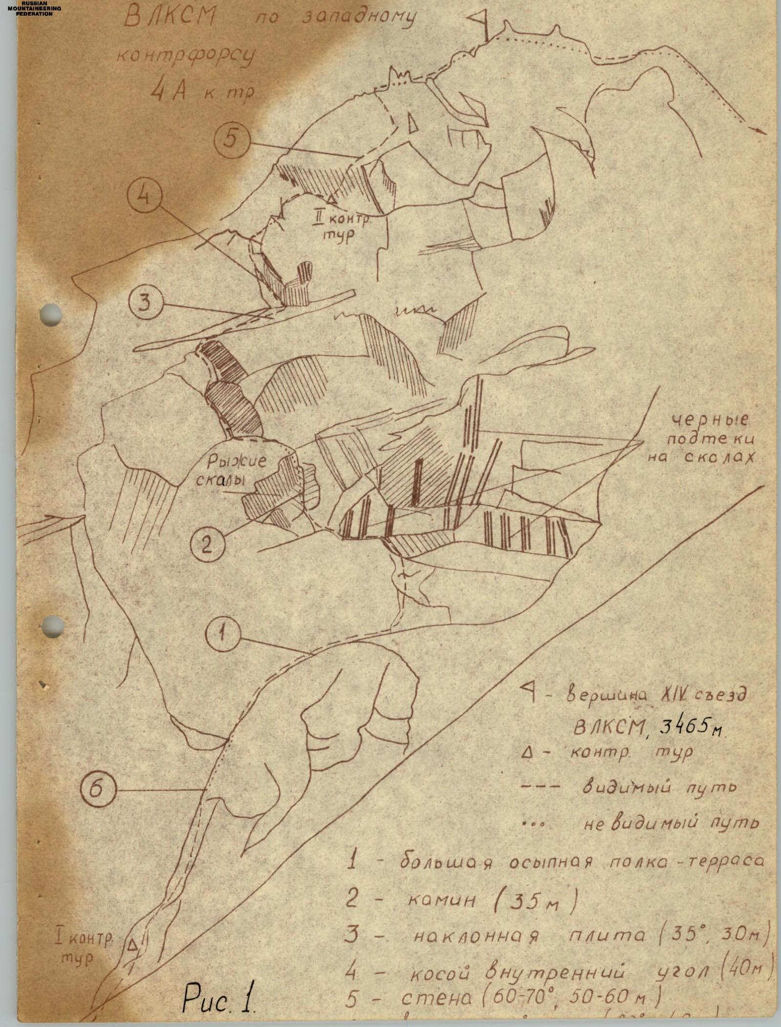

Photo 1
CHARACTERISTICS TABLE OF THE ASCENT ROUTE TO PEAK XIV CONGRESS OF KOMSOMOL
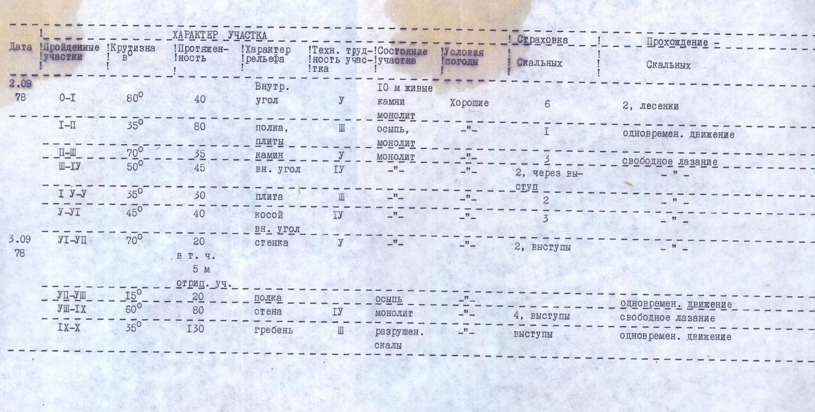
Photo 2

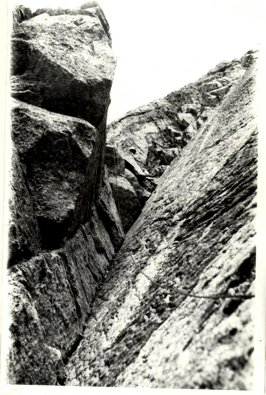
Photo 3