- Summit, its height — peak XIV съезда ВЛКСМ, 3465 m
- Ascent route — south-eastern edge from the cirque of Sakashil glacier.
- Proposed complexity category — 3B
- Route characteristic: rocky, height difference — 350 m, average steepness 55°.
- Pitons driven: rock — II pcs.
- Number of travel hours: a) Tyrnyauz — bivouac — 6 h; b) bivouac — summit — 6 h
- Number of overnight stays — one overnight stay at a bivouac at the Small Lake on the terminal moraine of Sakashil glacier.
- Leader: EFREMOV Vladimir Vasilievich, 1st sports category
Participants:
- Galyamov Shagimul Magadovich — 1st sports category
- Rozin Igor Leonidovich — 2nd sports category
- Erohin Ivan Dmitrievich — 2nd sports category
Observers:
- Parygin A.N.
- Grebennikova N.A.
- Date of departure on the route — May 23, 1980 and return — May 24, 1980
SIGNATURE:
Information about reconnaissance
Group members made ascents to peak XIV съезда ВЛКСМ via the southwestern ridge 2B category and via the northeastern ridge 3B category from a bivouac at the Small Lake from April 30 to May 3, 1980.
At that time, the following were done:
- the route of ascent to the summit from the south was planned,
- photographs of the route were taken directly from the bivouac,
- photographs were taken in profile from the lateral moraine of Sakashil glacier.
The route is purely rocky, was in good condition, and it was decided to make an ascent in the near future. The route is fully visible from the bivouac.
Tactics for the ascent
The approach to the route is not new; the ascent was made with an overnight stay at the Small Lake on the terminal moraine of Sakashil glacier, from where routes to peak XIV съезда ВЛКСМ via the southwestern and northeastern ridges start, as well as all routes to v. Sakashil.
From Tyrnyauz — 6 h.
The approaches do not include dangerous or technically complex sections and do not require any special equipment.
From the overnight stay to the start of the route is 20–30 min of ascent on medium scree (at the beginning of the season — on a snowy slope of medium steepness).
The ascent was planned only in good weather; in case of bad weather, the group had a reserve day — May 25. Two observers were at the overnight stay, visually monitoring the group and having communication with the KSP of the Elbrus region using the "Nedra" radio station.
The route does not include avalanche- and rockfall-prone sections, has sufficient sections for group gathering and bivouac organization.
The group departed on the route at 5:00, was at the summit at 11:30, and descended to the bivouac via the southwestern ridge at 14:00, from where they returned to Tyrnyauz on the same day.
The descent from the summit was made on a well-studied route of 2B category, also leading to the overnight stay at the Small Lake.
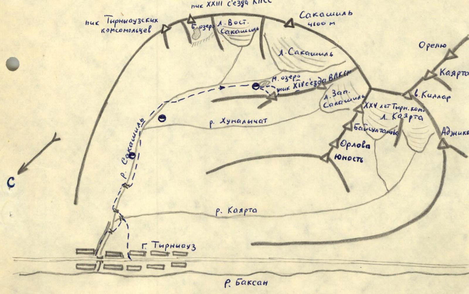
Description of approaches to the route
From the city of Tyrnyauz, ascend along the road on the left (in the direction of travel) bank of the Sakashil river. Higher up, cross to the right side of the gorge via a bridge and approach the Kayarta river. (An alternative — from the stadium, ascend along a trail to the saddle of a spur dividing the Baksan and Sakashil gorges, and from the saddle, traverse along a trail on a forested slope to the confluence of the Sakashil and Kayarta rivers).
Here, cross the Kayarta river via a bridge, and after 150–170 m — also the Sakashil river, to its left bank. From here, the trail steeply ascends along the canyon of the river. Near the gardens, one should turn off the main trail to the right and descend along a trail to the "lower koshu" by the river. Here, cross to the right bank of Sakashil via a bridge and move along a trail on the right bank.
Before reaching the Hunalyчат river, cross to the left bank of Sakashil river. Before a steep morainic ascent of the gorge, cross again to the right bank of Sakashil and exit to the Small Lake, located near the tongue of Sakashil glacier.
From the city of Tyrnyauz — 6–8 h.
Description of the route and explanation for the table
From the overnight stay, descend from the moraine and approach via scree to the lowest rocky outcrop of the southern wall of the summit, isolated on both sides by narrow couloirs.
Ascent of 100–120 m via the left steep snowy couloir, then via simple rocks on its right side to the summit of the rocky outcrop, under the steep ascent of the southern edge (section 1).
Further, along ledges and steep but simple rocks, bypass to the right the lower ascent (40 m) and exit to a sharp rocky ridge under the second steep rocky ascent (section 2). Via rocks of medium difficulty of ascent (pitons for protection), ascend 40 m to a shoulder (section 3). From the shoulder, 40 m up-left via steep large-block rocks, then under overhanging rocks, traverse left 15 m along a simple ledge to the key section of the route (sections 4–5).
The key section is a 5-meter difficult inner corner with a small number of holds (pitons for protection, wedges) (section 6).
From the inner corner, exit to a simple couloir, 5 m up-right via the couloir — a control cairn.
Further, via simple rocks, 60 m up to the summit tower (section 7), 30 m up-right via steep large-block rocks, then 40 m up-left via a couloir and rocks on its right side to the summit (section 8). From the bivouac — 6–7 h. Descent from the summit via the southwestern ridge.
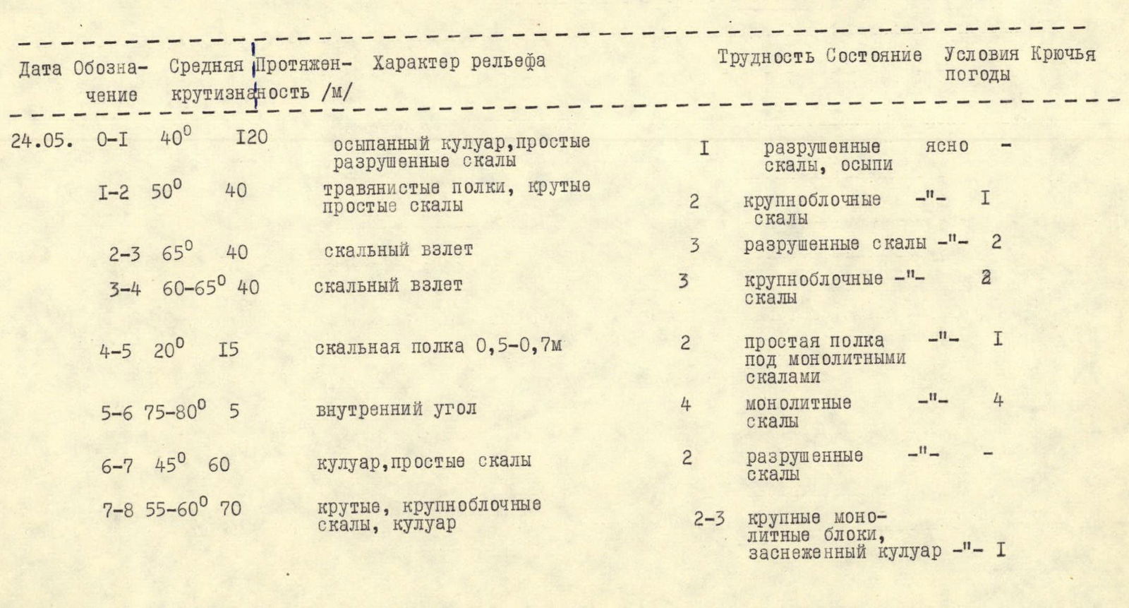
Table № 1
| Date | Designation | Average steepness | Length, m | Relief character | Difficulty | Condition | Weather conditions | Pitons |
|---|---|---|---|---|---|---|---|---|
| 24.05. | R0–R1 | 40° | 120 | scree-filled couloir, simple destroyed rocks | 1 | destroyed rocks, scree | clear | — |
| R1–R2 | 50° | 40 | grassy ledges, steep simple rocks | 2 | large-block rocks | «–» | 1 | |
| R2–R3 | 65° | 40 | rocky ascent | 3 | destroyed rocks | «–» | 2 | |
| R3–R4 | 60–65° | 40 | rocky ascent | 3 | large-block rocks | «–» | 2 | |
| R4–R5 | 20° | 15 | rocky ledge 0.5–0.7 m | 2 | simple ledge under monolithic rocks | «–» | 1 | |
| R5–R6 | 75–80° | 5 | inner corner | 4 | monolithic rocks | «–» | 4 | |
| R6–R7 | 45° | 60 | couloir, simple rocks | 2 | destroyed rocks | «–» | — | |
| R7–R8 | 55–60° | 70 | steep, large-block rocks, couloir | 2–3 | large monolithic blocks, snowy couloir | «–» | 1 |
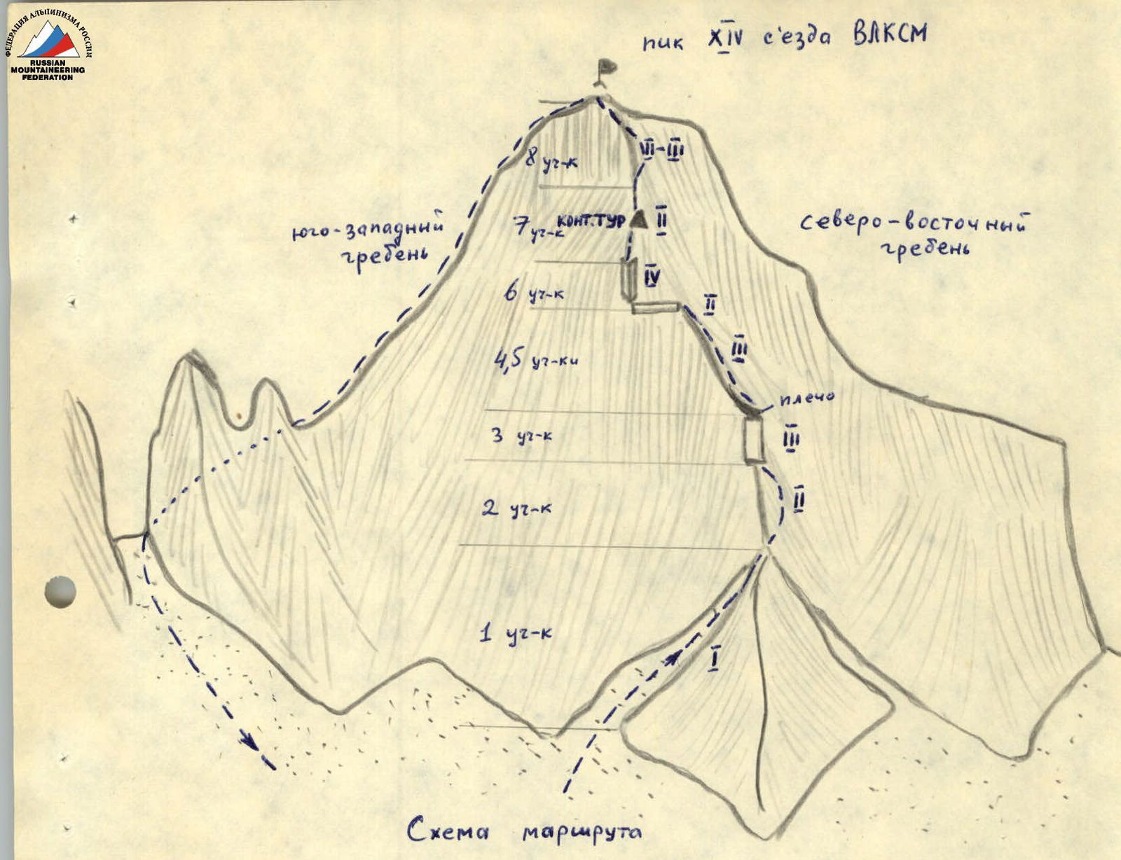
Scheme 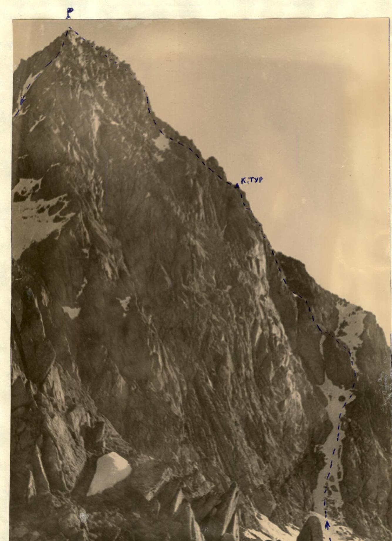
View of the southern slope of peak XIV съезда ВЛКСМ from the moraine of Sakashil glacier 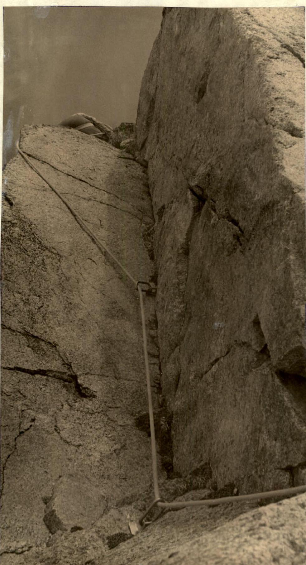
On the key section of the route (section 6)