Ascent Passport
- ASCENT CLASS: rock
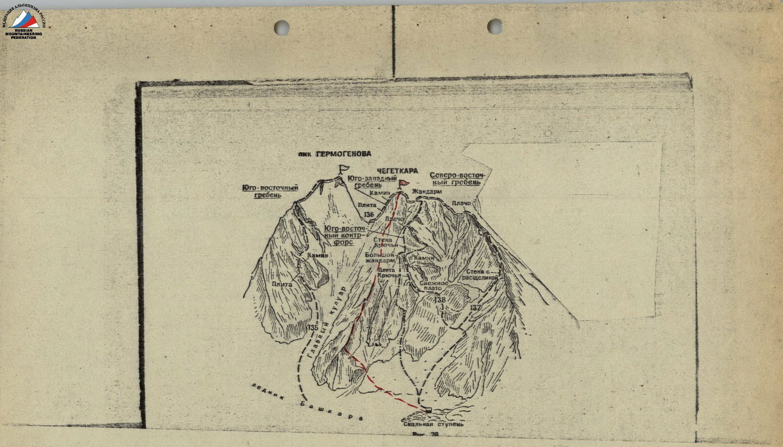
- ASCENT AREA: Main Caucasus Range, Northern spur of Ullukara.
- ASCENT ROUTE WITH INDICATION OF PEAKS AND THEIR HEIGHTS: v. Cheget-Kara – 3667 m, via the left Southeast buttress.
- PROPOSED DIFFICULTY CATEGORY: 4A cat. diff.
- ROUTE CHARACTERISTICS: height difference: 850–900 m, average slope – 45°, length of complex section – 240 m.
- NUMBER OF PITO NS INSTALLED: rock – 12, ice –
- NUMBER OF TRAVELING HOURS: 7 hours.
- NUMBER OF OVERNIGHT STAYS: –
- FULL NAME OF LEADER, PARTICIPANTS, AND THEIR QUALIFICATION:
- Chegel V.I. – leader CMS;
- Stadnik V.F. – participant CMS;
- Yankovsky V.I. – "–" CMS;
- Khoroshilov A.A. – "–" 1st sports category;
- Panasyuk I.O. – "–" 1st sports category.
- TEAM COACH: KOROLENKO N.Ya.
- DATE OF DEPARTURE ON THE ROUTE AND RETURN: July 2, 1977.
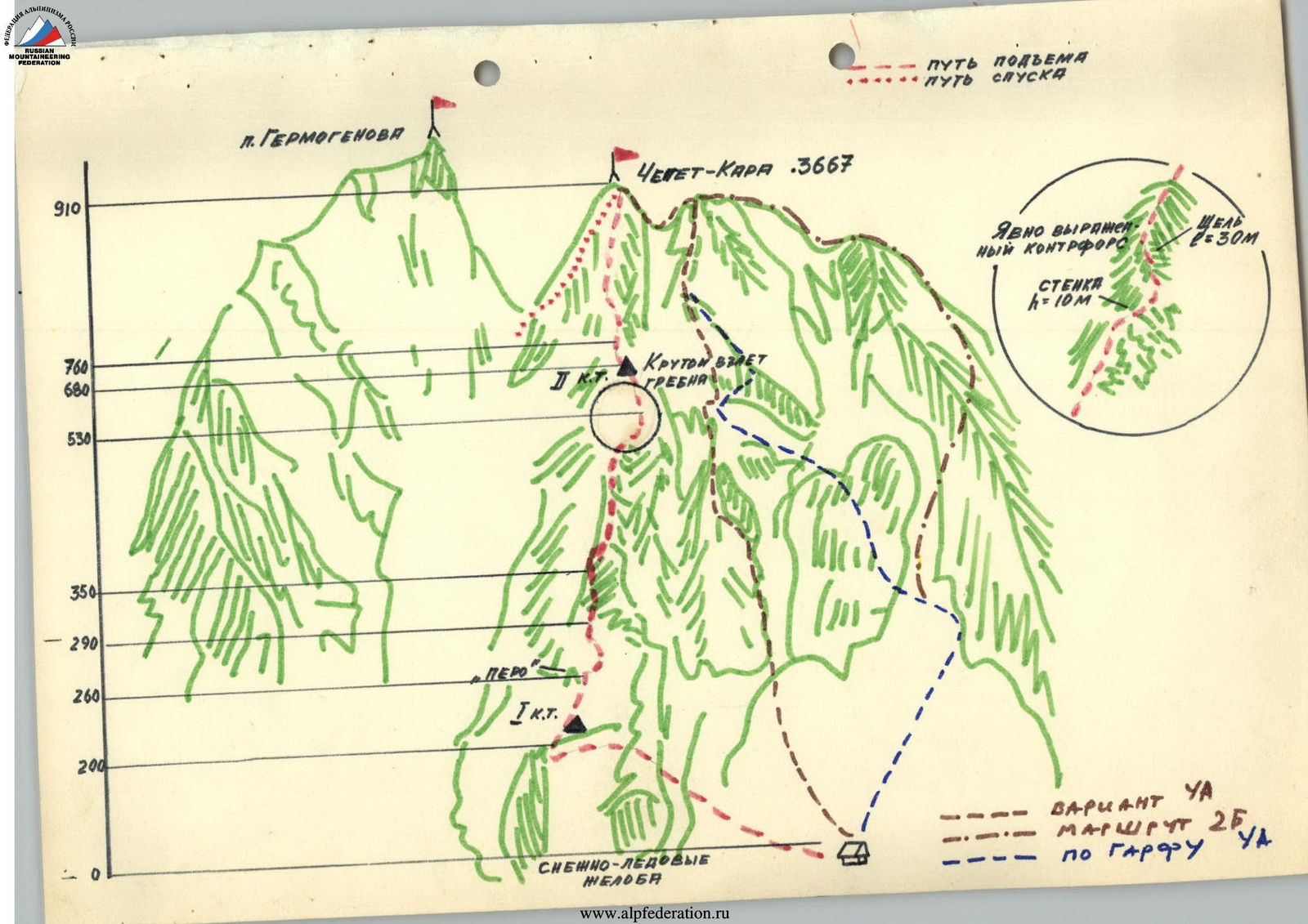
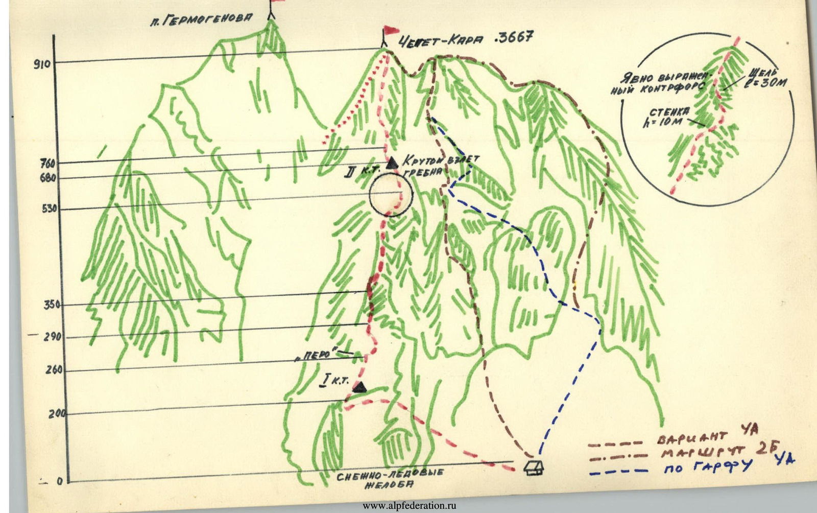
— — — First ascent route 138 — — — Garda route 4A cat. diff. 137 — — — Route 2B cat. diff.
Route Description
The peak Cheget-Kara via the left Southeast buttress.
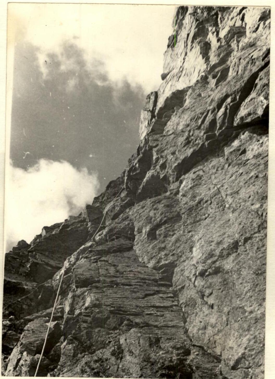
From the "Jantugan" alpine camp, ascend along the Adylsu gorge trail, then cross to the right bank of the Adyl-Su River via a natural stone bridge and follow the trail along the river to the "Green Hotel" clearing. From there, turn right and ascend along the trail to the left-bank moraine of the Bashkara glacier. From the moraine, move right onto the Bashkarinsky glacier. Cross it to the right and reach the right side of the rocky step located under the southern slopes of Cheget-Kara. To the left of the rocky step is the icefall of the Bashkara glacier. From the glacier, ascend a grassy and scree slope to the brow of the step, then via the "ram's foreheads" to the scree under the rocky step. On the scree – bivouac.
From the "Jantugan" alpine camp 3–4 hours. From the overnight stay, ascend a snowy couloir slope to the left upwards 300 m (average slope 30–40°), crossing three ice-snow gullies. Then 80 m along a slope with a slope of 45–50°. Further – a twelve-meter steep snowy ascent, which leads to the rocks.
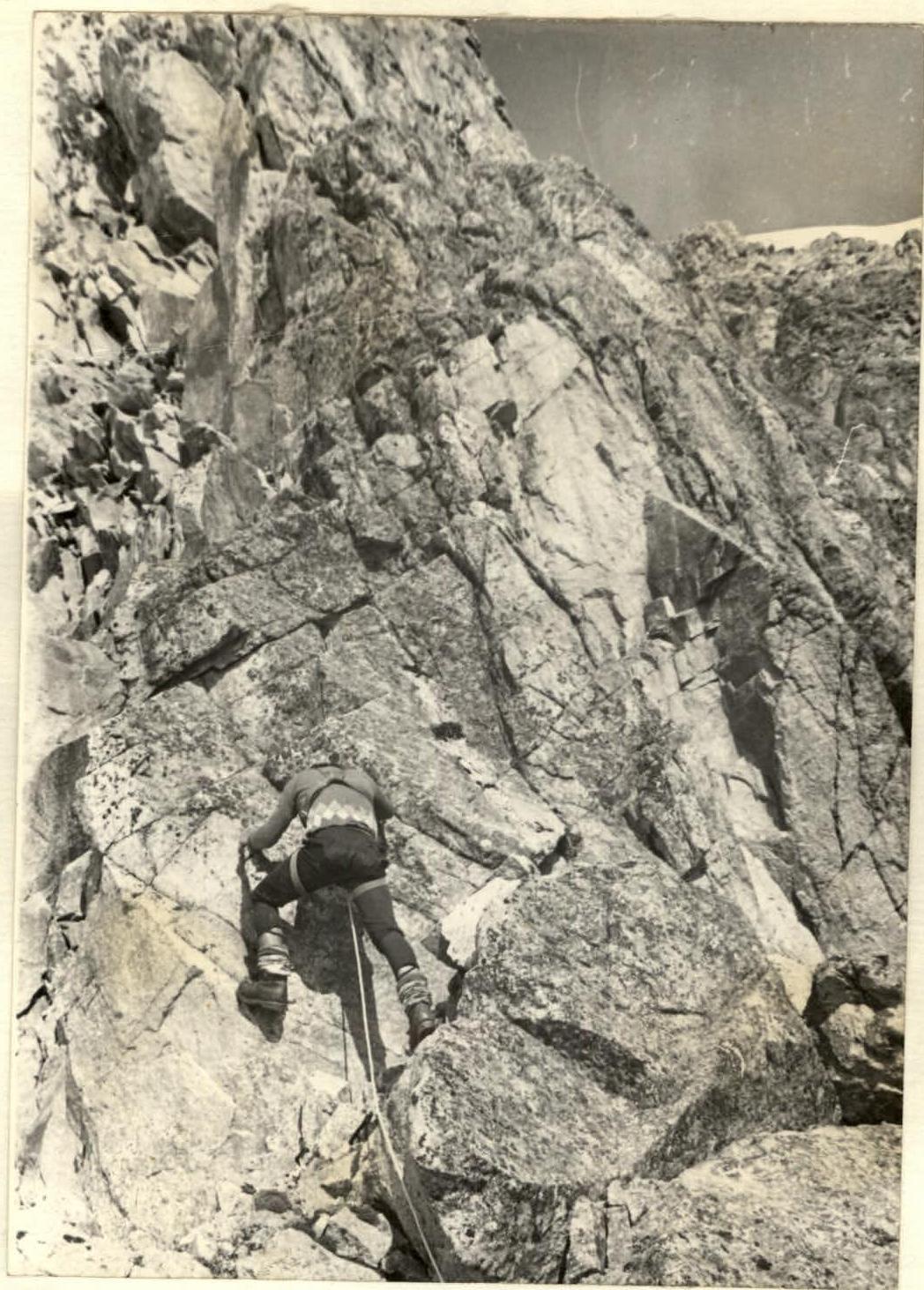
Along the internal angle 25 m (50°) we exit onto the left Southeast buttress. At the exit to the buttress – R1 control point.
Further along the ridge (smooth slabs 30°) 60 m – exit under the feather, which is bypassed on the right via a six-meter wall (pitons). Then along the ridge 30 m to a rusty overhanging rock, which is bypassed on the right via a 20 m wall with an exit onto a snow-rock saddle. Along the saddle – approach to a rocky wall (destroyed rocks with a slope of 60–65° and height 60 m). The wall ends with a rocky ascent, which is bypassed on the left via a ledge, and then to the right upwards along a smooth wall 5 m – exit onto the ridge. Along the ridge – approach to the second feather, which is bypassed on the left, and along the internal angle 40 m with a slope of 70° – exit onto the ridge (pitons). Along the ridge and destroyed rocks – approach to a smooth wall 6 m (80°). Along the wall to the right-upwards, and then along the internal angle to the left-upwards – onto the ridge, along which we exit onto a snowy saddle (length of section 120 m).
Along the snowy saddle – approach under a ten-meter rocky wall, which is climbed via the internal angle and steep slabs (pitons) and leads to a pronounced internal angle. Along the internal angle – 20 m – to overhanging rocks. Under the rocks, via a crack, exit to the right onto the lateral wall of the ridge (diverting to the right into the couloir is not recommended – rockfall hazard).
Along the wall 40 m (70°) to the left-upwards – exit onto the ridge (pitons).
The ridge is a series of steep ascents up to 10 m. Total length of section – 150 m. Before the pre-summit ridge ascent (length 100 m) – R2 control point. Further – exit onto the pre-summit section of the ridge with a slope of 30–35°. Before exiting onto the summit – a chimney (pitons), which leads onto a snowy gentle ridge leading to the summit.
Descent via route 2B cat. diff.
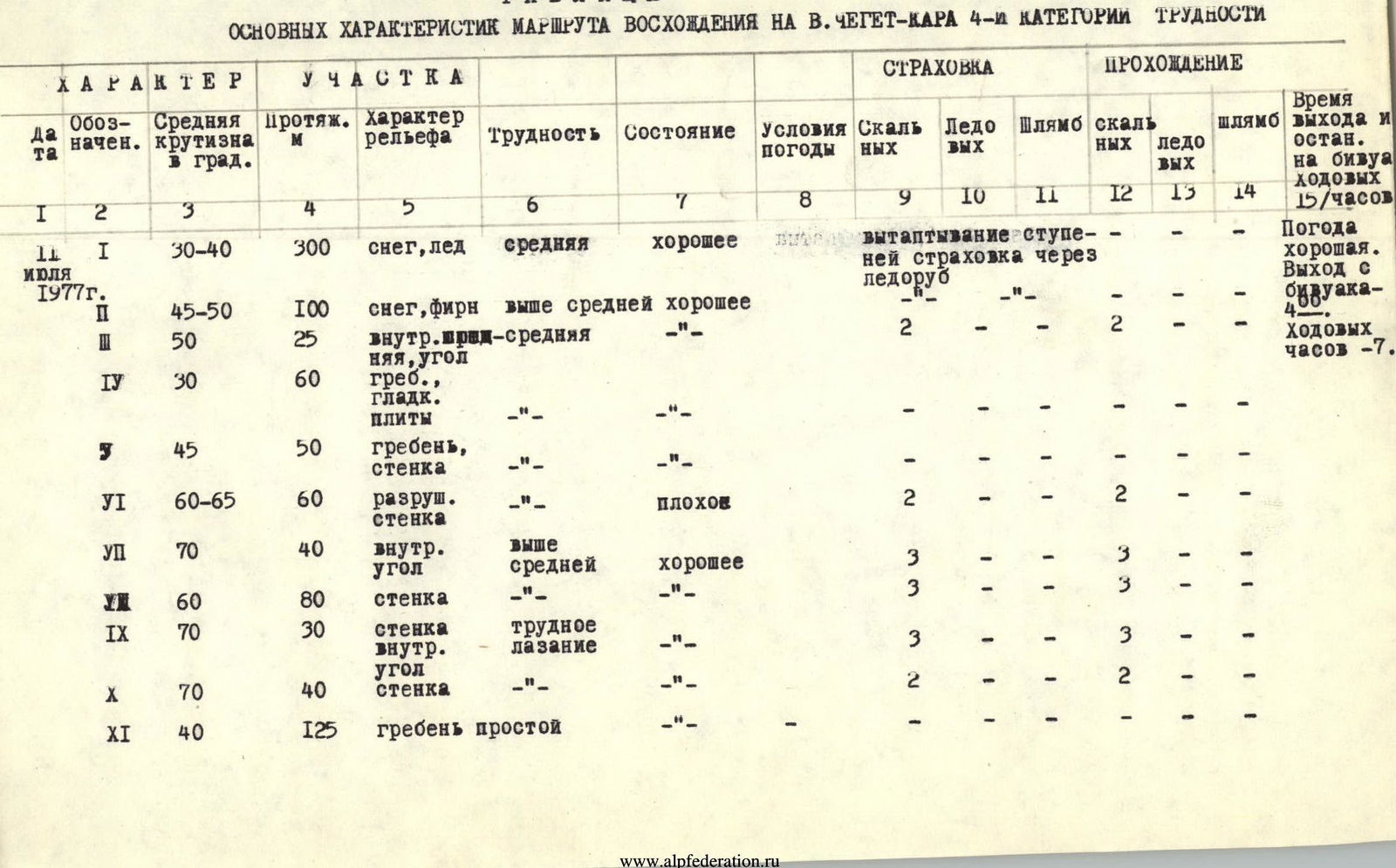
TABLE OF MAIN CHARACTERISTICS OF THE ASCENT ROUTE TO V. CHEGET-KARA 4th DIFFICULTY CATEGORY
| Section # | Avg. slope, ° | Length, m | Terrain characteristics | Difficulty | Condition | Weather conditions | Rock insurance | Ice insurance | Belay insurance | Rock passage | Ice passage | Passage insurance | Time of exit and rest |
|---|---|---|---|---|---|---|---|---|---|---|---|---|---|
| R1 | 30–40 | 300 | snow, ice | medium | good | stepping insurance with ice axe | Weather is good. Exit from bivouac – 4:00. Traveling hours – 7. | ||||||
| R2 | 45–50 | 100 | snow, firn | above medium | good | 2 | 2 | ||||||
| R3 | 50 | 25 | internal angle | medium | –"– | 2 | 2 | ||||||
| R4 | 30 | 60 | ridge, smooth slabs | –"– | –"– | ||||||||
| R5 | 45 | 50 | ridge, wall | –"– | –"– | ||||||||
| R6 | 60–65 | 60 | destroyed wall | –"– | bad | 2 | 2 | ||||||
| R7 | 70 | 40 | internal angle | above medium | good | 3 | 3 | ||||||
| R8 | 60 | 80 | wall | –"– | –"– | 3 | 3 | ||||||
| R9 | 70 | 30 | wall internal angle | difficult climbing | –"– | 3 | 3 | ||||||
| R10 | 70 | 40 | wall | –"– | –"– | 2 | 2 | ||||||
| R11 | 40 | 125 | simple ridge | –"– | –"– |
SECTION R1 OF THE ROUTE
SECTION R9 OF THE ROUTE