Starikov Gennadiy, Moscow (author's photo) Trapezia 2A. Ascent passport.
- Region — Caucasus, Adylsu gorge. (tab. – 2008, p. 42, item 171) Peak name — Trapezia (3697), S slope and W ridge.
- 2A cat. of difficulty (first ascent)
- Route type — rock.
- Route elevation gain from the glacier — 600 m
Route length — 1200 m
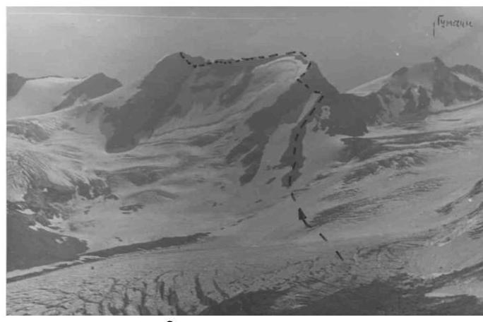
- view from the Adylsu gorge
- view from the glacier
- Total pitons used on the route: rock pitons — 5 pcs.
- Travel time from the bivouac at Zelyonaya Gostinitsa to the summit — 7 hours, steep descent to the eastern saddle with Chotchat peak, then left to the glacier, bypassing 1-2 bergschrunds (belay!), (it's possible to descend from this saddle to the right to Gumači col and further). See five photos.
- Sports team: leader Naydovich B.V. — Candidate Master of Sports, instructor; Starikov G.A. — 1st sports category, instructor; Sinelshchikov G. — 2nd sports category.

- from the saddle to the 3rd ridge

- ridge to Trapezia peak
- Coach: Barov K.A. — Master of Sports, Honored Coach of Ukraine.
- Departure to the route and return: August 6, 1974.
- Organization — All-Union School of Instructors at "Elbrus" alpine camp.
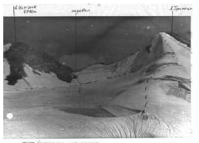
- view of the descent from the saddle from Chotchat peak
Recommendations:
- have 6-7 rock pitons.
Note: the route itself is logical. The hazardous section is right before the summit — descending from the ridge to the left onto the northern slope for 15-20 meters, traversing under the summit (an ice piton will be encountered, hammered into the rock).
See photo 2. Along the talus ridge, ascend to the rocky saddle (control cairn 1). From the saddle, left and up 100 m along the ridge. It's better to bypass a small wall on the way to the left. Exit to the main ridge to the left to a yellow rounded internal corner-couloir 25 m. Further along the western ridge, the path leads to the southern summit — control cairn 2.
The path goes along the destroyed rocks of the ridge to the 1st pinnacle, which is bypassed along a ledge (30 m) with belay through a protrusion. Then along the sharp ridge 15 m under the 2nd pinnacle, which is bypassed to the left. At first, you need to descend down along an inclined ledge to the snow-ice slope. Further — along the boundary of snow and rocks to the beginning of the "Russet" ledge, which exits diagonally to the grey-white rocks of the summit tower.
Movement with alternating belay through protrusions. Grey-white rocks are overcome upwards until exiting onto the main ridge. From here, bypassing the summit tower, to the right along the ledges — exit to the summit.