
peak Sarykolbashi-tersak (3776) Route: via the southern ridge Category complexity — 1B cat. (rocky) Leader: D. Strelchuk Central Caucasus, Prielbrusye, Terskol gorge Section in KMGV — 2.4. E-mail — ZHUR58@RAMBLER.RU
Report
On the first ascent of the climbing route to the peak Sarykolbashi-tersak (3776) "via the southern ridge 2A cat. (rocky)". At the mountaineering event of the Higher Mountain School of the FAR "School of Instructors of Mountain Training of the Ministry of Defense of the Russian Federation" in 2012.
Region: Kabardino-Balkarian Republic Mountain country: Central Caucasus Gorge: Terskol Ridge: mountain range — southeastern spur of Elbrus "Terskolak — TersakItkolbashi" Peak: Sarykolbashi-tersak (3776 m) Route: via the southern ridge Level of complexity: 1B cat. (rocky) Prepared by: D. Strelchuk, S. Zhuravlev September, 2012
Description of the route
The route "Via the southern ridge" is a typical training and sports rocky route of 2A category, with a full set of natural obstacles corresponding to routes of this level. The route is logical in orientation.
Approach
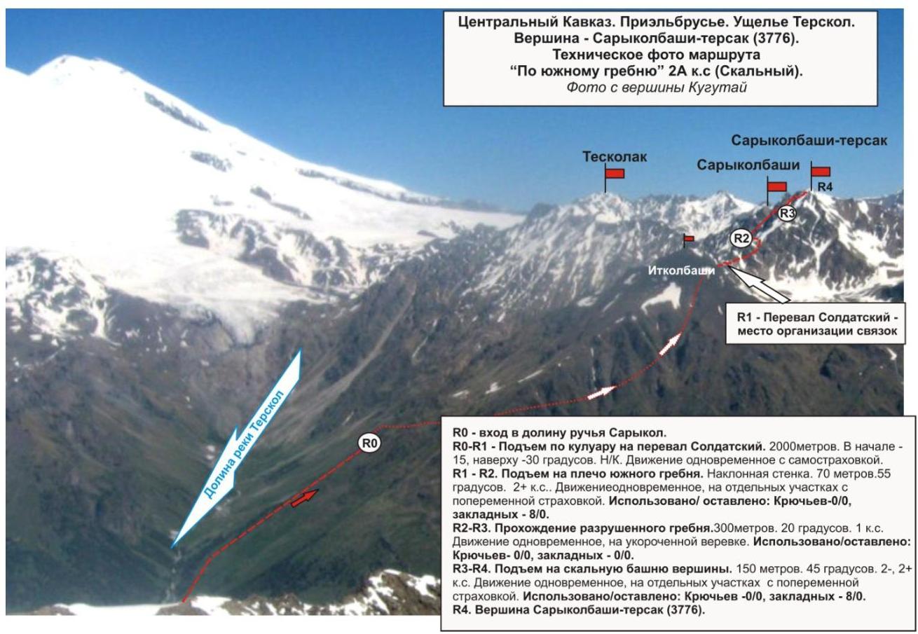
The ascent is made from the village of Terskol. Walk along the dirt road to the cowshed standing near the mouth of the Sarykol stream. Then, along the valley of the Sarykol stream, ascend to the source of the stream, where the watercourse disappears in the talus. This place is the beginning of the technical part of the route.
Technical part
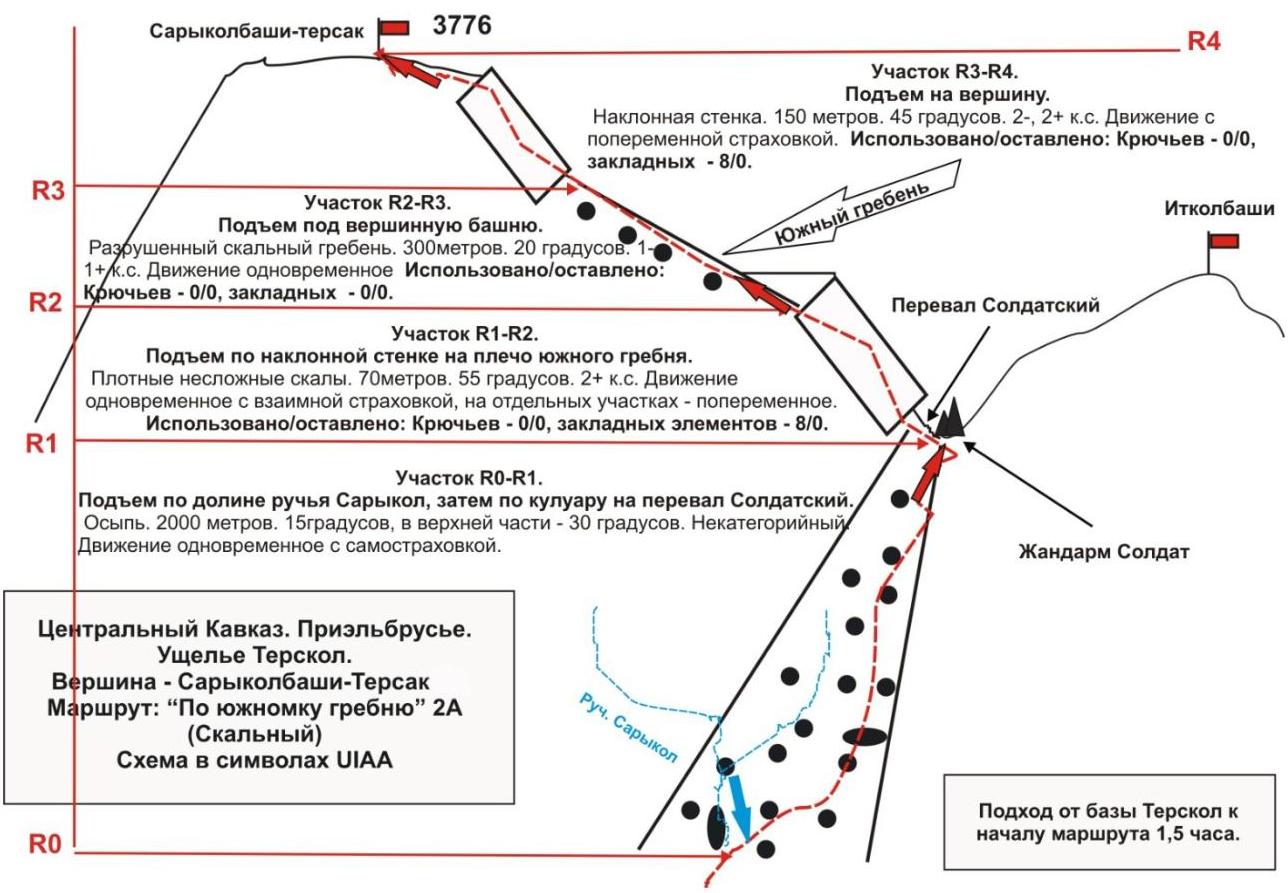
Ascend the talus slope, in the upper part — a wide couloir, to the Soldatsky pass. On the pass, organize a rope team and approach the key section of the route.
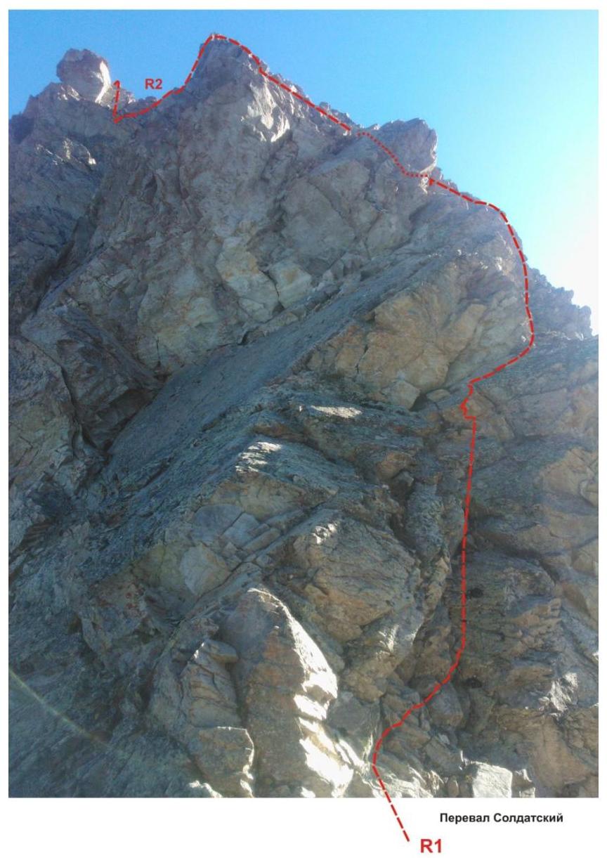
The key to the route is a wall with an abundance of relief, both for climbing and for organizing intermediate belay points.
After passing the wall — exit to the rocky shoulder of the southern ridge. Then:
- a long movement along the rocky destroyed ridge under the summit tower;
- then, along a wall of medium steepness — simple climbing with an ascent to the summit.
The summit is ярко expressed. The cairn is easy to find. Descent from the summit: descent from the summit via the ascent route.
Equipment:
To complete the ascent as part of a sports department of 6 people, the following special equipment is required on the route:
-
personal — standard
-
public:
- rope main 10 mm — 3×50
- hammer rock — 2 pcs.
- hooks rock — 6 pcs.
- ice axe — 1 pc.
- закладные элементы — 6 pcs.
- friends — 6 pcs.
- оттяжки — 16 pcs.
- петли — 10 pcs.
- gas burner
- котелок
Recommendations to the instructor
Due to the accessibility in orientation, the route can be recommended both for training and sports departments (SP-1, 2) and for independent sports groups of разрядники, conducting leadership or training ascents.
Time costs for passing the route for a training and sports department of разрядники of average level of training (SP-1, 2):
- 12–14 hours.
Passport
- Number of section according to KMGV — 2010 — 2.4.
Central Caucasus, mountain region — Prielbrusye, Terskol gorge, southeastern spur of Elbrus
- Name of peak: Sarykolbashi-tersak, height: 3776 m. Route: via the southern ridge
- Category of complexity: 2A cat.
- Character of the route — rocky.
- Height difference of the route: 1376 m
- Length of the route: 2620 m
- Length of sections of the highest category of complexity:
1 cat. — 0 sections — 0 m, 2 cat. — 0 section — 0 m, 3 cat. — 0 sections — 0 m
4 cat. — 0 sections — 0 m, 5 cat. — 0 section — 0 m, 6 cat. — 0 sections — 0 m
- Average steepness: main part of the route — 55°.
whole route — 40°
- Used hooks:
Used in total on the route:
- rock hooks — 0
- закладок — 16
- шлямбурных стационарных — 0
- ИТО — 0
- шлямбурных съёмных — 0
Left "hooks" on the route: total — 0; including шлямбурных — 0.
- Exit to the route — 4:00, October 10, 2012
Exit to the summit — 14:00, October 10, 2012 Return to BL — 19:00, October 10, 2012
- Walking hours of the team: — 10 hours (to the summit),
15 (with return to the "Terskol" base)
- Leader: D. Strelchuk (2nd sports category, Khabarovsk, DGUV). Participants: T. Tsyndyzhapov (2nd sports category, Khabarovsk, DGUV), M. Mukimdzhanov (2nd sports category, Khabarovsk, DGUV).
- Coach: Dusharin I.
T.
Central Caucasus, Prielbrusye, Terskol gorge, Peak Sarykolbashi-tersak (3776 m)
Route: "Via the southern ridge" 2A (rocky) (approximately)
Table of natural obstacles on the route
| № section | Length | Steepness | Character of relief | Cat. | Number of hooks/закл. |
|---|---|---|---|---|---|
| APPROACH R0 — start of the route — start near the source of the Sarykol stream (height/mark 2400) | From the village of Terskol along the Terskol gorge to the start of the route — 1.5 hours. Of which — 1 hour by valley (dirt road, trail), then along the talus slope of the couloir to the source of the Sarykol stream — 30 minutes. | ||||
| R0–R1 Ascent along the couloir to the Soldatsky pass (place of organizing rope teams) | 2000 | 15-30 | Talus | н/к, 1 | 0 / 0 |
| R1–R2 Ascent to the rocky shoulder of the southern ridge KEY section of the route. | 70 | 55 | Dense rocks Inclined wall | 2+ | Used: 0/8 left: 0/0 |
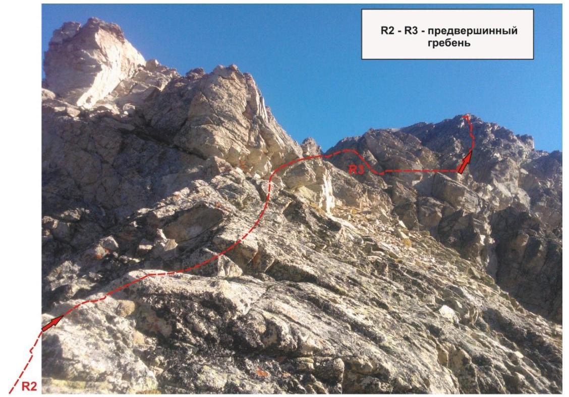
| R2–R3 Passage of the destroyed rocky ridge and approach under the summit tower. | 300 | 25 | Destroyed rocks, talus | 1 | Used: 0/0 left: 0/0 |
| R3–R4 Ascent to the summit | 150 | 45 | Inclined wall. | 2-, 2+ | Used: 0/0 left: 8/0 |
| R4 — summit Sarykolbashi-tersak (3776 m) | Large talus площадка, allowing safely разместиться two or more training and sports departments | ||||
| DESCENT | по пути подъёма |
Total:
Length of the route — 2520 m. Average steepness — 40°, on key sections — 55°. Character of relief — rocky
Sections:
- 1B cat. — 2 sections — 2300 m
- 2B cat. — 4 sections — 230 m
Used: hooks and закладных: 0/16. Left: hooks and закладных: 0/0
Section R1–R2. KEY ROUTE! Exit to the shoulder of the southern ridge through an inclined rocky wall
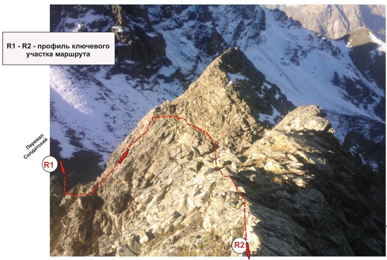
Start of section R2–R3 — saddle shoulder of the southern ridge. In the background — peak Itigibaши.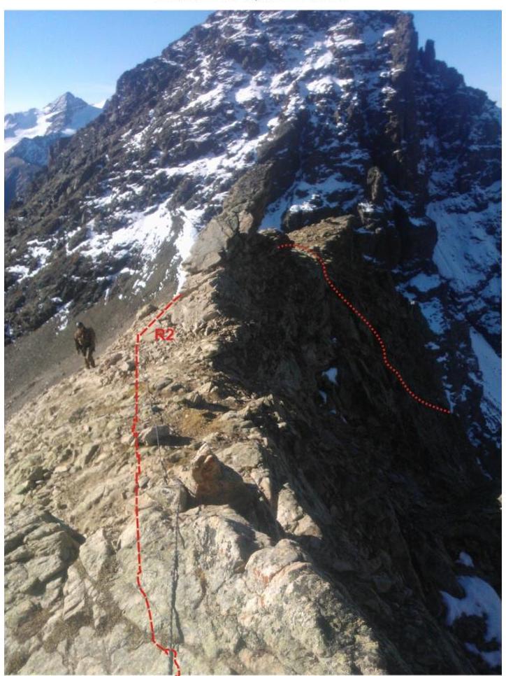
Comments
Sign in to leave a comment