2.4.147 Ascent Report
I. Description of the Traverse of Sakashil-Bashi Massif West — East
The first ascent of the route was made on February 22, 1969, by a group consisting of:
- Skobenko S.A. (leader)
- Vasyukovich L.A.
- Karlov A.I.
With the presence of an auxiliary group (observers) of 3 people.
Day 1. On February 21, the 2/1 group approached through the Khunaly-Chat gorge (the left, uppermost tributary of Sakashil-Su). The approach path to the old terminal moraine of the Khunaly glacier (Western Sakashil) is the same as for the peaks "Pik XXV-letiya kombinata", A. Baysultanov, and B. Orlov. After reaching the old terminal moraine, one must ascend left-upwards and, having reached the 1st moraine terrace, traverse left into the "pocket" between the right-bank moraine and the rocky slope of the spur separating the Khunaly-Chat and Sakashil gorges. Ascending up the "pocket", we reach the moraine ridge approximately 50 m above the glacier tongue. Two options are then possible:
- Reach the glacier and continue moving along it.
- Traverse to the rocky talus slope on the left (in the direction of travel), traverse it left-upwards, and reach the saddle of the "3500" pass.
Due to the glacier being heavily snow-covered (with loose snow), the group transitioned to the talus slope (photo 1). In summer, when the glacier is covered with firm névé, it's better to proceed along the glacier. The glacier is free of crevasses and gentle (with a slope of 15–20°, and up to 30° just below the pass). As there is no flat area for tents at the pass, the group ascended higher and set up camp in a snow drift under the ridge rocks, 30–50 m above the pass (photo 2).
Day 2. On February 22, 1969, at 6:00, the group departed from the bivouac and began ascending the snowy slope of the upper glacier plateau towards the "Uzlovaya" peak (photo 3). By circumventing the bergschrund on the right (counterclockwise, nearly at the unnamed peak to the west of "Uzlovaya"), the group reached the snowy ridge and ascended to the "Uzlovaya" peak by 8:00.
- The snow was not deep, not more than 20–25 cm, with ice beneath.
- Movement was simultaneous, with rope protection only from the bergschrund to the ridge.
The saddle between "Uzlovaya" and "1st Western" is not deep; it takes about 0.5 hours to reach the 1st Western peak, initially on snow and only near the summit on small rock outcrops.
Descent from "1st Western":
- Via a snowy corridor between rocks.
- Then down a snowy slope into a deeper saddle below "2nd Western" peak.
- A small gendarme is bypassed on the left.
Ascent to 2nd Western:
- Via a snow-covered (in winter) talus slope.
- Along heavily broken rocks on the left side of the slope, near the edge of the Western ridge (dropping left towards the NW buttress of the peak).
- The steep section is 4 rope lengths (photo 4). It takes about 1.5 hours from the 1st Western peak. No cairns or notes were found on any of these peaks, proving that the route was traversed for the first time.
The route to 2nd Western from the "3500" pass (via "Uzlovaya" and 1st Western), with descent via the ascent route, can be rated as category 2A.
Descent from 2nd Western — about 3 rope lengths down moderately difficult broken rocks to the saddle before the 3rd Western gendarme. The gendarme's height is not less than the 2nd Western peak, approximately 4050 m. The gendarme drops steeply on both the North side (to a steep snowy-icy slope) and the South side (into the Kestanty gorge), so it is tackled head-on:
- Initially on broken rocks and steep talus,
- Then 2 rope lengths on moderately difficult rocks to the "pre-summit" of the gendarme,
- Descent to the saddle (20–25 m of snow),
- From it, via icy rocks, exit to a ledge that allows bypassing the gendarme's summit on the left (photo 5).
One can ascend the gendarme's summit via a sheer inner corner for about half a rope length, but as the group was in a hurry to complete the route in daylight, they decided not to ascend.
Descent to the East is along quite difficult rocks but with many holds, taking about 2 hours, with protection via rock выступs. A small rocky pinnacle ("finger") immediately after the gendarme is bypassed on the left via a steep snowy slope (protection via ice axe). Further along the sharp snowy ridge, we approach the second (small) gendarme, which is also bypassed on the left via a steep snowy slope. Then, we ascend a snowy rise to the first (Eastern) gendarme, which is also bypassed on the left on snow.
After the gendarme, we descend into a deep saddle. On its right side is a small depression open to the South, with rock outcrops on both sides where one can rest. From the depression, we again ascend to the ridge (from here, the Main peak is visible), descend a snowy drift (2–3 m high) into a second, not deep but wide, snowy depression, and ascend a gentle snowy slope (150–200 m) to the Main peak. Movement from the Eastern gendarme onwards is always simultaneous.
We reached the Main peak at 13:30 (3–3.5 hours from 2nd Western). The Main peak (4100 m) is a small rock outcrop on the South side of the ridge. From the North, beyond the slope's inflection, it is not visible. Adjacent to the peak is a broken rocky ridge leading South to steep and long talus slopes in the Kestanty gorge. Apparently, a group of surveyors ascended via this ridge, installing a triangulation marker (a wooden pole with a cylinder) on the peak. No note was found in the cairn.
Descent from the peak is along the main ridge (snowy) to the East. Descent down the steep NE slope to the connecting ridge with the "Shirma" ridge seemed very steep and dangerous (ice). With little daylight remaining, the group decided to descend along the Eastern ridge to the Eastern glacier. Steep rocky sections of the ridge are bypassed on the South slope (right in the direction of travel), towards the Kestanty gorge. Finding a suitable descent point before the last steep rocky step of the ridge, short of the Unnamed pass, they descended to the Eastern glacier via a snowy-icy slope with a slope of up to 45° (Be cautious — crevasses below!).
Bypassing the "Shirma" ridge from the North, they signaled for the observers on the "3500" pass to descend. Meeting them at the lower (small) lake, they proceeded down the Sakashil gorge to the "round kosh" (2200 m), arriving in darkness.
The next day (February 23), they returned to Tyrnyauz town.
The entire traverse, from the "3500" bivouac to the lake (3100), took 11 hours. The group rates the route as category 2B.
Group Composition
| № п/п | Surname, I.O. | Year of birth | Sport. rank and instr. title | Ascent last season by cat. diff. 2, 3, 4, 5A, and 5B |
|---|---|---|---|---|
| 1. | Skobenko S.A. leader | 1949 | II | 2/3; 2/4; – |
| 2. | Karlov A.I. | 1949 | II | 2/3; 2/4; – |
| 3. | Vasyukovich L.A. | 1940 | III | 3/–; 2/–; – |
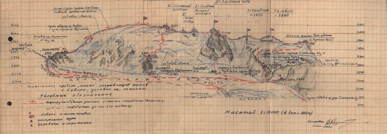 Panorama (unfolded) of the Sakashil-Bashi massif from the North with the routes marked.
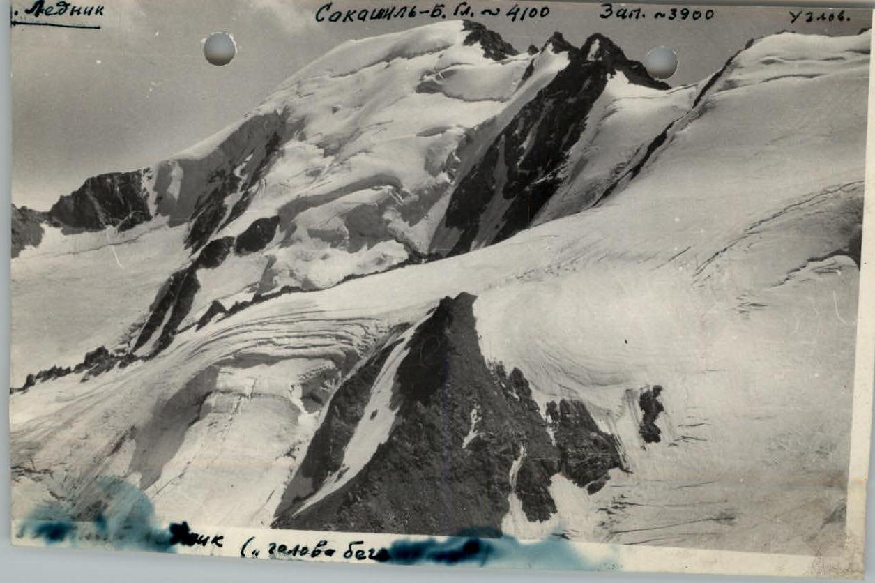
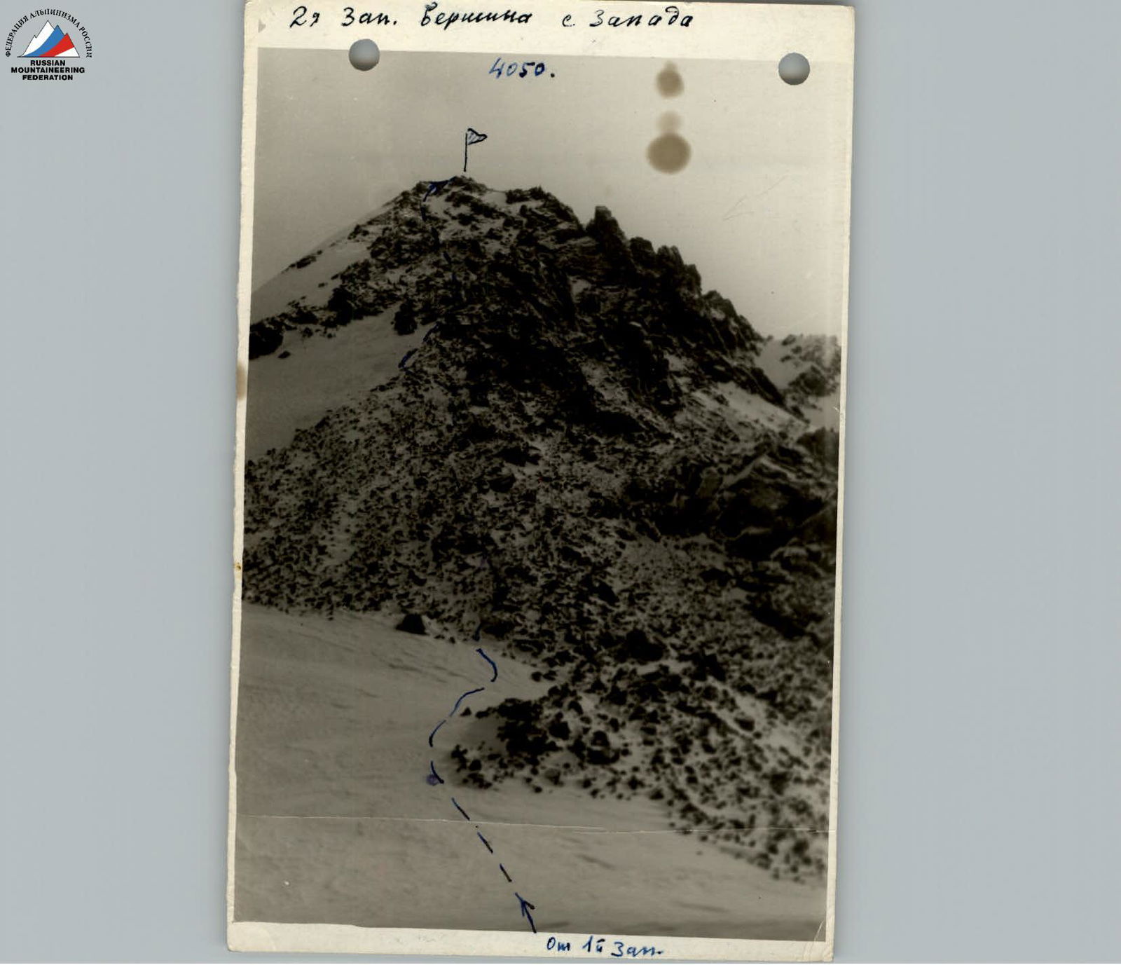 Photo #7 Upper reaches of the Sakashil and Khunaly-Chat gorges (Eastern branch), North wall of the Sakashil massif and Western Sakashil glacier from the NE ridge of "Pik im. XXV-letiya Tyrnyauz. Kombinata". August 1965, photo by G. Skorobogach.
 2nd West Peak from the West 4050. From 1st West.
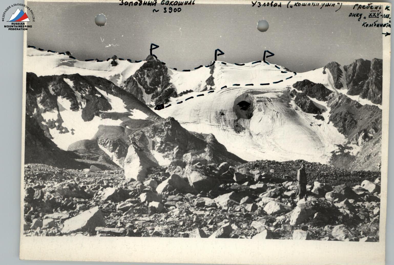 Photo #8. 2nd terrace (plateau) of the Eastern branch of the Khunaly-Chat gorge. The tongue of the Western Sakashil glacier — "hippopotamus head". In the background — the Sakashil-Bashi massif and the ridge leading to "Pik XXV-letiya Kombinata". August 1965. Photo by G. Skorobogach.
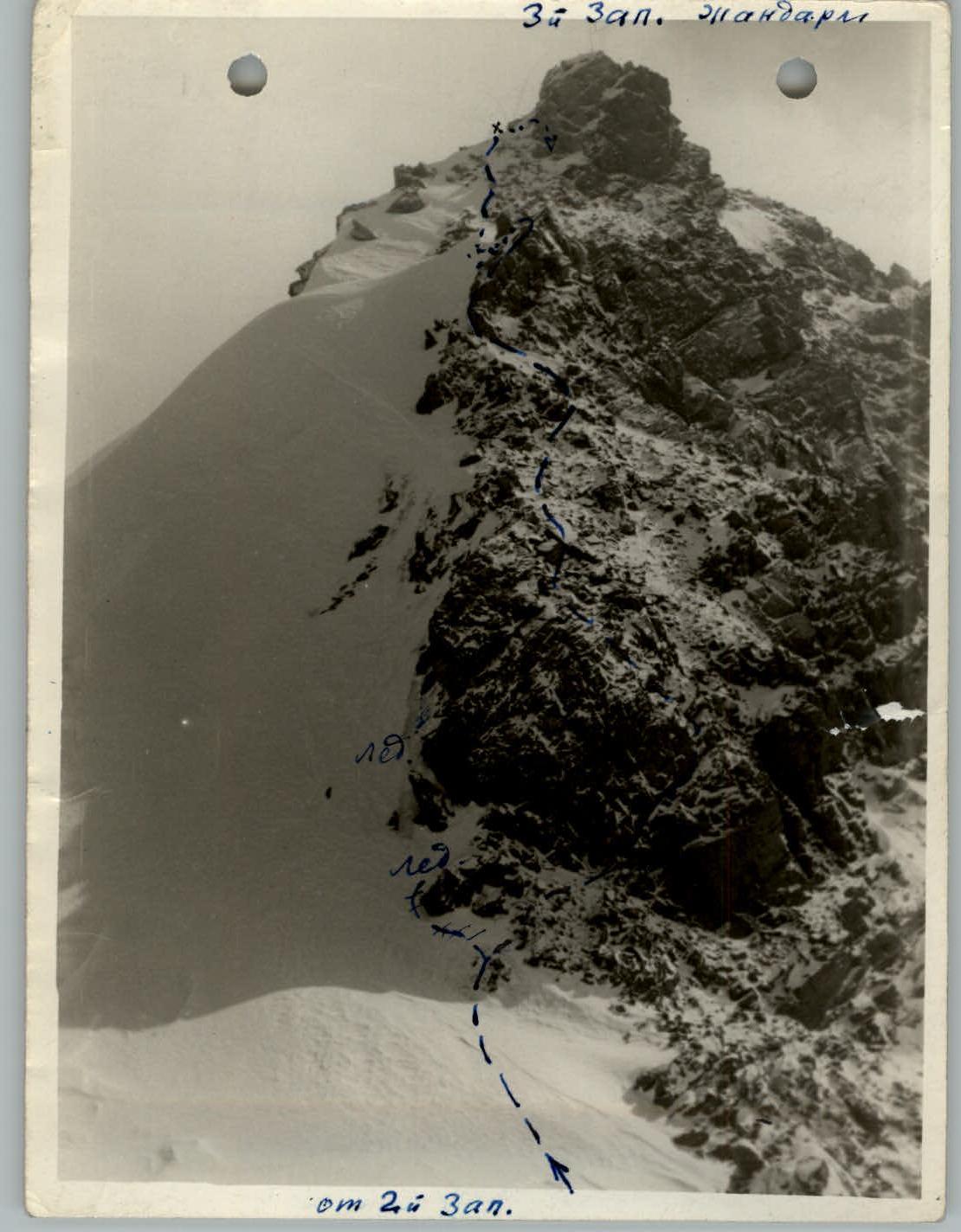 3rd West Gendarme from 2nd West.

 Western Sakashil ~3900. Uzlovaya ("cat's ears") ridge to Pik XXV-letiya Kombinata.
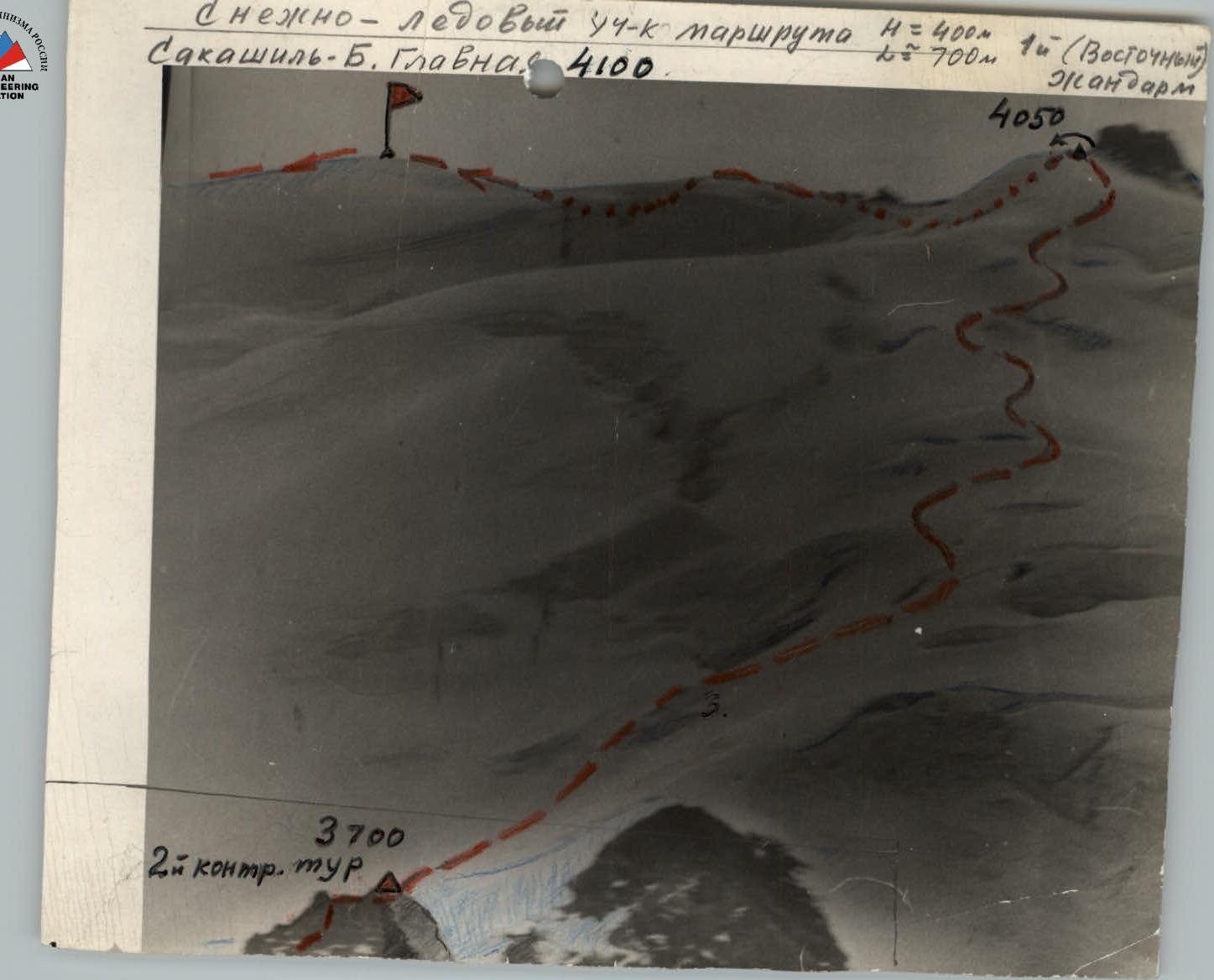
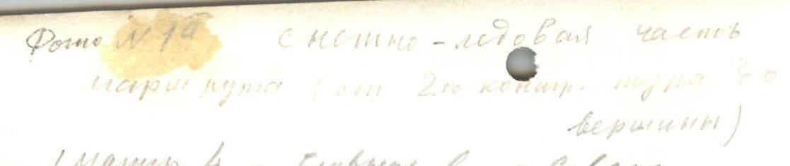 Snowy-icy section of the route L=400 m 1st (Eastern) Gendarme. Sakashil-B. Main 4100. 4050. 2nd control cairn.
 Photo #1. Snowy-icy part of the route (from 2nd control cairn to the summit). 1st route 4 — Main peak from the North. Group of Kuzmichev D.V. 14/9 69.