
Report on the first ascent by the team of the multipurpose mountaineering club "FRILINE" from Essentuki to the summit of Lkha (Western) 2625 m
via the SW couloir of the slope. Presumably Category 1B difficulty.
Team leader: Donskov Andrey Mikhailovich Coach: Motienko Nikolai Ilyich Essentuki
2017
Addresses:
357500, Stavropol Krai, Pyatigorsk, Sovetskaya St., 137, Motienko N. I. phone: +7-928-361-90-66, nik-motienko@mail.ru
357500, Stavropol Krai, Pyatigorsk, Mira St., 19, apt. 22, Donskov A. M. phone: +7-962-017-82-09, donskov91@mail.ru Coach: Motienko N. I.
357551, Stavropol Krai, Pyatigorsk, Engelsa St., 192, Semenova O. A. phone: +7-928-252-58-92, rijik001@yandex.ru. Coach: Motienko N. I.
357736, Stavropol Krai, Kislovodsk, Borgustanskaya St., 40, Rubanov V. A. phone: +7-928-300-01-09, darktrone666@yandex.ru. Coach: Motienko N. I.
682489, Khabarovsk Krai, Morskoy settlement, Morskaya St., 7, Rtishcheva I. A. +7-909-840-67-71, rtishcheva.i@yandex.ru.
Coach: Gorokhov K. G.
Ascent Passport
- Central Caucasus, Kestanty River gorge, section 2.4. From Chiperazau Pass to Gumachi peak
- Summit 2625 m (Lkha Western), via SW slope couloir
- Proposed category: 1B, first ascent
- Route type: rock
- Elevation gain: 460 m (GPS)
Route length: 1100 m.
Section lengths:
- Category I: 665 m
- Category II: 400 m
- Category III: 20 m
- Category IV: 15 m
- Category V: 0 m
- Category VI: 0 m.
Average slope: key section — 90°, entire route — 30°.
-
Belay points used: Total/ITO — 7/0 Rock pitons — 4 Anchor placements — 0 Belay points left on the route: none
-
Team's total climbing hours: 6 hours, 1 day
-
Team leader: Donskov Andrey Mikhailovich, 1st sports category Team members:
- Semenova Olesya Artemovna, 1st sports category, instructor 3rd cat. cert. No. 1838
- Rubanov Vladimir Anatolyevich, 3rd sports category
- Rtishcheva Irina Alekseevna, no category
-
Coach: Motienko Nikolai Ilyich, Candidate Master of Sports, instructor 1st cat. cert. No. 754
-
Route started: 13:10, April 22, 2017 Summit reached: 15:30, April 22, 2017 Return to camp: 19:10, April 22, 2017 Descent from summit: southeast via Lkha Pass
-
Multipurpose mountaineering club "FRILINE" Essentuki
-
Report responsible: Donskov A. M. phone: +7-962-017-82-09, donskov91@mail.ru
Description of the Ascent Area
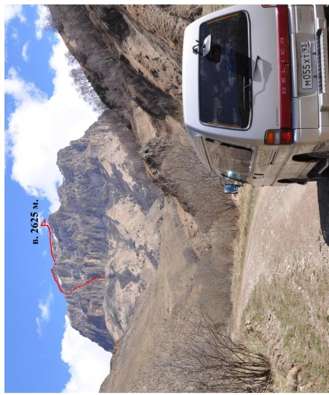
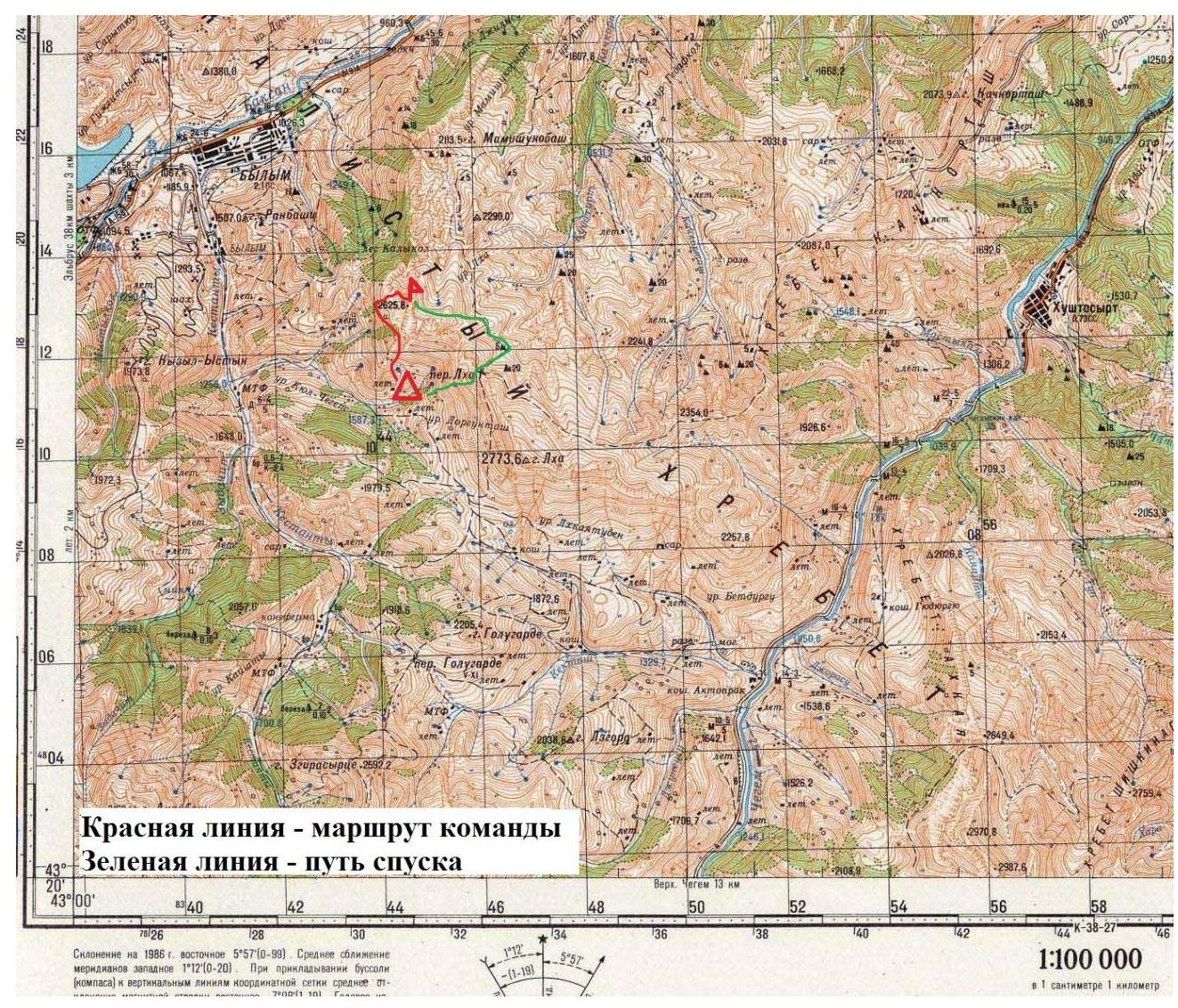
 The ascent object is located in the Kabardino-Balkarian Republic, Elbrus region, five kilometers east of the village of Byllym. The unnamed 2625 m peak is part of the Rocky Ridge system of the Greater Caucasus. The rocky bastion containing the 2625 m peak is cuesta-shaped, with steep rocky walls up to 400 m high facing south and southwest, and gentle grassy slopes to the north. The dominant peak in this bastion is Lkha, with an elevation of 2773 m, marked on the topographic map of the General Staff (Byllym K-38-015 1:100000, 1988 edition).
This section of the Rocky Ridge:
- is bounded to the east by the Chegem River,
- and to the west by the Baksan River.
Rivers flowing along the bastion's slopes:
- Kestanty River — along the SW slopes,
- Kektash River — along the SE slope.
The northern slopes of Lkha give rise to the Kachkortash River.
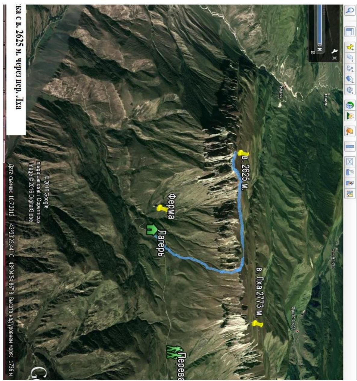
A base camp can be conveniently set up near the dirt road leading to Aktoprak Pass, directly opposite the southern wall of the 2625 m peak (8 km from Byllym village).
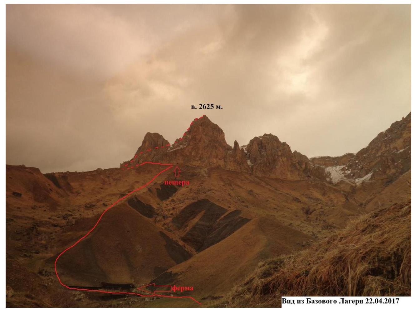
The ascent route proceeds:
- past a farm,
- left of a prominent gray scree slope,
- towards a visible cave in the southern wall (1.5 hours).
From the cave:
- left along the SW wall,
- crossing two gullies,
- emerging under the start of the couloir, which ascends to the right.
At the start of the couloir is a wedged "stone plug," marking the beginning of the route (15 minutes from the cave).
The descent from the 2625 m summit is most conveniently done via Lkha Pass (2466 m). A trail, previously used by locals for pack animals, passes through the pass.
No control tour or note was found on the summit. Mobile phone coverage in the area is unstable (Beeline, Megafon).
The road through Aktoprak Pass, connecting the Baksan and Chegem gorges, has good dirt road coverage but is often impassable in winter.
Map of the Ascent Area
Route Description
| Section | Length | Slope | Terrain | Difficulty | Belay Points |
|---|---|---|---|---|---|
| R0–R1 | 20 | 60–90 | rock | III–IV | 5 |
| R1–R2 | 200 | 30–50 | rock, scree | I–II | 0 |
| R2–R3 | 20 | 30–90 | rock, scree | I–IV | 1 |
| R3–R4 | 460 | 20–40 | rock, scree | I–II | 1 |
| R4–R5 | 400 | 10–20 | rocky ridge | I–II | 0 |
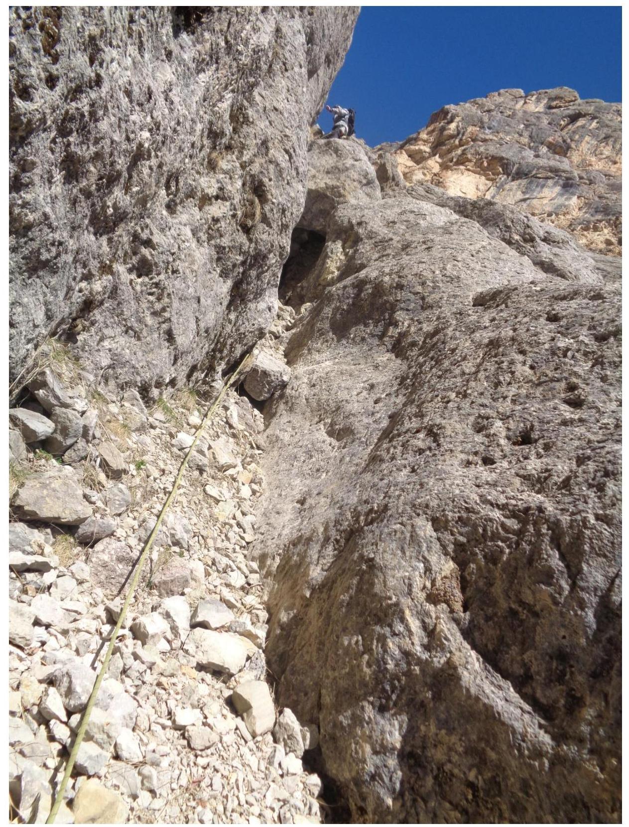
R0–R1: Couloir starting with a chimney, with a wedged "stone plug" at its upper part. Ascend the chimney to the plug, then move left. This is the key section of the entire route.
R1–R2: Move along the scree in the couloir, navigating несложные rock outcrops. Belay as necessary using terrain features. The couloir narrows with a "stone plug" ahead.
R2–R3: Ascend through the plug and continue up the couloir to a gentle, non-steep wall. Belay using terrain features.
R3–R4: Traverse the wall, enter the widening couloir, and follow its left side to the western ridge of the summit.
R4–R5: Follow the ridge, bypassing rock outcrops on the left, to reach the summit.
Photographs of Key Route Sections
Section R0–R1. Approaching the "plug"
Section R2–R3. Passing through the "plug"

Section R4–R5. Ridge traverse
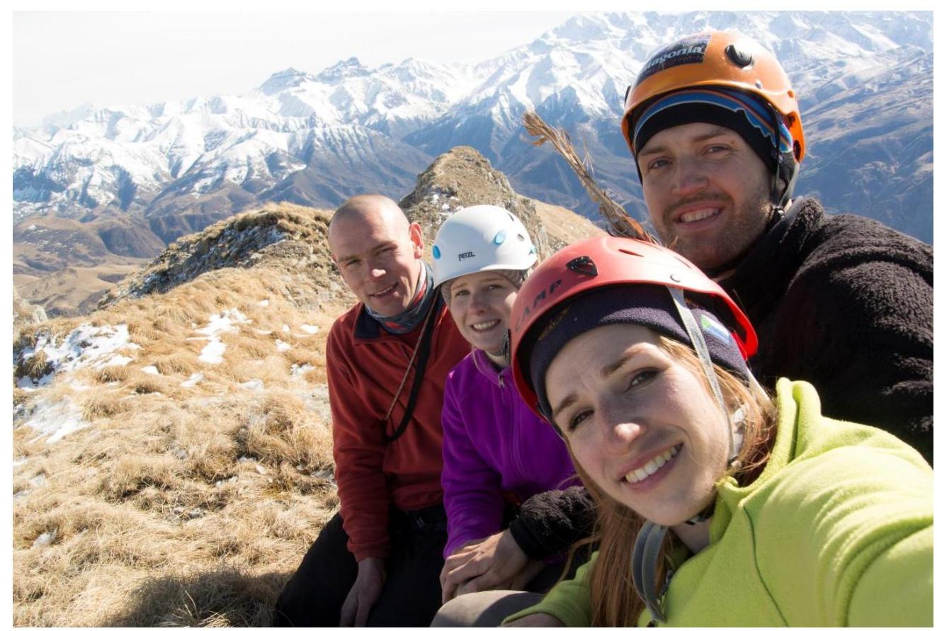
Group photo at the 2625 m summit.

Descent route from the 2625 m summit.
Descent from the 2625 m summit via Lkha Pass
Conclusions and Recommendations for the Route
The route corresponds to the assigned semi-category difficulty. The presence of sections with slopes up to 90° requires team members to have a solid understanding of mountaineering basics. The technical difficulty corresponds to a Category II route, but considering the relatively short length, the summit elevation below 3000 m, and the good accessibility of the summit, the team requests that this route be classified as Category 1B.
The official name of the 2625 m summit could not be established. If the Classification Committee decides to include this route in the classifier, the team proposes that it be listed as "2625 (Lkha Western)" as per the informational letter from A. N. Odintsov.
Comments
Sign in to leave a comment