Ascent Log
- Ascent category: rock climb
- Ascent area: Kabardino-Balkaria, Baksan River basin, upper reaches of
- Kamyk-Su River
- Peak, route: Gnitche-Tyrnyauz, 3555.6 m, via the Southwest Ridge
- Estimated category of difficulty: 2A, first ascent
- Elevation gain: 650 m
- total route length — 1000 m
- average steepness of the route — 50°
- Number of placements: 4
- Duration of climbing hours: 8
- Overnight stays: not required on the route
- Leader: Zaporochenko E. V., Candidate for Master of Sports, instructor 2nd category Participants: Krasnykh N. Yu., 2nd sports category
- Coach: Abduramanov R. U., Master of Sports of the USSR
- Departure on the route — September 13, 2001, and return
Diagram of the upper reaches of the Kamyk-Su River (left tributary of the Baksan River)
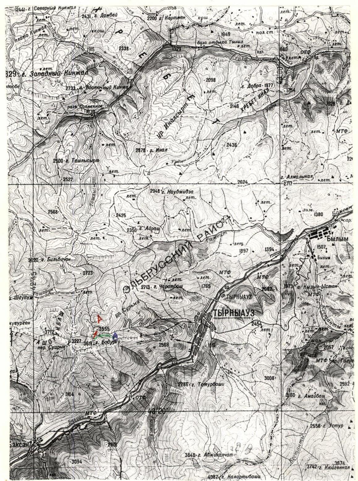
Legend
- Overnight stay location
- Approach path
- Route direction
- Gnitche-Tyrnyauz peak
Gnitche-Tyrnyauz peak (3555.6 m absolute elevation) is situated in a spur of the Ullu-Tyrnyauz ridge opposite the Bodurku peak (3619.5 m absolute elevation) above the Bodurku and Djaurgen passes (see diagram, fig. 1).
According to the "Classification of routes to mountain peaks" edition 1999, its location corresponds to section 2.4.1. "From the Gumachi peak to the Kitlod pass...".
The base (also the assault camp, overnight stay) can be set up on a flat area at the lower part of the ancient moraine complex under the mountain slope (~2700 m absolute elevation, photo 1).
The last spring exit is located ~70 m lower in elevation and ~350 m away in the slope of the old road excavation leading to the "Mukulansky" quarry (not operational), on the southeastern slope of the Gnitche-Tyrnyauz peak. However, there are no convenient platforms near the spring, and there is no water above. It is still possible to drive to the spring with a high-clearance vehicle, but the road has not been maintained for many years, and passage is problematic. The start of the road is at the checkpoint of the Tyrnyauz Mining and Processing Plant (special permits required). On foot — ~20 km with a height gain of 1400 m.
To the west of the overnight stay — moraines and the Bodurku pass, to the left — marble walls and towers of the Southern ridge (photo 2).
From the overnight stay, along the moraine ridges in the direction of the pass:
- Climb behind a steep marble wall (~200 m ascent)
- Traverse another 100 m along the scree
- Approach the base of the wide Southwest ridge
Start of the route. 2900 m absolute elevation (photo 3).
Route Description
Section R0–R1 (photo 3, 4)
Along a system of cracks, sticking to the left side of the ridge, but not crossing over to the areas of extremely unstable, very steep scree, using protection, sometimes through easily installed placements, along the marble massif upwards to a vertical wall of a tower type.
There are no specific characteristic points — the choice of movement is determined by the optimal (in terms of simplicity) option.
Overcoming this section includes:
- Several segments are traversed simultaneously
- Several segments require protection, with plenty of opportunities for organizing it
Length — about 450 m. Category of difficulty in free climbing averages 3+ (on average) ~60°.
Section R1–R2. Behind the tower on the ridge (marble) there is a small descent downwards (~10 m) and to the right — an inclined traverse upwards along a destroyed slope of crystalline schists to the base of the summit tower (more durable crystalline schists and
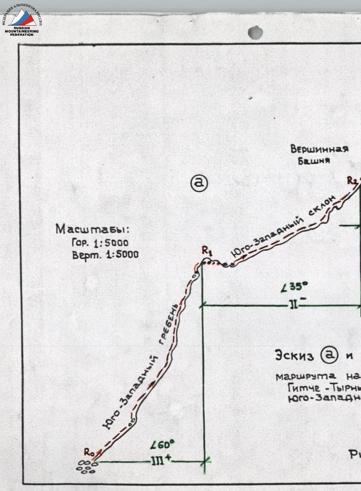
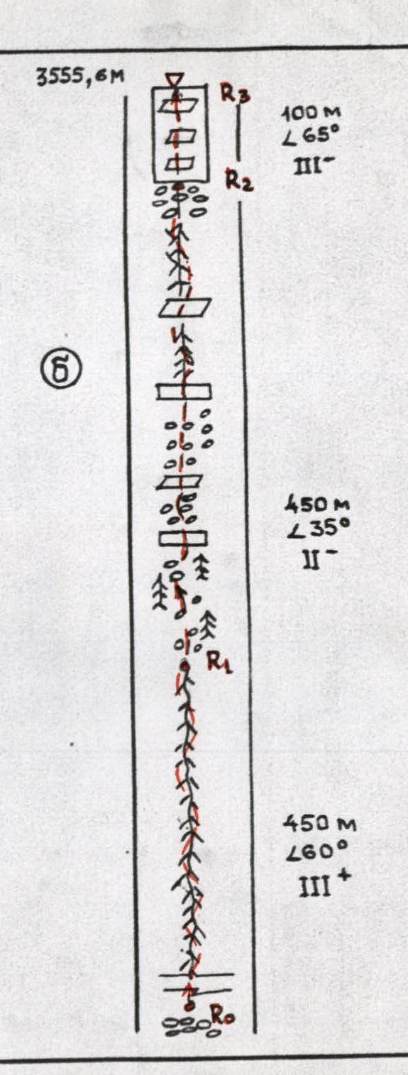
gneiss-granites). Movement is simultaneous, but there is also the possibility of organizing protection through placements. The length of this section is also about 450 m, but it is easier (2) and gentler (α ~35°) than the previous one. There are many horizontal and inclined ledges, scree, or heavily destroyed sections.
Section R2–R3. The summit tower. Although it is steep (~65–70°), it has many ledges and cracks, which facilitates the ascent and organization of protection. Difficulty — 3. The choice of movement is dictated by the morphology (relief) of the wall, allowing for "maneuvering". Total length — ~100 m. At the summit, a cairn is built, and a note is left.
Descent:
- To the north along the ridge, towards the Djaurgen pass — corresponds to category 1B.
- Halfway to the pass, there is a point on the ridge where you can descend along the scree slope to the southeast towards the Tyrnyauz River (the aforementioned spring and overnight stay).
- The path to the Bodurku pass along the Western ridge to the Gnitche-Tyrnyauz peak — is more complex (category 2B–3A).
- The Southern ridge — category 3A–3B.
The Gnitche-Tyrnyauz peak (like Bodurku) is marked on all state topographic maps (scale 1:25000, 1:50000, and smaller).
Author of the description and photographs: E. V. Zaporochenko
 Pyatigorsk
October 2001
Pyatigorsk
October 2001
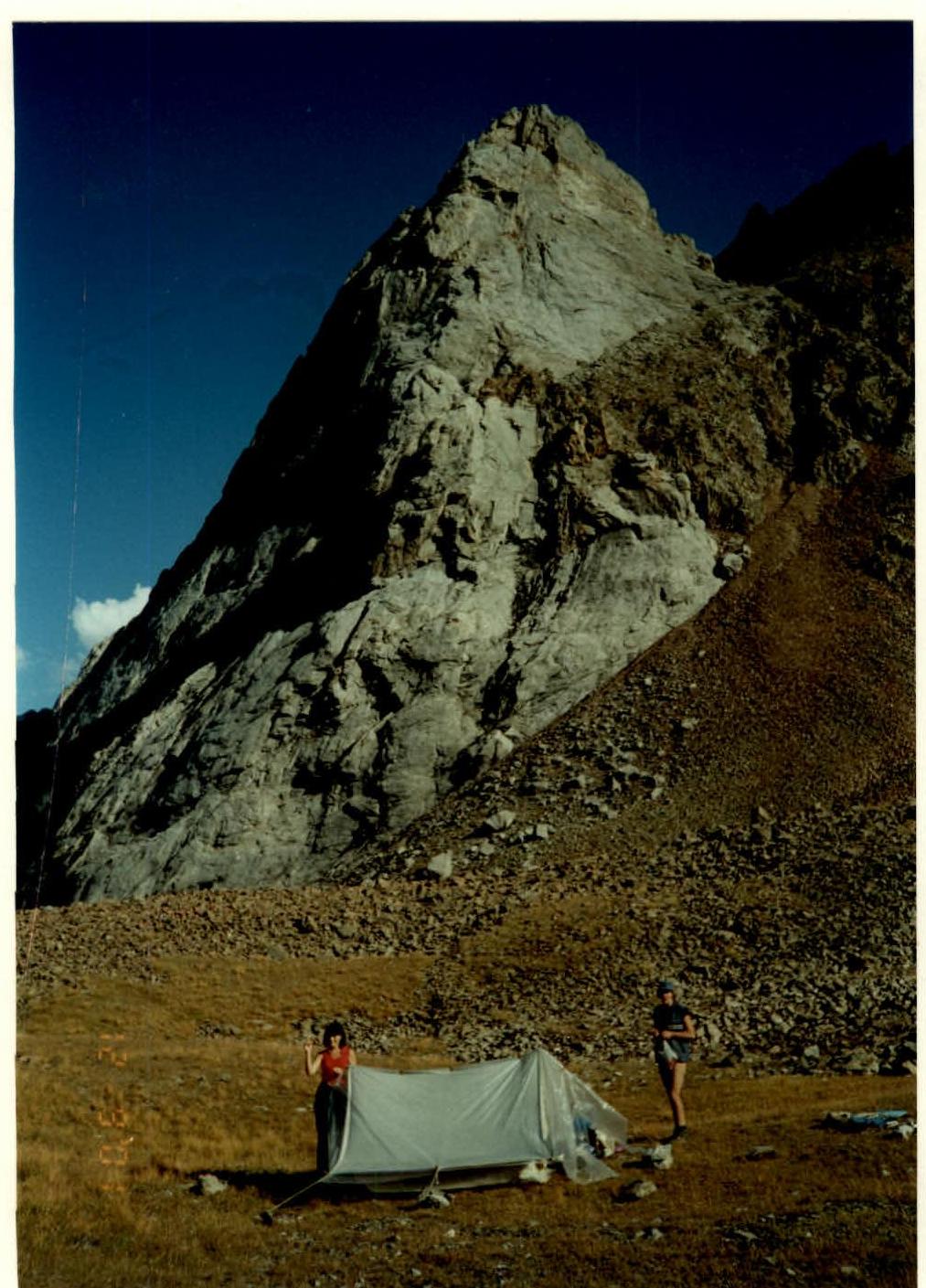
Photo 1. Base camp (overnight stay) in a thermokarst sinkhole (moraine cover over buried ice) at the foot of Vera Peak (composed of marbles).
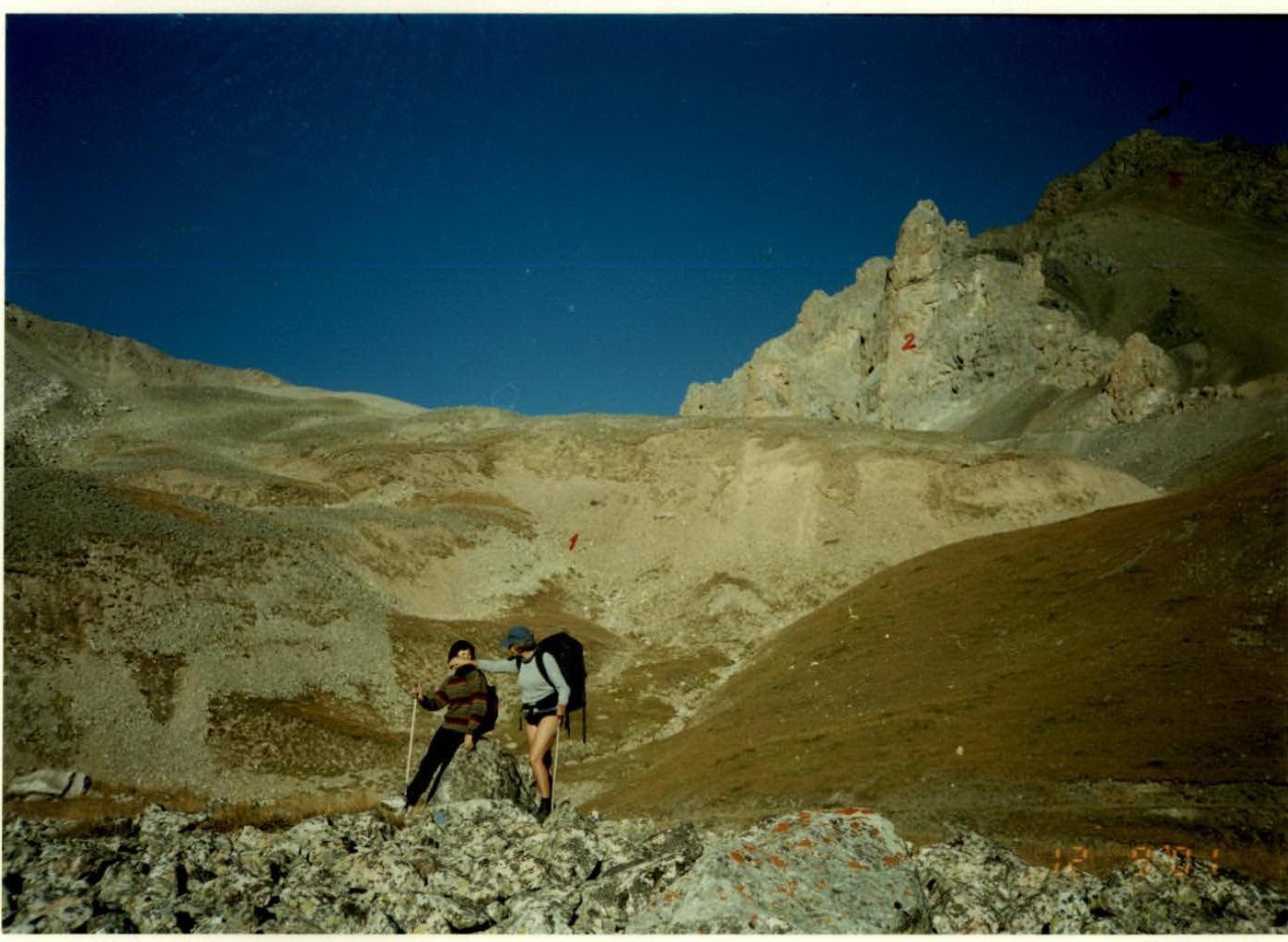
Photo 2. View of the moraine (1) in the upper reaches of the Tyrnyauz River valley (no water flow) and the southwest ridge of Gnitche-Tyrnyauz peak:
- (2) — marbles;
- (3) — crystalline schists.
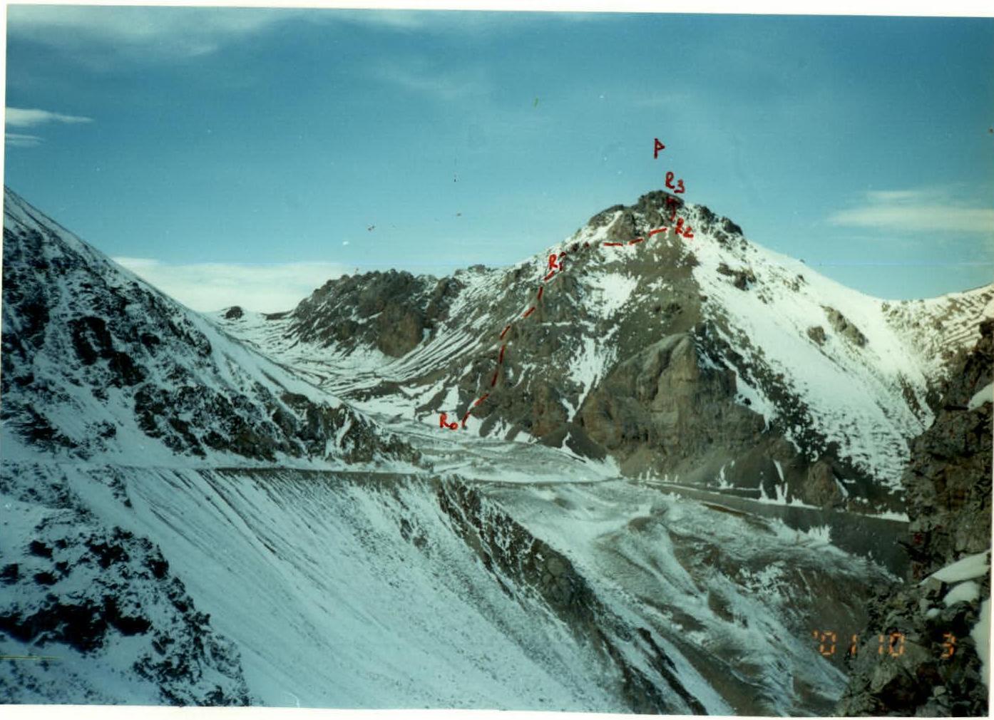
Photo 3. Gnitche-Tyrnyauz peak from the ridges of the Ullu-Tyrnyauz ridge (area of the " Vysotny" quarry, 3000 m absolute elevation):
- P — peak;
- R2–R3 — route sections.
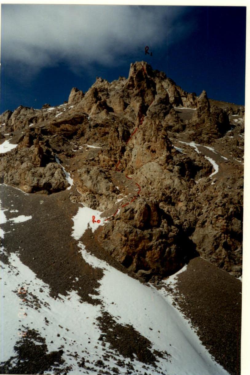
Photo 4. Initial section of the route. View from the opposite (northern) slope of the Ullu-Tyrnyauz ridge.