Description
Ascending "Piki Aviatsii" Peak via the South Face, Category 2B difficulty
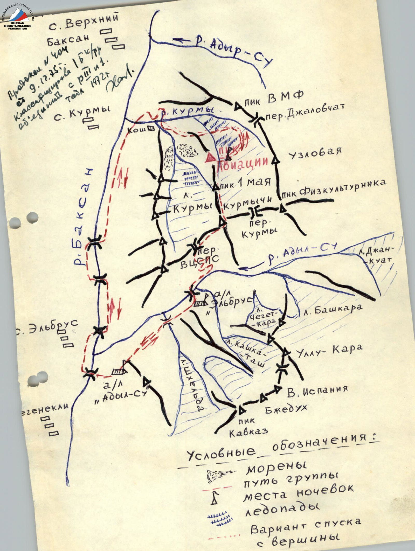
Location: Elbrus region, Kurmy valley, Kurmychi glacier (upper part).
Route characteristics: south face, rocky.
Route: ascent via the south face (from the Kurmychi glacier moraine).
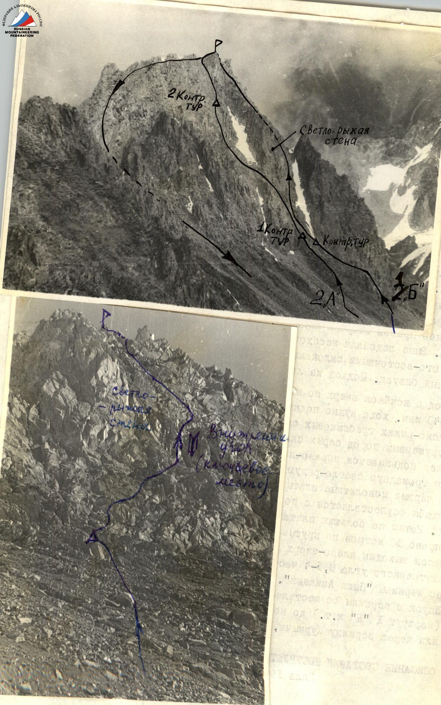
Characteristics of the peak:
- the peak is located in the lower part of a spur connecting the Kurmychi (4056 m), May 1st Peak, and Piki Aviatsii peaks;
- like all peaks in the MRP peaks area, Piki Aviatsii Peak is a heavily destroyed rocky massif with a wedge-shaped structure featuring a cascade of ledges, walls, and internal corners;
- the route's rocks are covered with fragments of destroyed rocks;
- it is essential to be constantly aware of the rockfall hazard on the route.
Route Description
From the "Adyl-Su" alpine camp, the path lies down the highway of the Baksan valley to the Kurmy settlement. From the settlement, head right and up along a good trail on the left bank of the Kurmychi river. The path passes by a waterfall and a meadow on the moraine. Then, cross to the right bank of the river and proceed along it to the tongue of the Kurmychi glacier. Staying on the right side of the glacier, ascend the icefall to the snowy plateau of the glacier. Above the icefall, turn right and reach the scree moraine under the southeastern slopes of Piki Aviatsii Peak. The initial bivouac is located here on the scree. The approach from the camp takes 1 day.
Depart from the overnight stay at 4:00, ascending the Kurmychi glacier moraine. After 35–40 minutes of walking, ascend up the fine scree, keeping to the right of the red-golden comb-like rocks (the latter stand out significantly among the destroyed gray rocks).
Continue ascending right-up along the ledges of destroyed rocks under a vertical massive light-red rock. The latter is bypassed on the right, aiming for the black monolithic slabs. Ascend via a slightly pronounced internal corner (15–20°) using piton belay — this is the key section. Then, ascend straight up 40–50 m along large slabs. After that, move right for 30 m along steep monolithic slabs (caution — loose rocks!). Then, exit left-up onto a snowy saddle. The ascent from the internal corner to the saddle takes 3.5–4 hours. From the saddle, 30–40 m of difficult climbing lead to the summit of "Piki Aviatsii" Peak.
The descent from the summit is done:
- via the south couloir;
- or the west ridge (Category 1B difficulty route).
To the initial bivouac overnight stay and further along the ascent path or via Kurmychi Peak, VTsSPS pass into the Adyl-Su valley.
Description compiled by instructor A.Ya. Oleinikov.
July 1975.
Protocol of Ascent Analysis (First Ascent)
To "Pik Aviatsii" Peak via the south face, approximately Category 2B difficulty.
Attendees:
A.Ya. Oleinikov — leader E.A. Sokolenko — deputy leader A.Kh. Morgoev E.I. Golosnoy A.Ya. Bobrovnik Yu.D. Shilov
Head of the training section: Yu.D. Shilov Head of the rescue team: D.P. Sukhodolsky
Departed from the overnight stay (upper part of the Kurmygi glacier) at 3:50. After ascending the scree for 40 minutes, the group approached the comb-like red-golden rocks. Then, ascended along the ledges under the light-red wall (rock) and further, straight up along monolithic rocks (piton belay), exited onto a saddle and the summit. The route is rocky and quite challenging. In the group's opinion, which made the first ascent, this route is worthy of Category 2B difficulty and is recommended for educational and sports ascents. There are almost no rockfall hazard sections on the route. The rocks are dry and monolithic.
Head of the training section, Yu.D. Shilov: I propose that the leader, A.Ya. Oleinikov, be credited, and the participants be credited with the ascent, and that the group be required to formalize the documentation of the first ascent of Category 2B difficulty.
August 2, 1974.