
ADDRESSES:
LLC SOAB "Ullutau": 361602, KBR, Nalchik, Ph. 8-8662-77-09-87
TEAM LEADER (report-related issues): 300001, Tula, Karla Marksa St. 130, A.V. Rasskazov home ph. 8-4872 42-59-94 E-mail: tulalp@yandex.ru
COACH: 360017, KBR, Nalchik, Kirova St. 12, apt. 50, Yu.I. Porokhnya home ph. 8-8662-74-08-65
Elevations marked in the report were determined visually and with the aid of the main rope.
The Main Caucasian Range and its spurs from Chipperazau Pass to Ortokara peak
REPORT
on the first ascent of Shogentsukova peak (4050 m) via the left edge of the South-Eastern wall from July 11 to July 13, 2009, by the sports group of LLC SOAB "Ullutau" consisting of:
- A.V. Rasskazov — team leader
- E.V. Ogurtsov — participant
- O.M. Makalov — participant
- V.F. Konovalov — participant
LLC SOAB "Ullutau" 2009
Appendix 1.
ASCENT DOCUMENTATION
- Mountain system: Caucasus Region: Central Valley: Adyrsu Peak name: Shogentsukova peak, 4050 m Peak number according to the 2001 classification table: 2.4.164
- Route name: via the left edge of the South-Eastern wall;
- Category of difficulty: 4B (approximate) Type of ascent: first ascent;
- Route nature: rock climbing
- Route characteristics:
Height difference: 460 m
Route length: 960 m
Section lengths:
- 5th cat. diff.: 28 m
- 4th cat. diff.: 110 m Average steepness:
- main part of the route: 72°
- entire route: 58°
- Number of protection points and ITO used on the route: total: 26 pieces including pitons: 0 chocks: 26 pieces Pitons left on the route: 0
- Team's travel time on the route: 10 hours, 1 day;
- Team leader: Rasskazov Alexander Valentinovich, Sports qualification: Master of Sports of the USSR Participants: Ogurtsov Evgeny Vitalievich, 1st sports category Makalov Oleg Mikhailovich, 2nd sports category Konovalov Vladimir Fedorovich, Candidate Master of Sports of the USSR;
- Coach: Porokhnya Yuri Ivanovich, Sports qualification: Honored Master of Sports of the USSR;
- Route start: July 12, 2009, 6:00 Summit reached: July 12, 2009, 16:00 Return to Base Camp: July 12, 2009, 19:00

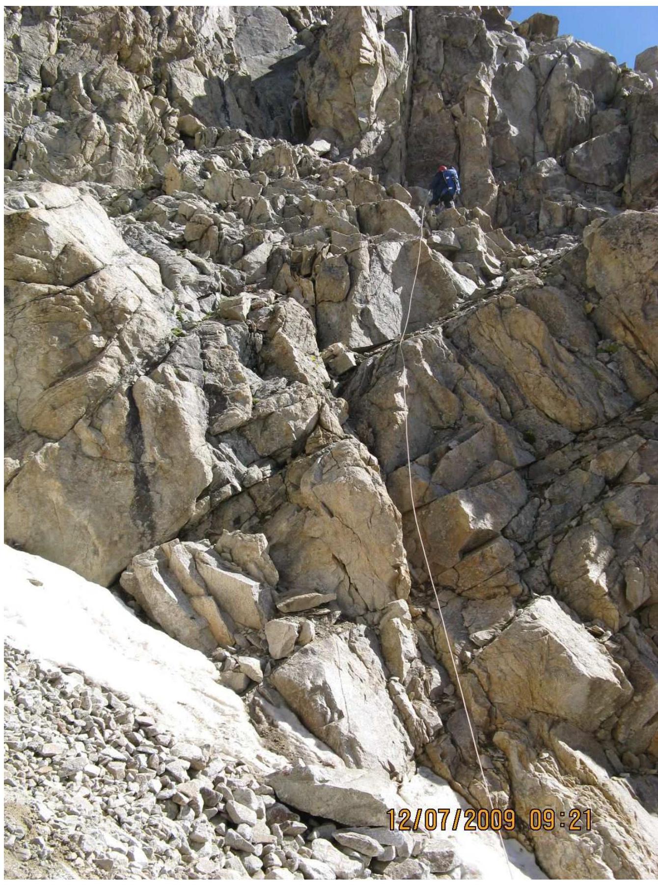
Photo 1. General view of the left edge of the SE wall
Brief overview of the ascent area and history of exploration
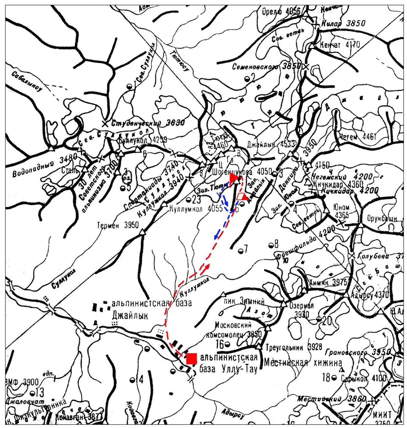
Shogentsukova peak (4050 m) is located in the northwestern spur of the Main Caucasian Range (Adyr spur of the MCR or Adyr Range).
It is situated between Tyutyu East peak (4369 m) and Dzhailyk peak (4533 m) on the southern spur-ridge extending from the eastern shoulder of the Tyutyu massif.
The Adyr spur is considered the coldest place in the Adyrsu region, as the elevations of the Adyr Range peaks are significantly higher than those of the MCR peaks in this area.
The peak was first ascended in 1934 when on August 11, the duo L. Gutman — B. Berkovich ascended via the Western slope to the peak, then known as Central peak and later renamed Shogentsukova peak.
In 1965, on July 10, a group led by E. Fomushkin ascended to the peak via the Southern ridge, establishing a route of 2B category.
In 2007, on July 18, a sports group from Ullutau alpine base led by A.P. Olik ascended to the peak via the South-Eastern wall, completing a route estimated at 4A category, which was repeated on August 6 of the same year by a group led by Morozova I.Yu.
According to the "Classification of Routes on Mountain Peaks" by the Russian Alpine Federation (2001 edition), on Shogentsukova peak, there is a 1B combined route of 1B category via the Western slope, as well as a route via the Southern ridge of 2B category.
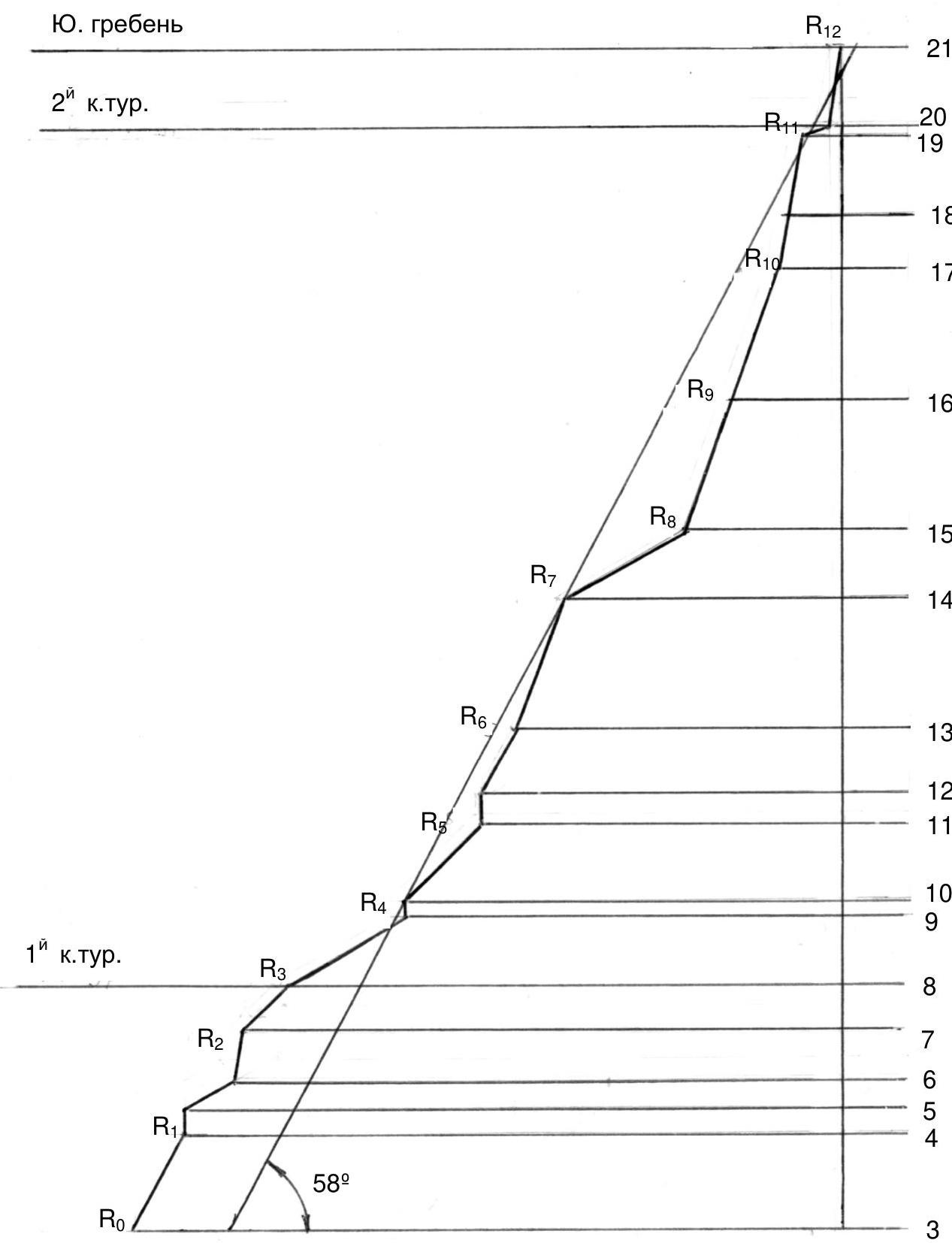
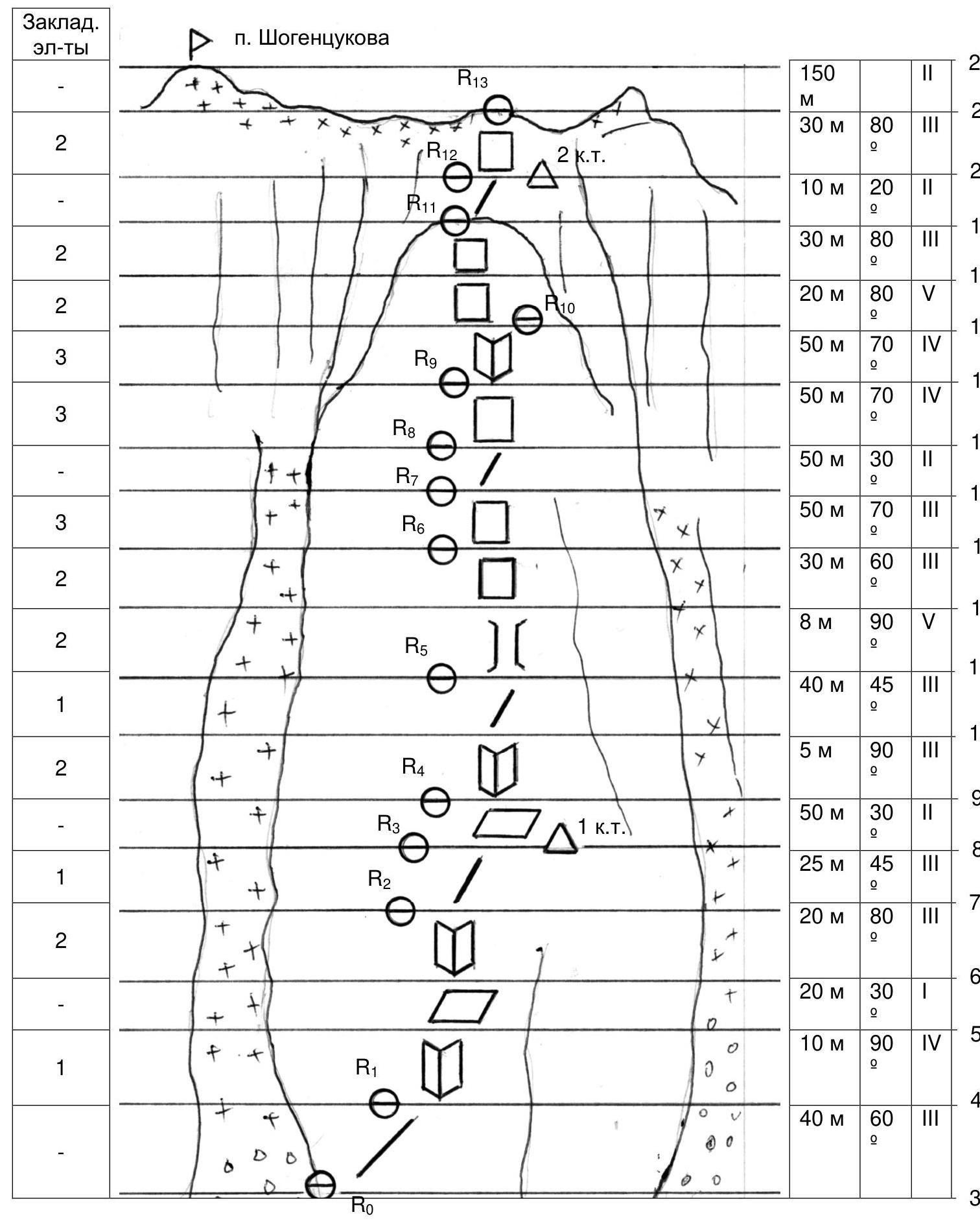
Route description by sections
R0–R1: From the overnight stay on the moraine under the Zapadny Dzhailyk glacier, first to the end of the moraine, then left onto the scree slopes along the glacier.
R1–R2: 150–200 m, Ascend a steep (up to 45°) scree slope to reach under the left edge of the SE wall of Shogentsukova peak, separated from it by two deep couloirs;
R2–R3: Ascend the left couloir for 50 m along its lower scree part, bypassing the lower part of the edge, to a vaguely defined internal corner;
R3–R4: Ascend rightwards and upwards through simple rocks (40 m, 60°, 3rd cat. diff.) to a clearly defined 10-meter internal corner;
R4–R7: Ascend the internal corner (10 m, 90°, 4th cat. diff.), then (R5–R6) along a gentle scree ledge (20 m, 30°) and through a destroyed internal corner 20 m, 80°, 3rd cat. diff. (R6–R7) to reach the ridge;
R7–R8: Move along the ridge (25 m, 45°, 3rd cat. diff.), at the end of which the 1st control cairn is established.
R8–R9: Continue along a terrace (50 m, 30°, 2nd cat. diff.) to bypass a rock gendarme on the right and another 40–50 m simultaneously under the ascent of the destroyed ridge;
R9–R11: Ascend a 5-meter sheer internal corner (R9–R10) and then (R10–R11) along the right part of the ridge (40 m, 45°, 3rd cat. diff.) to approach under the wall;
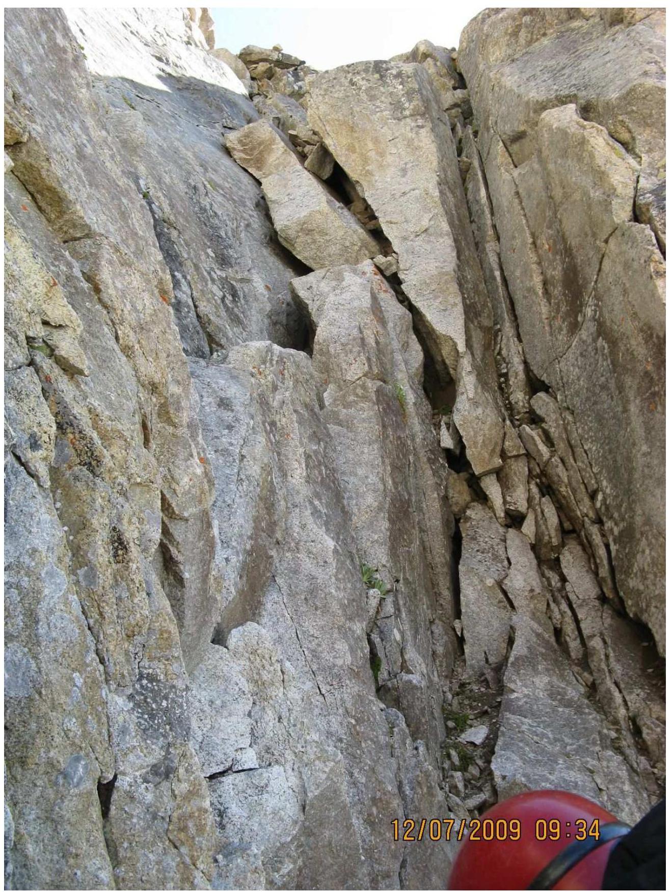
R11–R13: Ascend an 8-meter sheer chimney (R11–R12) of 5th cat. diff. with a flake on its left wall and then 30 m (60°, 3rd cat. diff.) along a wide ridge to a large ledge;
R13–R14: 50 m, 70°, 3rd cat. diff. — continuation of the wide ridge
R14–R15: A gentle ridge crest (50 m, 30°, 2nd cat. diff.) leading to the base of the tower;
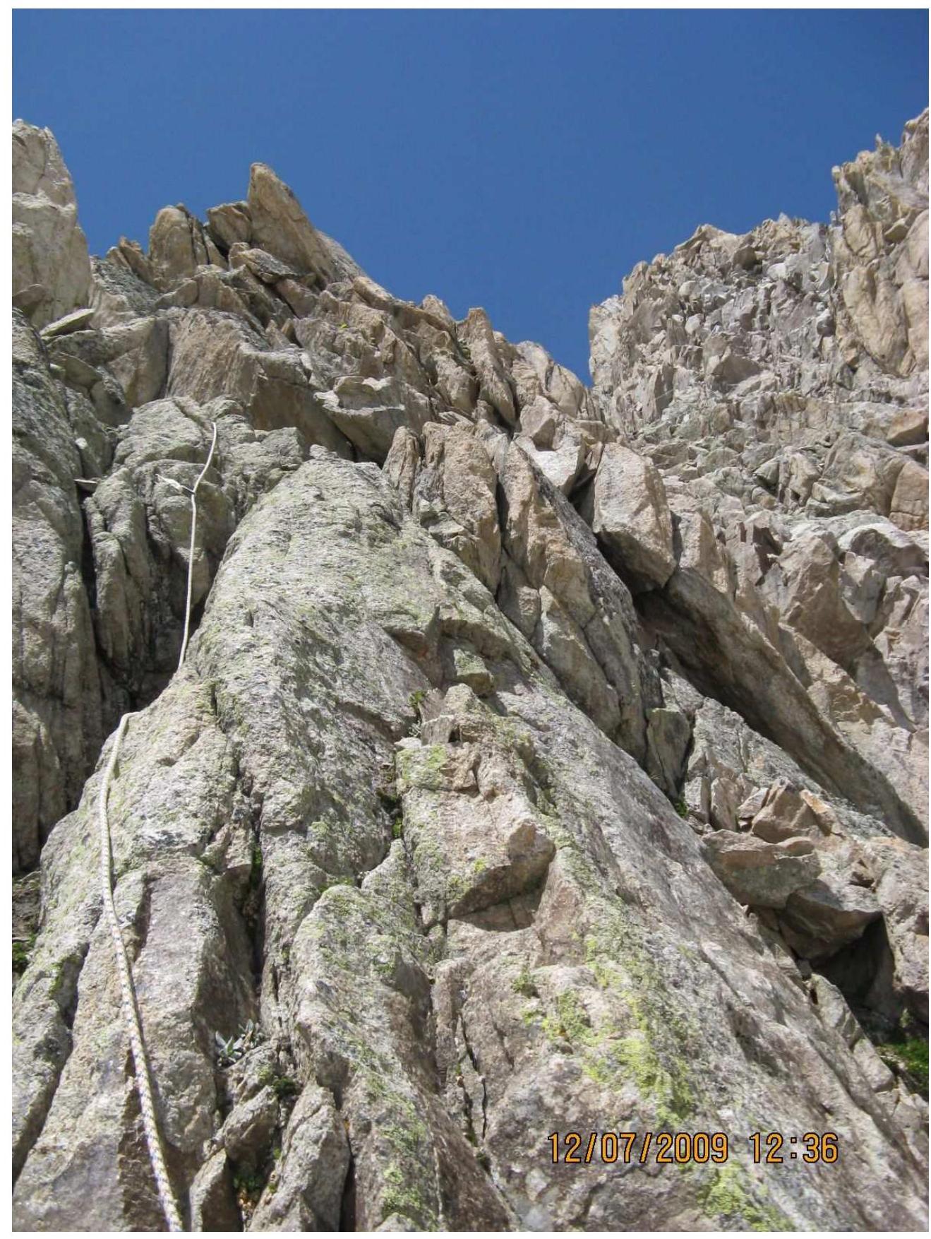
R15–R16: Initial section of the tower – 50 m, 70°, 4th cat. diff. along the right part of the tower;
R16–R17: A wide internal corner 50 m, 70°, 4th cat. diff. on the right side of the tower, exiting to the central part;
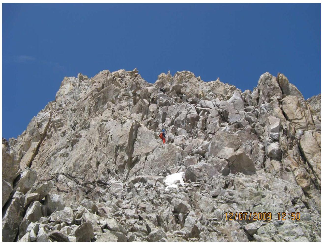
R17–R19: Ascend the central part of the tower 20 m, 80°, 5th cat. diff. (R17–R18), then 30 m 3rd cat. diff. (R18–R19), exiting to the top of the tower;
R19–R20: A 10-meter gentle (20°) summit part of the tower, at the end of which on a ledge behind a flake the 2nd control cairn is established.
R20–R21: A heavily destroyed wall (30 m, 80°, 3rd cat. diff.) leading to the snowy part of the Southern ridge of Shogentsukova peak;
R21–R22: A 150-meter section of the snowy ridge, exiting to Shogentsukova peak. Descent towards the Zapadny Tyutyu glacier and then to the base camp.
Profile diagram of the wall part of the route (without the ridge part) Scale 1:2000
Route diagram in symbols
Tactical actions of the team
July 11, 2009. At 7:00 the team left the Ullutau alpine base and by 11:00 arrived at the overnight stay at the end of the moraine between Shogentsukova peak and Dzhailyk peak, setting up a bivouac.
On the same day, a reconnaissance of the approach path under the route was conducted, with a visual inspection and photographing from the Zapadny Dzhailyk glacier of the route options, and the chosen route was selected.
July 12, 2009. At 6:00 the team left the bivouac and by 7:00, having ascended a steep scree slope about 150–200 m, approached under the SE wall. It took another two hours to finalize the possible ascent route, requiring an ascent to visually inspect the initial sections of the two couloirs cutting through the left part of the SE wall. As a result of both the previous day's reconnaissance and the inspection of the wall's lower part, it was decided to abandon the initially planned path "through the center of the left part of the SE wall" because:
- the "center of the left part" was cut by a deep couloir separating the left edge from the wall's main body;
- the lower part of the wall was heavily dissected and destroyed, and also stood away from the main wall massif.
Therefore, a more logical and straightforward route, named by us as "via the left edge of the SE wall," bounded by two deep couloirs cutting through the SE wall's massif almost to the ridge, was chosen as the object of ascent.
The team began work on the route around 9:00. Bypassing the start of the rock edge on the left through a scree couloir in the lower part (~50 m, 50°), they exited rightwards onto the rock ridge, starting movement in pairs: Rasskazov A.V. — Ogurtsov E.V. and Makalov O.M. — Konovalov V.F. Having ascended 40 m through simple rocks to a clearly defined 10-meter internal corner, they set up a belay station.
Further ascent was made through the internal corner, then along a gentle (~30°) scree ledge 20 m and through a destroyed internal corner (20 m, 80°, 3rd cat. diff.) to exit onto the ridge. Belay station.
From the station, movement was along the ridge (25 m, 45°, 3rd cat. diff.), at the end of which the 1st control cairn was established.
Further movement was along a terrace (~50 m, 30°) to bypass a rock gendarme on the right and another 40–50 m simultaneously traversing under the ascent of the destroyed ridge. Belay station.
Having ascended a 5-meter sheer internal corner and then ~40 m (45°, 3rd cat. diff.) along the right part of the ridge, they approached under the wall. Belay station.
Up to the mentioned belay station and intermediate protection points were organized mainly using sling runners attached to rock outcrops. During further movement, chocks of various types and sizes were also used.
From the station, movement was through an 8-meter sheer chimney of 5th cat. diff. with a flake on its left wall and further 30 meters (60°, 3rd cat. diff.) along a wide ridge to a belay station on a large ledge.
The next section (50 m, 70°, 3rd cat. diff.) led to a gentle (30°) 50-meter ridge crest exiting to the base of the tower.
The ascent of the tower included 3 sections of 50 m (the first two — ~70°, 4th cat. diff. along the right part of the tower, the third — leading to the top of the tower — ~80°, with a 20-meter initial wall of 5th cat. diff.). The last two sections were climbed with the organization of fixed ropes.
The summit 10-meter gentle part of the tower leads under a heavily destroyed wall, under which on a ledge the 2nd control cairn was established.
The wall (30 m, 80°, 3rd cat. diff.) led to the snowy part of the Southern ridge of Shogentsukova peak. Along a simple snowy ridge to the left ~150 m simultaneously to the summit.
The team reached the summit at 16:00. Descent towards the Zapadny Tyutyu glacier began at 16:20, and by 18:00 they descended to the overnight stay on the shoulder of Shogentsukova peak.
July 13, 2009. The team's return to the Ullutau alpine base was at 13:00.
Conclusions and recommendations:
- the route is purely rock climbing with a large number of "loose" rocks, especially in the lower part;
- it is advisable to approach the route's level from the Zapadny Dzhailyk glacier the day before the ascent to orient oneself according to the description and photographs to identify the entry couloir;
- there were no convenient places for a bivouac on the route. On gentle sections, platforms can be created if necessary;
- emergency evacuation from the route up to section R12–R13 is possible through one of the lateral couloirs, but attempts to shorten the route by ascending one of the lateral couloirs followed by an exit to the ridge appear to be ineffective due to their either being practically equivalent to the path along the ridge, which is safer, or being more challenging.
MAP — DIAGRAM OF THE ASCENT AREA
Conventional symbols:
| LLC SOAB "Ullutau" | |
| overnight stays | |
| Shogentsukova peak | |
| approach path | |
| return path |
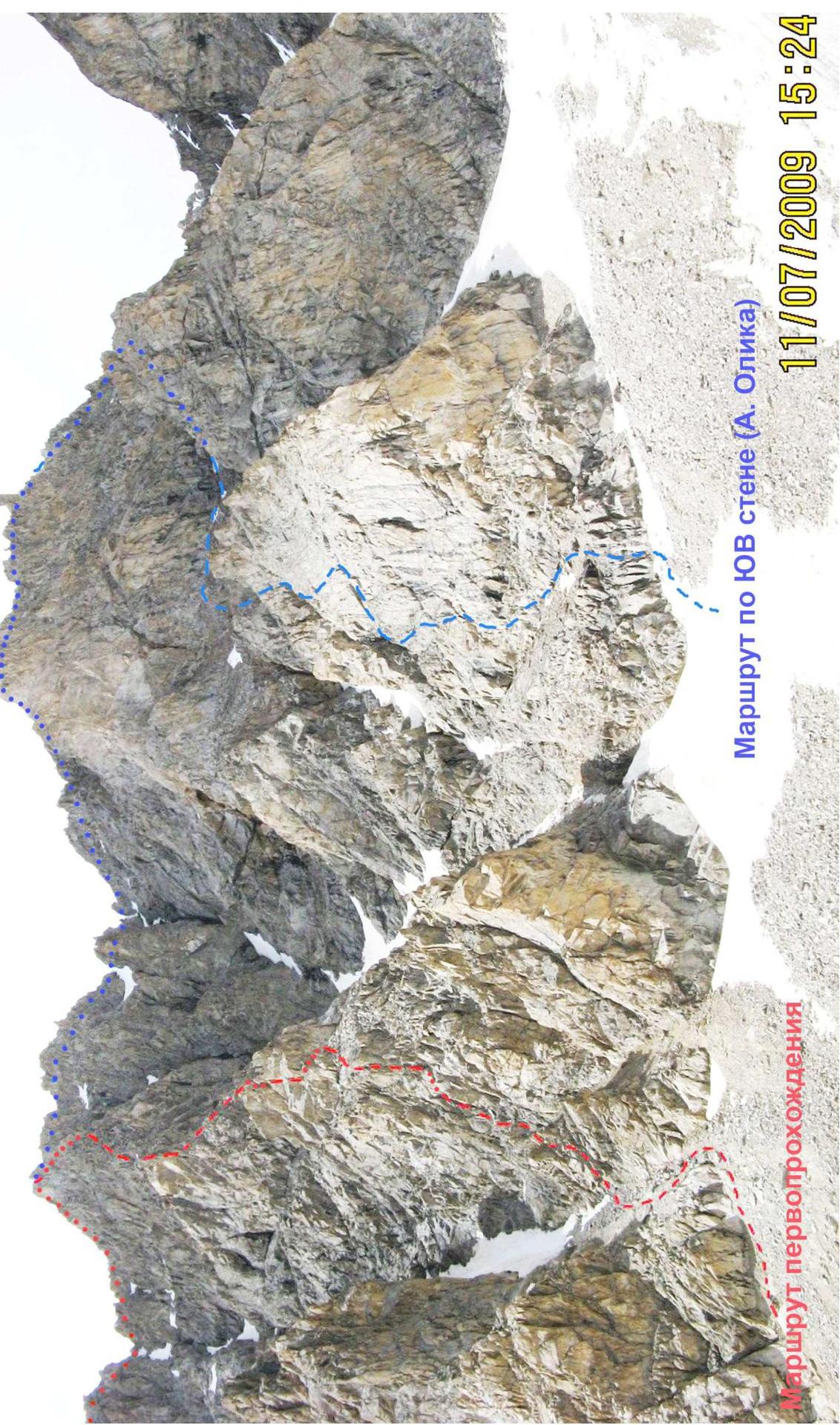
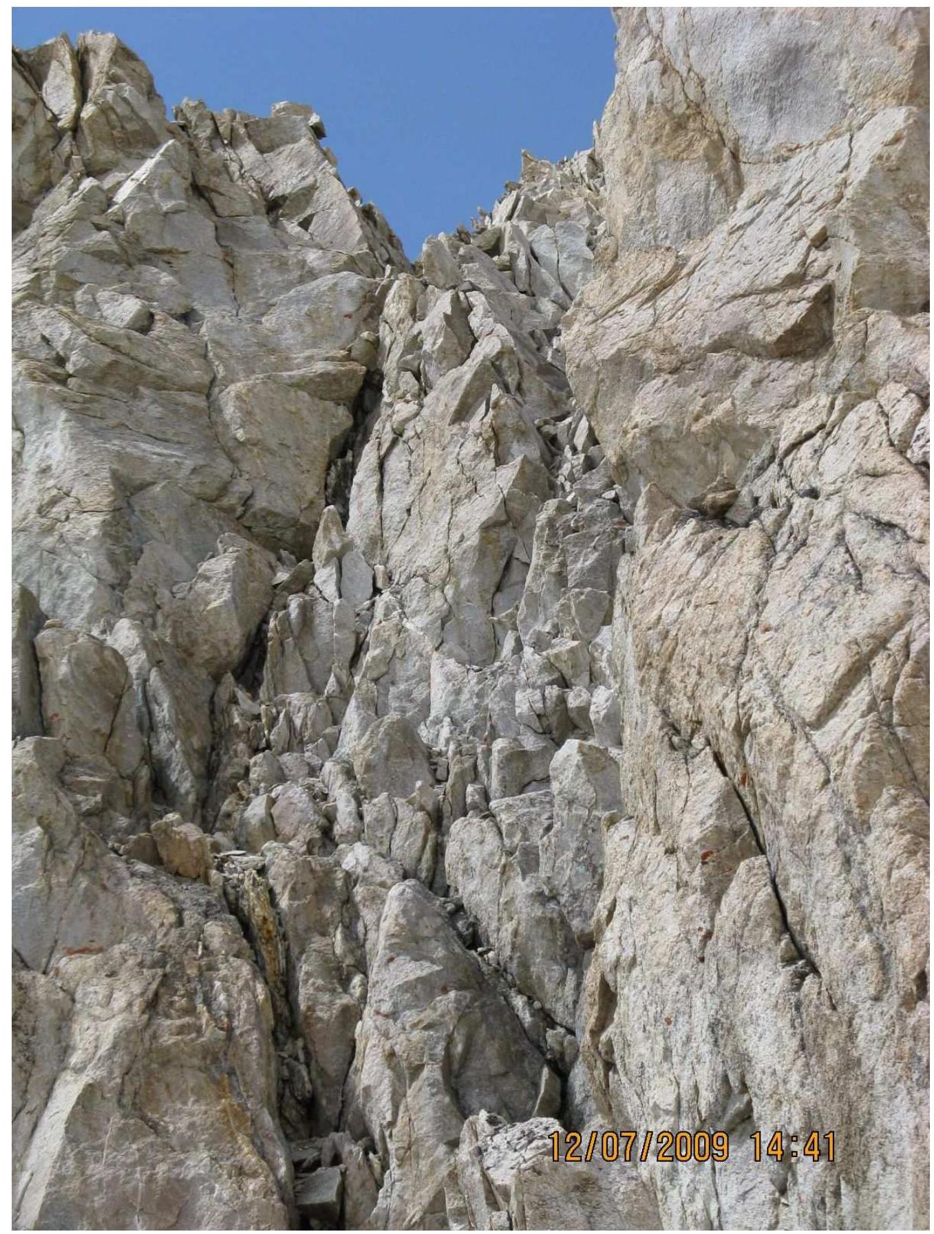
Photo 2. General view of the route.
Start of the wall part of the route.
Section 4–5.
Section 13–14.

Section 8–9. Bypassing the rock gendarme.
Section 14–15, start of section 15–16.
Section 20–21.