Report
On the first ascent to v. Khimik (3935 m) via the inner corner of the left part of the North-Eastern wall of the Northern ridge in the period from July 16 to 18, 2009 by the sports group of AUSB "Ullutau" consisting of:
- Nikolaev A.V. – leader
- Kabaev R.G. – participant
- Starykh A.N. – participant
AUSB "Ullutau" 2009
Addresses
AUSB "Ullutau" 361602, KBR, Nalchik, Tel. 8-8662-77-09-87
LEADER 300034, Tula, Klara Zetkin St., 3, apt. 204, Nikolaev A.V., home tel. 8-4872-55-41-32, E-mail: alexnik5@bk.ru
COACH 300001, Tula, Karl Marx St., 130, Rasskazov A.V., E-mail: tulalp@yandex.ru
Passport
-
Class of ascent – technical
-
Main Caucasian Range, Adyrsky ridge, spur Adyrsu-Treugolnik
-
Khimik peak, 3935 m, via the inner corner of the left part of the North-Eastern wall of the Northern ridge
-
Proposed 5A category of difficulty, first ascent
-
Height difference: 900 m Length: 1600 m Length of sections 4–5 category of difficulty: 250 m Average steepness of main sections: 70°
-
Number of pitons driven:
rock bolt chocks ice 0/0 0/0 42/0 15/0 -
Team's climbing hours: 14 (excluding descent) and days – 1
-
Overnight stays: 1 – on the summit
-
Leader: Nikolaev Alexander Vladimirovich, Candidate Master of Sports Participants:
- Kabaev Ravil Gennadievich, Candidate Master of Sports
- Starykh Alexey Nikolaevich, 1st sports category
-
Coach: Rasskazov Alexander Valentinovich, Master of Sports of the USSR
-
Departure on the route: July 15, 2009 Summit: July 17, 2009 Return: July 18, 2009
Brief overview of the ascent area
Khimik peak (3935 m) is located in the northwestern spur of the Main Caucasian Range (Adyrsky spur of the MCR or Adyrsky ridge). It is situated between Adyrsu (4370 m) and Ozernaia (3930 m) peaks.
The Adyrsky spur is considered the coldest place in the Adyrsu area.
According to the "Classification of routes to mountain peaks" by the Russian Alpine Federation, 2001 edition, the following routes are laid on v. Khimik:
- Training route 2B category of difficulty via the Eastern ridge
- Sports route 4B category of difficulty via the left rib of the Northern tower of the Northern ridge
- Sports route 5A category of difficulty via the North-Eastern wall of the Northern ridge
Map of the ascent area
Scale 1:100000
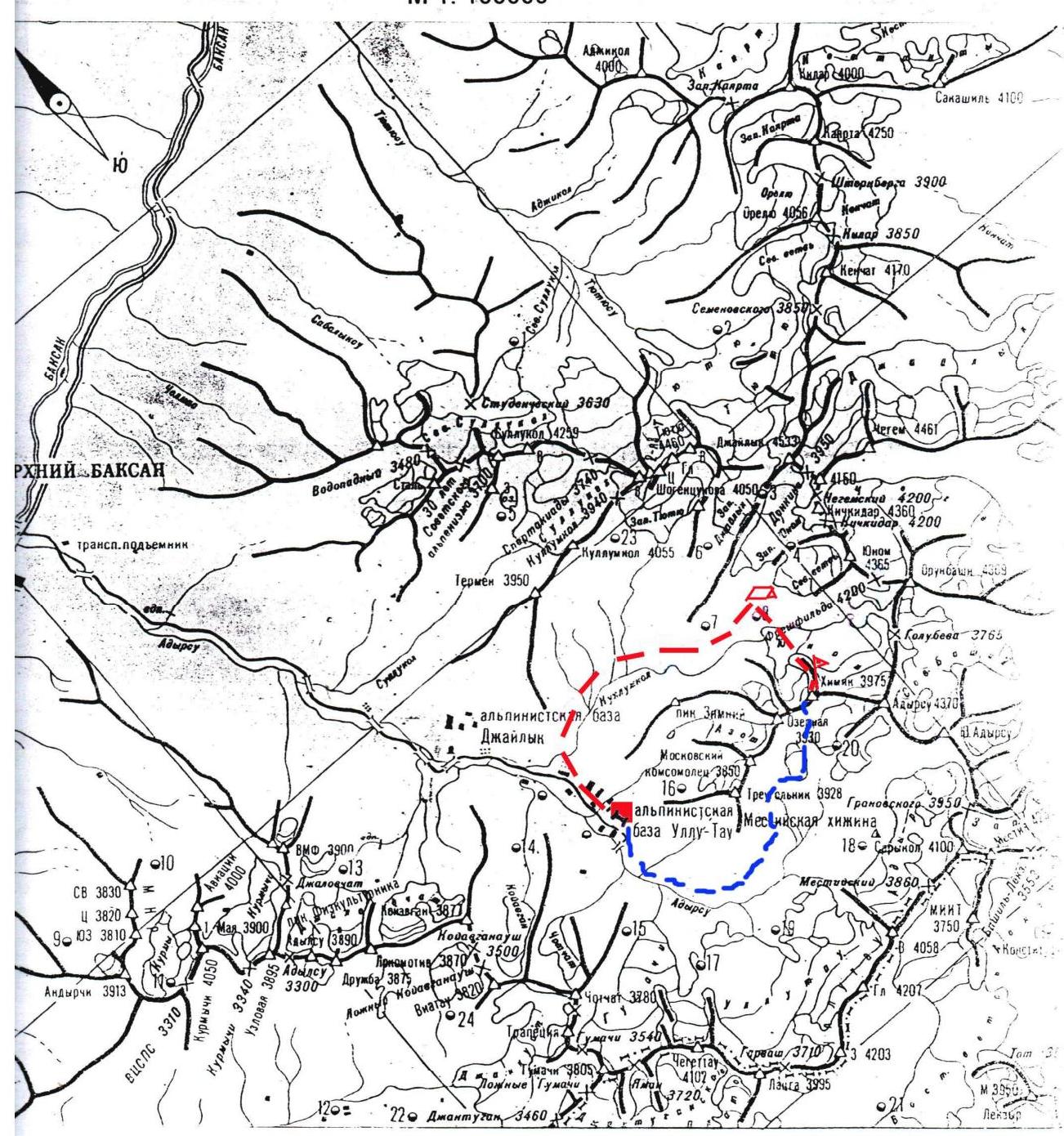
Conventional signs:
- AUSB "Ullutau" (red square)
- Middle Kickidarskie overnight stays (red arrow)
- v. Khimik (red triangle)
- approach path (red dashed line)
- return path (red dashed-dotted line)
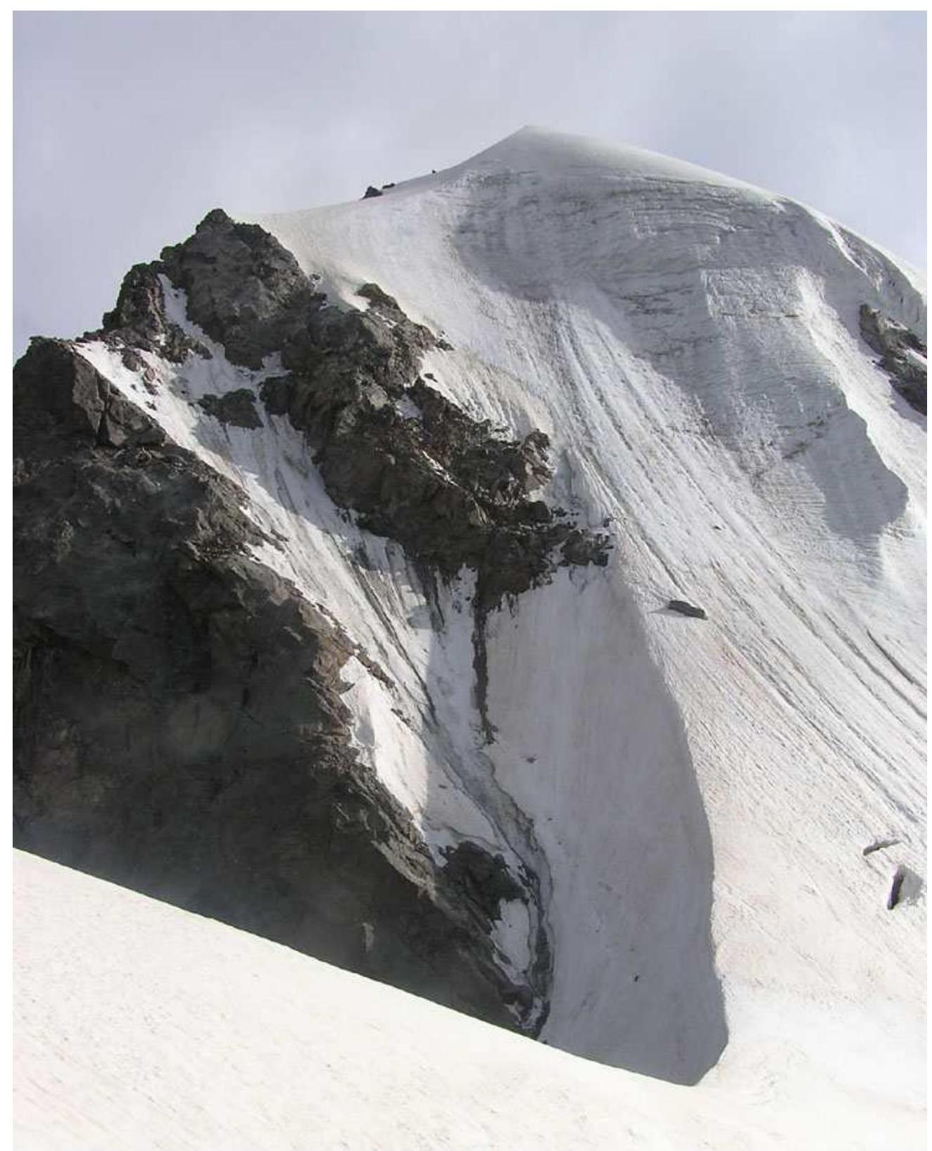
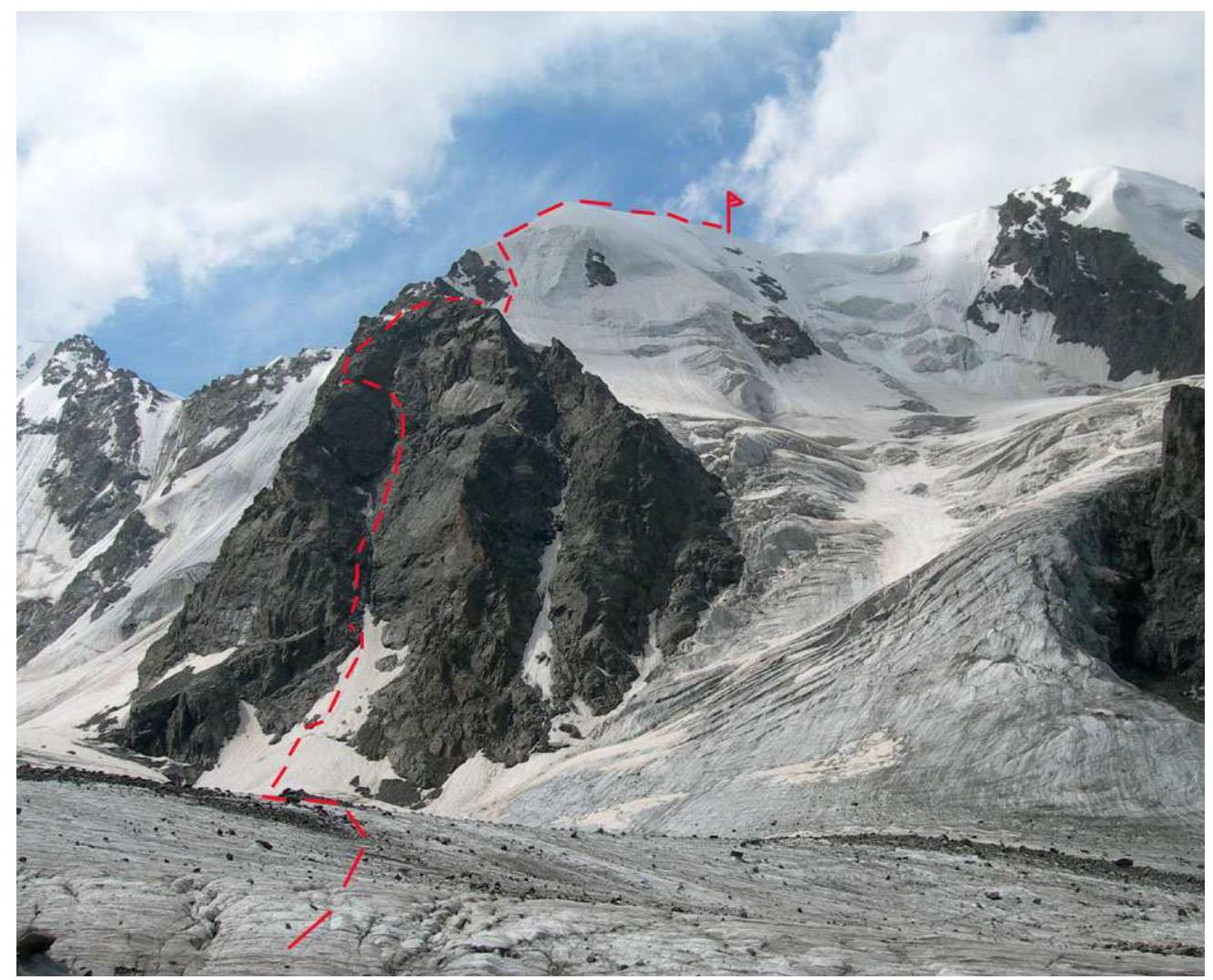 v. Khimik. General view of the route.
 View of the N-E wall of v. Khimik. Sections from R2 to R24
Route diagram in symbols
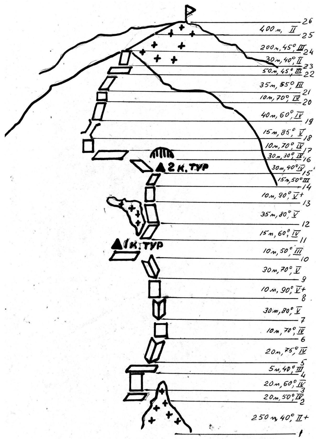
Profile diagram of the wall part of the route
Scale 1:2000

Tactical actions of the team
July 15, 2009. At 9:30, the team left AUSB "Ullutau" and at 13:30 arrived at the Middle Kickidarskie overnight stays, set up a bivouac. An attempt to approach the start of the route to scout the condition and clarify the path was thwarted by bad weather.
July 16, 2009. The whole day was spent at the bivouac due to continuous rain. Due to low cloud cover, visual reconnaissance of the route was impossible.
July 17, 2009. An early start on the route was not possible due to unstable weather. Only around 7:00 did the weather begin to improve, and it was decided to start the ascent immediately. Leaving the bivouac, the team crossed the glacier and at 7:50 approached the steep snowy ascent (section R1-R2).
Then, sticking to the left side of the inner corner, the ascent followed a system of oblique ledges and walls of medium and above medium difficulty to the base of the inner corner.
Then:
- 30 m of difficult climbing along the inner corner;
- 10 m along a very difficult wall;
- 30 m along a difficult inner corner to an oblique scree ledge.
1st control point. The team was at this location at 10:30.
Then, the team moved to the right side of the large inner corner and, via a system of steep, difficult walls (climbing 5), about 80 m long, reached an oblique ledge under the overhangs. 2nd control point. The team reached this point around 14:00.
Bypassing the overhangs on the left, the team reached a difficult, narrow oblique ledge. Along it, a traverse to the left and upwards.
In this place, there is a high risk of rockfall, so the first climber waited until the entire team gathered at the station at the start of the ledge.
The ledge ends in a 2 m deep pit. It can be descended into by climbing, and then:
- along the wall;
- along a very difficult chimney, 25–30 m.
Exit to the N-E ridge.
Then, along difficult and partly medium difficulty rocks, and in the upper part along simple and medium difficulty rocks (170–200 m), the team ascended to the flattening of the ridge. Exit to snow (18:00). Here, there is a platform suitable for organizing an overnight stay.
Since the further part of the route to the exit to the Eastern ridge was clearly visible, it was decided not to stop and continue moving.
Then, the team climbed a steep icy slope, about 200 m long (protection with ice screws), and then along a simple snowy ridge reached the summit of Khimik around 21:00.
The team set up an overnight stay under the summit at 21:30. July 18, 2009. The descent began at 8:00 via the 2B category of difficulty route towards Mestia hut. The team returned to AUSB "Ullutau" at 14:30.
Description of the route by sections
- R0–R1: 500 m, 15° — from the initial bivouac at the Middle Kickidarskie overnight stays, cross the glacier to the snowy ascent of the N-E wall of Khimik.
- R1–R2: 250 m, 40°, 2 category of difficulty. Ascent up a steep snowy slope to the base of the large inner corner.
- R2–R3: 20 m, 50°, 4 category of difficulty. Left and up along an inclined slab.
- R3–R4: 20 m, 60°, 4 category of difficulty. Up along an inclined wall of medium difficulty.
- R4–R5: 5 m, 40°, 3 category of difficulty. Right and up along an inclined ledge.
- R5–R6: 20 m, 75°, 4 category of difficulty. Ascent up a steep inner corner of medium difficulty.
- R6–R7: 10 m, 70°, 4 category of difficulty. Straight up along a destroyed wall.
- R7–R8: 30 m, 80°, 5 category of difficulty. Up along a difficult, steep inner corner.
- R8–R9: 10 m, 90°, 5 category of difficulty. Up along a very difficult monolithic wall to the start of a long, steep inner corner.
- R9–R10: 30 m, 70°, 5 category of difficulty. Ascent left and up along a difficult inner corner to a scree ledge.
- R10–R11: 10 m, 50°, 3 category of difficulty. Traverse left along a scree ledge. Control point.
- R11–R12: 15 m, 60°, 4 category of difficulty. Right and up along an inclined slab.
- R12–R13: 35 m, 80°, 5 category of difficulty. Ascent up a difficult, wet slab with a small number of holds.
- R13–R14: 10 m, 90°, 5 category of difficulty. Up along a very difficult wall.
- R14–R15: 15 m, 50°, 3 category of difficulty. Right and up along a destroyed oblique ledge under a large overhang. 2nd control point.
- R15–R16: 30 m, 40°, 4 category of difficulty. Left and up along a difficult oblique ledge.
- R16–R17: 30 m, 30°, 4 category of difficulty. Left and up along a difficult oblique ledge to a small two-meter pit and from it under a steep wall.
- R17–R18: 10 m, 70°, 4 category of difficulty. Ascent along a destroyed wall to the base of a chimney.
- R18–R19: 15 m, 85°, 5 category of difficulty. Up along a difficult chimney. Exit to the N-E ridge.
- R19–R21: 50 m, 60°, 4 category of difficulty. Ascent along a system of difficult slabs, walls, and inclined ledges.
- R21–R23: 85 m, 45°, 3 category of difficulty. Ascent along a system of walls and inclined ledges.
- R23–R24: 30 m, 40°, 2–3 category of difficulty. Up along a destroyed rocky ridge.
- R24–R25: 200–250 m, 45°, 3 category of difficulty. Ascent up a steep icy slope to the exit to a snowy ridge.
- R25–R26: 400 m, 20°, 2 category of difficulty. Ascent to the summit along a simple snowy ridge.
- Descent via the 2B category of difficulty route towards Mestia hut.
Brief verbal description of the route
The rocky bastion looks like three paws. The lower rocky part of the route passes through the inner corner between the central and left paws. The approach to it from the overnight stays goes along the glacier, and then along a steep snowy slope, 200–250 m long (a bergschrund is possible, which is bypassed on the left side).
From here, sticking to the left side of the corner:
- ascent along steep monolithic rocks, 70 m, to a wide scree ledge on the left — 1st control point;
- then along the right side of the corner, along the boundary of ice and rocks — ascent under an overhang in the upper part of a snowy-icy slope (live rocks);
- departure from the overhang on the right along the wall.
Then, along a not very steep inner corner to a large boulder, convenient for organizing protection. From it, along a wide, inclined 70-meter ledge, starting above the boulder, move left to the ridge of the counterfort. Then, the route goes along the counterfort. The first steep rocky ascent is bypassed on the left. The ridge consists of:
- short 5–7-meter walls;
- small ledges between them.
Then, along simple snowy slopes, the approach is made to the base of a snowy knife, along which the route goes via the left rib of the Northern tower, 4B category of difficulty. Along the snowy knife, turning into an icy wall, the ascent is made to the pad of an icy slope of the Northern ridge. Along the snowy Northern ridge, the ascent is made to v. Khimik.
Throughout the entire wall part of the route, there are difficulties in organizing famous protection.
Descent via the Eastern ridge and further along the couloir to the North Adyrsu glacier. Along the trail, through Mestia overnight stays to AUSB "ULLUTAU".
Photo illustrations of the route
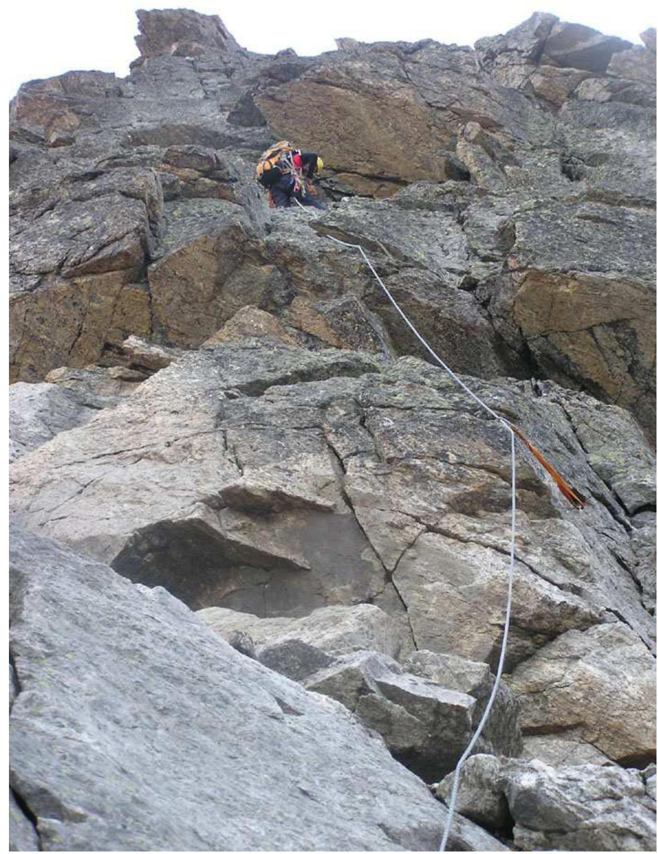
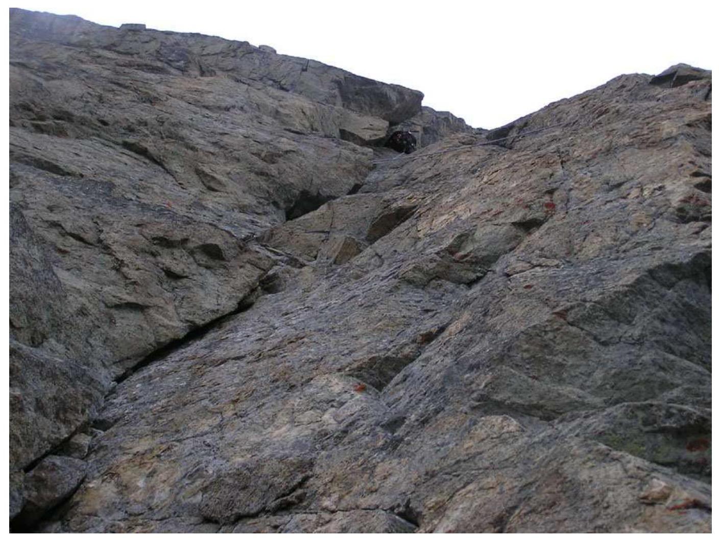 Section of the route R7–R8
 Section of the route R13–R14
 Section of the route R24–R25
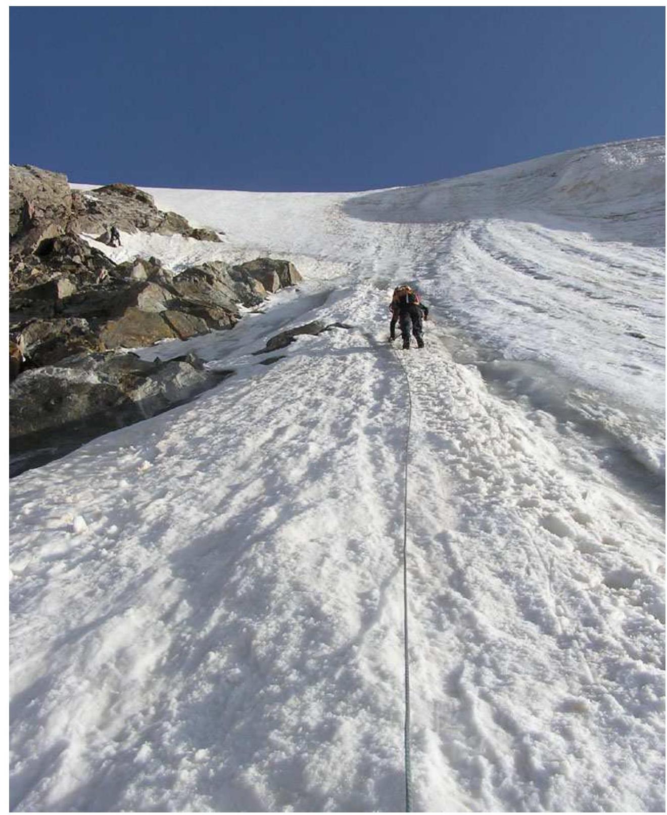
 Snowy-icy part of the route. Sections R24–R26
Route sheet (copy)
GOSKOMSPORT USSR ALL-UNION COUNCIL VDFSO TRADE UNIONS Appendix 13 "Compiled in 2 copies." ROUTE SHEET No. 76 For the ascent (hike) to v. Khimik via the route 5B category of difficulty under the leadership of Nikolaev A.V. consisting of 3 people. The ascent is organized by AUSB "Ullutau" 2009. The group's departure is permitted: (signature) (releasing coach) Date of release "15" July 2009. Agreed (signature of the camp commander, senior coach) The group is registered with the rescue team (exit plan agreed with KSP): AUSB "Ullutau" The control deadline for return is set for "15" July 198__ at 18:20 (position and signature) The group returned from the route "_" _______ 198 at "" hours "" minutes, having completed the ascent (hike) in the composition: (full, incomplete, F., I., O. not having completed the ascent) Instructions and comments from the releasing coach, rescue service:
Team leader (signature) Acknowledged: team leader (signature)
2. Group's equipment:
a) standard, additional, special equipment:
- main rope — 2 pcs.
- carabiners — 25 pcs.
- ice axes — 2 pcs.
- ice hammers — 2 pcs.
- ice screws — 0
- harness — 3 pcs.
- descent runners — 5 pcs.
- extension loops — 20 pcs.
- auxiliary rope — 1 pc.
- ice axes — 3 pcs.
- rock hammers — 0
- rock screws — 0
- crampons — 3 pcs.
- chocks — 42
- boxes, wedges — 15
b) bivouac equipment, clothing:
- personal equipment — 3 people
- first-aid kit — 1 pc.
- Pamiroka tent — 1 pc.
- rain cape — 3 pcs.
- sleeping bag — 3 pcs.
- down jacket — 3 pcs.
- protective helmets — 3 pcs.
- matches — 2 boxes
- candles — 2 packs
- stove — 1 pc.
- gasoline (in liters) — 2 l
- pots — 2 pcs.
c) communication, signaling means:
- radio station (type): HF + VHF
- flashlights — 2 pcs.
- radio station power supply — 1 set
- flares — 2 pcs.
- flare gun — 1 pc.
d) food supply:
- 3.25 kg × 3 people × 2 days
3. Plan of interaction, communication and signaling schedule with the base camp and other groups: (field not filled)
4. Options for ascent, descent, return from the route, other additional data: Descent via the 2B category of difficulty route.
Composition of group participants:
| № | F. I. O. | Sports category | Ascents this and last season (category of difficulty) | Climbing experience with whom, on what category of difficulty | Doctor's visa |
|---|---|---|---|---|---|
| 1 | Nikolaev A.V. | Candidate Master of Sports | 3, 12, 2/1, 0, 7, 19, 0 | with all 5B | |
| 2 | Kabaev R.G. | Candidate Master of Sports | 3, 12, 0, 4, 9, 0, 0, 0 | with all 5B | |
| 3 | Starykh A.N. | 1st sports category | 3, 8, 1/2, 1, 0, 6 | with all 5B |
The group is allowed to ascend in the number of 3 people. July 15, 2009. Doctor of the alpine event (signature) When preparing for the ascent, the group used materials: (field not filled) Consultation — from whom: (field not filled)
We, the leader and participants of the group, know the "Rules for conducting alpine events in the USSR" and measures to ensure the safety of mountaineering and take full responsibility for their observance during the ascent: Leader (signature) Participants: 1. Kabaev R.G., 2. Starykh A.N.
If necessary, all additional information is provided on separate sheets, ready-made diagrams and map diagrams are not redrawn.
Tactical plan of ascent, time breakdown, route sections, etc., route diagram in symbols.
- 15.07 – 13:00. Departure from AUSB.
- 16:00. Arrival at Middle Kickidarskie overnight stays.
- Reconnaissance, photography of the area.
- 16.07–17.07. Ascent completed.
- 18.07. Return to AUSB.
Table of contents
| Page | |
|---|---|
| 1. Addresses | 2 |
| 2. Ascent passport | 3 |
| 3. Brief overview of the ascent area | 4 |
| 4. Map | 5 |
| 5. Photo. General view of the peak | 6 |
| 6. Photo. View of the wall part of the route | 7 |
| 7. Route diagram in symbols | 8 |
| 8. Profile diagram of the wall part of the route | 9 |
| 9. Tactical actions of the team | 10 |
| 10. Description of the route by sections | 11 |
| 11. Brief verbal description of the route | 13 |
| 12. Photo illustrations of the route | 14 |
| 13. Route sheet (copy) | 18 |