ASCENT LOG
- Type of ascent — sport climbing. First ascent.
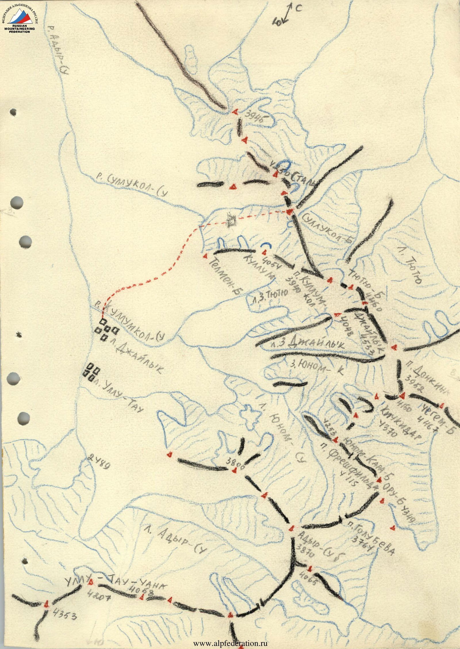
- Region of ascent — Caucasus, Adyrsky spur of the Main Caucasus Range.
- Ascent route with indication of peaks and their altitudes — Sullukol-bashi 2nd eastern peak via the South face, altitude 4259 m.
- Proposed category of difficulty — 4B cat. diff.
- Route characteristics: height difference — 510 m
average steepness — 47°
Length of sections:
- R1 — 80 m
- R2 — 60 m
- R3 — 100 m
- R4 — 100 m
- R5 — 50 m
- R6 — 120 m.
- Pitons hammered in:
for belay:
- rock — 27,
- ice — 0,
- bolt — 0; for creating artificial terrain (ИТО):
- rock — 1.
- Number of climbing hours — 14 hours.
- Number of bivouacs and their characteristics — 0.
- Surname, name, patronymic of the leader and participants, their sports qualification:
leader — Sitnikov Nikolai Nikolaevich, 1st sports category;
participants:
- Khatskevich Igor Georgievich, Master of Sports
- Korostylev Vyacheslav Aleksandrovich, 1st sports category
- Kuznetsov Vladimir Vasilievich, 1st sports category
- Team coach — Popov Viktor Pavlovich.
- Date of departure on the route and return:
departure from "Dzhailyk" alpine camp — June 21, 1977,
return to the bivouac under the Sullukol-su western glacier — June 22, 1977

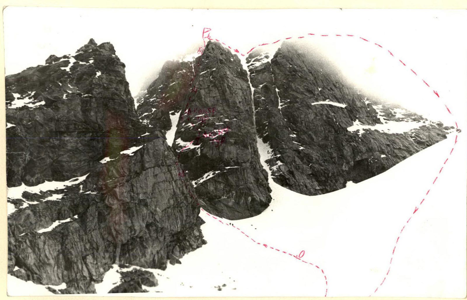

Description of the route to Sullukol-bashi 2nd eastern peak via the left part of the South face
From "Dzhailyk" alpine camp, we descend down the road. Not reaching the bridge over the Adyr-su River, we start ascending up the trail leading to the Sullukol gorge. Under the glacier, on the shore of a small lake, there are bivouacs.
The path from "Dzhailyk" alpine camp takes 3.5–4 hours.
From the bivouacs, we move:
- up the moraine to the Zapadny Sullukol-su glacier,
- across the glacier, leaving the slopes of the Kullumkal-bashi peak to the right, to the start of the route.
The route begins from the glacier. We ascend from the glacier via the left couloir with a steepness of 20–25° for about 80 m, to a wall that leads right to a ledge (R0–R1).
The first 8–10 meters:
- steep rocks (80–85°),
- complex,
- with a small number of cracks.
Further:
- along the ledge up and to the right,
- under the overhanging reddish tower.
Under the reddish tower — a control cairn (R1–R2).
From the control cairn, bypassing the tower, left-up along the ledge for about 40 m. At the end of the ledge — smooth rocks under the visible upper vertical inner corner. From the smooth rocks to the inner corner — a vertical section of about 15 m, then:
- at the base of the inner corner and up the inner corner — 3 m up,
- followed by an exit from it to the left onto monolithic smooth rocks,
- and up-left along them via an oblique cleft.
The section from the ledge to the end of the cleft is 100 m, climbing is complex.
Further:
- vertically up to a ledge (R2–R3).
- On the ledge — a control cairn.
- From the ledge — up under the overhanging rocks (20 m).
- Bypassing the overhanging rocks on the left, we move along the ledge with a large niche in the right part (very convenient place for a bivouac) to vertical rocks (R3–R4).
- Further up the snow with stones (6–7 m) up to vertical rocks and along them left-up through a fragment to monolithic rocks — exit to the ridge. Climbing is complex (R4–R5).
- Then we move along the ridge, consisting of simple rocks alternating with snow, to the summit (R5–R6). The section is straightforward.
Descent:
- right along the ridge to the second wide couloir,
- and down it to the Sullukol-su glacier.
Appendix 2
| Section characteristics | Designation of sections | Length in meters | Average steepness | Terrain characteristics | Difficulty | Condition of the section | Weather conditions | Rock | Ice | Bolt |
|---|---|---|---|---|---|---|---|---|---|---|
| Date | 2 | 3 | 4 | 5 | 6 | 7 | 8 | 9 | 10 | 11 |
| June 23, 1977 | R0–R1 | 80 m | 25° | snow | 1 | hard snow | satisfactory | 0 | 0 | 0 |
| R1–R2 | 60 m | 50° | wall and ledge | 5 | monolith | – " – | 3 | 0 | 0 | |
| R2–R3 | 100 m | 65° | complex rocks | 5 | monolith | – " – | 10 | 0 | 0 | |
| R3–R4 | 100 m | 40° | rocks of moderate difficulty | 3 | monolith | – " – | 4 | 0 | 0 | |
| R4–R5 | 50 m | 70° | complex rocks | 5 | monolith | – " – | 11 | 0 | 0 | |
| R5–R6 | 120 m | 15° | simple rocks with snow | 2 | snow-covered rocks | – " – | 0 | 0 | 0 |
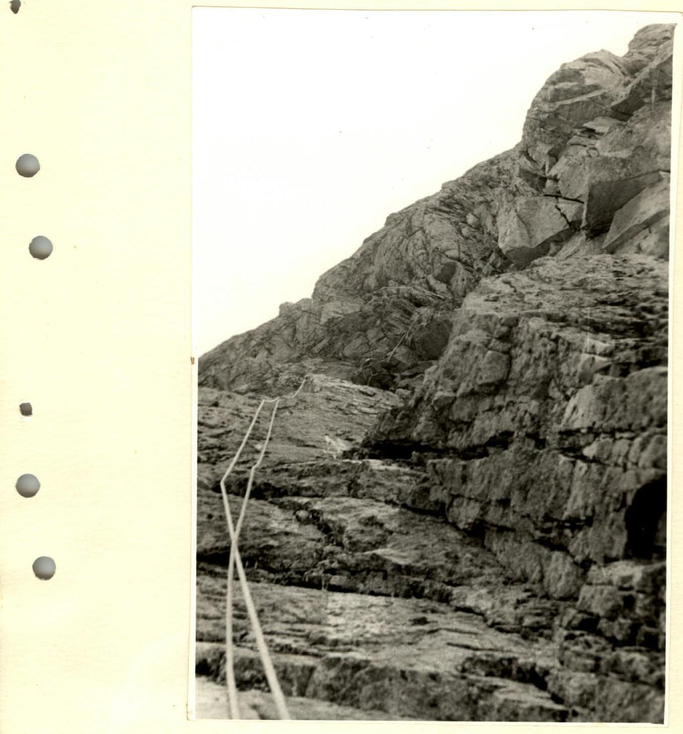
Section R4–R5