Ascent Passport (v. Treugolnik via NW ridge)
I. Ascent category — technical. 2. Ascent region — Central Caucasus. Leninsky Komsomol 3. Ascent route — Treugolnik peak (3620 m) via NW ridge, combined. 4. Ascent characteristics: elevation gain 800 m*. 5. Pitons hammered: rock — 6 ice — 0 bolts — 0 6. Duration of ascent — 11–12 hours. 7. Number of nights on the route — none. 8. Team name — instructors from "Dzhailyk" alpine camp. 9. Team members:
- Nevsky Alexander Vladimirovich, 1st sports category, leader.
- Vyazmin Stanislav Anatolyevich, — " ", participant.
- Shagurin Vitaly Ivanovich, — " ".
- Konovalov Vladimir Fedorovich, — " ".
- Bushuev Mikhail Konstantinovich, — " ".
- Titov Vyacheslav Semyonovich, — " ", 1st sports category.
- Team coach: Master of Sports of the USSR V. P. Popov.
- Dates of departure: June 20, 1976, return to camp: June 21, 1976.
*Measurements were taken using an altimeter.
REPORT on the ascent to Treugolnik peak via the Northwest ridge, category 2B (approx.).
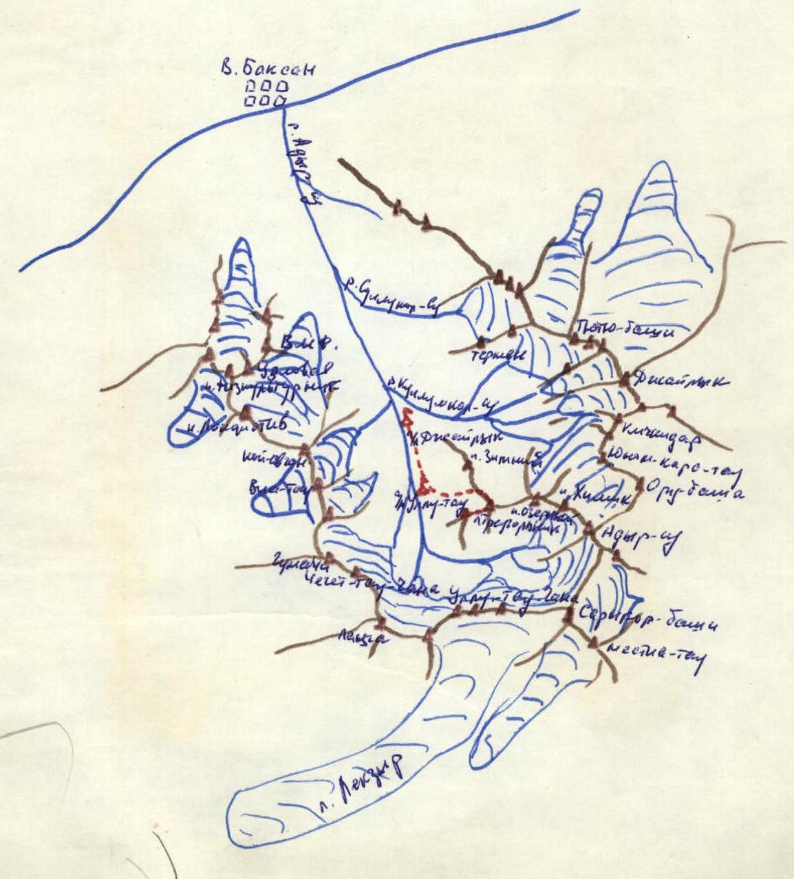
Treugolnik peak is located in the upper Adyr-Su valley, in a spur extending from Adyr-Su peak. It has a Southern ridge descending to Mestian bivouacs, classified as a category 1B route. To the east, a ridge leads to Ozerny peak, and to the northwest — to Panoramny pass. Since the Northwest ridge provides a logical ascent path to Treugolnik peak, it is reasonable to classify and recommend it for training and sports ascents.
ROUTE DESCRIPTION
The path from "Dzhailyk" alpine camp passes by "Ullutau" alpine camp and leads to the rock laboratory. Then, ascending straight up to the moraine and following the right edge, it crosses the moraine towards a wide snow- and ice-covered couloir, which leads to the middle of the Northwest ridge. Bivouac is possible in the upper part of the moraine in a small green depression where about 5 tents can be set up. From the camp to the bivouac site, 2.5–3 hours.
From the bivouac, ascend right-up to the moraine cone and from it — under the rocks of the wide couloir, which is over 100 m wide at its mouth. The ascent goes along the left side of the couloir, which rises 2–6 m above it and gradually merges with the slope of the Northwest ridge, via slabs and scree ledges to a snow saddle. From the moraine bivouac to the saddle, 2.5–3 hours.
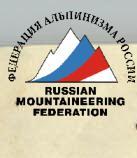
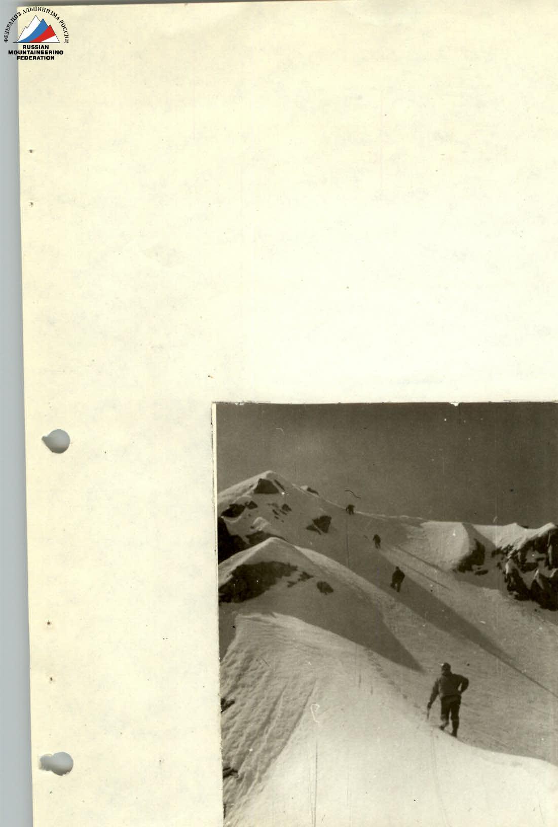
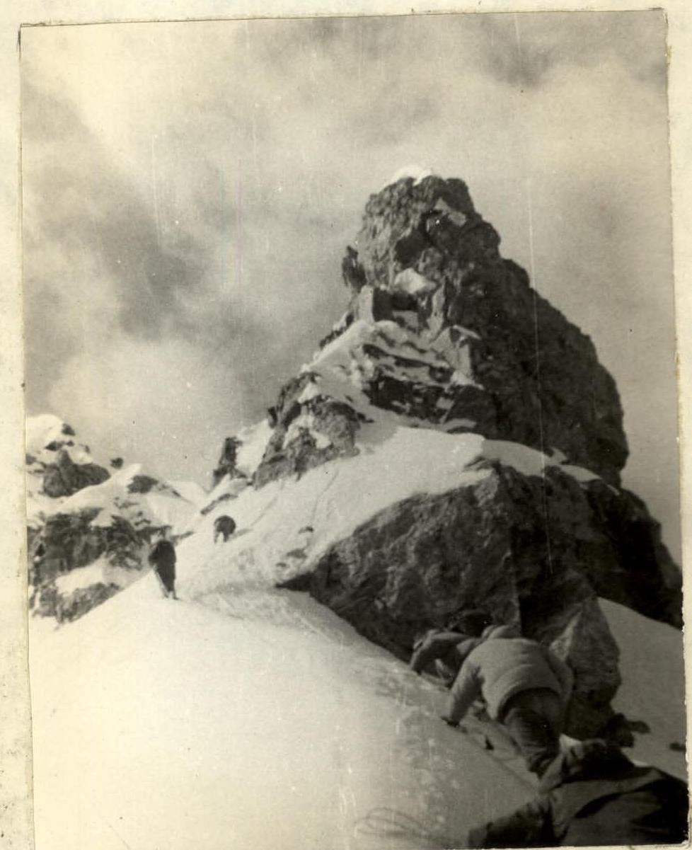
From the saddle, along the ridge, following the right side (scree ledges and slabs, covered with snow in June) via simple rocks, approach a gendarme. The gendarme is bypassed via a ledge on the left. Exit to the ledge via a 3-meter wall (pitons!). The ledge leads to an ice couloir, which exits onto the ridge. An ascent via a 6-meter wall (pitons!) is also possible, which also leads to the ridge (instead of ascending the 10-meter steep ice couloir). From the point of exit to the ridge, via a 40-meter snow slope with a slope angle of up to 50° (belay!), reach the Eastern summit of Treugolnik peak (Moskovsky Komsomolets peak), where a control cairn is located. From the saddle to the Eastern summit, 2.5–3 hours.
From the Eastern summit to the Central summit, a simple rocky ridge leads, above which several gendarmes rise. Ascend the I gendarme directly and descend from it in a sporty manner along a steep (50–55°) ridge to a narrow rocky saddle. From the saddle, ascend the 2nd gendarme directly via steep easy rocks, 20 m high (belay!). Then, along the ridge to the 3rd gendarme, which is bypassed on the right, and the 4th — on the left via narrow scree ledges (belay!) and exit to a simple rocky pre-summit ridge of the Central summit of Treugolnik peak. From the Eastern summit to the Central summit, 2–2.5 hours. Descent via the category 1B route or via the ascent path.
Route Table
Section R0 — from bivouac to the saddle on the ridge. Section R0 consists of two parts — approach to the couloir and the couloir. Average slope — 20–25°. Easy rocks, firn; length — about 1000 m; category 1 difficulty. Section R1 — from the saddle to the gendarme. Average slope — 20° (from 10° at the beginning to 30° before the gendarme). Firn, snow, simple rocks; length — 500 m; category 2 difficulty.
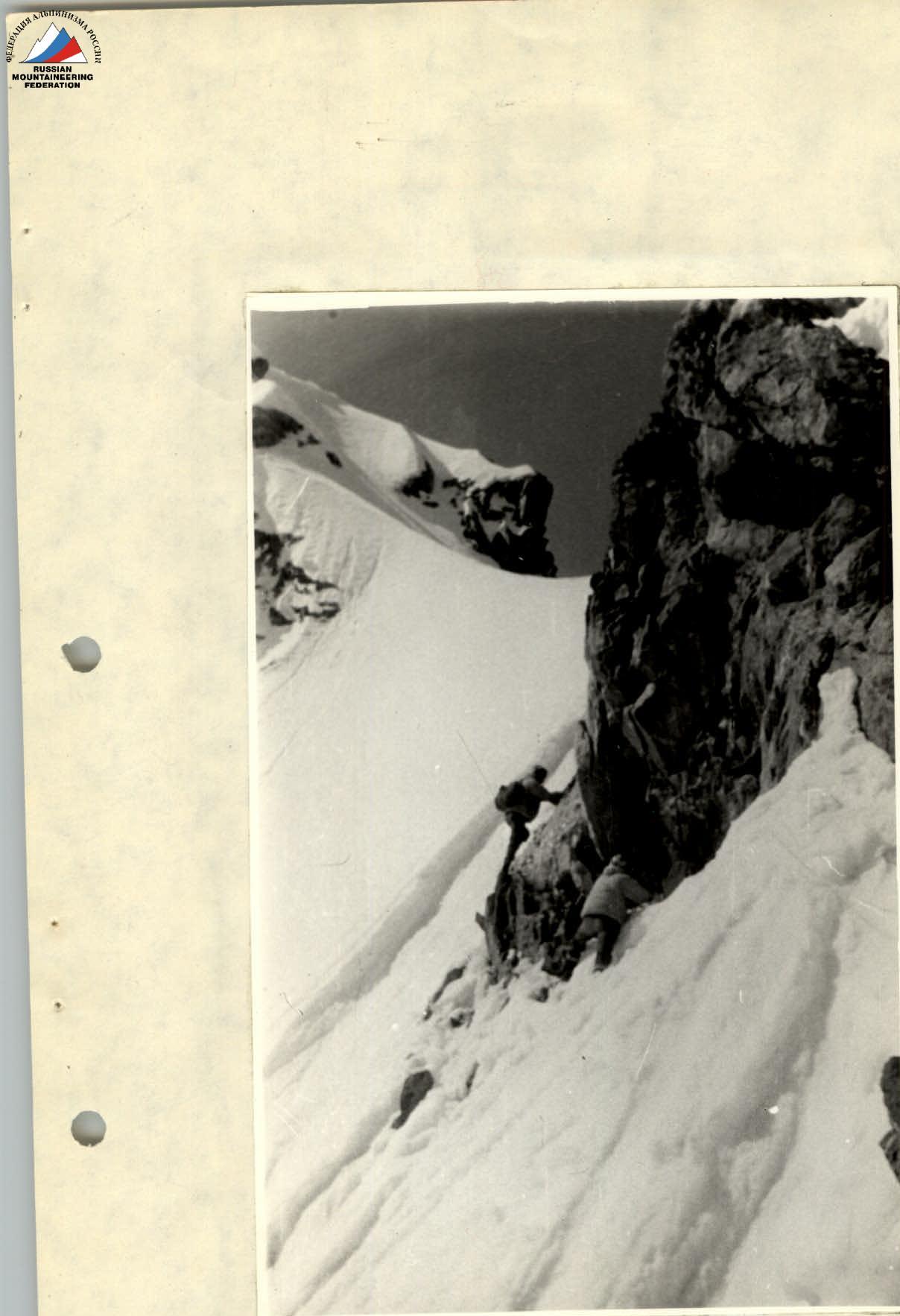
Gendarme
Bypass the gendarme on the left via a steep snow slope and diagonal ledges. Average slope — 55–60°; piton belay. Firn, rocks of medium complexity; length — 3–4 rope lengths; category 3 difficulty. Section R2 — from the gendarme to Moskovsky Komsomolets peak. Average slope — 40–45°, alternating belay via ice axe. Firn, rare outcrops of simple rocks; length — 300 m; category 2 difficulty.
Section R3 — between Moskovsky Komsomolets and Treugolnik peaks. (Numerous variations of the path along the ridge and gendarme bypass are possible). Average slope — traverse with minimal elevation gain, simultaneous belay via outcrops.
- Firn, snow, simple rocks.
- Length — 300 m.
- Difficulty category — 2.
Section R1
End of section R1 and approach to the gendarme
Bypass the gendarme. Approach to the wall.
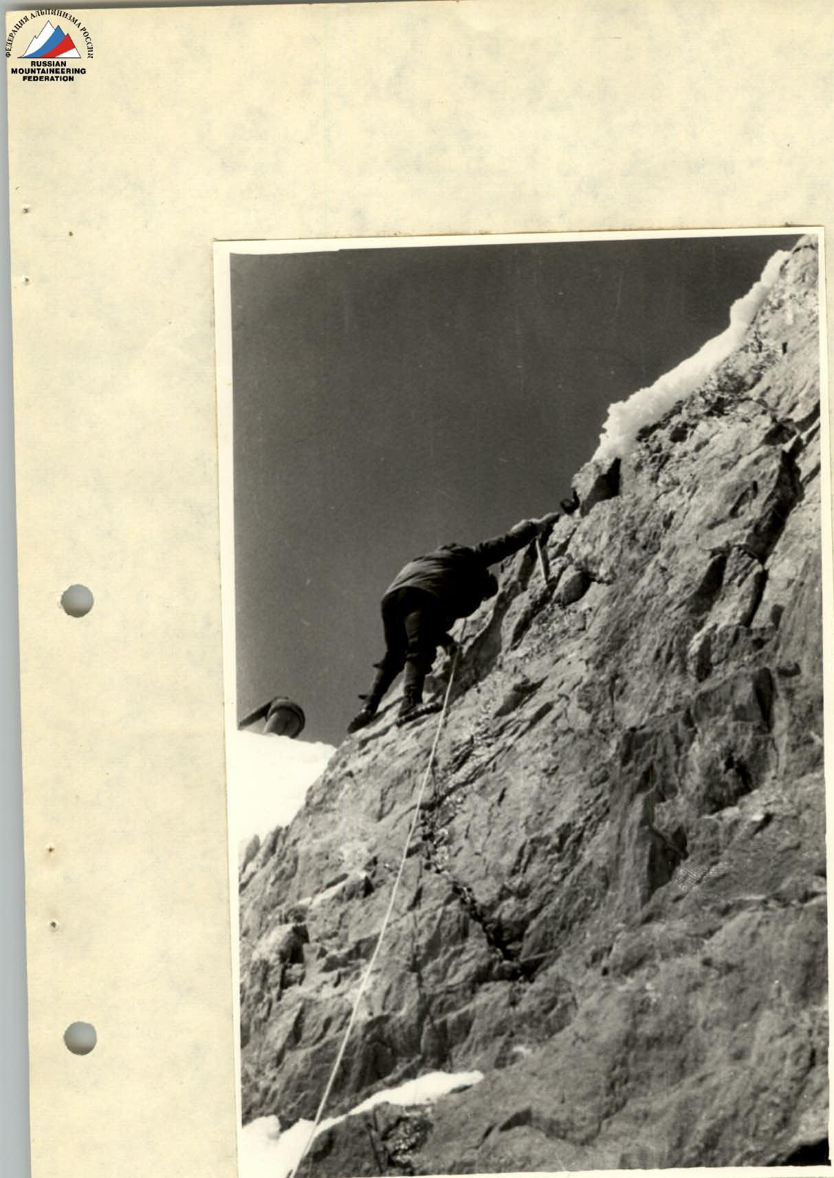
Gendarme wall.

Section R3 between Moskovsky Komsomolets and Treugolnik peaks