Ascent Passport
- ASCENT CLASS — rock
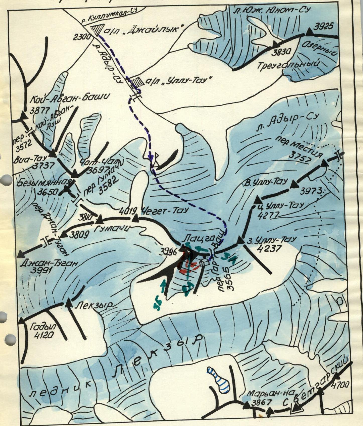
- ASCENT AREA — Main Caucasus Range between GARVASH and DZHANTUGAN passes
- PEAK, ROUTE — LATZGA (3996 m) via south-eastern counterfort
- EXPECTED DIFFICULTY CATEGORY — 4B
- ROUTE CHARACTERISTICS — rock, via counterfort, height difference — 455 m, average steepness 75°
- NUMBER OF PITS HAMMERED — 22 rock anchors, for belay
- NUMBER OF CLIMBING HOURS — from the start of the route to the summit 12.5 h
- NUMBER OF OVERNIGHT STAYS — no comfortable places on the route, one tent can be set up at I and II control sections
- ASCENT LEADER: Novikov S.A. — Pr
PARTICIPANTS:
- Chuenko S.A. — CMS
- Zaporozhchenko E.V. — CMS
- Karpinsky O.D. — CMS
- Melnikov V.I. — 1st sports category
- Samorezov V.L. — 1st sports category
- TEAM COACH — Damianiadi I.G. — MS
- DATE OF DEPARTURE ON THE ROUTE AND RETURN — 7–9 August 1980

Reference Scheme
Legend
- Approach path
- "Cheget" overnight stays
- Assault camp
- Directions: reported route and descent from the summit
- Classified (as of 1980) routes
The ascent to the summit of LATZGA, located in the Main Caucasus Range between the Garvash and Dzhangugan passes, was made from 7 to 9 August 1980 by a sports group from the "Dzhailyk" alpine camp in accordance with the route sheet (copy attached), preliminary description of the route, tactical plan and list of public and camping equipment taken by the group (documentation is in the files of the "Dzhailyk" alpine camp).
There are 5 classified routes to the summit of LATZGA (3996 m):
- via the southern couloir — 2A cat. diff.
- via the eastern ridge — 3A cat. diff.
- via the southern ridge — 3B cat. diff. (since 1980)
- via the eastern counterfort — 4B cat. diff. (since 1980)
- as part of the Chegettau–Latzga traverse — 3B cat. diff.
The first three routes start from the Garvash pass, the fourth — from a slightly lower point, to the west of the pass, but this route does not directly reach the summit, connecting with routes first 3A, and then 2A cat. diff.
Between the Garvash pass and the start of the 3B cat. diff. route, whose first ascent was made by a group of climbers from Pyatigorsk in 1979, there is a clearly defined counterfort of south-eastern exposure, which in its upper part turns into a narrow ridge, which in turn leads directly to the summit.
The route laid via the south-eastern counterfort does not intersect with any of the above-mentioned classified routes. It is also logical, like the 3B cat. diff. route (see diagram and photo of the general view of the route, where: on the diagram — routes 2A, 3A and 3B cat. diff., on the photo — 2A and 3B cat. diff.).
The group left the "Dzhailyk" alpine camp (2320 m) on 7 August 1980 in the direction of the "Cheget" overnight stays. Having passed them (2870 m), the group climbed to the Garvash pass (3560 m), where a camp — the assault camp — was set up in view of the counterfort.
* ) Below, all absolute elevations are given according to the altimeter readings. Exception — the summit mark, which has a geodetic reference on plans M 1:25000.
Reconnaissance of the route was carried out repeatedly both in 1979 and in 1980 and was carried out once again in the afternoon of 7 August 1980.
From the camp on the rocky destroyed ridge (the camp can also be set up on snow — in the hollow behind the pass), crossing the lower part of the ascent and descent southern couloir from the summit of Latzga of the 2A cat. diff. route and the base of the adjacent south-eastern couloir, via the glacier covered with firn (or snow, depending on the time of year), the path goes to a clearly defined counterfort against the background of the distant southern ridge (photo I).
The left lower part of the counterfort — a "striped" bastion (granitogneisses), ending in a rocky triangular "keystone" (photo 2). At the base of the bastion — a randkluft. Crossing it is difficult (belay). The starting point of the route begins immediately after the randkluft. Depending on its condition, the journey from the camp to point "0" will take from 0.5 to 1.5 hours.
Route Description
Section R0–R1. Up a narrow chimney limiting the "striped" bastion, on the right up to a small snow shelf 40 m. Steepness of the chimney 50°. There are loose stones.
Section R1–R2. From the shelf on the right, widest crack, on camming, vertically upwards 6 m to a narrow ledge. On it a few metres to the left to an internal corner with steepness of 35° with "live" stones. Up the internal corner to the left–up to a chip (30 m).
Section R2–R3. From the chip traverse left–up with a transition to the adjacent internal corner leading to the lower part of the crag — "keystone" (its inverted top). Difficult climbing 30 m under a chimney with a "plug", steepness 80°.
Section R3–R4. The "plug", after which the internal corner forks, is left to the right. On insignificant ledges difficult traverse to the left 5 m (handrail on piton belay for subsequent roped parties). Further movement to the left–up with exit to the summit part of the bastion. Climbing is difficult 35 m. Absolute elevation — 3660 m. I control section. A narrow ridge 8–10 m leads to the destroyed right walls of the main counterfort (photo 3).
Section R4–R5. Along the ridge to the destroyed wall. On the wall with insignificant ledges, on piton belay, taking a few steps to the left, transition to the south-facing side of the counterfort. After 30 m of difficult climbing–under an overhang, which is bypassed on the left with an exit to a "balcony". Above the "balcony" straight up 10 m to a relatively wide shelf. From the shelf to the left–up on one of the numerous internal corners difficult climbing about 40 m to a stepped series of scree destroyed shelves, above which to the left–up goes a wide, expanding in the middle part to the size of a grotto, chimney.
Section R5–R6. From the shelves to the right–up on a steep internal corner very difficult climbing 40 m. Then 60 m to the right–up on difficult, in places smooth rocks, to a short section of the southern ridge of the counterfort. The "Central" couloir remains on the left all the time. Only after reaching the ridge can you see that two daughter couloirs branch off from the "Central" one (to the right), but they are also very steep.
On the ridge — II control section. Absolute elevation — 3840 m.
Section R6–R7. From the control section to the right along the ridge, which has a steepness of 45°. On the ridge there is snow, many "live" stones. Gradually it becomes steeper and after 60–80 m it rests against a wide destroyed wall with a number of zigzagging internal corners. Ahead is a visible gap — a jumper in the main south-eastern ridge, to the right of which are two gendarmes. The path should be directed towards the jumper.
To the wall, along the ridge, the section is relatively simple. Further 30–35 m of difficult climbing, steepness 75–80° (photo 4).
Section R7–R8. From the rocky jumper–gap ascent 20 m with overcoming a difficult vertical 5-metre wall with a crack on a gendarme in the ridge. Further on the northern side of the gendarme, after about 10 metres, ending in a 10-metre wall, to a narrow snowy jumper with stones. The wall can be climbed by climbing.
Absolute elevation — 3910 m.
Section R8–R9. From the snowy jumper on the rocky slope with a steepness of 45°, 100 m, to the summit. Here the movement can be simultaneous — this is the simplest section of the route (photo 5).
Descent from the summit by the known 2A cat. diff. route.
The group started the route at 6:00 on 8 August. They were at the summit at 18:30 on the same day. A camp was set up in a snow-ice hollow before the descent couloir. The group returned to the assault camp on the Garvash pass at 8:00 on 9 August, and on the same day — to the "Dzhailyk" alpine camp.
All group members had ascents to the peaks of the region: "Stal" and "Khimik" on routes 4B cat. diff. and therefore could give a comparative assessment of the newly passed route. The latter is logical, all bypass options (after section R0–R1) are more complicated. When passing it requires accuracy: spontaneous descent of stones is not observed, however, in the choice of ledges for belay (numerous) should be cautious.
Rocks: gneisses, granite-gneisses, crystalline schists.
There are numerous opportunities for using chocks, the required set of rock anchors — standard (VTsSPS), anchors with a channel section go well.
Movement — on a double rope, except for section R8–R9 and short sections after I and II control sections, only alternate.
Places for overnight stays:
- relatively comfortable — under the summit
- uncomfortable, but possible — on I and II control sections
The protocol of the analysis of the ascent and a brief preliminary description of the route were submitted to the training department of the "Dzhailyk" alpine camp and to the KSP of the Adyr-Su region.
Recommendations
- The number of participants more than 4 people is undesirable
- When moving, use a double rope
- In the set, in addition to the usual VTsSPS anchors, have anchors with a channel section, chocks, jammers for moving on handrails.
Leader Novikov (S.A. Novikov)
Table of main characteristics of the ascent route to the summit of LATZGA on a route of approximately 4B cat. diff.
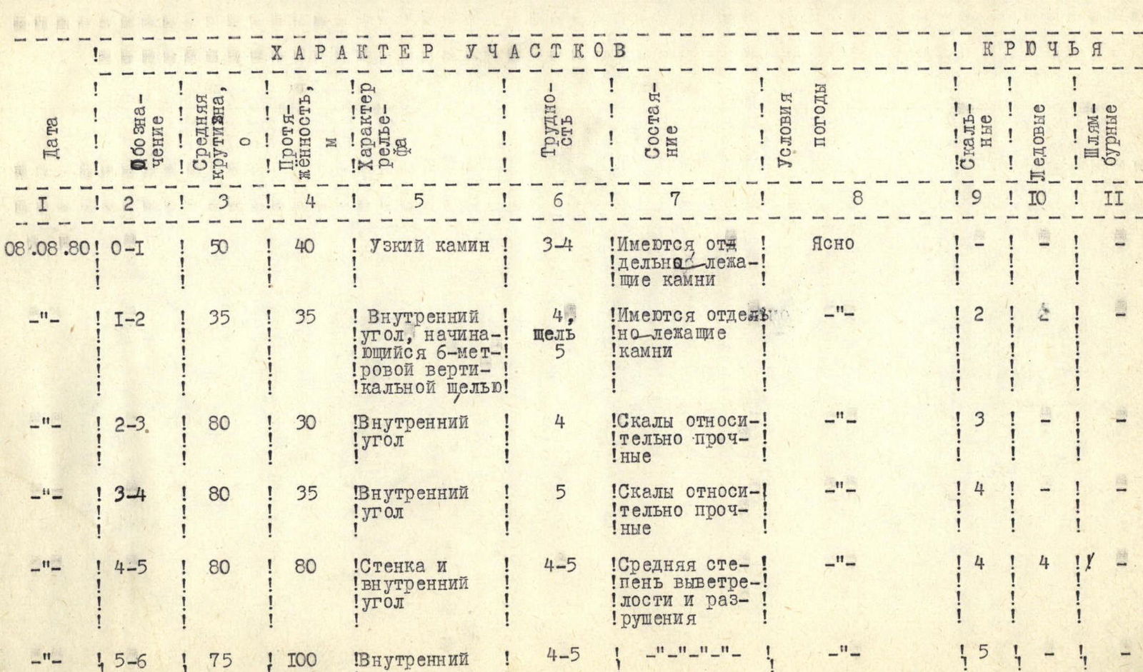
Note: On the route, in addition to belay and self-belay using anchors and ledges, chocks were also used.
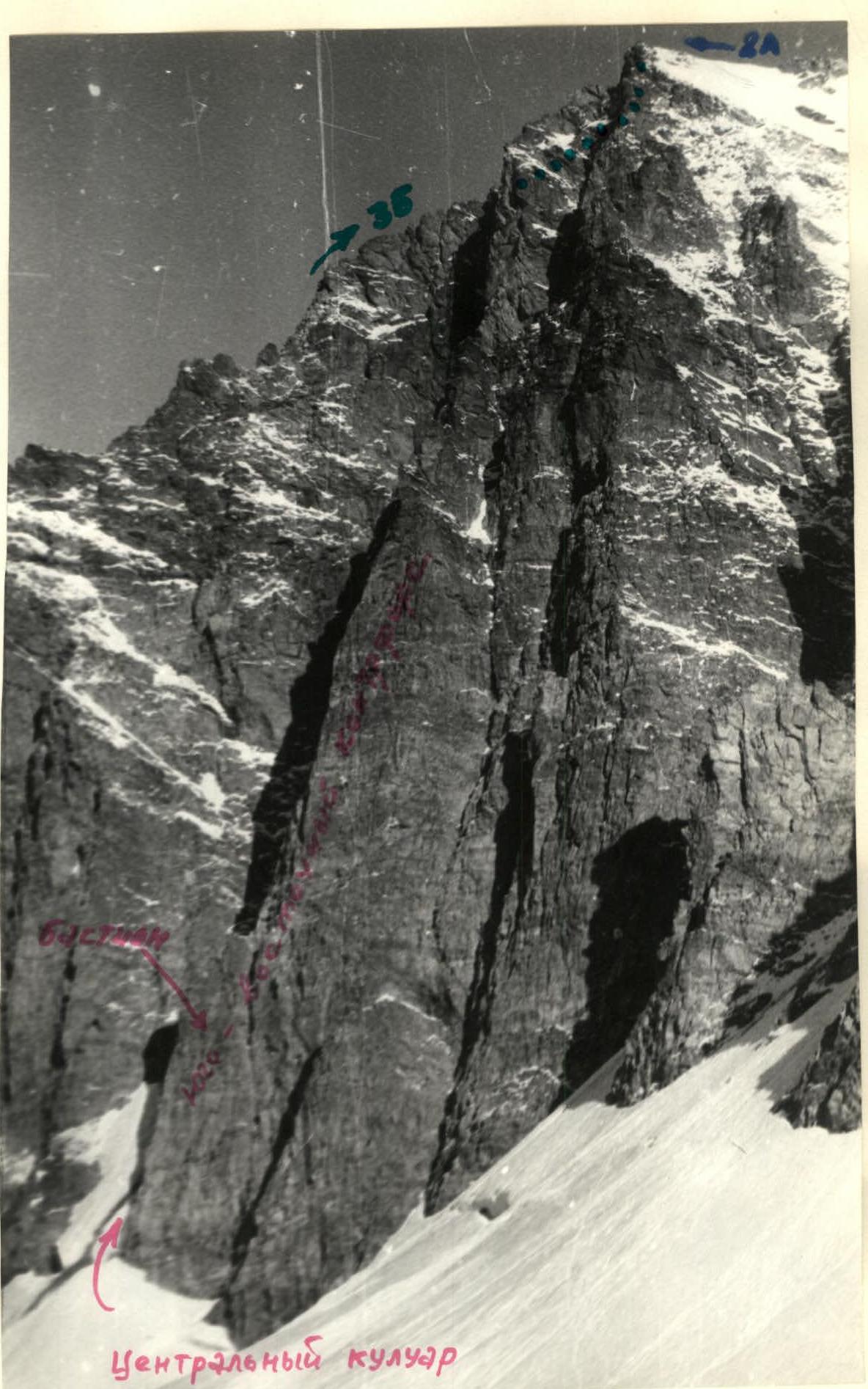
Photo 2. General view of the south-eastern counterfort of Latzga from the camp

Photo 3. Passing the "striped" bastion. Sections R0–R4
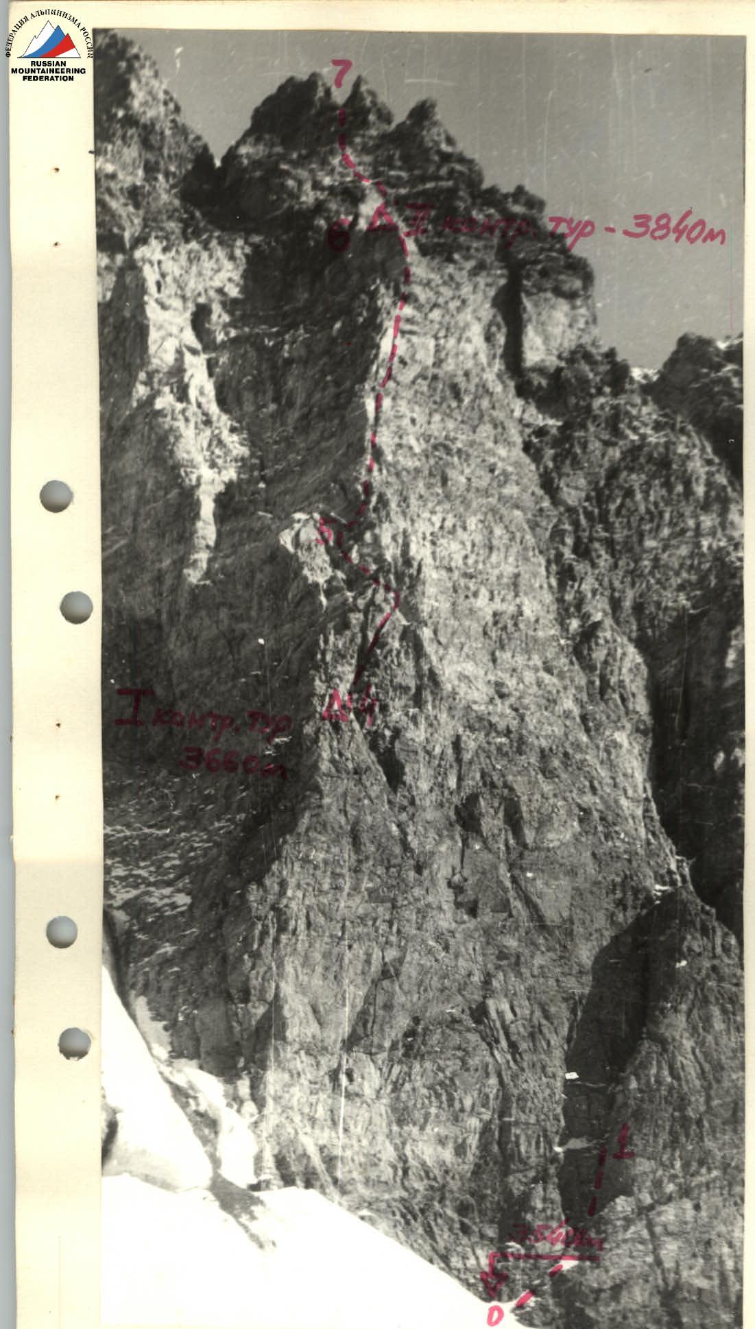
Photo 5. View of the sections from the Garvash pass Photo 4. View of sections R4–R7 from the south


