
Ascent Passport
- Ascent class: technical
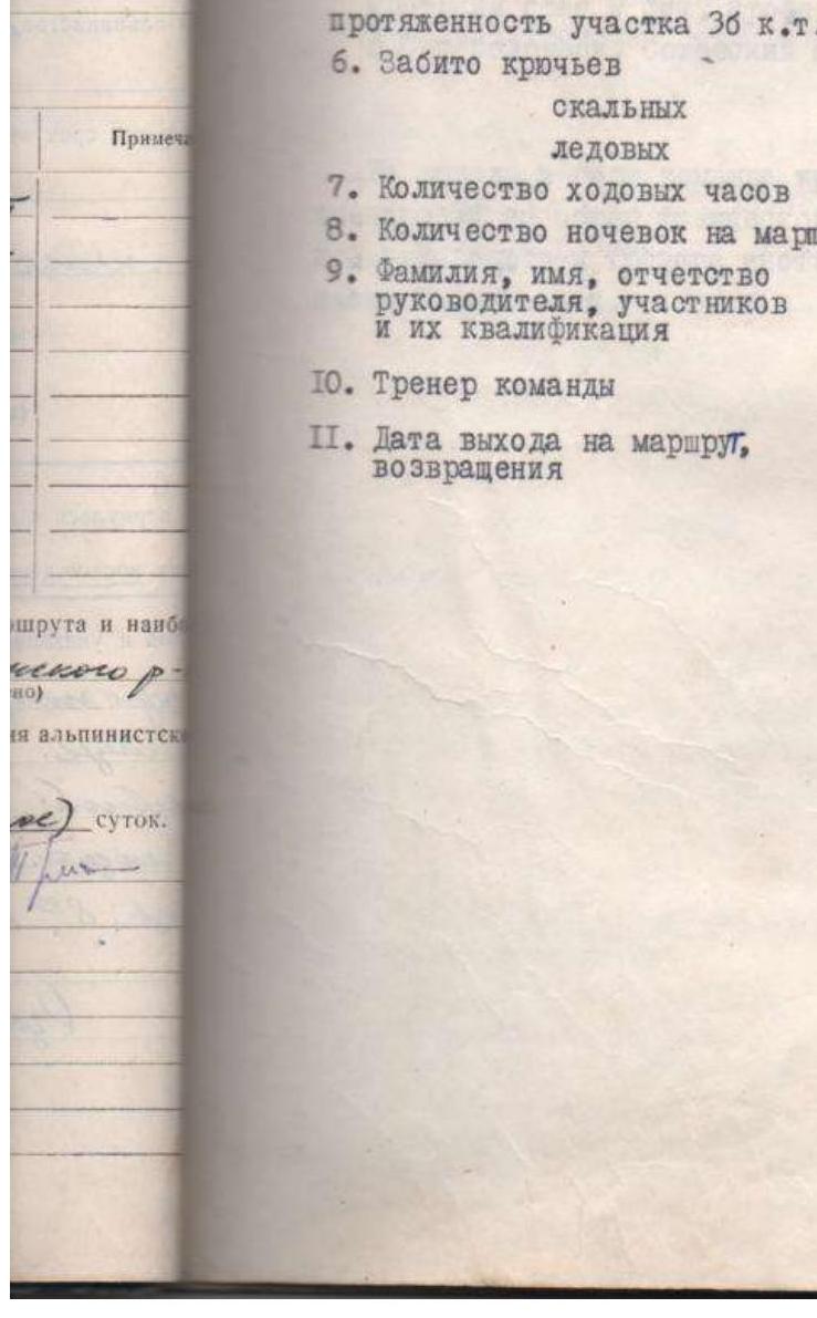
- Ascent area: Caucasus, Gvandra district, Kichkinekol gorge
- Peak, its height, ascent route: S. Dolomit, 3710 m, via the Western ridge
- Proposed difficulty category: approximately 3B cat. diff.
- Route characteristics:
- Height difference: 700 m
- Average steepness: 35°
- Length of section with 3B cat. diff.: 250 m
- Pitons driven:
- Rock: 10
- Ice: 10
- Number of climbing hours: 7 h
- Number of nights on the route: –
- Surname, name, patronymic of the leader, participants, and their qualification: Bulgakov Gennadiy Yuryevich (1st sports category), Tkachenko Aleksey Petrovich (1st sports category)
- Team coach: Optov Afanasiy Savelyevich
- Date of departure on the route, return: Departure from base camp on July 28, ascent and return to base camp on July 29, 1980
Dolomit 3710 m
Description of the first ascent to the North peak via the Western ridge, 3B cat. diff. (Bulgakov G.Yu., Tkachenko A.P.)
August 28, 1980
From a/l "Uzunkol" along the left bank of the Kichkinekol river to koshi. From here, left of the stream, along the trail up to the second large green terrace – bivouac site – Dolomit overnight stays.
From the camp 2.5–3 hours.
August 29, 1980
From the bivouac along the trail up to Dolomit lake. From the lake along the scree left up to Okhotnichiy pass.
From the lake 40–50 minutes.
Section R0–R1: from Okhotnichiy pass along the western ridge of S. Dolomit peak, leaving the yellow gendarme on the left, 40 m simultaneous movement under an inclined 10 m slab. The slab is climbed along its left part (alternate movement). Belay point after 15 m from the slab, then inclined slabs with numerous cracks, slab inclination along the route — left. Climb in the right part of the slabs closer to the ridge. From the belay point, the length of the section along the slabs is 40 m (pitons belay). Here is the I control tour.
Section R1–R2: from the control tour descent into a dip 20 m.
Section R2–R3: from the dip along the yellow wall in its left part via a crack (climbing 4th category, pitons) up 25 m. It is possible to organize reception of participants belay and reception of group participants. Then right up 3 m under overhanging blocks and along slabs 60–70° under the base of a chimney. Chimney 6 m (the entire section from the dip — pitons belay). The chimney leads to the top of a gendarme, descent from the gendarme 10 m into a dip. From the dip along large blocks straight up 40 m under a 50-meter wall, cut by cracks and fissures.
Section R3–R4: The wall is climbed along its central part in the direction of a break on the wall's top. 7 m before the break, go right up, leaving an internal corner on the left, along a slab 70–75° via a crack in it to the ridge. The ridge edge is steep. Along the ridge straight up to a yellow overhanging ledge, which is left on the right. Here reception of the remaining group participants (pitons). 20 m after the overhanging ledge, exit to the ridge, along the ridge straight up and along a 20 m wall (steepness 45°), bypassing a large stone in the upper part of the wall on the left, go to a 30-centimeter crack in width between two breaks. The crack is climbed without handholds. Exit from the crack is difficult. Then simultaneous movement along the ridge 150 m in the direction of a white wall.
Section R4–R5: The white wall is bypassed along a horizontal wide ledge (40 m) right in the direction of a counterfort, formed by the white wall and southern slopes of the ridge. Then straight along the counterfort 40 m under an overhanging white break (key location, pitons). From the overhanging break, move 3 m into an internal corner with steepness 75–80°, length 20 m with exit to the main ridge. 10 m after the internal corner under a large stone II control tour.
Section R5–R6: From the tour along the ridge, bypassing a gendarme on the right under a heavily destroyed wall. The wall is 40 m, steepness 70–75°, climbed via a crack. Left of the crack, yellow stones overhang. 10 m later, the crack turns into a 2-meter chimney. From the chimney straight up to the ridge.
Section R6–R7: Then along the ridge in the direction of yellow gendarmes. These gendarmes are bypassed on the right and without loss of height along scree slopes in the direction of a heavily destroyed ridge, exit to the summit.
The path from the pass to the summit took 7 hours.
Descent from S. Dolomit peak along the ridge, then along scree slopes under the ridge, leading to Okhotnichiy pass, and along short couloirs, all the time bearing right, under the proper slopes of the pass. Along them down to Dolomit lake and along the trail down to the bivouac.
From the summit to the bivouac 1.5 hours.
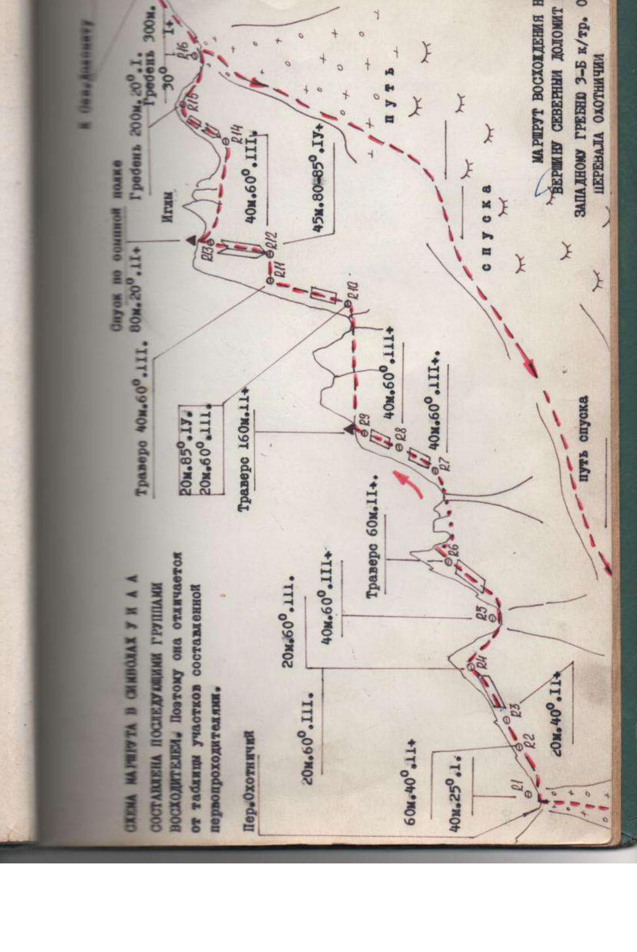
Route diagram in UIAA symbols
Compiled by subsequent groups of climbers. Therefore, it differs from the table of sections compiled by the first ascenders.
Route of ascent to North Dolomit peak via the Western ridge, 3B cat. diff. from Okhotnichiy pass.
Okhotnichiy pass:
- 20 m, 60°, 3
- 20 m, 60°, 3
- 60 m, 40°, 2+
- 40 m, 25°, 1
- 20 m, 40°, 2+
- 20 m, 40°, 2+
Descent along the aspen ledge:
Trawl 40 m, 60°, 3. 80 m, 20°, 2+. Ridge 200 m, 20°, 1. 20 m, 85°, 4. 20 m, 60°, 3. Trawl 160 m, 2+. 40 m, 60°, 3+. 40 m, 60°, 3+. 40 m, 60°, 3+. 45 m, 80–85°, 4+. 45 m, 80–85°, 4+. 40 m, 60°, 3+. 40 m, 60°, 3+. 40 m, 60°, 3+. 20 m, 40°, 3. Descent path.
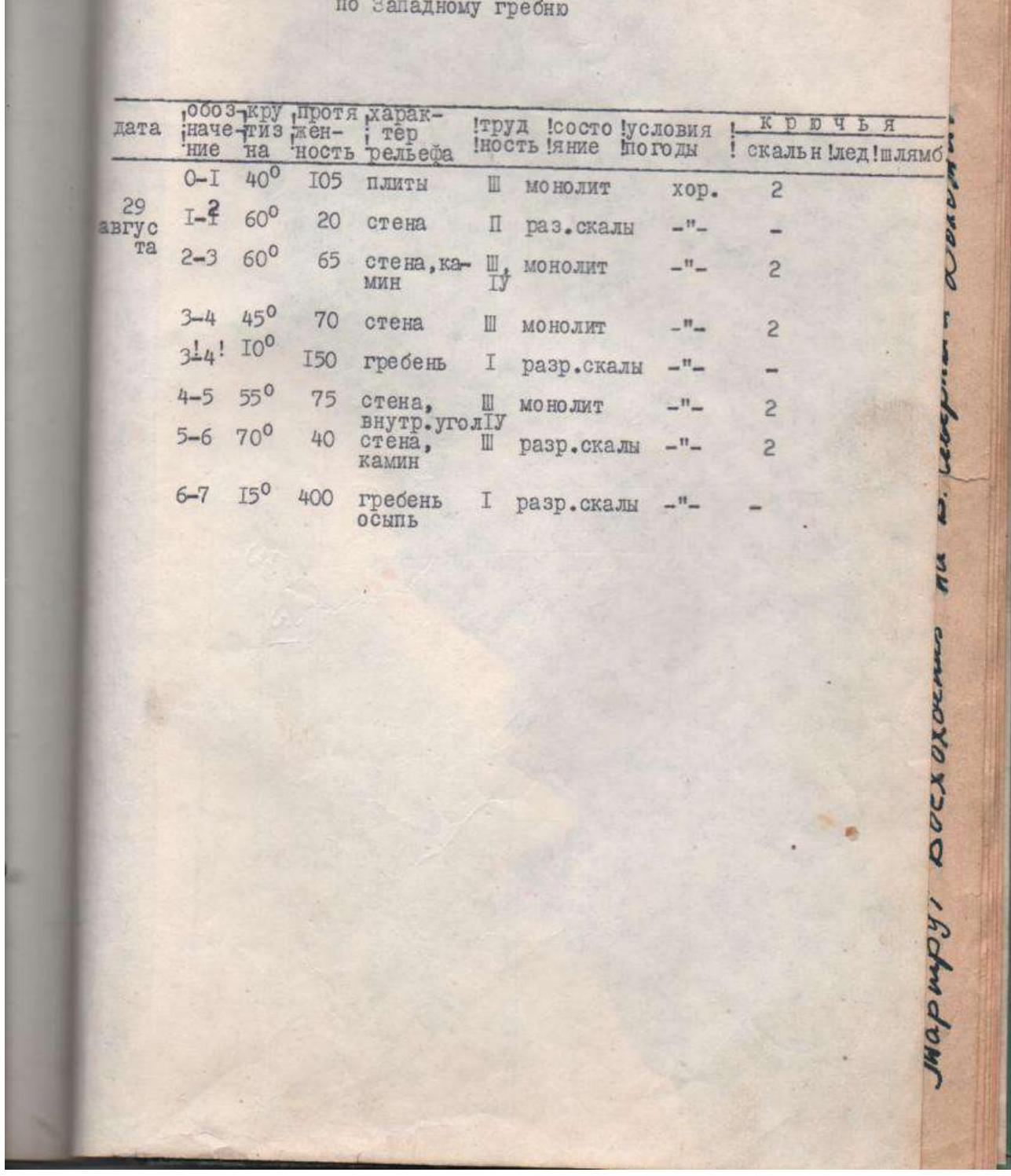
Table of main route characteristics
First ascent to v. S. Dolomit via the Western ridge
| Section | Steepness | Length | Relief characteristics | Difficulty | Weather conditions | Pitons (rock) |
|---|---|---|---|---|---|---|
| R0–R1 | 40° | 105 m | slabs | 3 | good | 2 |
| R1–R2 | 60° | 20 m | wall | 2 | – | 2 |
| R2–R3 | 60° | 65 m | wall, chimney | 3 | – | 2 |
| R3–R4 | 45° | 70 m | wall | 3 | – | 2 |
| R3–R4 | 10° | 150 m | ridge | 1 | – | – |
| R4–R5 | 55° | 75 m | wall, internal corner | 4 | – | 2 |
| R5–R6 | 70° | 40 m | wall, chimney | 3 | – | 2 |
| R6–R7 | 15° | 400 m | ridge, scree | 1 | – | – |
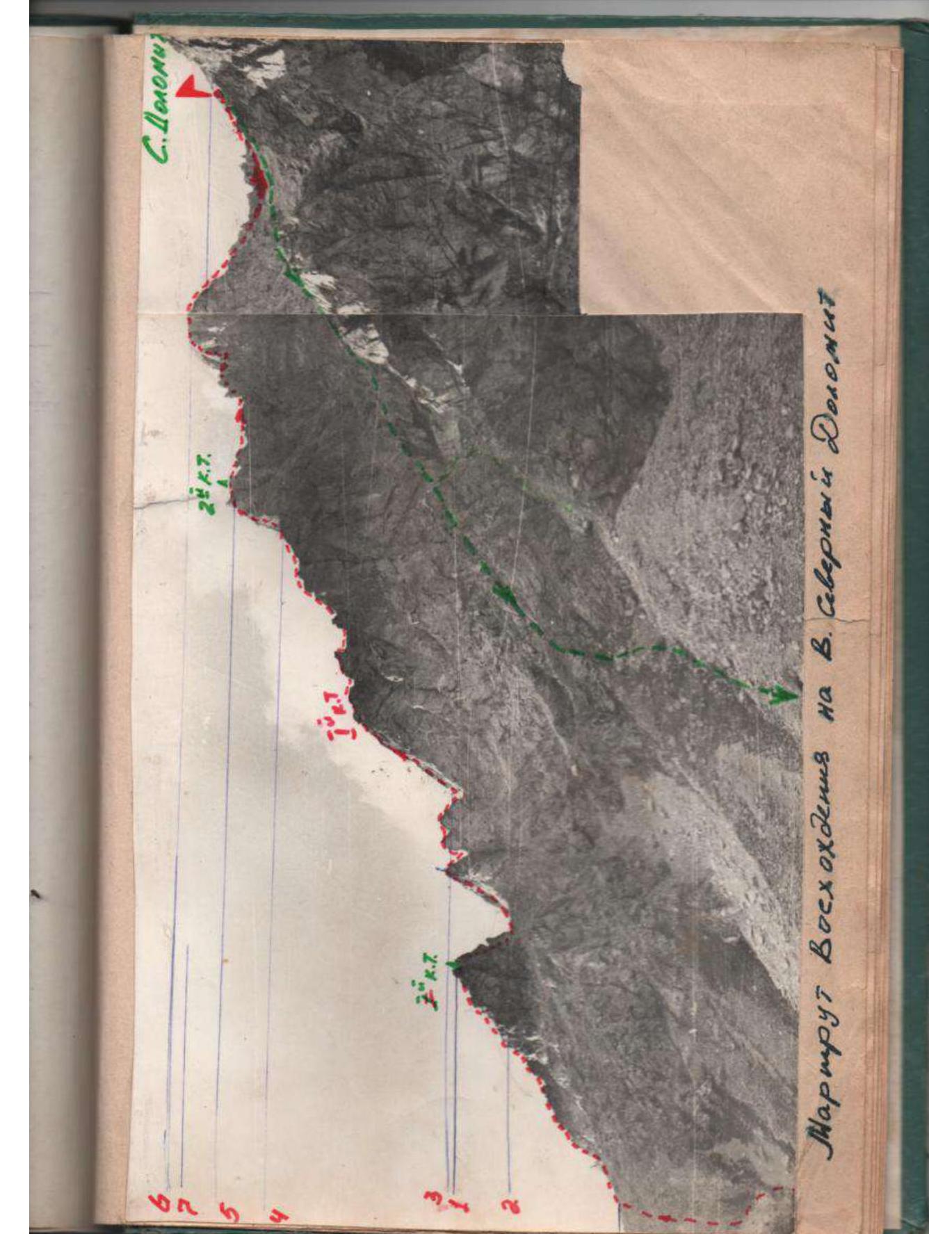
Route of ascent to North Dolomit peak
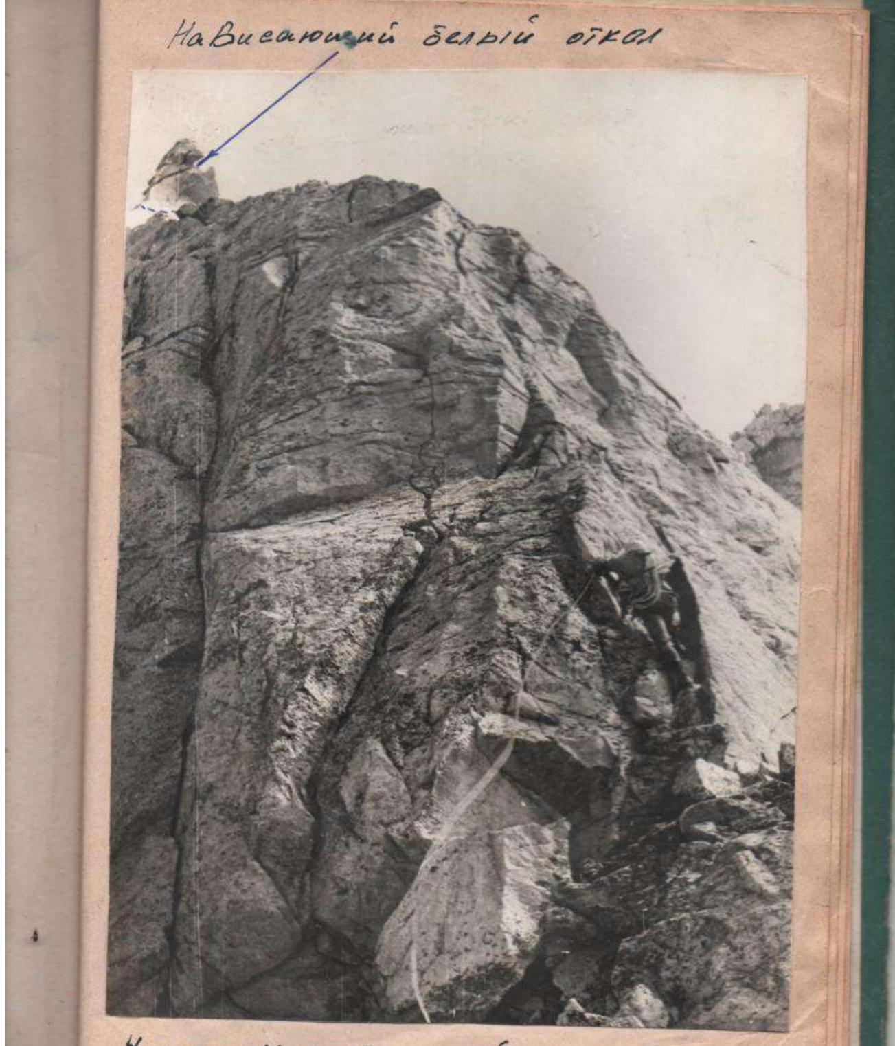
Overhanging white break
Section R4–R5 in its lower part
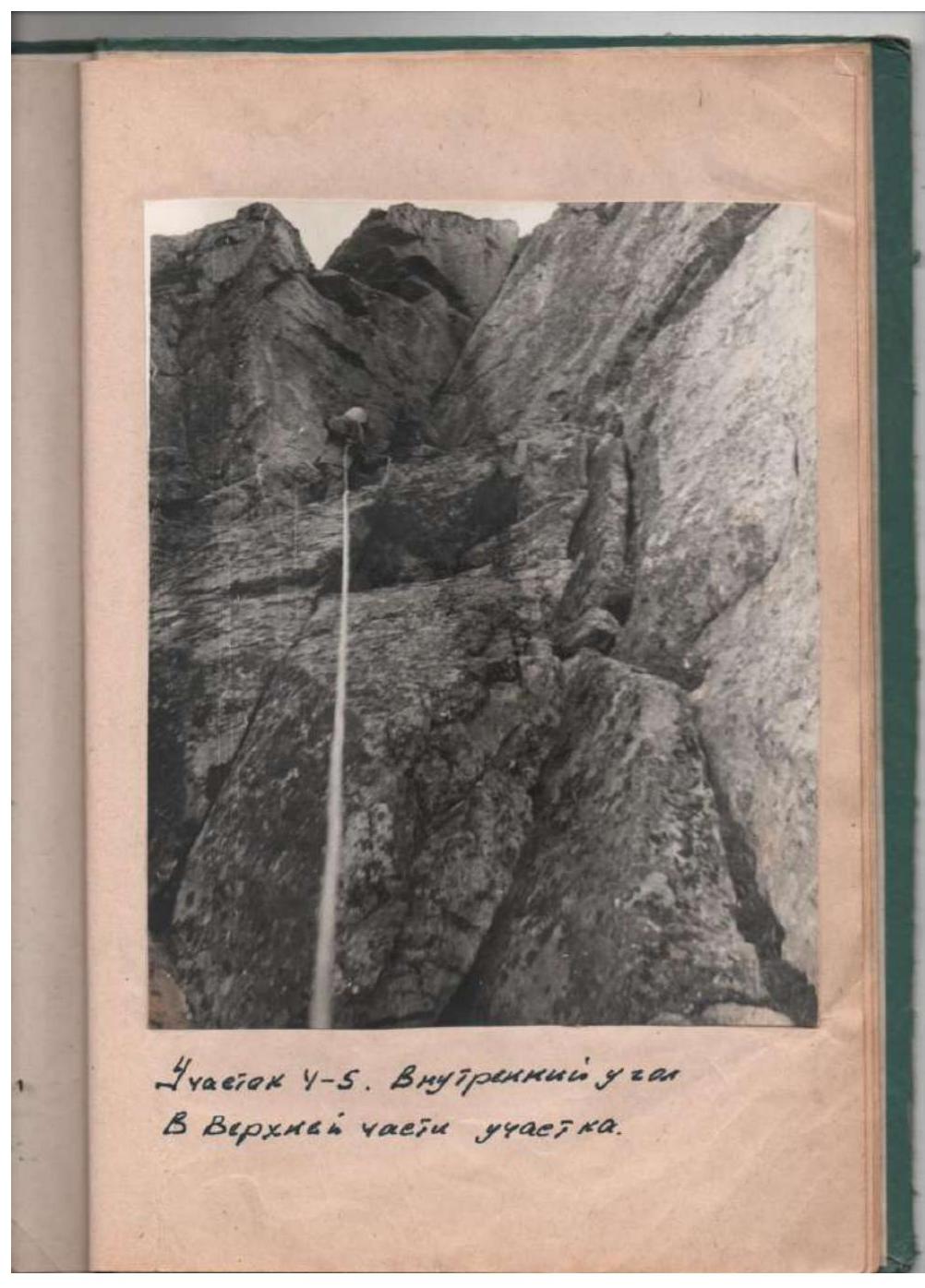

Comments
Sign in to leave a comment