Ascent Passport
I. Ascent category: rock 2. Ascent area: tourist center "Uzungol", Western Caucasus 3. Ascent route: peak CHAT-BASHI 3760 m, northern edge
-
Proposed category difficulty: 4B
-
Route characteristics: height difference 860 m, average steepness 50–55°
-
Pitons driven: — for belay: 32 rock pitons — for creating artificial climbing holds (ITCH): none — ice screws: none — bolt pitons: none
-
Duration of ascent: 16 hours
-
Number of nights on the route: one
-
Full name of the leader and participants, their sports qualification: — GRUBRIN K.P. — 1st sports category — PRUSSKY V.M. — 1st sports category — KONONENKO A.I. — 1st sports category — ZAKHAROVA K.S. — 2nd sports category — POGOSYAN F.L. — 2nd sports category
-
Group coach: training department head Zakharov P.P.
II. Date of departure on the route and return to the camp: 1971
Peak CHAT-BASHI — 3776 m
- Ascent from Dolomity pass — 1B category difficulty
- Ascent via the northern edge — 3B category difficulty
Description of the path on the ascent to the summit
Path to the bivouac see in the description of peak Severny Dolomit. From the bivouac along the grassy slopes to the left large scree. Along the boundary of grass and scree — exit to the Chат-Bashi cirque. Through it, left to right — under the slopes of peak Severny Dolomit and further along the scree (in the first half of summer — snow) to the Dolomity pass. From the pass to the left along the snowy plateau to the SW ridge of Chat-Bashi. Along the heavily destroyed ridge (in rope teams!) to a steep ascent (belays!) — beyond the ascent, the ridge becomes more gentle and leads to its even part — (to the right are cornices!! — belays!). Further along the ridge to the summit. From the bivouac to the summit 4–4.5 hours. Descent from the Main summit along the destroyed ridge to the saddle (belays!) to the Western summit. From the saddle to the left and down along the couloir to the scree plateau near the Dolomity pass. Descent from the summit to the bivouac takes 2 hours.
Recommendations for climbers
-
Number of participants — training group
-
Initial bivouac — on the green terrace. In case of simultaneous ascent to Severny Dolomit — on the upper scree plateau.
-
Ascent via the northern edge — 3B category difficulty
From "Uzungol" camp down along the road, to the II stream. From it up to the rock gates and from them up 300 m, and then traverse to the left to a large scree and along its middle part from right to left — exit to the bivouac site on a large scree terrace. From the camp — 3.5–5 hours.
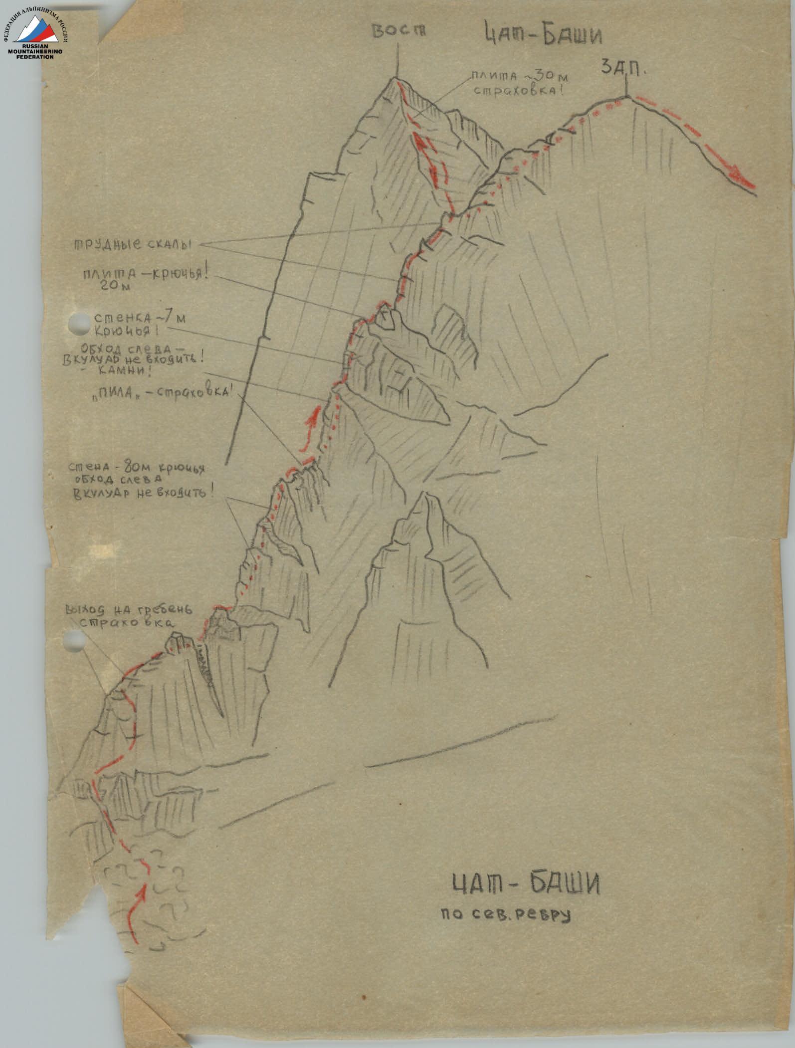
From the bivouac to the left and up along the scree slopes under the Chat pass. Under the pass, bypass the lake to the right and approach the base of the northern edge of peak Chat-Bashi. Ascent to the edge, to the right of the ridge (in rope teams!), and after 60 m — exit to the ridge and along it (sometimes to the left of it) — ascent to the "shoulder" (belays!). From the "shoulder" — ascent to the 80-meter wall, which is bypassed along its left edge (belays! Pitons!).
Beyond the wall — along the ridge to the rock "saw" and through it (belays!) to the ascent of the ridge, which is bypassed to the left. Exit to the ridge before the 7-meter wall. Along the wall straight up (belays!) — exit to the ridge and along it to the slab. Ascent to the slab along its right side — 20 m (belays!) and further along the ridge 150 m — exit to the Western summit. Descent from the West summit into the saddle and further to the left along the scree and through a 30-meter slab — ascent to the Main summit of Chat-Bashi.
From the bivouac to the summit — 7–8 hours.
Descent from the Main summit back into the saddle and further through the West summit along the ridge to the triangulation sign. From it 300 m to the left and down along the large scree, then along the scree ridge — to the bivouac site. Descent from the summit to the bivouac takes 3.5–4 hours.
When ascending on the section "shoulder – 80 m wall" — it is strictly forbidden to bypass to the left along the couloir — rockfall! Dangerous!!
Recommendations for climbers
- Number of participants in the group — no more than 4 people
- Initial bivouac — on a large scree
- Time of departure from the bivouac — no later than 4 am
- Special equipment for a group of 4 people:
a) ropes 2 × 40 m;
b) expendable cordelette — 3 m;
c) rock pitons — 5–6 pcs;
d) rock hammers — 2 pcs;
e) carabiners — 7–8 pcs.

Diagrams and photographs
Fig. №1
- Snowy saddle
- II Internal Corner 15 m. Pitons!
- Shelf
- Rocky ridge made of slabs.
- "Saddle"
- Slab with Internal Corner 10 m. Pitons!
- Wall with overhangs. Pitons! (Photo 1)
- I Internal Corner 40 m. Pitons! Difficult climbing.
- Couloir
- Ridge made of slabs
- Scree shelf
- Control cairn on the shelf
Photo 1
To Fig. №1 — wall with overhangs.
Fig. №2
- Narrow snow-ice chute — do not enter!
- Steep slabs
- Bypassing the chute along the edge of slabs is difficult! Pitons!
- Crevice filled with ice. Do not enter!
- Shelf
- Wall 40 m. 80°, pitons!
- Island
- Ridge 80 m.
- I gendarme
- Saddle
SADDLE IN THE RIDGE (Fig. 2)


Fig. №3
- Slab 65°, pitons!
- Slab 45°, belays!
- Yellow wall
- Shelves
- Slabs 40 m, pitons!
- Slabs 70°, pitons!
- Internal Corner, crevice — difficult climbing! Pitons!
- Narrow shelf
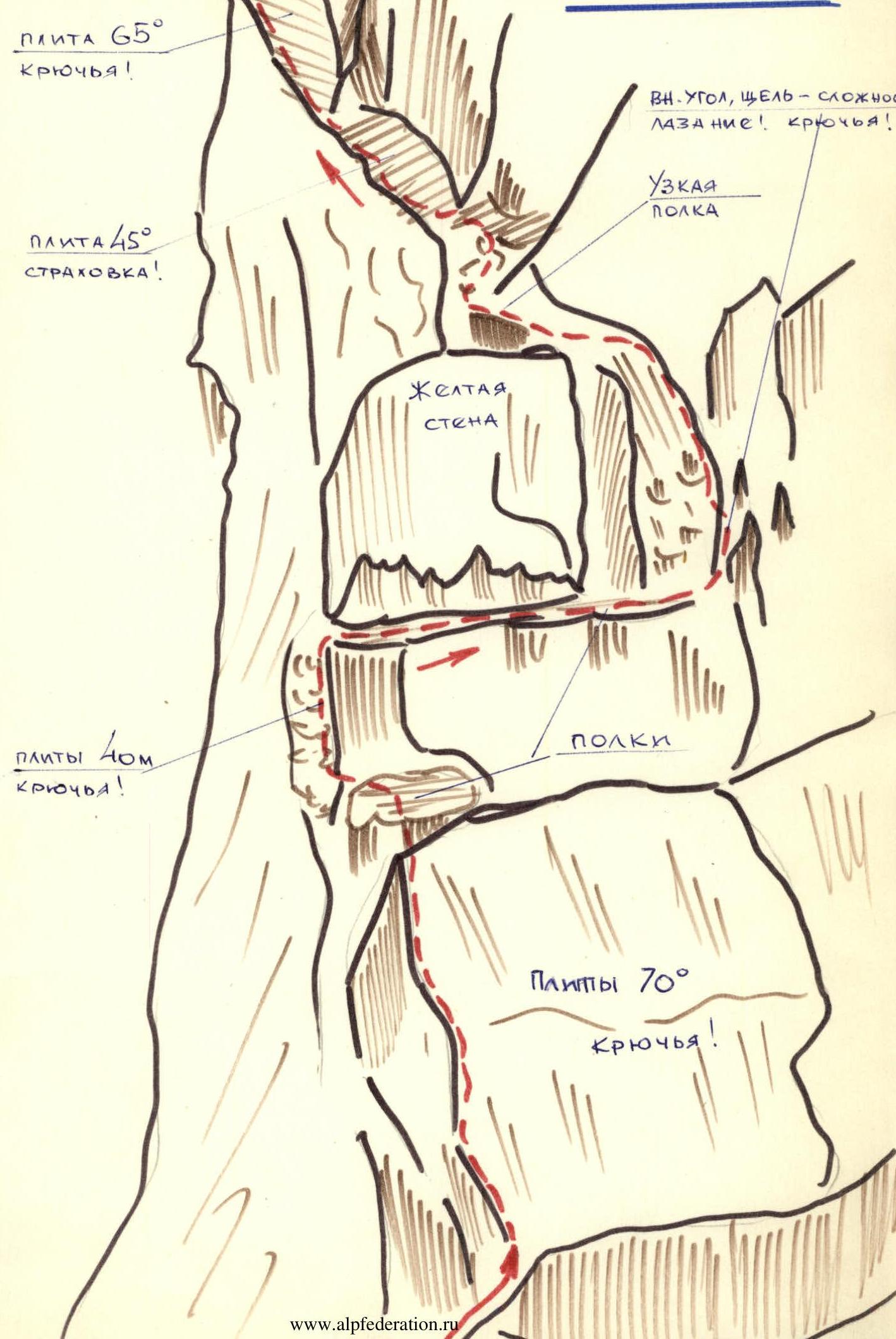
CHAT-BASHI via the northern edge
- Pond rocks!
- Slab — pitons! 20 m
- Wall — 7 m, pitons!
- Do not enter the bypass to the left into the couloir! Rockfall!
- "Saw" — belays!
- Wall — 80 m, pitons, do not enter the bypass to the left into the couloir!
- Exit to the ridge, belays!
- East
- CHAT-BASHI West
- Slab ~30 m, belays!