Ascent Passport
- Caucasus, Uzunkol Valley. Section number in the 1999 classification table - 2.3
- Trapezia Main via SE wall (3743 m).
- Proposed 5B category of difficulty. First ascent.
- Route character - rock.
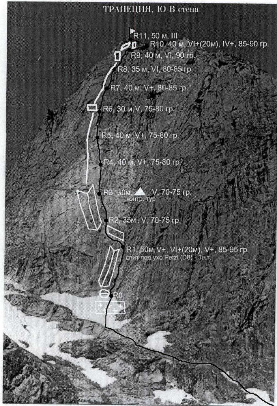
- Height difference: from the assault bivouac to the summit: 580 m wall section: 350 m.
- Length wall section: 430 m. sections of 5th category of difficulty: 245 m, sections of 6th category of difficulty: 115 m.
- Average steepness of the wall section of the route 80°.
- Left on the route: stopper - 1, bolt hanger 1 (ear removed).
Used on the route:
- Stopper закладок stopers — 15
- Large hexes — 5
- Friends — 27
- Pitons — 2
- Removable bolt hangers (PETZL for D8 bolt) — 1
- ITO — 3
- Team's man-hours: to the summit - 16 hours, 1 day.
- Preliminary processing: 1 day, first rope 50 m.
- Participants: Veiko Denis Vadimovich CMS (at the time of ascent not registered) Kolchin Alexander Alexandrovich ICMS
- Coach: Kolchin Alexander Alexandrovich ICMS
- Departure from the camp: 7:00 July 27, 2001. Departure on the route: 4:00 July 29, 2001. Reaching the summit: 19:00 July 29, 2001. Return to the camp: 14:00 July 30, 2001.
- Organization: Gathering of the St. Petersburg Federation, working on the base "Uzunkol".
(1) NOTE: There was no note in the summit tour.
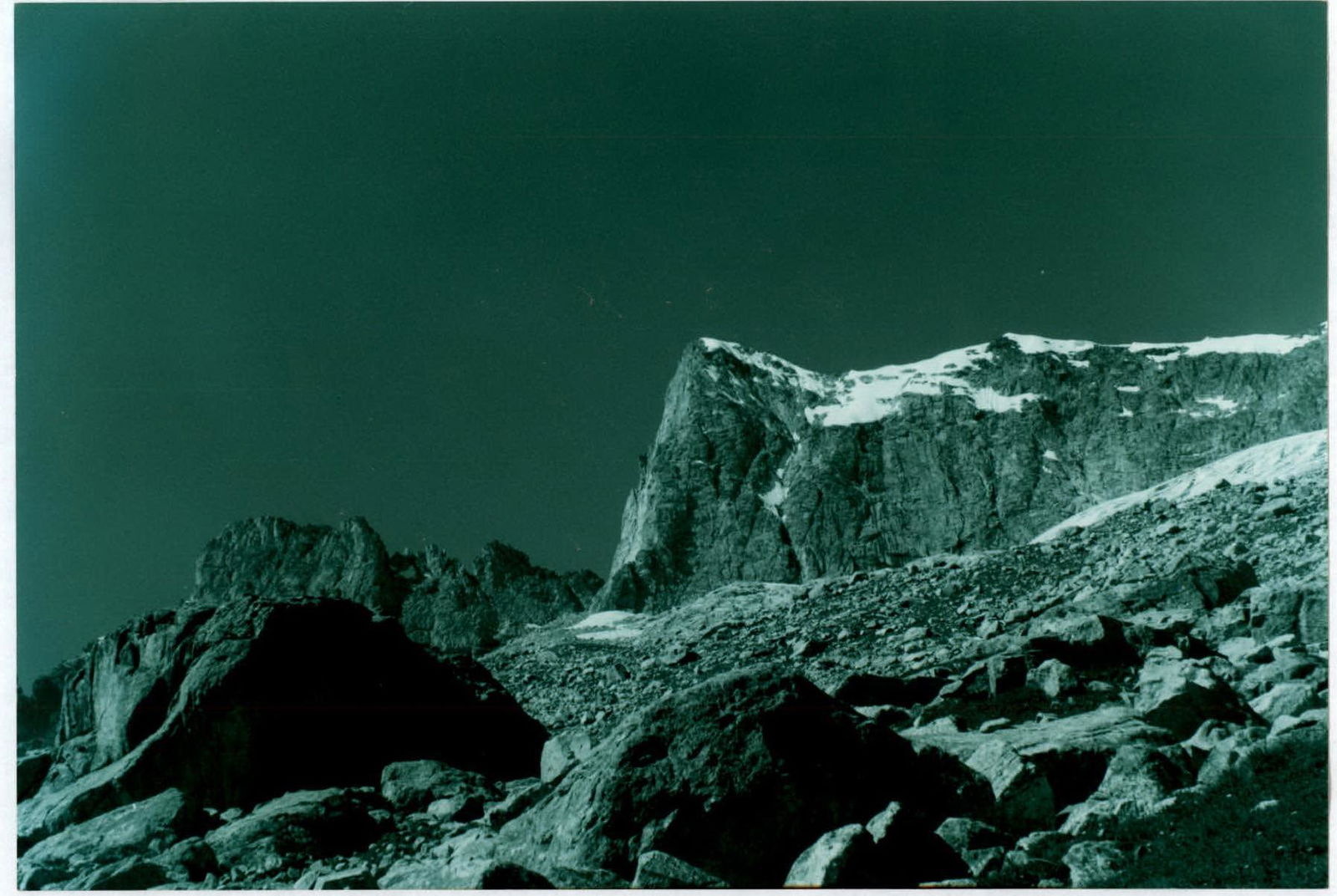
The Trapezia peak is located in the Uzunkol valley in a spur of the GKH, extending from the Dalar peak to the north and dividing the valleys of the Kichkinekol and Mordy rivers.
From the east, from the Kichkinekol valley, Trapezia resembles a tent - a pamirka with a relatively gentle eastern (more precisely ESE) slope and a steep, practically sheer SE wall (the end of the "pamirka"). The array has two summit points at the ends of the summit ridge (the "pamirka" ridge). They are called:
- Main (3743 m)
- NW summit
The first ascents to Trapezia (2A category of difficulty) were made from the west from the Mordy valley (see the book by Delaunay "Peaks and Passes of the Western Caucasus"). Trapezia from this side looks unexpressive, and the route to the Main Trapezia is currently forgotten. In 1935, a route was made from the Kichkinekol valley to the Main peak through the NW summit. This is a good training snow-ice double and the best way down from the summit.
The edge of the SE wall and the ESE slope was climbed in 1963 by K. Rototaev. This ascent started the traverse of the Kichkinekolskaia horseshoe. In the lower part, it is not even an edge, but a pronounced ridge, turning even lower into a "fence" separating small glaciers flowing from under the SE and ESE walls of Trapezia. The exact route of Rototaev is unknown. The route available in the Classifier and described in the book by P.P. Zakharov of 4A category of difficulty was actually made in the same 1963 by A.A. Kolchin on the proposal of P.P. Zakharov (separation of second-raters - N. Borovikova, Gusar, Okhinsky, Tyurikov). This route starts much to the right of the ridge and only in the upper part comes out on the same edge.
In 1968, the SE wall was climbed by a group led by V. Kavunenko. The group had very unpleasant memories of the rockfall danger of the wall. Already on the summit, the group was severely affected by a ball lightning. Most members of the group received severe burns, and O. Korovkin was killed. As a result, the group did not make a description of the route and did not classify it.
This wall, although not long, looks good from the Kichkinekol valley and from the Dolomite overnight stays. If it were not for the incident with Kavunenko's group, it would certainly have been climbed already. From general considerations, it should not be very destroyed and rockfall-prone. Walls of the same aspect in the area (Kirpich, Shokoladny peak) are monolithic. In addition, there is absolutely no "roof" above the wall. The top of the wall is a series of cornices, and the summit tour is located 10 m from the overhanging edge of the wall. Rockfalls, which so frightened Kavunenko's group, apparently were caused by some special weather conditions. During two days of observation directly under the wall, and then during the ascent, we did not notice a single stone that had come off the wall on its own. Rockfalls were constantly noted from the opposite slope, from a small peak located between Trapezia and Shokoladny peak. It is sometimes called the Small Trapezia.
We saw two logical routes on the wall. On the left is an easier one. It starts in the central part along a steep shelf going steeply left - up (30-40 m), and then continues along a system of shelves going further left - up, not so steeply. Unfortunately, the shelves lead to the left edge of the wall in the area of a large jagged edge. To avoid leaving the wall, at some point you need to turn from the shelves to the right - up. We assumed that Kavunenko's group ascended approximately like this.
We chose a different, much more difficult route. In the right part of the wall there is a giant internal corner formed by the left gray wall and the right red one. This is the steepest part of the wall. In the upper part, the corner abuts several rows of cornices. We planned to start the route along the corner (50 m). Then steeply left - up, directly towards the summit, there are several parallel internal corners. Before the summit, they abut a row of cornices. The route was planned along these corners. In fact, the logic of the micro-relief forced us to deviate to the left (about 20 m) from the left corner to a weakly expressed counterfort.
Already after returning from the mountains, we contacted Kavunenko to clarify his route. He doesn't remember the details, but believes that they started somewhere to the left of our start, went along the left part of the wall and at the end went to the ridge to the left of the summit.
Bypass the standard overnight stays under Trapezia "on the lakes" and move further towards the wall of Trapezia. Reach the rocky talus, under which the glacier flows, separating the moraine from the Trapezia array. From here, ascend up the coarse stone scree and rocks about 400-500 m, to the place where the talus ends and a convenient passage of the glacier is visible in the direction of the Trapezia wall. Cross the glacier (ice axe and crampons may be required). Keeping the direction of movement "towards the wall", ascend to the shoulder of Trapezia, running parallel to the glacier. Immediately behind the shoulder - without losing height - exit to a flat snowy cirque directly under the wall of Trapezia. On the shoulder - a convenient and safe place for overnight stays.
From the overnight stays on the shoulder - cross a small cirque under the wall, approach the rantkluft under the right part of the wall, along a system of rocky-snowy shelves of 3rd category of difficulty from right to left ascend to the beginning of the route along the center of the wall. The route begins in a pronounced internal corner formed by the junction of the rusty and gray parts of the wall. The approach to the wall section of the route from the overnight stays on the shoulder takes from 1 to 1.5 hours. Directly under the beginning of the route there is a large flat snowy shelf, where it is convenient to prepare for further movement along the wall (hang iron, put on rock shoes, etc.).
Route - logic, specifics, recommendations.
In general terms, the logic of the route is as follows: the first 50 m along the largest internal corner on the wall (between the gray and rusty parts of the wall), then a traverse to the left towards smaller internal corners on gray rocks, about 40-50 m - movement along a wide gray internal corner, then a transition to the left to a weakly expressed counterfort. Along the counterfort - ascent almost to the end of the wall. On the last rope - a traverse to the right up towards the ridge slightly to the right of the summit. The route goes almost along the direttissima. In total, there are 11 sections on the route (35-50 m each), not counting the approach along the shelves under the wall section of the route. Climbing is mostly difficult (5-6+ category of difficulty), sometimes there are problems with the organization of reliable insurance, there are many live stones and blocks on the route. At the same time, there is no threat of spontaneous rockfalls on the wall. When passing the route for insurance, mainly friends, small stoppers and rock ledges were used, less often large hexes, even less often - pitons. It is recommended to pass the route in one day (there are no good places for overnight stays before ascending to the summit). It is recommended to exit to the route from the overnight stays just before dawn. It is recommended to process the first rope. It is recommended to study in advance the descent path along the glacier to the tents, as a descent in the dark is possible. On the route, before exiting to the summit, there is no water.
Descent
Descent from the summit - along 2B category of difficulty. First along the ridge to the NW (20-40 min) to the end of the Trapezia array, from where to the right down along the snowy slope (400-500 m, 35-45 °, at the end of summer there may be ice), descent to the flat part of the glacier. Along the glacier move in the opposite direction along the NE talus of Trapezia towards the overnight stays. The last section of the descent along the glacier - again steep (70-100 m, 45-50°), there may be ice (ice axe, crampons). Total time on the route "from tents to tents" - 14-18 hours.
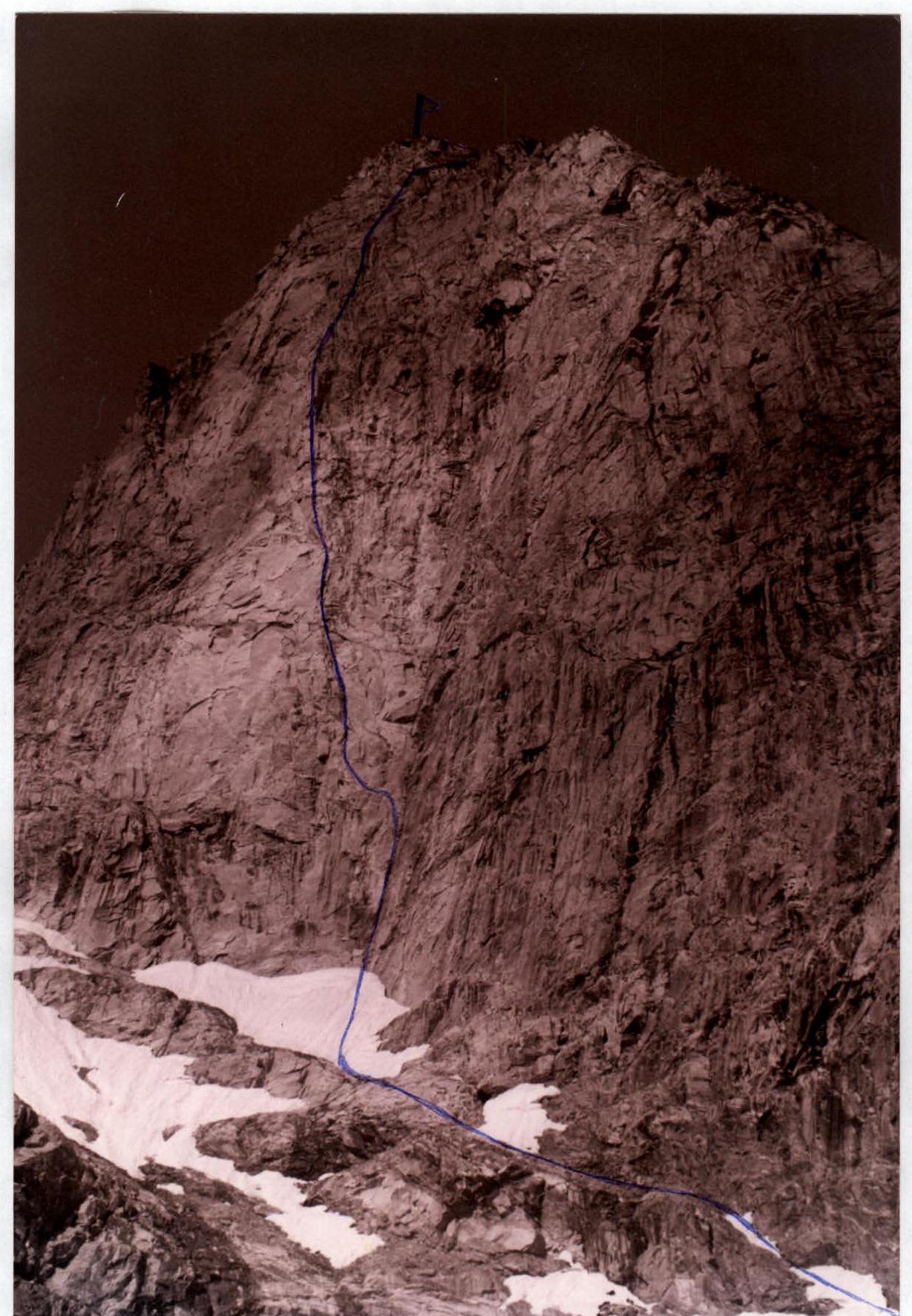
Trapezia Main. SE wall. View from overnight stays in the cirque under the wall.
Trapezia Main. Profile of the SE wall. View from Kichkinekolskaia overnight stays. Sections of the route 1-4 are closed by the lower part of the eastern ridge