Ascent Passport
- Climbing type — rock climbing
- Climbing area — Uzunkol tourist center, Western Caucasus
- Ascent route — Kirpich peak 3744 m, right part of the Western wall
- Proposed category of difficulty — 3B
- Route characteristics — height difference — 850 m
- Pitons hammered for belaying:
- rock pitons — 32 pcs.
- bolt pitons — 0
- ice pitons — 0
- Number of climbing hours — 10 hours
- Number of nights on the route — none
- Group composition:
- Imaev Rif Giniyatovich — 1st sports category — leader
- Maslennikov Vladislav Yakovlevich — 1st sports category — participant
- Aktuganov Askar Iskanderovich — 1st sports category — participant
- Korotkova Natalia Vasilievna — 1st sports category — participant
- Senotov Viktor Alekseevich — 1st sports category — participant
- Team coach: Master of Sports Zakharov P.P.
- Date of departure to the route and return to Uzunkol tourist center — July 25, 1978
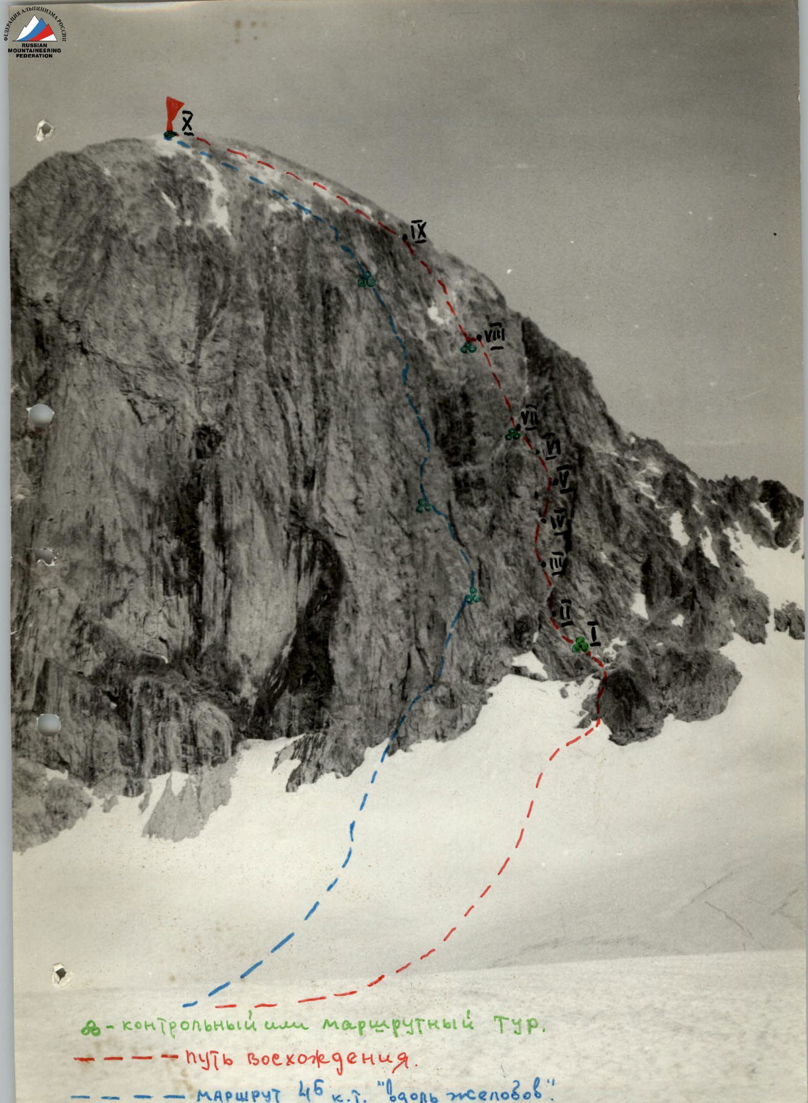
Kirpich Peak
Ascent via the right part of the Western wall (as seen from below) 3B category of difficulty approximately.
From the Uzunkol alpine camp, follow the trail to the Myrdy bivouac. From the Myrdy bivouac, crossing the Myrdy glacier, approach the Western wall of Kirpich. The starting point of the route is marked by two rocky peninsulas of oval shape. Bypass the left peninsula on the left along a steep snowy slope. Exit to a wide ledge via broken rocks (R0–R1). First control cairn. From the cairn, move left along the ledge for 20 m, then along the internal corner for 40 m, 55–60°, with piton belay. Exit to a wide couloir (R1–R2). Move 20 m along the right side of the couloir, then cross the couloir for 20 m, and exit to its left side. Then move up along smoothed rocks to the right part of the counterfort for 40 m, 55–60°, with piton belay (R2–R3). Along the right side of the counterfort, move up along smoothed slabs for 140 m, exit to a wide ledge under a black internal corner, 55–60°, with piton belay (R3–R4). Move up and to the right from the black internal corner for 40 m, 60°, with piton belay (R4–R5). Then move 80 m along rocks resembling "ram's foreheads" for 45–50°, with piton belay (R5–R6), exit to a ledge in front of a wall 5–6 m, 75–80°, with a small internal corner. Difficult climbing, exit to the ridge of the counterfort and then along rocks of moderate difficulty for 80 m, 50–55°, exit to a wide ledge (R6–R7). Route cairn. Traverse left with a gain in height along a couloir that leads to the ridge, 60 m, 45–50°, exit to a wide terrace under a gray wall (R7–R8). Along the terrace, move right to left for 80 m towards rocky grooves until the second control cairn. Then move up and to the right — exit to gray smoothed rocks. To the left of the direction of travel, rocky grooves are clearly visible. Move straight up along the rocks for 200 m, 45–50° (R8–R9), with piton belay, exit to the pre-summit dome. Along broken rocks, moving left, exit to the summit (R9–R10) 250 m. Descent from the summit follows the 1B category of difficulty route.
Table of technical characteristics of the 3B category route to Kirpich peak via the right part of the Western wall
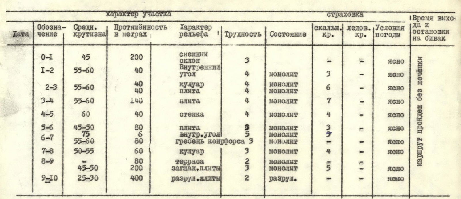
| Designation | Average steepness | Length in meters | Relief character | Difficulty | Condition | Belay (rock pitons) | Belay (ice pitons) | Weather conditions | Time of departure and bivouac stop |
|---|---|---|---|---|---|---|---|---|---|
| R0–R1 | 45° | 200 m | Snow slope | 3 | — | — | — | Clear | — |
| R1–R2 | 55–60° | 40 m | Internal corner | 4 | Monolith | 3 | — | Clear | — |
| R2–R3 | 55–60° | 40 m | Couloir | 4 | Monolith | 6 | — | Clear | — |
| 40 m | Slab | 4 | Monolith | — | — | Clear | — | ||
| R3–R4 | 55–60° | 140 m | Slab | 4 | Monolith | 7 | — | Clear | — |
| R4–R5 | 60° | 40 m | Wall | 4 | Monolith | 4 | — | Clear | — |
| R5–R6 | 45–50° | 80 m | Slab | 9 | Monolith | 3 | — | Clear | — |
| 75° | 6 m | Internal corner | 5 | Monolith | 9 | — | Clear | — | |
| R6–R7 | 55–60° | 80 m | Counterfort ridge | 3 | Monolith | — | — | Clear | — |
| R7–R8 | 50–55° | 60 m | Couloir | 3 | Monolith | 4 | — | Clear | — |
| R8–R9 | — | 80 m | Terrace | 2 | Monolith | 5 | — | Clear | Route completed without overnight stay |
| 45–50° | 200 m | Smoothed slabs | 3 | Monolith | — | — | Clear | — | |
| R9–R10 | 25–30° | 400 m | Broken slabs | 2 | Broken | — | — | Clear | — |
Kirpich Peak 3800 m
Ascent via the Western wall from the Myrdy glacier, category 5A difficulty, "along the grooves".
From the Uzunkol alpine camp, follow the right bank of the Myrdy river to the Myrdy bivouac. From here, along the gray moraine under the slopes of Kara-Baschi peak, exit to the plateau of the Myrdy glacier. The journey from the camp to the plateau takes 3.5–4 hours.
Cross the plateau and approach the wall of Kirpich — to the right of the route, along a rhomboid shape. A snowy slope up to 40°, approximately 120 m, leads to the wall, narrowing into a kind of gate between two rocky foundations of counterforts. The left one is the lower part of a large rocky wall with black streaks; the right one is the right part of a huge groove, where the ascent begins. The left part of the "gate" resembles a huge bottle. Under the right rocks at the start of the route, there is a large ranilift, which narrows to almost nothing at the narrowest part of the "gate".
From the level of the ranilift, move up along a steep, narrow snowy slope, 40°, 50 m, to the beginning of the rocks. Along the right side of the internal corner (gray rocks), move up 30 m to a ledge on a sharp rib, and from it 3 m straight up, then 25–27 m traverse to the right — initially along a steep slab (65°), with pitons, and then with a slight gain in height to a wide ledge. On the right edge of the ledge, there is a route cairn. From the cairn, move straight up 20 m, then 10 m along a ridge to a ledge, 70–75°, with pitons! Immediately from the ledge, cross a groove (which turns into a huge internal corner at the top) and climb up along its right gray wall to a hanging separate gray rock. Pass to the left of it and exit to a ledge on the ridge of a not clearly defined counterfort — 30 m, difficult climbing — 75°, with pitons!
From the ledge, move straight up, bypassing a rock plug in a crack with an exit onto it — 6 m. Difficult climbing! And straight along the ridge for 30 m, 70°, with pitons! — through separate live blocks along the right part of the gray wall of the huge internal corner to the beginning of a crack in this wall. Move up along the crack for 20 m, with pitons! to its upper part. Here, there is a wide green ledge.
From the ledge, move straight up along the right fissure with greenery to the upper part of the gray slabs, with pitons! And after 40 m, traverse left for 30 m under a black wall, and from here, left along an osypnoy couloir to a green ledge, with pitons! On the left part of the ledge, near the ridge, there is a route cairn. From the ledge, move right — bypassing a block of cornices along steep, cracked rocks for 50 m, with pitons! And then up and left for 20 m along a gray crack, with pitons! to the beginning of a not clearly defined balcony — 15 m — above the block of cornices. Along the ledge, move left to its end, and straight up along a crack turning into an internal corner for 60 m, with pitons! When water flows, it is possible to climb using ladders. Exit from the corner to white rocks onto a large ledge. From the ledge, move left for 5 m and 10 m up along a steep wall, then traverse right for 10 m, with pitons! to an earthen ledge. From here, move up along the wall for 15 m, with pitons! And after 100 meters of rocks resembling "steep ram's foreheads" — exit to the gate. Along black streaks of an old stream and stones of a stepped structure. Move up along them for 30 m, with pitons! to a short ledge on the right, and then straight up for 30 m to an inclined ledge. Climbing is tense — small holds. From here, move right for 5–7 m to gray stepped rocks and along them for 15 m to the end of the wall, leaving oblique ledges to the right — bypassing a gendarme-"pillar" for 10 m. And again, moving slightly left, exit after 30 m, with pitons! to the upper edge of the wall. The landmark is a huge three-headed gendarme standing to the left, marking the end of the wall. From here, move 300–320 m along simple rocks (separate blocks, slabs, etc.) to the summit osypnoy and snowy dome, and along it for 400 m — exit to the cairn on the summit.
Descent from the summit follows the 1B category of difficulty route.
From the base of the wall under the ranilift to the summit with one overnight stay — or immediately upon exiting the wall, or on the summit. In dry weather, it is possible to climb the wall and descend in one day — approximately 13–15 climbing hours.
Recommendations for climbers
- Number of participants in the group — 4–8 people.
- Initial bivouac — "Myrdy bivouac".
- Time of departure from the bivouac — 4:00 AM.
- Special equipment for a group of 4 people:
- main rope 2×60 — climb on a double rope.
- expendable cordelette 4 × 5 m.
- rock hammers — 3 pcs.
- rock pitons 20 pcs. — predominantly horizontal.
- karabiners — 20 pcs.
- protective helmets — 4 pcs. — mandatory!
- 2-rung ladders — 2–3 pcs.
- Possible bivouac locations: sitting — practically along the entire route, a tent can be set up upon exiting the wall and further everywhere.
The first ascent of the route was made by a group from the Uzunkol tourist center in 1968:
- Sedov G.K. — leader.
- Zakharov P.P. — participant.
- Belyaev Yu.S. — participant.
- Schyotkova G.V. — participant.