Ascent Passport
- Ascent class: rock
- Ascent area: Uzunkol tourist center, Western Caucasus
- Ascent route: Maly Dalar peak, 3500 m — via the southern counterfort.
- Proposed difficulty category: 3B category of difficulty.
- Route characteristics: height difference — 600 m, average steepness — 50–55°.
- Pitons driven: for belaying: rock 37 pcs., ice 0, bolted 0. for creating RTO (Relay and Belay Point): 1 pc., 0, 0.
- Number of travel hours: 7 hours.
- Number of nights on the route: there are no nights on the route.
- Surname, name, patronymic of the leader and participants, their sports qualification:
- Khafizov Alexander Faridovich, 1st sports category, leader
- Poroykov Vladimir Ivanovich, 1st sports category, participant
- Khairullin Rais Shamsimukhametovich, 1st sports category, participant
- Masunov Vladimir Semenovich, 1st sports category, participant.
- Team coach: Aktaganov A.I.
- Date of departure on the route and return to the tourist center: July 13, 1977, departure on the route and return to the tourist center.
Maly Dalar: Ascent via the Southern Counterfort 3B Category of Difficulty.
From the Uzunkol alpine camp along the trail to the Myrdy gorge. Along the right side of the gorge (trail) to its end, left across the bridge over the stream flowing from the Myrdy glacier, and along the trail to the ridge of the large gray moraine. Along the ridge to the end. The ram brows at the end of the moraine are bypassed on the left along the large scree with an ascent to the lateral moraine of the Severny Dalar glacier (a site for overnight stays). From the Uzunkol tourist center — 4–5 hours, from here across the glacier plateau (in ropes) to the Dalar pass. The bergschrund is overcome along a snow bridge (in the second half of summer, the bergschrund passes to the left with an exit to a reddish rocky island).
From the pass, left along the snow to the southern counterfort of the Maly Dalar peak. The beginning of the route is in the center of the counterfort — 20 m, then to the right along a narrow (10–15 cm) ledge under an overhanging wall — 8–10 m and from here straight up to the triangular wall. Climbing is very difficult, few holds, piton belay (section R0–R1).
Further:
- bypassing the triangular wall on the right along the inner eight-meter corner-ladder, pitons;
- exit to the left onto the ridge of the counterfort;
- along the ridge (steep slabs, pitons) after 40 m — a good ledge, where you can gather everyone, here is a control cairn (section R1–R2).
To the cairn — 2.5–3 hours, steepness of the section 75–80°, belay is exclusively piton.
From the cairn, 50 m along the ridge 45–50° (section R2–R3), and further along the gray inclined slabs (section R3–R4) — 140 m of climbing of medium difficulty (piton belay) with an exit to a sharp ridge (section R4–R5), leading to a gendarme with a large stone lying on its top; to the left — steep inclined slabs, and to the right — sheer walls.
Bypassing the gendarme on the left along steep rocky blocks (section R5–R6), leading after 100 m to a sharp ridge (section R6–R7) — a psychologically challenging ridge, with sheer drops on both sides.
And further along the ridge, exit to a small snow couloir separating the false and main peaks (section R7–R8).
Crossing the couloir to its right side along large stones, in its middle part (section R8–R9), and along the right side — ascent to the peak (section R9–R10).
From the control cairn to the peak — 4–4.5 hours.
Descent from the peak along the southwestern ridge under the gendarme "Stolb" and along the ledge down, pressed to the walls of the ridge, and further along the system of ledges going down to the snowfield, and further to the Dalar pass.
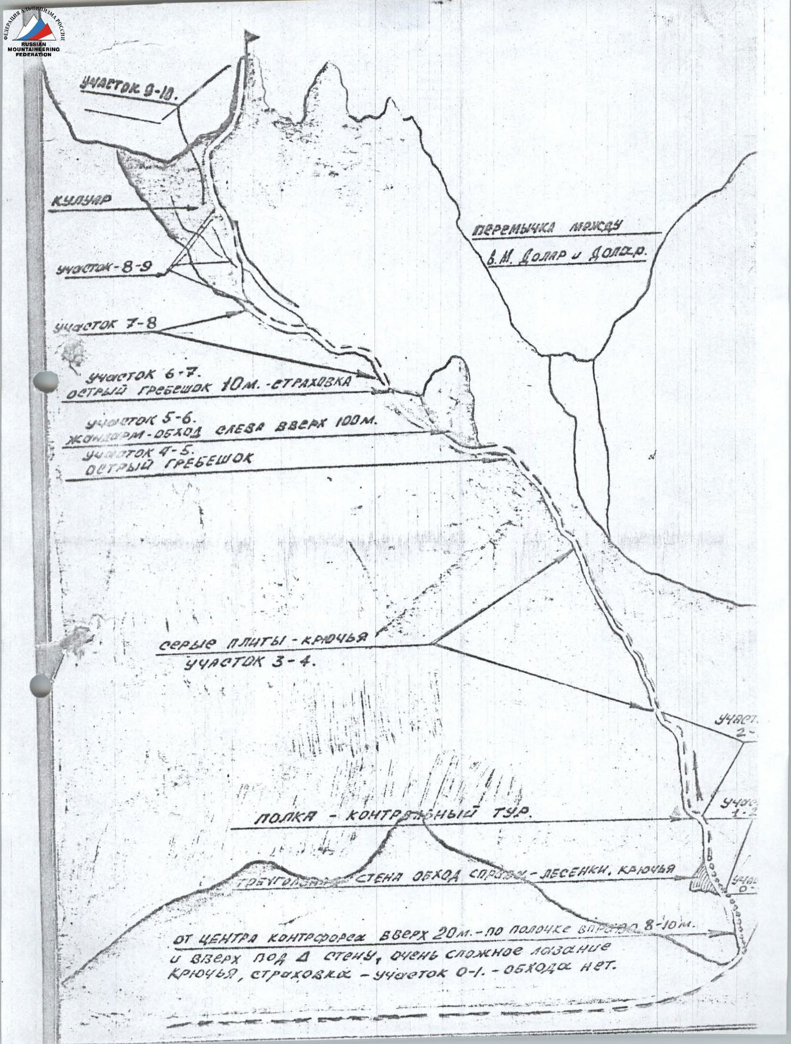
Table of Technical Characteristics of the 3B Category of Difficulty Route to Maly Dalar Peak via the Southern Counterfort
| Date | Designation of Section | Average Steepness | Length in Meters | Character of Relief | Difficulty (+2) | Condition (+3) | Weather Conditions | Belay (+4) Rock | Belay (+4) Ice | Belay (+4) Bolted | RTO | Time of Departure and Stop for Bivouac, Overnight Conditions |
|---|---|---|---|---|---|---|---|---|---|---|---|---|
| 13.07.77 | R0–R1 | 75–80° | 40 m | edge | 5 | monolith | clear | 10 pcs. | - | - | 1 pc. | |
| R1–R2 | 80–85° | 40 m | inner corner | 5 | monolith | 9 pcs. | - | - | ||||
| R2–R3 | 45–50° | 50 m | edge | 4 | 8 pcs. | - | - | |||||
| R3–R4 | 40–45° | 140 m | slabs | 3 | 10 pcs. | - | - | |||||
| R4–R5 | 25–30° | 80 m | slabs | 2 | - | - | natural features | |||||
| R5–R6 | 60–65° | 100 m | couloir | 2 | destroyed | - | - | |||||
| R6–R7 | 20–25° | 40 m | ridge | 1 | - | - | ||||||
| R7–R8 | 30–35° | 250 m | 1 | - | - | |||||||
| R8–R9 | 25–30° | 40 m | couloir | 1 | - | - | ||||||
| R9–R10 | 40–45° | 80 m | 2 | - | - | The route was completed without overnight stays. |
