
Ascent Passport
- Ascent class — rock
- Ascent area — Western Caucasus (from Marukh pass to Makhar pass)
- Peak, its height, ascent route — p. Yubileynyy (3567 m) via the Western wall
- Estimated difficulty category — 5A
- Route characteristics: elevation gain — 475 m length of sections with 5–6 difficulty category — 245 m average steepness — 67°
- Pitons hammered:
| For belay | For creating ITO | |
|---|---|---|
| Rock | 35 | 3 |
| Ice | — | — |
| Bolt | — | — |
- Number of climbing hours — 11 h
- Number of overnight stays and their characteristics — 1, lying down
- Full names of participants and their sports qualification — Andryushchenko Anatoliy Viktor., 1st sports category — Ponimatko Oleg Ivanovich, 1st sports category
- Team coach — Bolizhevskiy Yuriy Konstant., USSR Master of Sports
- Date of team's departure and return — August 13–14, 1978

 Peak Yubileynyy (3567 m). General view
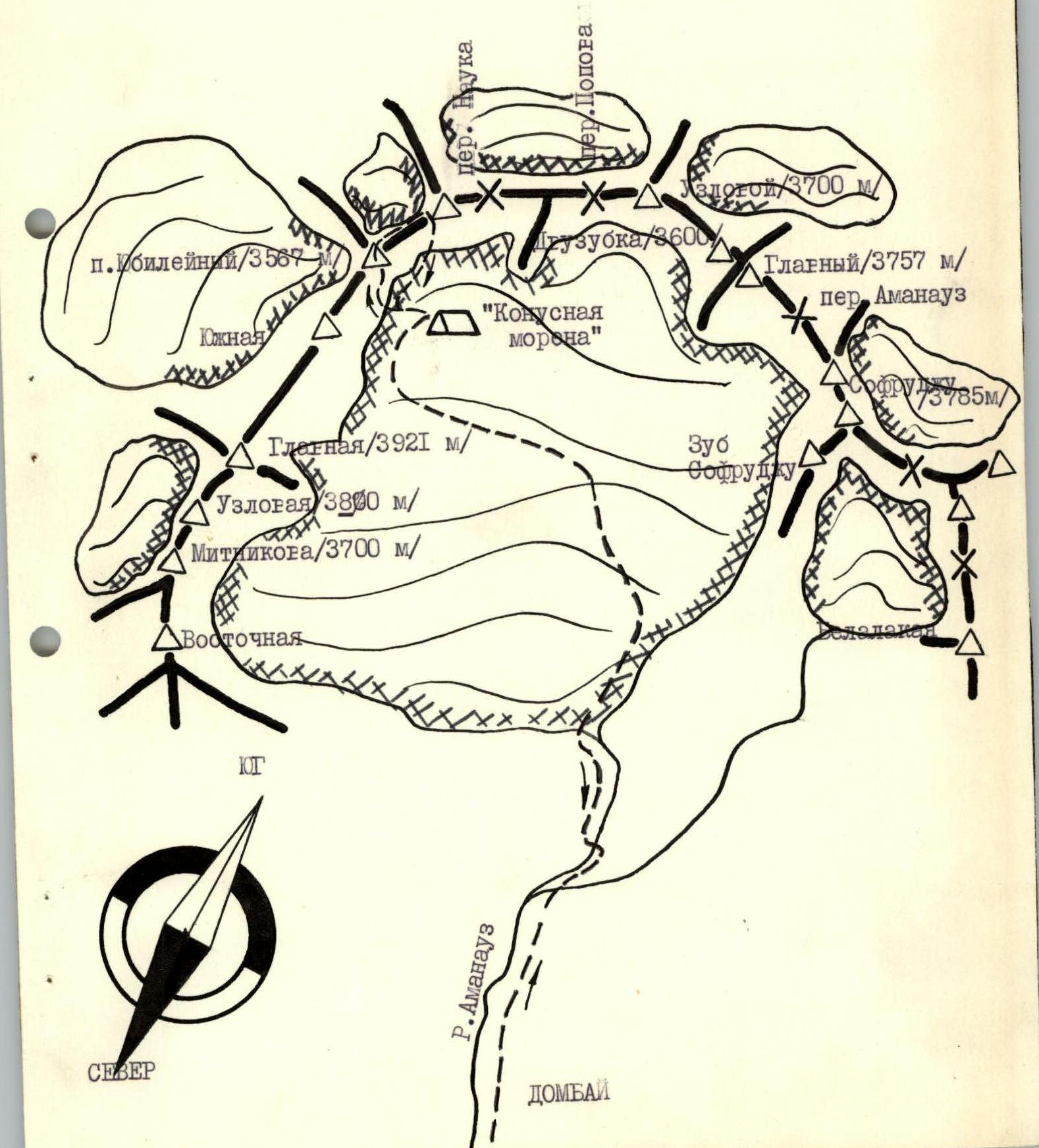
Brief geographical description of the ascent area
Peak Yubileynyy is located in the Western Caucasus and is situated in the ridge connecting the Jugu-turlyu-chat massif with the Amanauz massif. Our attention was drawn to the Western wall of p. Yubileynyy. Practically vertical and monolithic, it starts directly from the glacier and continues almost to the very top. The ascent via the Western wall (or along its left edge) is logical and safe. Deviating left into the wide couloir between v. Jugu-turlyu-chat South and p. Yubileynyy is hazardous due to the presence of very steep, destroyed rocks. We have repeatedly observed rockfalls in this couloir. Rocks shoot across most of the glacier beneath the couloir. In 1953, in honor of the 30th anniversary of Soviet mountaineering, the first ascent of p. Yubileynyy was made via the South wall (from Nauka pass), and in the same year, the peak was traversed during a relay traverse of the Main Caucasian Range. After that, no ascents of peak Yubileynyy were made.
Brief description of climbing conditions in the area
The Amanauz valley is enclosed by the walls of the Amanauz and Jugu-turlyu-chat massifs. A characteristic feature of these walls is their great steepness and monolithicity. The Western wall of p. Yubileynyy (3567 m) faces the Amanauz glacier. The rocks are monolithic, smooth, with few footholds. Overnight stays on the route are possible on the wall, at the summit, and under the bifurcated gendarme during the descent. Meteorologically, the Amanauz valley lives up to its translation from the Circassian language, "Rotten corner." Warm air masses from the Chkhalta valley, rising, collide with the cold front over the Amanauz glacier. The weather is unstable, and the peaks are often shrouded in clouds.
Reconnaissance exits
The approach to the route directly from Dombay plain takes 5–6 hours. It is convenient to set up a base camp and observers on the so-called "conical" moraine on the Amanauz glacier. From here, the entire route, except for the lower part of the wall, and the approaches to it are clearly visible.
The route to p. Yubileynyy via the Western wall has been observed multiple times from vv. Amanauz Main and Sofruju. On August 6 of the same year, a group of climbers in the same composition, after 2 days of observation, attempted to ascend p. Yubileynyy but was forced to return from the route due to a sharp deterioration in the weather.
Map of the ascent area
Brief description of the route
From Dombay plain, cross the bridge over the Alibek river and follow the trail to the stream flowing from the Big Belalakay couloir. Cross the stream and follow the left (orographic) bank of the Amanauz river through the "ram's foreheads" onto the Amanauz glacier and along the left (in the direction of travel) part of the glacier to a bivouac on the "conical" moraine. From Dombay plain — 2.5–3 hours. The start of the route — up the center of the wall, 10–12 m to the right of the internal corner-fracture, directly up the difficult, smooth rocks for 30 m to a ledge, then along the ledge left for 6–7 m to an internal corner, and up it for 20 m to a wider spot, and then left and up through tile-like rocks with "feathers" — exit under the main wall. Here is a platform for an overnight stay, 1st control cairn. Then traverse 40 m left along a narrow, partially interrupted ledge to its end. From here, up and to the right for 40 m through difficult monolithic rocks and then up and to the left for 20 m — exit onto the "edge" of the wall through very difficult rocks with a 3-meter overhanging wall. The rocks are smooth, with few footholds and cracks for pitons. Up the "edge" of the wall for 60 m through rocks of above-average difficulty — under an overhang. The overhang is climbed "head-on" towards an internal corner using ITO, and then through very difficult rocks of the internal corner and steep slabs — exit onto a small shoulder. From the shoulder, 80 m through difficult rocks of blocky character — exit onto the gendarme "Kub." Here is the 2nd control cairn. The ascent from the glacier to the second cairn takes 7–8 hours. Further, up and to the left through destroyed rocks of medium difficulty to a gap in the pre-summit ridge. Exit onto the ridge through an internal corner with an overhanging "roof." Along the ridge for 80–100 m — to the summit. From the 2nd control cairn to the summit — 1–1.5 hours. A bivouac is possible at the summit.
Descent from the summit towards Nauka pass along the destroyed ridge to slab-like rocks. Down these with alternating belay for 80–100 m — descent onto a "balcony." From the "balcony" — rappel descent for 80 m (with a re-clip on the wall) under the bifurcated gendarme. The gendarme is passed between the teeth with a descent into the gap under the large gendarme. Here is a platform for an overnight stay. From here, through heavily destroyed rocks — right for 40 m to a wide talus ledge. From the ledge — a diagonal 40 m rappel descent left under a characteristic "finger." From under the "finger," 30 m — rappel descent onto the glacier. The descent from the summit to the glacier takes 3.5–4 hours. From the glacier to the overnight stays on the "conical" moraine — 40–50 minutes.
Conclusion on the route
The route to p. Yubileynyy (3567 m) via the Western wall is logical, safe, and beautiful. The route is purely rock, with great steepness. The route is characterized by walls with few relief features. The most challenging sections of the route are the exit to the left "edge" of the wall and the 3rd rope of the edge itself. Throughout the route, destroyed rocks are encountered only when exiting onto the pre-summit ridge. The set of pitons should be universal: from petal-shaped to channel-shaped. Insurance loops and stoppers can be used on the route. For the 3rd rope of the edge, ladders are required. Bivouacs are possible on the wall, at the summit, and during the descent under the bifurcated gendarme. All indicated bivouacs are lying down. It can be recommended to following groups of climbers to spend the night on a convenient platform on the wall on the day of the approach. The optimal number of participants in a group is 4. Comparing the route with previously climbed wall routes of 4th and 5th difficulty categories, the group believes that the route to p. Yubileynyy via the Western wall significantly surpasses in complexity such well-known routes as Belalakaya via the Western edge 4B category, Dombay-Ulgen West from Dombay pass 5A category, Jailyk via the North wall 5A category; it is not inferior to routes like Jailyk via the Southeast wall 5A category, Tyutyu-Bashi 1st West via the South wall of the South buttress 5A category, Dombay-Ulgen Main via the Northwest wall 5B category, and deserves (due to its relatively short length) a 5A category.
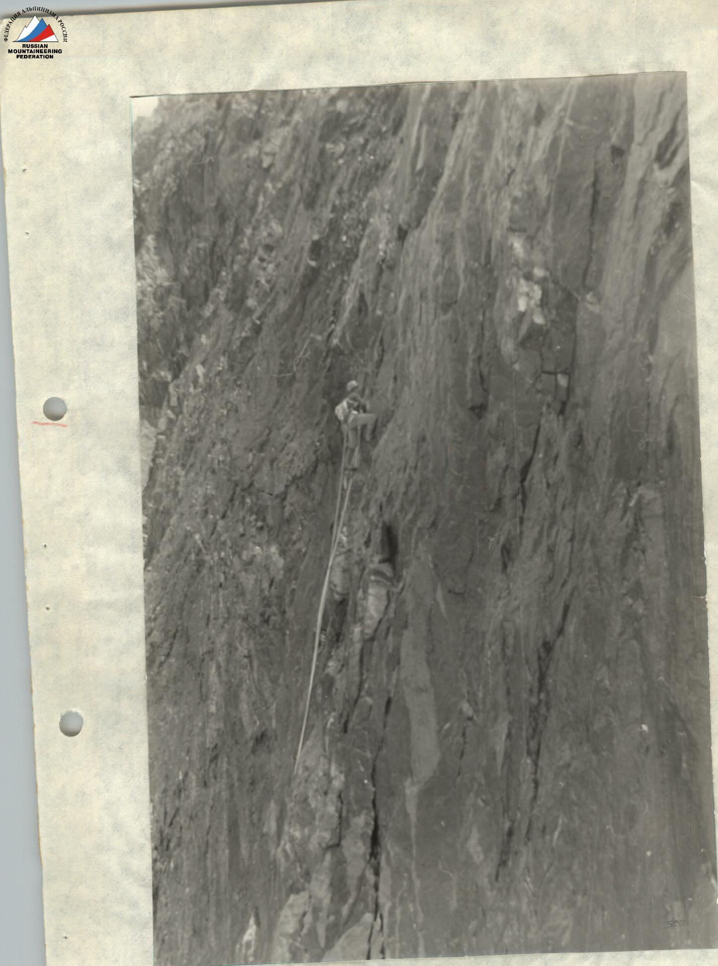 Section R0–R1. Passage of the 1st rope of the route.
Report
on the third passage of the route to the summit of p. Yubileynyy 4B category by the team of instructors AUS/B "Alibek" led by Sukavitsin G.Ya.
Western Caucasus, 1985.
Map of the ascent area
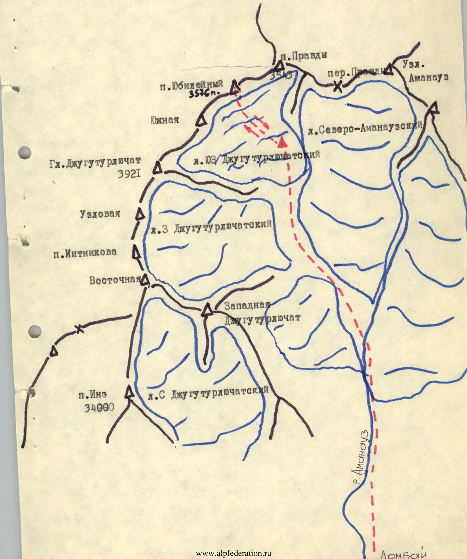
Route of ascent to p. Yubileynyy
via the Western wall 4B category

Description
of the ascent route to peak Yubileynyy via the Western wall 4B category
From Dombay plain, follow the right side (in the direction of travel) of the Amanauz river along the trail to the "ram's foreheads" and through them — exit onto the glacier and further onto the "conical" moraine of the Amanauz glacier. A place for a bivouac. From the "conical" moraine — through the "ram's foreheads" and then along the second step of the Amanauz glacier in the direction of the Western wall of p. Yubileynyy. A bivouac is possible under the bergschrund. From Dombay plain — 5–7 hours. The start of the route — up the center of the wall, 10–12 m to the right of the internal corner-fracture. Up the wall directly through difficult, smooth rocks to a ledge, along it left for 6 m to an internal corner, and up it for 20 m to a wider spot, and then left and up through tile-like rocks with "feathers" — exit under the main wall. Control cairn #1. A convenient bivouac for two people. From the start of the wall — 2–3 hours. Further, traverse 40 m left along a narrow, partially interrupted ledge to its end. From here, up and to the right for 40 m through difficult monolithic rocks and 20 m up and to the left — exit onto the "edge" of the wall through a 3-meter overhanging wall. The rocks are smooth, with practically no cracks. Up the "edge" of the wall through rocks of above-average difficulty for 60 m — under an overhang, which is climbed "head-on" towards an internal corner to the right (in the direction of travel) using ITO, then through very difficult rocks of the internal corner and steep slabs — exit up and to the right onto a small shoulder. From it, through difficult rocks of blocky structure for 80 m — exit onto the gendarme "Kub." Control cairn #2. From control cairn #1 — 8–9 hours. From the gendarme "Kub," steeply up and to the left through destroyed rocks of medium difficulty to a gap in the pre-summit ridge. Exit onto the ridge in the gap through an internal corner with an overhanging "plug." Along the ridge for 100 m to the summit. A convenient bivouac is possible at the summit. From control cairn #2 — 2–3 hours. Descent from the summit towards Nauka pass along a steep, destroyed ridge to slab-like rocks. Down these with alternating belay for 100 m — descent onto a "balcony." From the "balcony" — rappel descent for 80 m (with a re-clip in mid-air) under the bifurcated gendarme. The gendarme is passed between the teeth with a descent into the gap under the large gendarme. A convenient place for a bivouac. From here, through heavily destroyed rocks to the right for 40 m to a wide talus ledge, from the ledge — a diagonal sporty descent left under a characteristic "finger." From under the "finger" — rappel descent for 30 m onto the glacier. The descent from the summit to the glacier takes 4–5 hours.
Recommendations for climbers:
- Initial bivouac — under the wall at the 1st control cairn, group size — 4 people, main rope — 4 × 40 m, rock pitons, stoppers — 25–30 pieces, ladders, expendable cordelette — 20 m.
- The couloir between v. Jugu-turlyu-chat South and p. Yubileynyy is rockfall-prone! When ascending, follow the description, do not deviate left along the ledges.
Comments
Sign in to leave a comment