
пр. № 431 от 1/3-77, п.4. ЗА, пп.
Report on the Ascent of Main Kara-Kaya Peak via the First Ascent Route on the Eastern Ridge, approximately Category 3B difficulty, August 8, 1975
Main Kara-Kaya Peak is located in the Karakai spur of the Main Caucasian Range. The peak can be accessed via four ridges:
- Eastern
- South-Eastern
- Northern
- South-Western
Favorable weather conditions, convenient access routes, and an abundance of classified and unclassified routes of various difficulty levels make this peak highly interesting for mountaineers. The following routes have been classified on Main Kara-Kaya Peak:
- via the South-Eastern ridge — Category 2B
- via the Northern ridge — Category 4A
- traverse of the Kara-Kaya massif from the West Kara-Kai pass — Category 5A
- via the North-West wall — Category 5B
The nearest mountaineering base area is "Domбай". In the upper reaches of the Aksaut gorge, in the Rudnichny settlement, near the Kara-Kaya massif, are located:
- KSP of the Aksaut region
- Aksaut branch of the "Domбай" tourist center
From the Rudnichny settlement, a logical path to the summit of Main Kara-Kaya via the Eastern ridge, approximately Category 3-4 difficulty, is visible.
The first ascent of Main Kara-Kaya via the Eastern ridge, followed by a descent via the South-Eastern ridge, was made by a team from the Aksaut branch of the "Domбай" tourist center (Kiev regional council of the "Avangard" sports society), comprising:
- Laskavy D.P. — 2nd sports category, team leader
- Bereznoi S.V. — participant
- Ivanov N.R. — participant
- Forostyan V.Yu. — participant
- Tsvetkova G.M. — participant
The team departed from Rudnichnoe settlement on August 7, 1975, at 13:00, following a trail leading to the North Kara-Kai pass, and set up a bivouac under the South-Eastern Kara-Kai left glacier at 16:00. The ascent was made on August 8, 1975, in full team composition, under good weather conditions. The team departed from the bivouac at 4:00. The following equipment was used during the ascent:
- Personal gear
- Main rope — 2 × 40 m
- Rock pitons — 12 pieces
- Carabiner clippers — 8 pieces
- Rock hammers — 2 pieces
- Tent, stove (in case of changing weather conditions)
- "Vitalka" radio set — 1 piece
The description of the approach to the route, the ascent route, necessary diagrams, tables, and illustrations are provided below.
On August 16-18, 1975, the route was repeated in more challenging weather conditions by a team from the "Aksaut" tourist center (branch of the "Domбай" tourist center), comprising: Braer V. — team leader, Voloshin A., Voloshina R., Shoma V., and was assessed as a Category 4A route.
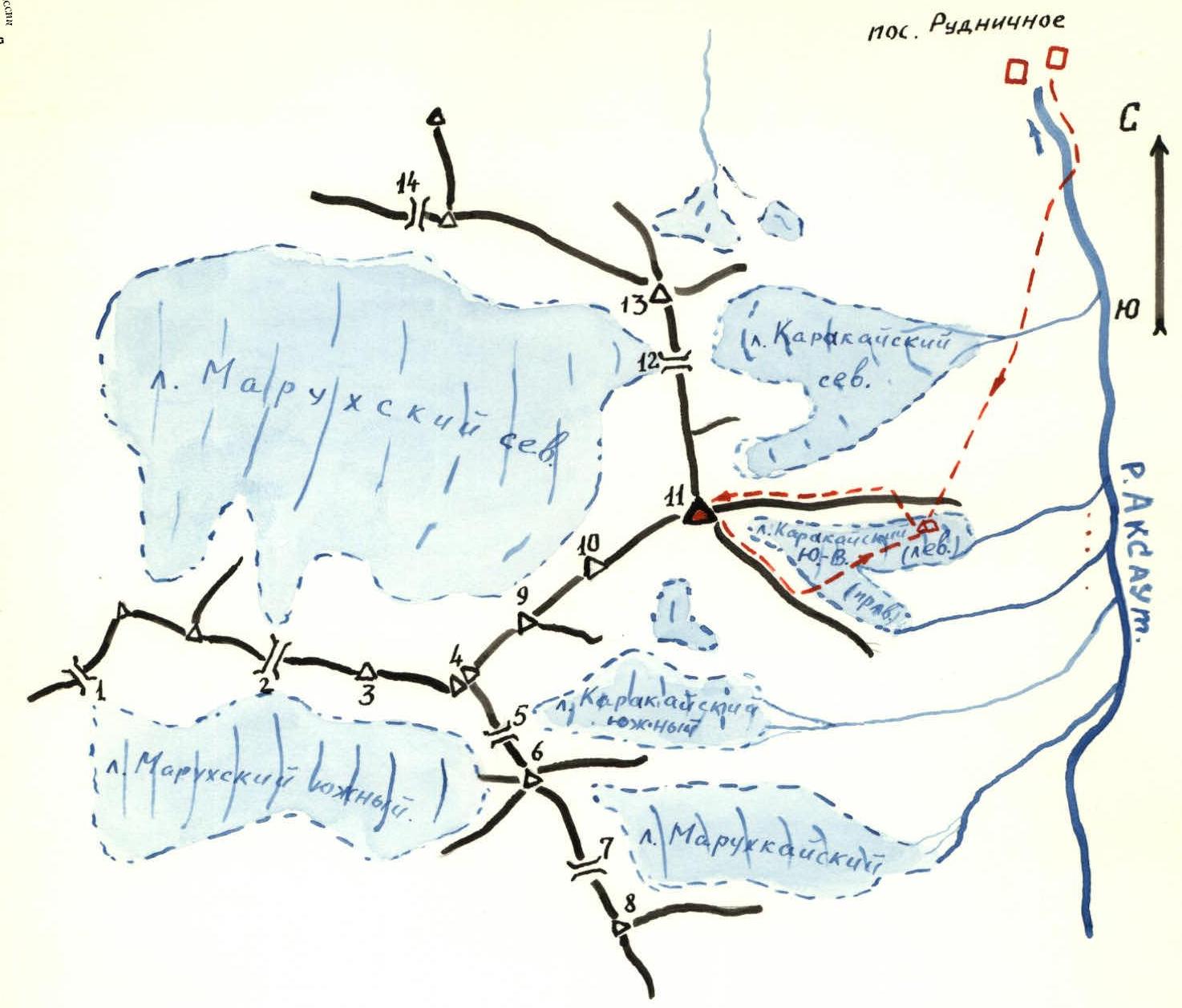
Legend for the map-scheme of the ascent area: Peaks: 3. Kara-Kaya West peak 4. Dvuushka peak 6. Marukh-bashi peak 8. Marukh-Kaya peak 9. Deito-Kaya peak 10. Proto-Kaya peak 11. Kara-Kaya Main peak 13. "Krasnaya gora" (Red mountain) peak
Passes:
- Marukhsky pass
- West-Karakai pass
- South-Karakai pass
- Marukhkai pass
- North-Karakai pass
- Khaleha pass
Map — scheme of the ascent area.
Brief Description of the Approach to the Route.
From Rudnichny settlement, cross to the left (orographic) bank of the Aksaut river, and follow the trail leading to the North Kara-Kai pass to the shepherd's huts. From the huts, move towards the gap in the Eastern ridge (landmark — geodetic sign near the gap). Cross the ridge through the gap and bypass part of the ridge along the scree on the southern side (path marked with cairns) to a bivouac under the South-Eastern Kara-Kai (left) glacier. From the bivouac, a convenient exit to the Eastern ridge in its lower third can be seen, via gentle slabs. From Rudnichnoe settlement to the bivouac — 3.5 hours.
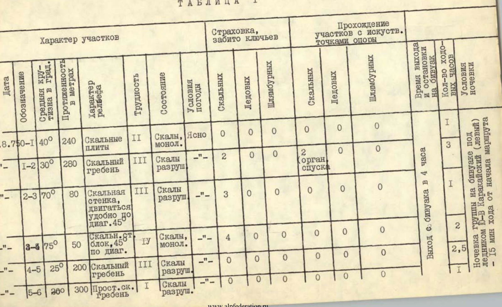
Table 1
| Date | Designation | Average slope, deg. | Length, m | Terrain character | Difficulty | Condition | Weather conditions | Insurance, pitons driven (rock) | Insurance, pitons driven (ice) | Insurance, pitons driven (bolted) | Passage of sections with artificial holds (rock) | Passage of sections with artificial holds (ice) | Passage of sections with artificial holds (bolted) |
|---|---|---|---|---|---|---|---|---|---|---|---|---|---|
| 8.08.1975 | R0–R1 | 40° | 240 m | Rock slabs | II | Rocks, monolithic | Clear | 0 | 0 | 0 | 0 | 0 | 0 |
| " | R1–R2 | 30° | 280 m | Rocky ridge | III | Rocks, broken | " | 2 | 0 | 0 | 2 (organized descent) | 0 | 0 |
| " | R2–R3 | 70° | 80 m | Rock wall, easy to climb diagonally at 45° | III | Rocks, broken | " | 3 | 0 | 0 | 0 | 0 | 0 |
| " | R3–R4 | 75° | 50 m | Rocky block, 45° diagonally | IV | Rocks, monolithic | " | 4 | 0 | 0 | 0 | 0 | 0 |
| " | R4–R5 | 25° | 200 m | Rocky ridge | III | Rocks, broken | " | 0 | 0 | 0 | 0 | 0 | 0 |
| " | R5–R6 | 20° | 300 m | Easy rocky ridge | I | Rocks, broken | " | 0 | 0 | 0 | 0 | 0 | 0 |
Departure from the bivouac at 4:00. Group overnight stay at the bivouac under the South-Eastern Kara-Kai (left) glacier — 15 minutes' walk from the start of the route.
Description of the Route
From the overnight stay, on the right (in the direction of travel) side of the glacier, avoiding crevasses, approach the rock slabs leading to the lowering in the ridge, the col. From the overnight stay to the exit onto the ridge takes 1 hour. Further movement along the ridge reveals several gendarmes. The first and second gendarmes are bypassed on the left via ledges in the upper and middle parts, respectively (rocks of moderate difficulty). The third gendarme is bypassed on the right with an exit onto the ridge. Then, moving along the left side of the ridge, reach the fourth gendarme. From a large boulder at the foot of the gendarme, a sporting descent of 3-4 m (piton with a loop) is made under a 10-12-meter wall (piton insurance), which leads to a gentle summit of the gendarme, where a control cairn is located (3 hours from the col). From the gendarme, a "Dülfer" descent of 5 m (piton with a loop) is made. Further, to the left and downwards along a simple ridge to the base of a 120-meter rocky wall of the tower. Up the wall (piton insurance), two ropes, but not vertically upwards, rather diagonally to the left at an angle of approximately 45-50° (live rocks, rocks of moderate difficulty), then 50 m to the right and left (pitons, key location, rocks above moderate difficulty) with an exit onto the summit of the tower. From the control cairn, 3-4 hours.
From the tower, along a sharp ridge, approach a descent of 3-4 m (sporting descent, loop) onto a col. From the col, on the right side of the ridge, with a transition to the left, move to a ledge. Having passed the ledge (about 30 m), go left along a gentle rocky couloir (live rocks) to exit onto a "summit table" of scree type. Further along the route, the path passes along a gentle scree ridge, which leads to the summit of Main Kara-Kaya, 7-8 hours from the control cairn.
Movement along the route includes:
- Ascent to the summit of Main Kara-Kaya
- Descent to the south-east along a Category 2B route
- Transition from the summit to the bivouac under the South-Eastern (left) glacier — 3-4 hours
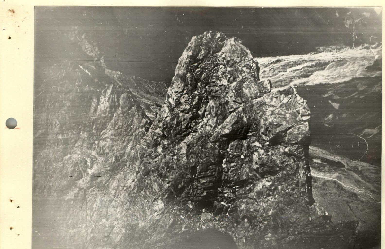
On the ridge (section R1–R2)
Comments
Sign in to leave a comment