
ASCENT DOCUMENT
- Ascent category — wall ascent
- Ascent region — Western Caucasus
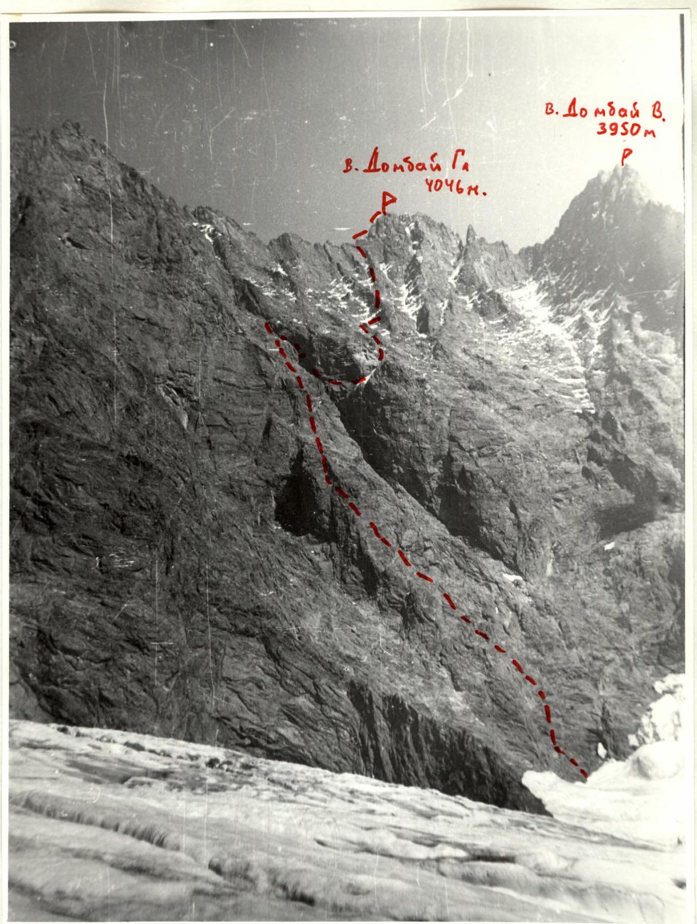
- Ascent to v. Dombay Glavny via the southern wall (4046 m) category 6B complexity. Korotkov's route.
- Wall section height difference — 800 m
total route length — 1660 m
section lengths:
- category 6 — 220 m
- category 5 — 720 m
- Average steepness of the wall section — 70–80°
- Pitons driven
Category Rock Ice Bolted Chocks Driven 4 0 2 220 Left 0 0 2 12 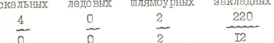
- Number of travel hours — 19 hours, days — 2
- Number of bivouacs — 1, sitting — 1
- Water or snow available along the entire route
- Team leader — Kadoshnikov N.G., team members — Yudin A.N.
- Team coach — Gorbachevsky Alexander Dmitrievich
- Route start — July 31, 1995 Reaching the summit Dombay Glavny — August 1, 1995 Return to base camp — August 1, 1995
- Ascent organized by the Krasnodar Kraisportkomitet.
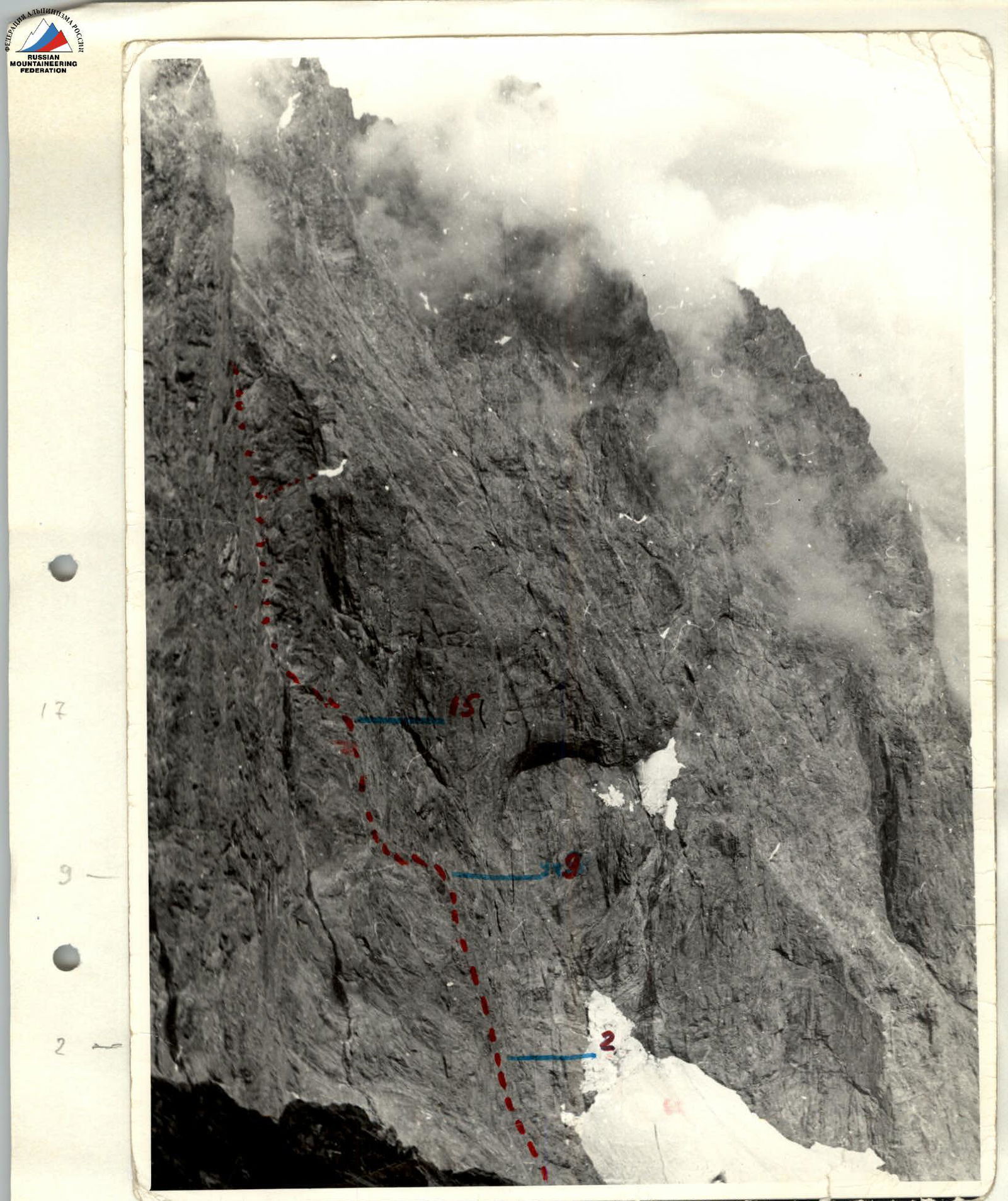
Photos of the ascent route
| Section | Pitons (rock) | Length (m) | Steepness (°) | Category |
|---|---|---|---|---|
| R0 | 40 | 65 | 5- | |
| R1 | 20 | 75 | 5 | |
| R2 | 30 | 85 | 6 | |
| R3 | 1 | 30 | 85 | 6 |
| R4 | 25 | 90 | 6- | |
| R5 | 25 | 40 | 5 | |
| R6 | 45 | 85 | 5 | |
| R7 | 65 | 55 | 3- | |
| R8 | 4 | 15 | 80 | 5- |
| R9 | 25 | 100 | 75 | 5- |
| R10 | 18 | 80 | 80 | 5- |
| R11 | 1 | 5 | 75 | 5 |
| R12 | 25 | 80 | 6 | |
| R13 | 25 | 85 | 6 | |
| R14 | 8 | 45 | 75 | 5- |
| R15 | 16 | 60 | 60 | 4- |
| R16 | 8 | 70 | 50 | 3 |
| R17 | 1 | 40 | 30 | 1 |
| R18 | 21 | 120 | 70 | 5 |
| R19 | 1 | 30 | 55 | 1 |
| R20 | 10 | 45 | 80 | 5 |
| R21 | 6 | 40 | 65 | 3 |
| R22 | 15 | 60 | 70 | 5- |
| R23 | 40 | 45 | 50 | 4- |
| R24 | 1 | 65 | 80 | 6 |
| R25 | 13 | 60 | 75 | 5- |
| R26 | 13 | 40 | 80 | 6 |
| R27 | 1 | 30 | 75 | 5 |
| R28 | 9 | 30 | 90 | 6 |
| R29 | 120 | 55 | 3-4 | |
| R30 |
Route description by sections
On average, the route is complicated by slab-like rocks sloping downward. The couloir and traverse of the trough are rockfall-prone. R0–R1: Start of the route — from the firn trough of the SE ridge of v. Dombay Zapadny. A shaded and slab-like wall with few holds. R1–R2: Climbing a complex wall between small overhangs. R2–R3: A wall with a tile-like structure and overhangs, A.I.D. R3–R4: Slab-like wall. R4–R6: Entering an internal corner via a vertical wall and climbing up it. R6–R7: A heavily dissected wall. R7–R8: Climbing non-steep slab-like rocks under an internal corner. R8–R9: Steep internal corner turning into a chimney. R9–R10: Slab-like red rocks. R10–R11: Traversing to the "edge" of the triangle to the left under overhanging black rocks. R11–R12: Climbing a 5-meter wall to a ledge under an overhang. R12–R14: Climbing a complex wall with a ledge in the middle, left of the overhang, upward, A.I.D. R14–R15: Climbing a slab-like wall, bypassing overhangs on the right onto slabs. R15–R17: Climbing moderately complex, steep, slab-like rocks onto the ridge crest. Control cairn. R17–R18: Climbing a gentle ridge under the edge. R18–R19: Climbing straight up the edge onto the flattening ridge. R19–R20: Climbing a simple ridge under the wall. R20–R21: Climbing a steep wall upward to a ledge on the right. R21–R22: Climbing a wall with a ledge to the right toward a couloir. R22–R23: Traversing to the right along a wide slab-like wall, crossing a stream, a couloir, and exiting to the edge of the trough. R23–R24: Climbing steep and slab-like rocks of the trough to the right and upward under the left buttress of v. Dombay Glavny. R24–R25: Climbing a smooth, difficult wall to a narrow ledge under a steep slab. R25–R26: Climbing the slab upward to a vaguely defined couloir. R26–R27: Climbing through the couloir straight up a very difficult wall to the edge of the k.f. R27–R28: Climbing straight along the edge under a vertical wall before exiting onto the ridge. R28–R29: Climbing a very difficult, overhanging wall to exit onto the ridge. R29–R30: Climbing to the right along the ridge to exit onto the summit.
Note. Almost the entire route is suitable for using friends, chocks, and other protection.
Photo of the initial route profile
ascent route R29, R15 — route sections
Comments
Sign in to leave a comment