REPORT
On the ascent of Mt. AMANAUZ Main via the South face, category 5B - (control and test route by B. Romanov), made by instructors at "Alibek" alpine camp Shklyaev E.V. and Smaglyukov S.E. on August 3-4, 1977.
Brief explanations for the table
The start of the route is easily recognizable. It is located at the intersection of a vertical line dropped from the "room" corner with the snow adjacent to the wall. Here, a monolithic outer corner goes up. Further movement is completely unambiguous and logical.
The first control point is located in the "room" corner on an inclined shelf. The overhanging walls were bypassed on the left side, where their extent is minimal.
The average steepness of sections R1-R4 approaches 78 °. Due to the monolithic and relief nature of the rocks, the first climber was able to ascend with a backpack. The backpacks were pulled up only on section 4.
At the end of section 5, there is a good bivouac site. Sections 6, 8, 9-11 are significantly more destroyed; there are large stones lying separately.
The second control point is located at the bivouac (section 8).
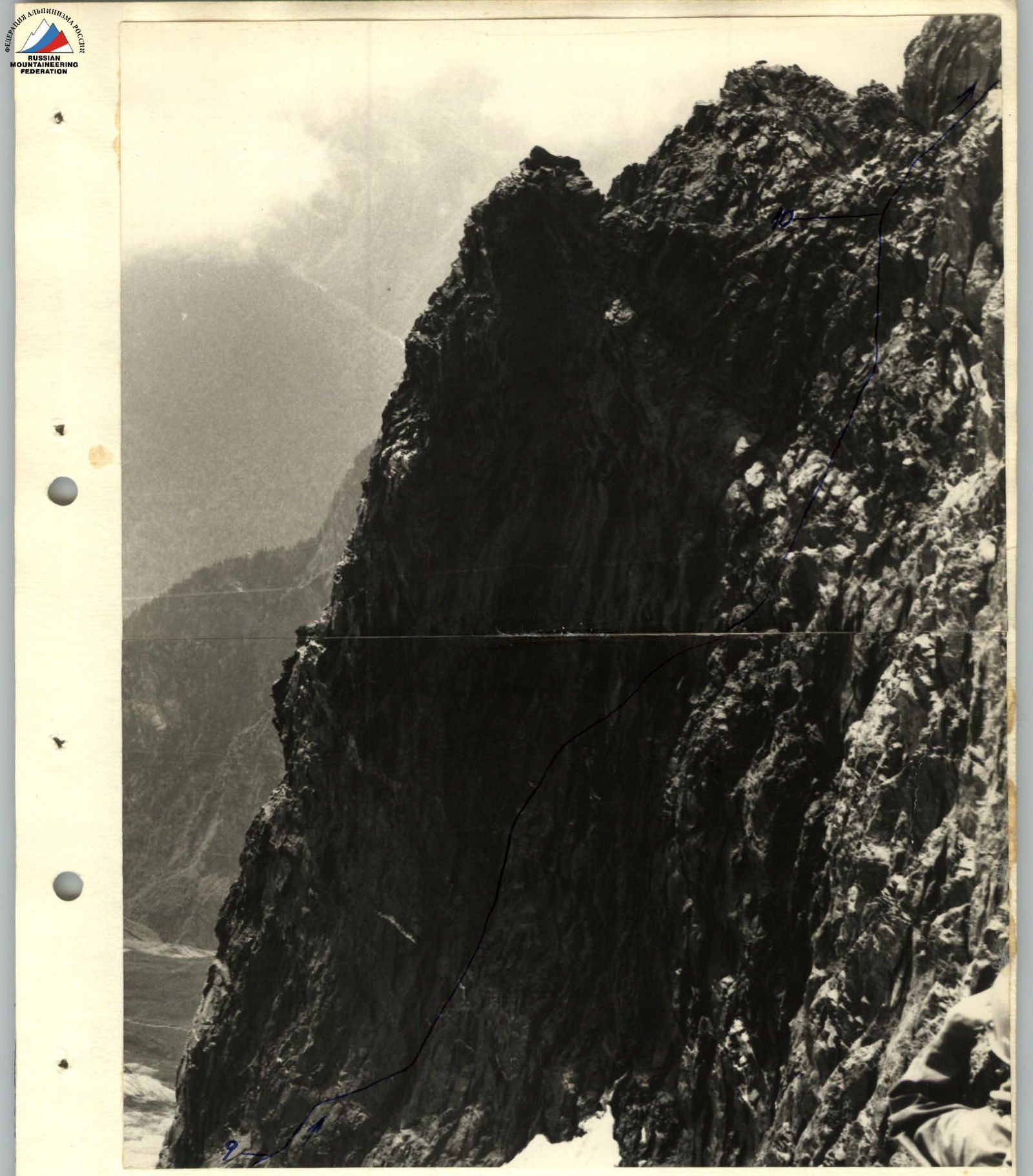
The path from the bivouac goes around the bifurcation of the South ridge to the right through the "black" wall, leading to its shoulder. Further, the path goes along the ridge.
The average steepness of the route is about 60 °. In general, the route can be divided into two parts: R1-R4 and R5-R11. The first part is significantly more complex and steeper, and its passage can be facilitated by preliminary processing of the wall's beginning.
The passage of sections R8-R11 was carried out in the conditions of search and rescue operations, which explains the low pace of the rope team's movement.
Table
Characteristics of the ascent sections on the control and test route 5B category (B. Romanov) to the summit of AMANAUZ Main via the South face.
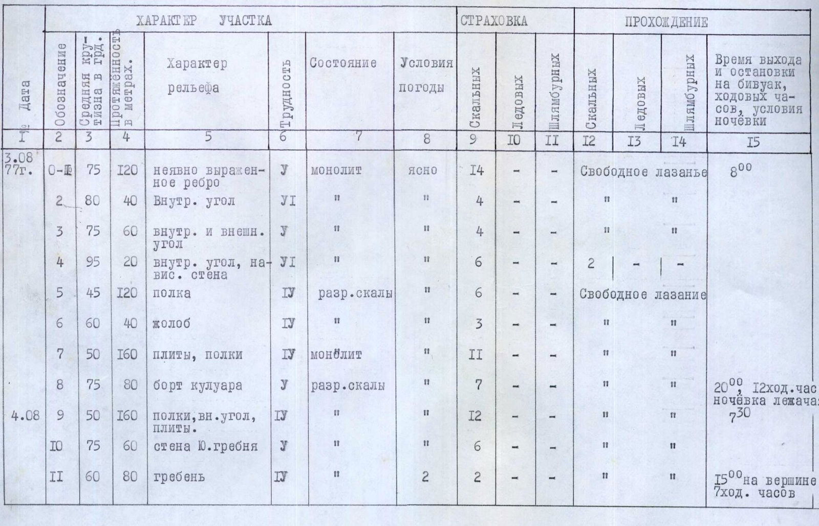
| Date | Designation | Average steepness in degrees | Length in meters | Terrain characteristics | Difficulty | Condition | Weather conditions | Rock | Ice | Bolted | Rock climbing | Ice | Bolted | Time of departure and stop for bivouac, climbing hours, bivouac conditions |
|---|---|---|---|---|---|---|---|---|---|---|---|---|---|---|
| 3.08 1977 | 0–11 | 75 | 120 | vaguely expressed rib | U | Monolithic | clear | 14 | — | — | Free climbing | — | — | 8:00 |
| 2 | 80 | 40 | Inner corner | VI | " | " | 4 | " | " | " | " | " | ||
| 3 | 75 | 60 | inner and outer corner | U | " | " | 4 | " | " | " | " | " | ||
| 4 | 95 | 20 | inner corner, overhanging wall | VI | " | " | 6 | — | 2 | " | — | — | ||
| 5 | 45 | 120 | shelf | IV | broken rocks | " | 6 | — | — | Free climbing | — | — | ||
| 6 | 60 | 40 | groove | IV | " | " | 3 | " | " | " | " | " | ||
| 7 | 50 | 160 | slabs, shelves | IV | monolithic | " | 11 | " | " | " | " | " | ||
| 8 | 75 | 80 | couloir edge | U | broken rocks | " | 7 | " | " | " | " | " | 20:00 12 climbing hours lying bivouac | |
| 4.08 | 9 | 50 | 160 | shelves, inner corner, slabs | IV | " | " | 12 | " | " | " | " | " | 7:30 |
| 10 | 75 | 60 | South ridge wall | U | " | " | 6 | — | — | " | " | " | ||
| 11 | 60 | 80 | ridge | IV | " | " | 2 | " | " | " | " | " | 15:00 at the summit 7 climbing hours |
Bypassing the ascent of the South ridge along the "black" wall (section 10). Photographed from "Dvuzubka".