ASCENT PASS
- Category of technical ascents.
- Dombay area, North-West Caucasus.
- Alibekskiy peak, ~3450 m, from the Belalakayskiy glacier along the edge or along the ridge from Kap peak.
- Cat. diff. – 1A.
- The nature of the route is combined, the height difference from the glacier is 500 m, in the second half of summer there are ice sections in the upper part of the route.
- Insurance – without the use of hooks.
- Number of travel hours from the bivouac on the moraine: ascent 4–5 hours, descent – 2 hours.
- Group is training:
| Participant | Rank |
|---|---|
| Starikov G.A. | 1st sports rank, instructor |
| Krutikov Yu. | 3rd sports rank |
| Koblyakov V. | 3rd sports rank |
| Rakhmatov R. | 3rd sports rank |
| Galimyanov N. | 3rd sports rank |
- Training part of Dombay alpine camp, Honored Coach of the USSR Ovcharov V.V.
- The description was compiled during the traverse of the peaks of the German-Austrian Komsomol for cat. diff., completed on August 2, 1976 (without counting the first ascent).
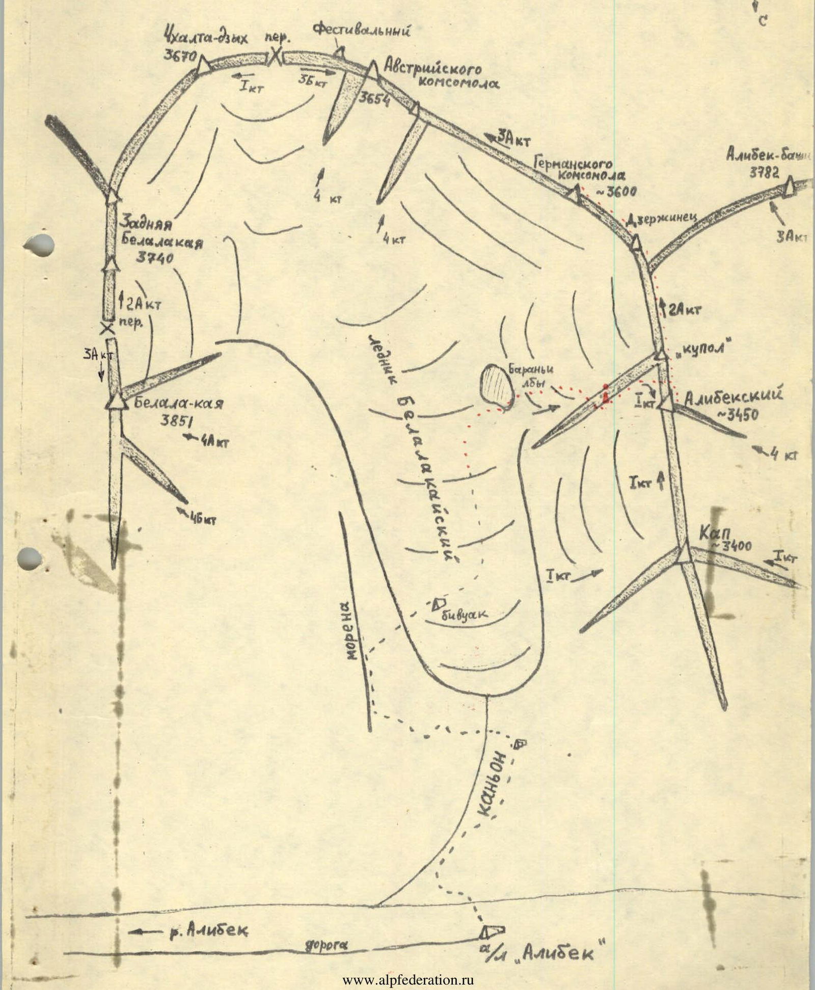
Map-scheme of the area
ASCENT DESCRIPTION
From Alibek camp along the trail to the waterfalls of the Belalakayskiy canyon – 0.5 hours. Through the forest along the steep trail on the right side of the canyon, ascent (in the upper part of the path through gentle rocks) to the sites of a large bivouac – another 1 hour. From here, the tongue of the Belalakayskiy glacier and the left lateral moraine are visible, along which it is necessary to reach the glacier. It is necessary to cross the river to the left along a snowy bridge or, in case of its unreliability or absence, climb over a large boulder-cork located a little downstream of the river. Then, along the grassy trail, rise to the moraine and along its ridge reach the glacier – another 1 hour. Here, on the median moraine, it is most convenient to settle for the night, since from here the beginning and almost the entire route of the upcoming ascent are clearly visible (photo 2).
From the overnight stay, forming rope teams, along the closed glacier, approach the beginning of the route and along the talus to the left of the stream, ascend upwards to the left to the red "ram foreheads" – 1 hour. Then, along the snowy slope (glacier), ascent with a turn to the right and exit along a steep snowy slope to the shoulder of the "edge". Here is a control cairn – another 1 hour. Along the rocky ridge, approach the snowy "dome"; having encountered a 10-meter destroyed rocky belt, overcome it on the left along the ledges with alternate belay. Along the snowy slope (in the second half of summer, ice is possible) ascent under the bergschrund of the "dome" and traverse to the right along it to a convenient transition and exit to the saddle of the main ridge between the "dome" and Alibekskiy peak (photo 3). To the right along the sharp ridge, ascent to the summit. From the control cairn – 1.5–2 hours. Descent along the ascent path to the moraine of the glacier takes 1.5 hours.
Recommendations: exit to the ascent no later than 4 am. In the second half of summer, have crampons for all participants.
Hazards:
- Rockfall hazard to some extent represents the upper section of the approach to the control cairn.
The description was compiled by Starikov G.A.