Ascent Passport
I. Climbing category: Rock climbing.
-
Climbing area, ridge: Western Caucasus, Main Caucasian Range, Awadkhara region.
-
Peak, its height, ascent route: Mt. Kardyvach Main, 3150 m, via the center of the South face.
-
Estimated difficulty category: 4B (winter).
-
Route characteristics: Snow, wall, 300 m elevation gain from the base of the wall, average steepness 65°.
-
Pitons driven:
| For belay | For artificial protection points | |
|---|---|---|
| Rock | 25 | 1 |
| Ice | 0 | 0 |
| Bolt | 0 | 0 |
-
Total climbing hours: From bivouac to summit – 9 hours.
-
Number of nights and their characteristics: One overnight stay on snow in a cirque below the route.
-
Participants:
-
Korostylev V.A. – 1st sports category – leader
-
Kuznetsov V.V. – Candidate for Master of Sports – participant
-
Melnik V.G. – 1st sports category
-
Karpyuk I.A. – 1st sports category
-
Team coach: Kobyakov V.P.
II. Date of departure and return: May 7, 1979.
Mt. Kardyvach Main is located in the Main Caucasian Range northeast of Lake Ritsa in the upper reaches of the Awadkhara River. The region's mild weather conditions, convenient access routes, and relatively short approaches make the peak interesting for mountaineers.
A classified route 4A category passes along the northwest ridge to Mt. Kardyvach Main, and a 2A category route goes along the southeast ridge. Between the 2A category route and the southwest buttress, along which a 3A category route passes, a logical path to Mt. Kardyvach Main is visible through the center of the south wall, approximately 4B category.
The first ascent of Mt. Kardyvach Main via the center of the south wall was made by a sports group from the ARFA alpine gathering. The group departed from the base camp at the Awadkhara sanatorium on May 6, 1979, at 13:00, heading up the Awadkhara River, and stopped at a bivouac in the upper cirque under the south wall of Mt. Kardyvach Main at 17:00. The ascent route was surveyed and photographed during preliminary reconnaissance.
The ascent was made on May 7, 1979, in ideal weather conditions during a low-snow winter. It is possible that the route's difficulty is higher than indicated under different weather conditions.
The description of the ascent route, necessary diagrams, tables, and documentation are provided below.
Route Description
Section # 1 (see table), 40 m, 65°
We ascend a steep snow slope from the bivouac to the base of the south wall of Mt. Kardyvach Main to the start of a ledge that leads from right to left up to a balcony. 10 m, moderate climbing, 1 piton.
From the balcony, we climb straight up to the summit of a rock triangle – challenging climbing, 30 m, 3 pitons. The first person climbs in crampons without a backpack. At the summit of the rock triangle is the 1st control point.
Section # 2, 60 m, 50–60°
From the control point, we move right along an inclined ledge to the start of a crack – 20 m, moderately difficult rocks, belay via projections, 1 piton.
Up the crack to the exit onto a ledge. Challenging climbing, piton belay, 30 m, 4 pitons.
Along the ledge, we traverse right under an overhang to the start of an internal angle. 10 m, belay via projections.
Section # 3, 60 m, 55°
Up the internal angle directly to the exit onto a terrace 60 m, challenging climbing, piton belay, 6 pitons.
Section # 4, 20 m, 40°
Up the terrace to the base of the summit pinnacle wall 20 m, belay via projections.
Section # 5 (key), 40 m, 80–90°
From under the base of the wall:
- From left to right along a diagonal ledge to the start of a crack that cuts through the wall – 12 m, challenging climbing, 3 pitons;
- Then up the crack directly to a distinct block – 20 m.
The transition from the diagonal ledge to the crack is challenging, using ladders. Up the crack – challenging climbing, piton belay, 4 pitons. We bypass the block on the left and exit onto a ledge. Along the inclined ledge, we traverse right 3 m to an internal angle. The transition to the internal angle is moderately difficult, belay via a projection. Up the internal angle – 3 m directly to a shoulder. Group reception point.
The key section is climbed first in crampons without a backpack.
Section # 6, 20 m, 55°
From the internal angle, along the left side of the crevice, we exit onto a wide short ledge. Control point. Good spot for an overnight stay. Moderate climbing. Caution: many loose rocks in the crevice. Belay via projections.
Section # 7, 40 m, 75°
From the control point directly up, staying on the right side of the crevice. Piton belay, 4 pitons, challenging climbing. We exit onto moderately difficult rocks.
Section # 8, 40 m, 50°
Along moderately difficult rocks – exit to the summit 40 m, belay via projections.
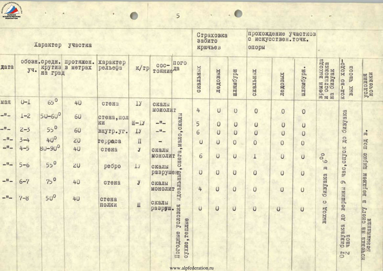
Summary Table of Sections
| Date | Section | Average Steepness (°) | Length (m) | Terrain Characteristics | Cat. | Condition | Belay: Rock | Belay: Ice | Belay: Bolt | Aids: Rock | Aids: Ice | Aids: Bolt |
|---|---|---|---|---|---|---|---|---|---|---|---|---|
| May | 0–1 | 65 | 40 | wall | IY | solid rock | 4 | 0 | 0 | 0 | 0 | 0 |
| " | 1–2 | 50–60 | 60 | wall, ledges | Ш–IY | –"– | 5 | 0 | 0 | 0 | 0 | 0 |
| " | 2–3 | 55 | 60 | internal angle | IY | –"– | 6 | 0 | 0 | 0 | 0 | 0 |
| " | 3–4 | 40 | 20 | terrace | П | –"– | 0 | 0 | 0 | 0 | 0 | 0 |
| " | 4–5 | 80–90 | 40 | wall | У | solid rock | 6 | 0 | 0 | 1 | 0 | 0 |
| " | 5–6 | 55 | 20 | ridge | 1У | broken rock | 0 | 0 | 0 | 0 | 0 | 0 |
| " | 6–7 | 75 | 40 | wall | У | solid rock | 4 | 0 | 0 | 0 | 0 | 0 |
| " | 7–8 | 50 | 40 | wall, ledges | Ш | broken rock | 0 | 0 | 0 | 0 | 0 | 0 |
Weather conditions: ideal, little snow, dry rocks, warm.
Summary Climbing Data
- Departure from bivouac: 6:00
- From bivouac to summit: 9 hours
- Descent to bivouac: 2 hours
- Overnight stay on snow: in the upper cirque below Mt. Nameless