Description
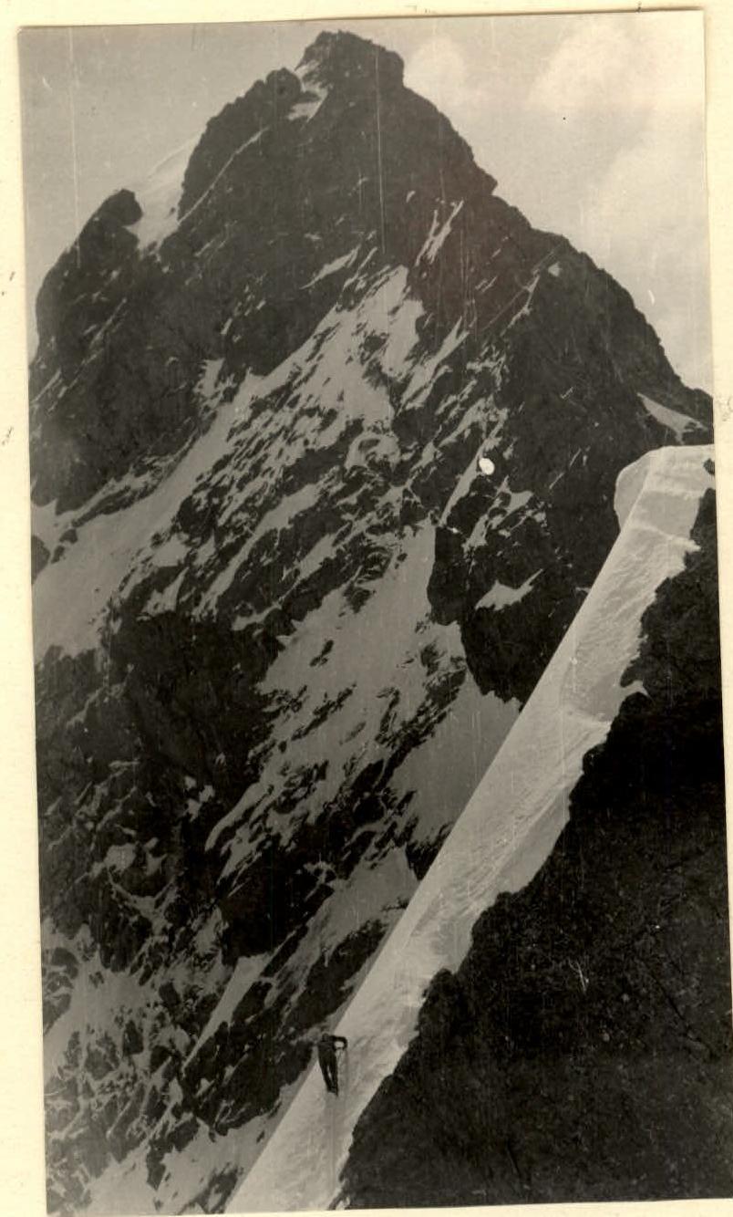
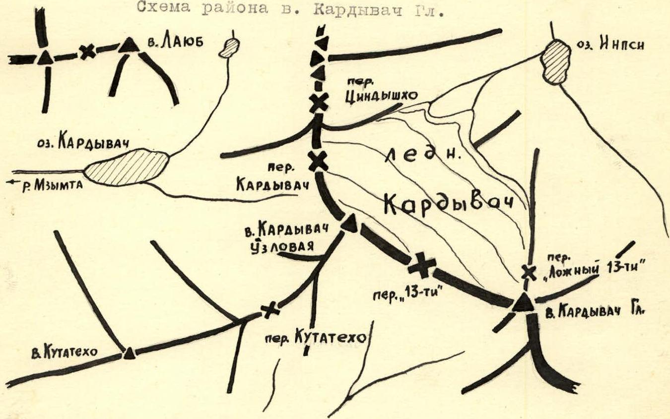
The route of the first ascent via the Northwest Ridge to the summit of Kardyvach Glavnaya (3105 m) - approximately Category 4B difficulty - was climbed by a group of climbers from the Krasnodar City Section of Alpinism under the DSO "TRUD" in May 1970. The Kardyvach Glavnaya peak, with an elevation of 3105 m, is located on the Main (Watershed) Ridge, near the junction of the Main and Gagra ridges in the area of Kardyvach-Ritsa lakes.
The peak is a rocky-snowy dome with a sharp shoulder extending to the northwest, which then turns into a ridge.
The described ascent route goes from the "13-ti" pass along the northwest ridge.
Route Characteristics
The route is rocky-snowy, mainly ridge-like, and surpasses routes like:
- Dubll-peak
- Adai-khokh
- Ullu-auz
- Koshtan-tau via the NE ridge
in terms of terrain complexity and slope steepness, and is comparable to routes like:
- Bezymyannaya
- Amanauz
- Dombai-Ulgen
completed by the group members. The height difference from the "13-ti" pass to the summit is approximately 650–700 m, and the route length from the "13-ti" pass to the summit is about 1200 m.
Approaches to the Summit
-
From Gagra to Ritsa Lake by bus (regular or tourist) or by hitchhiking, 3–4 hours, then 17 km on foot or by hitchhiking to the Avadhara resort. From Avadhara resort, follow the river upstream along the road, then turn right along the trail towards the Kardyvach Glavnaya peak. The "13-ti" pass is located in the Kardyvach massif between the Glavnaya (right) and Uzlovaya (left) peaks. The ascent to the pass is via a 30–40-degree snowy couloir (beware of rockfall). From Avadhara resort to the "13-ti" pass, 5–6 hours.
-
From Adler, take a bus to Krasnaya Polyana (55 km). From Krasnaya Polyana, hitchhike to Narzan sources (18 km). From the sources, follow the trail upstream through the Gruppovoy pass, then up the Mzymta river to Kardyvach Lake. The journey from Narzan sources to Kardyvach Lake takes 1–1.5 days. From Kardyvach Lake, follow the Sineozernogo stream upstream, traverse the grassy slopes, avoiding the rocky outcrops on the left, then continue along the talus and snowfield to the Kardyvach pass - 3–4 hours. From the pass, descend into the Kardyvach glacier cirque and traverse right along the slopes of the Kardyvach Uzlovaya peak to the "13-ti" pass - 2 hours. The ascent to the "13-ti" pass via a gentle snowy slope takes an additional 1 hour.
-
From Psebay settlement, hitchhike to the "3rd rota" cordon, then follow the trail upstream along the Malaya Daba river through the Umpyr shelter to the mouth of the Tsakhvoa river. Continue along the trail upstream along the Tsakhvoa river to Inpsi Lake. From Inpsi Lake, head northwest through the gorge towards the Kardyvach pass and Tsyndyshko pass until you reach a large rocky ridge dividing the gorge; turn left and enter the Kardyvach glacier cirque. From the Kardyvach glacier, ascend to the "13-ti" pass. The journey from the "3rd rota" cordon to Inpsi Lake takes 2 days, and from Inpsi Lake to the "13-ti" pass, 3.5–4 hours.
The "13-ti" pass is a broad rocky ridge, snow-covered on the northeastern side. There are bivouac sites (for up to 2 tents) on the pass or 200–250 m southeast on a snowy patch. Water is available from snow.
Ascent Route Description
From the "13-ti" pass, follow the rocky ridge to the first sentinel. A wide snowy shelf lies to the right. The sentinel is bypassed:
- right along the snowy shelf for 60 m;
- then up 20–25 m to the ridge.
Insurance is provided through outcrops. Along the ridge, 100–150 m (simultaneous movement) to a 10-meter rocky wall. The wall is climbed slightly left - upwards. Insurance is provided by pitons and outcrops. Exit to the ridge. First control cairn. From the "13-ti" pass - 2 hours 30 minutes.
Along the ridge (with snowy drifts on the left), 120–130 m to a steep 50–60-degree snowy ascent on the north side of the ridge. Up the snowy ascent, 50 m to a gentler ridge, becoming almost horizontal.
Then, 100–150 m along the ridge (alternating rocky and snowy sections) to a rocky wall rising sharply above the ridge. From the first control cairn, 1–1.5 hours. From the ridge:
- right along a small shelf, 3–5 m;
- up difficult rocks towards the rust-colored rocks, 50–60 m.
The rocks are heavily destroyed; thorough piton insurance is required. The sentinel is overcome on the right along a rocky shelf, 10–15 m. Then:
- Down an inclined internal corner with ice accretion into a couloir, 5 m. Insurance through outcrops.
- Up the couloir, 15–20 m, with a steepness of 40–50°.
To a snowy saddle between the sentinel and the summit shoulder. Insurance through ice axe and adjacent rock outcrops. Beware of rockfall. From the first control cairn, 3.5–4 hours.
From the saddle, up complex, destroyed rocks, 100–120 m, to a small icy couloir. The wall's steepness is 80–85°, with some sections reaching 90°. Thorough insurance through pitons and outcrops is required. At the top section:
- Cross the couloir to the right;
- Move towards a large rocky outcrop.
Ice accretion, step-cutting, and thorough insurance through pitons and adjacent rock outcrops are required.
From the rocky outcrop, right - upwards, crossing rocky gullies on heavily destroyed rocks, 100 m, to the pre-summit shoulder. Thorough, alternating insurance. 2nd control cairn.
From the snowy saddle to the 2nd control cairn, 4–4.5 hours. Along the pre-summit shoulder, 250–300 m, to a 3–4-meter rocky wall. The ridge is very sharp, with narrow dips, and is snow-covered on the north side. Thorough, alternating insurance through outcrops. The wall is climbed directly, then exit to a small snowy saddle separating the shoulder from the summit.
From the saddle, down a 40–45° snowy slope to the summit, 20–25 m. From the 2nd control cairn, 2 hours.
Descent from the summit is via a steep 50–60-degree snowy slope to the north, towards the "Lozhny 13-ti" pass. Thorough insurance through ice axe is required. The slope flattens after 300–350 m into a snowy ridge, ending 400 m later at a rocky wall on the "Lozhny 13-ti" pass. It's better to descend to the pass by going right (downhill) onto a gentler snowy slope and traversing it left to reach the pass. Descent from the summit to the pass takes 2.5–3 hours.
From the "Lozhny 13-ti" pass, descend into the Kardyvach glacier cirque via a 30–35-degree snowy slope (locally up to 45°) and then to a bivouac on the "13-ti" pass - 2 hours 30 minutes.
On the route, the following insurance equipment was used:
- Rock pitons - 12 pieces
- Ice pitons - 2 pieces (used as rock pitons)
- Wooden wedges - 1 piece
- Aluminum wedges - 3 pieces
Group Composition
- Kovyakh Konstantin Alekseevich - 1st category - leader
- Litvinov Boris Vladimirovich - 2nd category
- Gorbachevsky Alexander Dmitrievich - 2nd category
- Shutov Sergey Trofimovich - 2nd category
Recommendations for the Route
- Group size - no more than 4 people.
- Initial bivouac - on the "13-ti" pass.
- Departure time from the bivouac - 4-5 am.
- Equipment: a) Main rope 2×40 m; b) Expendable cordelette - 10 m; c) Rock pitons - at least 14 pieces, including petal-shaped, aluminum, and wooden wedges; d) Rock hammers - 2 pieces; e) Ice axes - one per person; f) Crampons - 1 pair.
Route description compiled by Shutov S.T.