Ascent Passport
I. Ascent class - rock II. Ascent area - Western Caucasus, Arkhyz, Sofiyskiy ridge between the upper reaches of the Sofia and Ak-Ayry rivers III. Peak, route - "Pazardzhik" (proposed by the first ascenders), 3184 m, via the North couloir and West ridge IV. Estimated category of difficulty - 2B V. Route description - combined, via a snow-ice couloir and a rocky ridge, height difference 590 m, average steepness of the couloir - 45°, ridge - 35° VI. Pitons used - 2 ice screws, 6 rock pitons VII. Duration - approximately 9 hours VIII. Number of overnight stays - not required on the route IX. Ascent leader - Zaporizhchenko E.V. - Candidate for Master of Sports, instructor X. Participants - Smerchanskiy V.A. - 1st sports category, Gavrilov I.V. - 1st sports category, Sokolov A.V. - 1st sports category, Sokolenko I.N. - 1st sports category XI. Team coach - Master of Sports of the USSR Popov V.P. XII. Date of departure and return - September 12, 1981
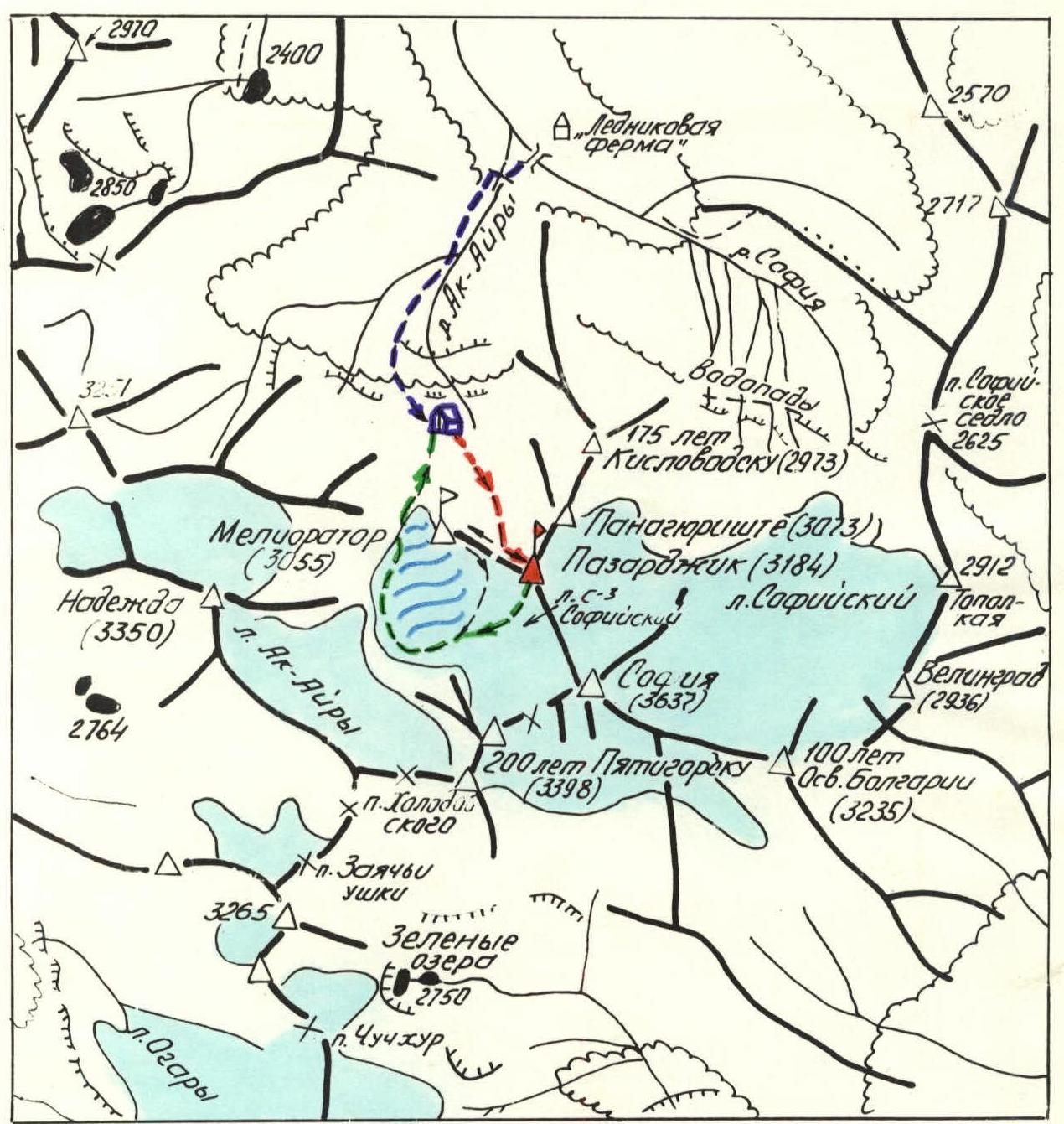
Legend:
- Path to the base camp
- Ascent route to peak "Meliorator" (~2B category of difficulty)
- Descent route from peak "Meliorator"
- Ascent route to peak "Pazardzhik" (~2B category of difficulty)
- Descent route from peak "Pazardzhik"
- Base camp location
The ascent to the previously unnamed peak was preceded by thorough reconnaissance carried out by climbers from the Stavropol regional federation in autumn 1979, spring 1980, July 1980, when they made first ascents to peaks "200 years of Pyatigorsk" and "Panagyurishte" (reconnaissance of paths from the north and west), and in October 1980, when the ascent route from the east was specifically scouted.
The simplest route appeared to be from the north, via a snow-ice couloir separating the massif of the unnamed peak from peak "Meliorator" to the west, and then along the western ridge, observed during the first ascent to peak "Meliorator" on September 11, 1981.
To the northeast and south, the massif of the unnamed peak drops off with slopes of average steepness:
- ≈ 70° (northern walls),
- ≈ 55° (southeastern edge with 20–40 m walls),
- ≈ 65° (southern, ruined walls).
To the south and east, the peak is outlined by bergschrunds of the "NW and NE Sofiyskiy" glaciers. In close proximity, separated by these glaciers and a narrow ridge dividing them, lies peak Sofia - the highest point in the area (3637.4 m).
The unnamed peak is a nodal point for the northern and eastern spurs of the Sofiyskiy massif. It is shown on all topographic maps and has, according to the latest 1:25,000 scale plans, an absolute elevation of 3184 m. Nearby climbing objects and routes:
- to peak "175 years of Kislovodsk" - 1B category of difficulty (2973 m);
- to peak "Velingrad" - 3B category of difficulty (2936 m);
- to "Panagyurishte" (3073 m, 2B category of difficulty, climbed but not yet classified);
- to peak "Meliorator" (3055 m, 2A category of difficulty, climbed but not yet classified);
- to peak "200 years of Pyatigorsk" - 1B category of difficulty (3398 m);
- to peak Sofia - 3A category of difficulty.
The group of climbers found no signs of human presence on the unnamed peak - the summit cairn was built by them for the first time.
A possible explanation for this is the apparent difficulty of the ascent, which, however, only delayed the inevitable first ascent to the peak as part of the systematic climbing development of the area by the regional federation.
The group requests the Classification Commission of the All-Union Federation to support the proposal to name the peak "Pazardzhik" in honor of the Bulgarian twin city of Stavropol region.
The first ascent to peak "Pazardzhik" was made by a group of Stavropol climbers during the "Arkhyz-81" alpinada organized by the Stavropol Regional Sports Committee, dedicated to the 1300th anniversary of the Bulgarian state.
The initial bivouac is a flat area above the last (upper) belt of "ram's foreheads" (barranьи лбы), down which the Ak-Ayry river flows.
The path to the bivouac from the "Glacier Farm" on the Sofia river (1920 m), taking about 3 hours, is described in the report on the first ascent to peak "200 years of Pyatigorsk". It starts from a wooden bridge across the mouth of the Ak-Ayry river, just above its confluence with the Sofia river, and goes along the left (orographic) slopes of the valley of this river to the amphitheater of steep slopes and rocks, from which a series of beautiful waterfalls cascades down in the second half of summer.
Further, the route:
- turns left (in the direction of travel);
- traverses with an ascent grassy slopes;
- ascends to the belts of "ram's foreheads";
- then, to the right, up the "foreheads" steeply to a flat area in a moraine.
Here is the bivouac. The area is not clear of snow (mainly avalanche snow) until the end of July, and not every year.
Views:
- straight ahead - the northwest wall of peak "Meliorator";
- to the right, in the distance - the northwest buttress of peak "200 years of Pyatigorsk";
- to the left - peak "Pazardzhik", peaks "Panagyurishte" and "175 years of Kislovodsk" (photo 1).
From the bivouac to the start of the route, there is a short 150-meter approach across a snow-filled depression with a very slight ascent. The direction is towards the middle part of the northwest wall of peak "Meliorator". The wall is somewhat oriented to the west and more precisely has a north-northwest exposure. Under the wall (2595 m) is the start of the route.
Route Description
Section R0–R1. (see table, photo 2) Up to the left, in rope teams, across a snowfield with a steepness of ≈ 30° to the left, northeastern edge of the wall. The snow is hard and dense in the morning hours, movement is on crampons. At the edge of the wall is the mouth of the couloir.
Section R1–R2. The entire section is a steep snow-ice couloir. It should be called a couloir only as a courtesy to climbing terminology. In fact, it is a large fault cutting through the granito-gneiss and granite massif. The walls of the fault-couloir are close to vertical, on the left (in the direction of travel) they are composed of granito-gneiss, on the right - mainly granite. The width is up to 15 m. The fault-couloir is filled with ice, on which a compacted snow cushion is retained until the end of July. Movement is on crampons. Here and below, intermediate points on the route are marked according to the altimeter readings on September 12, 1981.
Alternate belaying, using an ice axe (obviously only in the first half of summer) and ice screws. The group used ice screws for belaying where the snow cover was thin (belaying using rock pitons on the walls of the couloir is less convenient). Steepness at the start is ≈ 40°, from a point with an absolute elevation of 2775 m ≈ 45°. From this point, the "Sloping Gendarme" on the ridge is clearly visible ahead. It is safest to move along the right (in the direction of travel) side of the fault-couloir. The "Sloping Gendarme", to which the fault-couloir leads, divides the ridge into two depressions. The right one is the lowest (photo 3). Absolute elevation - 2925 m. From the ridge, there is a view of the northern slopes of peak Sofia. Below is the glacier. On the ridge, during the previous ascent to peak "Meliorator", a control cairn was built. To the right of the ridge, towards peak "Meliorator", goes a narrow ridge - a combination of dips and low walls; to the left of the "Sloping Gendarme" is a slightly overhanging wall of the western ridge of peak "Pazardzhik". From the start of the route to the "Sloping Gendarme" takes 3.5–4 hours.
Section R2–R3. The "Sloping Gendarme" is bypassed on the left, with an exit under the Eastern ridge and the base of the wall. Further movement continues, bypassing the wall on the right, across individual ledges with an ascent at an angle of ≈ 25°, about 80 m with careful alternate belaying using outcrops or pitons. At the same time, it is necessary to cross the first couloir and exit into the second (after the "Sloping Gendarme") with snow patches. 2965 m. Photo 4.
Section R3–R4. Straight up, through the couloir, quite complex climbing from one wall to another, h ≈ 80 m, steepness 70–75°. Belaying is using pitons and natural outcrops and flakes, each of which must be tested beforehand - the degree of destruction is significant. Exit to a horizontal area on the ridge with an absolute elevation of 3045 m, 40 m beyond the summit tower of the wall. This section is the key point of the route!
Section R4–R5. Directly along the narrow ridge with numerous dips or slightly to the right of it - alternate movement with belaying using outcrops, ≈ 420 m with an ascent of 140 m. Several indistinct gendarmes are passed on the right and upwards through crevices, with an exit back onto the ridge. The first (from R4) double gendarme is simpler to bypass on the left. The final 40 m of movement on snow lead to the summit (photo 5). From the ridge at the "Sloping Gendarme" to the summit takes 2–2.5 hours. The cairn is built for the first time.
Section R5–R6.
Facing peak Sofia, the descent begins down and to the right through a eroded (insufficiently defined) couloir starting from the pre-summit depression on the ridge.
Descent along the ridge to the southeast is significantly more complex (see photo 6):
- About 300 m of vertical cautious movement with alternate belaying
- Transition from one narrow, ruined ledge to another, to the south
- Exit onto the "NE Sofiyskiy" glacier
At the boundary between the rocks and the glacier is a bergschrund. At the beginning of summer, there are several snow bridges across it; in the second half of summer, crossing the bergschrund becomes more complicated.
Further movement is along the glacier, bypassing peak "Pazardzhik" and peak "Meliorator" and exiting under the slopes of peak "200 years of Pyatigorsk". The latter is necessary to descend onto the moraines of the Ak-Ayry glacier, leading to the bivouac, along the relatively gentle part of the "NW Sofiyskiy" glacier (photo 7), bypassing the icefall at its tongue. The ascent from bivouac to bivouac took the group 8.5 hours.
At a debriefing held in the presence of the head of the rescue service, the release officer, and participants in the event, the first ascent was assessed as corresponding to a rock route of 2B category of difficulty.
RECOMMENDATIONS:
- Group size 4–6 people.
- Requires 2–3 ice screws and 4–5 rock pitons.
Leader E.V. Zaporizhchenko
Pyatigorsk, September 30, 1981
TABLE
of the main characteristics of the ascent route to peak "PAZARDZHIK"
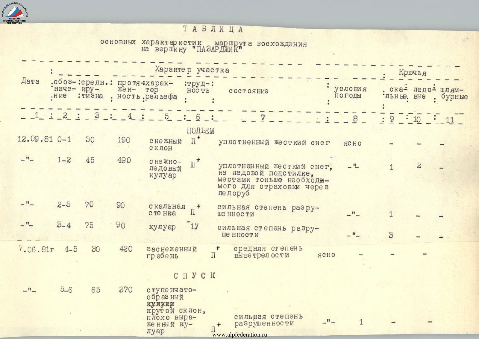
| Date | Section | Average steepness | Distance | Character of terrain | Difficulty | Condition | Weather conditions | Rock pitons | Ice screws | Drill holes |
|---|---|---|---|---|---|---|---|---|---|---|
| ASCENT | ||||||||||
| September 12, 1981 | R0–R1 | 30° | 190 m | Snow slope | 1 | Compacted hard snow | Clear | — | — | — |
| September 12, 1981 | R1–R2 | 45° | 490 m | Snow-ice couloir | 3 | Compacted hard snow, on ice substrate, in places thinner than necessary for belaying with ice axe | — | 1 | 2 | — |
| September 12, 1981 | R2–R3 | 70° | 90 m | Rocky wall | 1 | High degree of destruction | — | 1 | — | — |
| September 12, 1981 | R3–R4 | 75° | 90 m | Couloir | 4 | High degree of destruction | — | 3 | — | — |
| June 7, 1981 | R4–R5 | 30° | 420 m | Snow-covered ridge | 1 | Average degree of weathering | Clear | — | — | — |
| DESCENT | ||||||||||
| June 7, 1981 | R5–R6 | 65° | 370 m | Stepped couloir, steep slope, poorly defined couloir | 1 | High degree of destruction | — | 1 | — | — |