-
Climbing category: Rock climbing.
-
Climbing area: Arkhyz, Stavropol Krai, from Kardyvam mountain area to Marukh pass.
-
Peak, its height, and ascent route: 60-let VLKSM, 3400 m, via the left buttress of the eastern wall.
-
Estimated difficulty category: 2B.
-
Route characteristics:
Height difference — 800 m, average steepness — 60–65°, route length:
K.T.R. 1 2 3 4 5 6 M 153 650 100 - - - -
Number of pitons:
For belaying For creating I.T.O. rock 16 ice none bolt none -
Number of travel hours: 10 hours.
-
Number of nights and their characteristics: none.
-
Surname, name, patronymic of the team leader and participants, their sports qualification:
GORDA RUSLAN ALEKSANDROVICH — Master of Sports FEDOROV BORIS VASILYEVICH — 2nd sports category KUDERKIN NIKOLAI SEMENOVICH — 2nd sports category ANKOV ALEKSANDR YUREVICH — 2nd sports category
-
Team coach: GORDA R.A.
-
Date of departure and return: September 20, 1978.
Description
First ascent of peak 60 let VLKSM via the left buttress of the eastern wall, approximately 2B category.
From the base camp located on the upper edge of the forest on the right (orographic) bank of the Amanauz River, move up the gorge through birch, raspberry, and rhododendron thickets. After the thickets end, cross to the left (orographic) bank of the Amanauz River via snow bridges.
Then, with a gradual gain in height, reach a large scree, behind which lies the upper cirque of the gorge. Move up the scree, then across steep snow, and again across scree to reach a small moraine lake. The journey from the camp takes 4 hours.
From the lake, move up and to the right across steep moraine (about 35°), then across a glacier with a steepness of 30–35°, to reach the rocks located to the right of a snowy couloir. The journey from the lake takes 1 hour.
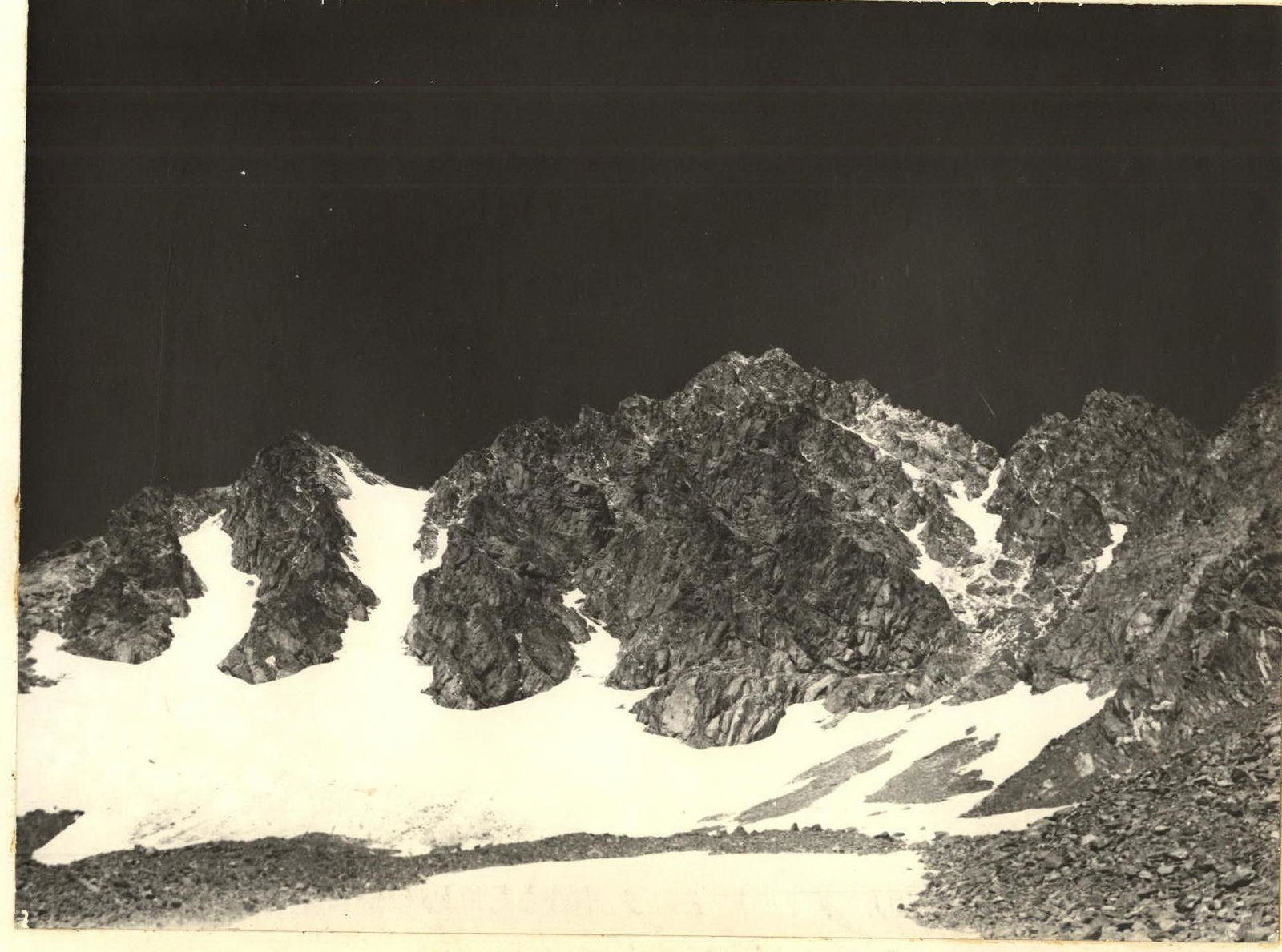
The route begins with entering a narrow snowy couloir and overcoming a bergschrund. Move up the couloir for 70–80 m at a steepness of 45–50°. Then, turn right and climb up a snowy couloir with a steepness of 50–55° for 100 m, exiting below the wall. The wall is an indistinct internal angle about 60–70 m high. Climb the wall directly with piton belays (10–12 pitons). Climbing is difficult. The rocks are wet due to a stream running down the wall. After the wall, there is a steep internal angle that goes up and to the left at a steepness of 70–75°. The steepness of the climbed wall was 80–85°. Move up the internal angle with piton belays for about 30 m, after which it becomes less steep (60°) and wider. After 20 m, exit below a 10-meter heavily destroyed wall. After the wall, climb a 30-meter internal angle with a stream running through it. Initially, the angle is 70–75° steep, but it becomes less steep (65–60°) later on. Then, climb 3 m up simple rocks to reach a platform. There's a control cairn on the platform!!!
From the cairn, move 30 m across a steep scree shelf that leads to a 10-meter wall with a steepness of 70–75°. Climbing is moderately difficult with piton belays. After the wall, the path goes across a steep scree shelf — 10 m — that leads to a platform. From the platform, move left up a steep (65–70°), 30-meter internal angle — climbing is moderately difficult. Then, the angle widens and becomes less steep, leading to a broad ridge covered in snow after 30 m. The ridge is about 70 m long. Further, exit onto a simple ridge, which after 400 m leads to the summit. The height is 3400 m.
Descent is via a broad ice-snow couloir to the left of the ascent route. The ascent takes 6 hours. Descent to the glacier takes 1.5–2 hours.
Recommended equipment: a 30-meter main rope, 10–12 rock pitons, 2–3 ice axes, 14–16 carabiners, crampons.
289
Organization website and cartography www.alpfederation.ru↗
 Upper part of the wall
Ascent route control cairn
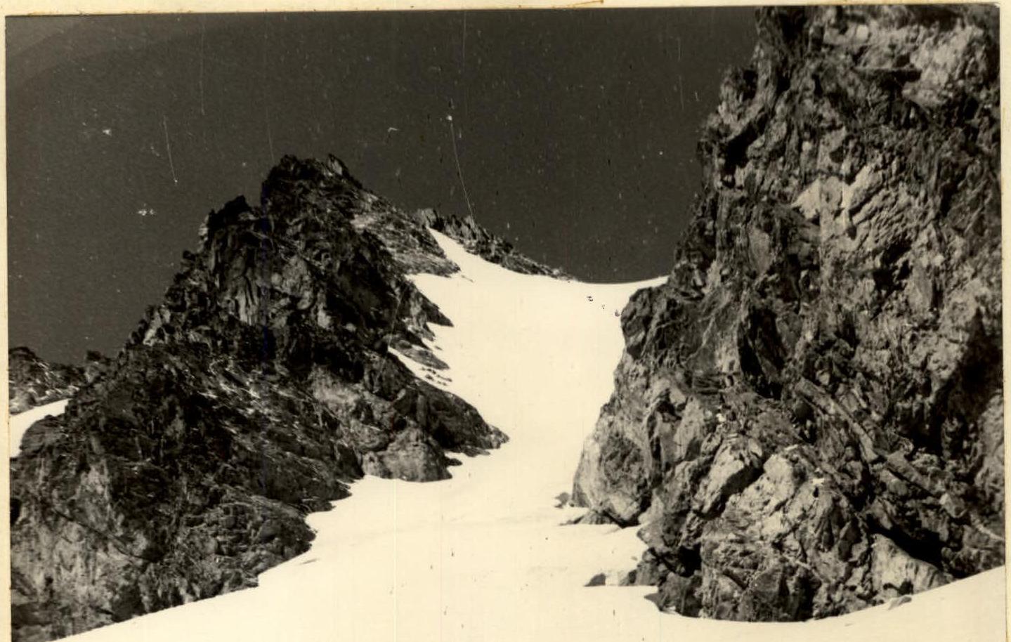
Upper part of the wall
Ascent route control cairn
Description
First ascent of the unnamed peak, named "peak 60 let VLKSM", via the center of the eastern wall, approximately 3B category.
From the base camp on the right (orographic) bank of the Amanauz River at the upper forest boundary, move up the gorge through birch groves, willow thickets, and rhododendrons, followed by crossing to the left (orographic) bank via snow bridges.
Then, gradually gain height and reach a large scree slope, behind which the upper cirque of the gorge is located. Move up the scree, across steep snow, and again across scree to a small moraine lake. The journey from the camp takes 4 hours.
From the lake, move up and to the right across steep moraine (about 35°), then across a glacier with a steepness of 30–35°, to reach the rocks between two very broad couloirs. When approaching the rocks, overcome a wide randkluft.
The route begins with a 15-meter inclined chimney leading to a narrow snow-filled couloir. Climb the couloir directly for 60 m (30–35°) to a 5-meter wall. After the wall, move left along a 20-meter shelf to a platform under a 30-meter wall. The wall has a steepness of 75–80° and is climbed to the right and up, overcoming two small overhangs. Belays are via pitons!!! The rocks are above average difficulty and are composed of durable rock.
After the wall, move left 6–8 m across slabs to exit under an internal angle on a shoulder. There are good protrusions for belays.
Then, climb a 20-meter internal angle with a steepness of 80–85° directly. Climbing is challenging. Belays are via pitons!!!
After overcoming this difficult section, exit under a sheer 15-meter wall. The internal angle leads to a small niche with a platform where a control cairn is located.
From the control cairn, move right along a narrow shelf 3–5 m to transition to the wall mentioned above. This sheer wall ends with a 5-meter overhang (92–95°). Under the overhang, there is a small inclined platform that facilitates passage of the overhang.
To overcome the overhanging section, ladders and jammers are necessary. Having galoshes will significantly simplify passage of this section. Ten pitons were used for the 15-meter wall. It is impossible to pass this section without a ladder. Passage is facilitated by the presence of sufficient horizontal and vertical cracks. After passing this section, exit right onto an inclined shelf littered with large boulders.
From the shelf, move up and to the left — an 8-meter wall with a steepness of 85° and good holds is climbed from left to right with piton belays. In wet weather, work with extreme caution as the rocks become very slippery. To the right of this wall, there is an internal angle, but it is much harder to climb than the wall.
Then, move 60 m to the right across inclined slabs with a gain in height to a broad internal angle. Belays are via pitons!!! The internal angle has a steepness of 40–45° and is 60 m long, climbed with piton belays and using protrusions. The terrain allows for stemming. There are wide cracks for wedges and channels. The internal angle leads to a shoulder. Overnight stay is possible as there is a very convenient bivouac site on the shoulder. It is possible to abandon the route here by descending left into the couloir.
From the shoulder platform, move 30 m across a simple shelf that leads to a 15-meter inclined slab with a steepness of 65–70°, transitioning into a 15-meter wall with a steepness of 85–90°. The slab is climbed directly, and the wall is climbed to the right and up to the left. Passage is aided by a narrow crack to hold onto. Belays are via pitons!!!
After the wall, there is a large inclined platform with large stones. Overnight stay is possible! From the platform, move 30 m across a destroyed ridge with a steepness of 60–65° to exit onto a simple and broad ridge 100–120 m long. The ridge leads to a snowfield. Then, climb 10 m with a gain in height across the snowfield to exit onto simple destroyed rocks of the northern ridge — 250–300 m. Climb the northern ridge for 400–450 m, overcoming small "gendarmeries" and 5–7 meter walls (some gendarmeries are bypassed to the right), to reach the pre-summit rise. The pre-summit rise consists of simple snow-covered rocks about 100 m long. Climb the pre-summit rise with simultaneous belays to reach the summit, a narrow ridge.
The route took 8 hours to complete. 26 rock pitons were used.
Descent:
- Down to the 100-meter snow slope via the ascent route.
- Then down a narrow snowy couloir, keeping to the left side.
- In the upper part, the couloir is steep, so alternating belays are necessary.
- In some places, with increased steepness of the couloir, it is necessary to exit onto rocks.
- In the lower part, the couloir becomes less steep.
- Descent to the moraine cirque takes 2 hours.
Recommended equipment:
- 2 × 30 m main ropes.
- 15–20 rock pitons.
- 20 carabiners.
- 2 single-step ladders.
- 4 pairs of galoshes