Ascent Log
- Ascent class: technical
- Ascent area: Western Caucasus
- Peak, route: Bolshoi Tkhach Mt. (2368.4) via SW wall counterfort
- Estimated difficulty category: 3B, first ascent
- Wall height difference: 270 m
Route length: 290 m. Average wall slope: 65°
- Pitons driven:
| Rock | Bolt | Nuts | ITO |
|---|---|---|---|
| 0 | 0 | 0 | 0 |
- Climbing hours/days: 5.5/0
- Team leader: Grishchenko Natalia (candidate master of sports)
Team members: Vasenev Evgeny (3rd sports category) Zaginaiko Alexey (3rd sports category) Baranov Sergey (2nd sports category) Foigel Maxim (1st sports category)
- Route approach: August 23, 2002
summit: August 23, 2002 return: August 23, 2002 Report on the first ascent of the counterfort of the SW wall of Bolshoi Tkhach Mt. (2368.4) via the "Novy God" route, approximately 3B category, completed by a team of Krasnodar climbers on August 23, 2002.
Panoramic Photo of Bolshoi Tkhach Wall
The panorama is incomplete. To the left, the wall continues for approximately the same distance. To the right, it sharply turns and continues for about 1/4 of the wall shown in this photograph.
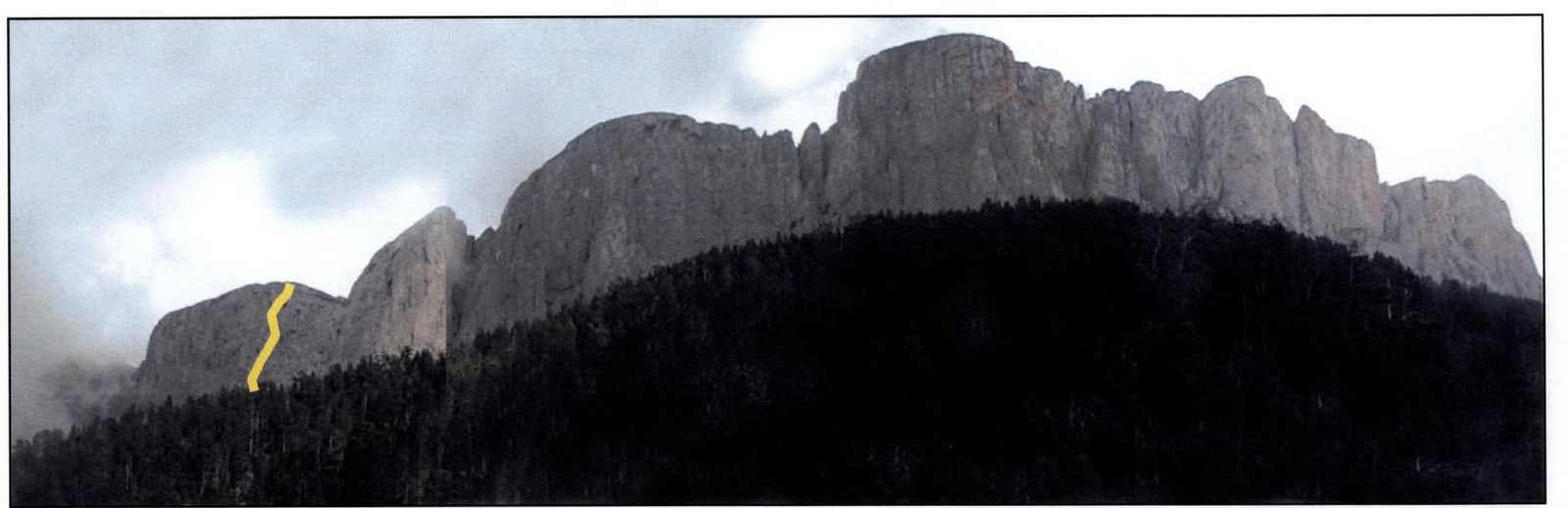
photo date: August 25, 2002
Bolshoi Tkhach Mt. (2368.4) in Krasnodar Krai is known to many from both tourist and speleological perspectives. However, it is undeservedly forgotten in alpinism. What a pity.
The 12 km long wall with a height difference of 100 to 300 m is visible from afar. The idea of alpine exploration of Bolshoi Tkhach has been around for a long time, but it only took shape this year.
On August 23, 2002, a team of Krasnodar climbers completed the first ascent of the counterfort of the SW wall via the "Novy God" route, approximately 3B category. With this route, we aim to start the exploration of Tkhach. Each route will be given its own name because almost the entire wall has a southwest orientation, and without identifying individual routes, descriptions could become confusing.
The wall's terrain is diverse, interesting, and quite complex. Simple routes can be found, but there won't be many. Here's Bolshoi Tkhach's calling card:
- Vertical chimneys
- Chimneys
- Cornices
- "Mirrors"
Free climbing is interspersed with ITO.
This area is not limited to Bolshoi Tkhach alone. Chertovy Vorota, Slesarnya Mt. are also waiting for their climbers. With the enthusiasm of climbers and support from officials in the "Bolshoi Tkhach" natural park, a serious rock climbing training ground can be established.
We hope that the positive decision on the classification of the "Novy God" route will give impetus to the exploration of Krasnodar Krai mountains and, consequently, to the greater popularization of alpinism in Southern Russia.
P.S. Please inform us about your decision regarding the route classification at eugvas@domostroy.com.
Sincerely, Vasenev Evgeny. 350011, Krasnodar, Stasova St. 182-88
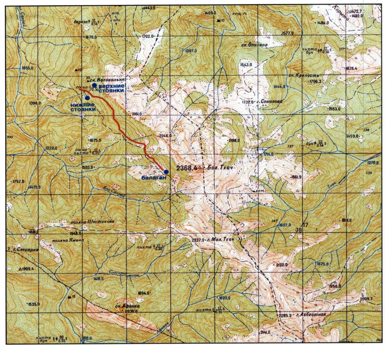
Area Map
Brief Geographic and Sporting Characteristics of the Climbing Object. Approach to Campsites.
Bolshoi Tkhach Mt. (2368.4 m) is located in the "Bolshoi Tkhach" natural park. This picturesque massif is situated on the border between the Republic of Adygea and Mostovskoy district of Krasnodar Krai. Its characteristic silhouette, formed by asymmetrical peaks (gentle to the north and steep to the south) of Bolshoi and Maly Tkhach mountains, is visible from many settlements and ridges of the Western Caucasus.
The main orographic element of the area is the Front Range, within which the described section is located. The following peaks stand out (from north to south):
- Kazachiy Piket (1184 m)
- Bolshoi Tkhach (2368.4 m)
- Maly Tkhach (2238 m)
- Asbestnaya (2285 m)
- Acheshbok (2486 m)
To the east of Acheshbok, the Agige (2311 m) and Sunduki (2200 m) ridges branch off. Bolshoi and Maly Tkhach are known to locals as Bolshaya and Malaya Lysaya mountains; not everyone is familiar with the geographical toponym. The massif is bounded to the west by the Sakhray river basin (a tributary of the Belaya river) and to the east by the Khodz river basin (a left tributary of the Laba river). The height difference between the summit of Bolshoi Tkhach and the surrounding riverbeds is approximately 1 km.
The average annual air temperature at the nearby Kisha weather station (1500 m above sea level) is +6.9°C, with annual precipitation of 854 mm. Snow falls in November-December, and a continuous snow cover lasts until mid-April (Agroclimatic Handbook, 1961). The vegetation cover consists of fir forests, which are replaced by high-mountain maple, birch, and aspen at higher elevations, and by meadows at around 1600 m, some of which are significantly degraded due to livestock grazing. Many meadow areas are clearly defined by the terrain and have their own names: Kunskie, Baronovy, Knyazheskie, Firsova, Sokolova. The wildlife is diverse (although significantly impacted by summer grazing and chronic poaching by shepherds), with large animals including:
- bison
- deer
- chamois
- roe deer
- wild boars
- bears
- wolves
In recent years, the wolf population has been growing, which may lead to situations worthy of Jack London's pen in winter treks (as evidenced by a couple of inscriptions on the walls of a shepherd's wagon at Sokolovy poliany).
The local population is primarily engaged in livestock breeding and logging, but recreational activities were once developed, and there was a hostel on Kunskie poliany serving a horseback riding route from the "Romantika" tourist base.
The wall section of Bolshoi Tkhach is 10-12 km long with a height difference of 100 to 300 m. The wall structure includes:
- destroyed rocks with grass
- sheer walls
- "mirrors"
There are fairly logical chimneys. "Mirrors" often have cornices of varying sizes.
The area is interesting for:
- rock climbing of relatively short length (from 3 to 10 ropes)
- bouldering - with a qualitative approach to route preparation and belaying
Area drawbacks:
- significant remoteness
- lengthy approach
- not very long route lengths.
On not very steep sections, belaying is challenging due to the lack of chimneys ("ram's foreheads") and destroyed rock. As the steepness of the sections increases, the wall's monolithic nature improves, and good placements for protection appear. Belaying on "mirrors" can also be challenging.
The most convenient path to Tkhach starts from the Novoprohladny settlement. Tourists and locals call it Sakhray. Do not confuse it with Ust-Sakhray, a settlement about 15 km from Novoprohladny. The road to Novoprohladny passes through Dakhovskaya. The main road goes to Guzeripl, and the required road turns left. There is a road sign. Almost immediately after Dakhovskaya, the road changes from asphalt to a good dirt road, which a loaded car can navigate without significant problems. If traveling by public transport, a bus leaves from Maikop around 4:00 PM to Novoprohladny.
The area is also accessible from another direction: by bus on the Labinsk-Mostovskoy-Uzlovoy route, and then by logging trucks or on foot. This option is currently less preferable due to the strict checkpoint regime in the mountainous part of Mostovskoy district.
The road to Tkhach begins at the end of the settlement. After crossing the river by bridge, one needs to move right along the road. The road leading left leads to Ust-Sakhray after 12 km. On the return trip, it's easy to get lost and take this road. A landmark on the return is a "Protect the forest" sign. As soon as you see it, turn left immediately - there will be a bridge.
By the way, there is a logging farm in Novoprohladny, meaning that cargo trucks regularly travel to the Tkhach area and can drop you off at Taiwan. Taiwan is the confluence of the Maly and Bolshoi Sakhray rivers. It's where you need to turn off the main road. However, let's return to the start of the journey. The road after the settlement is in much worse condition than before it. Here, you can travel either by cargo trucks or by UAZ. Walking takes 2 to 3 hours.
The road to Taiwan is straightforward and well-traveled. Sometimes it runs directly along the riverbed. There are fords and detours along the bank. At one point, there is a fairly distinct fork (on the return trip, it's no longer distinct and doesn't pose a "danger"). You need to go left and down. The correct direction is indicated by a gazebo on the right and a cairn.
Taiwan can be identified by a significant widening of the road. More accurately, not the road, but the space to the right. Here, you need to turn right, ford the river, and continue straight along the overgrown forest road. There's another road to the right and up, but it's not needed.
About 15 minutes later, on the right, you'll see:
- a gazebo
- a sign "Natural Park 'Bolshoi Tkhach'"
The road runs along the river and eventually ends. Then, you need to continue simply along the riverbed where it's convenient. After 50-60 minutes of normal walking, look for a left turn upwards. The landmark is a small cairn, but there's no certainty it will remain, as a flood could wash it away. The turn mentioned above is a marked trail leading to Bolshoi Tkhach. The trail is trodden and well-marked. At one point, when exiting a small clearing, there's a fork. You should go left and up. The trail down and to the right also seems correct (it makes a detour and returns to the main path), but there's no certainty. The entire journey along the marked trail takes about 3-4 hours.
There are several campsites under the wall. The first ones are lower (names are not universally agreed upon). The path to them lies:
- along an abandoned logging road (the marked trail continues straight, while the road turns right)
- then through a clearing and a stream into the forest
Alternatively, continuing along the trail upwards, near a tree with a mark, there's a turn to the right (there's also a spot for one tent and a fire pit). You need to follow this trail, cross a stream, traverse a clearing, and enter the forest a bit. There will be:
- a spot for 3-4 tents
- a fire pit
- a canopy
The second campsites are actually under Tkhach's wall. The marked trail eventually leads to a clearing from which the leftmost part of the wall is visible. The trail turns right towards the Vetryany balagan (this balagan is the third campsite, a 2-hour walk from the turn). You need to cross the clearing along its left edge, and there will be the campsites. To the left stands the Kolokolnya rock. In our opinion, the lower campsites are the best. Unlike the upper ones, they are closest to water. If routes are planned for the right part of the wall, it makes sense to head out in the evening and spend the night at Vetryany balagan. There is:
- a stove
- tents
Water and firewood are relatively nearby. It's advisable to bring polyethylene because there are holes in the roof. From the balagan, there's a panorama of the middle part of Bolshoi Tkhach's wall (the most suitable for climbing).
Material on the geographic description of the area is taken from the source "Caves of the Tkhach Massif", http://www.tourist.kuban.net/speleo/krok/8.html↗ Description of the alpinist part, approaches, and campsites - Vasenev Evgeny
Approach Description
From the lower campsites:
- Follow the trail to the marked trail
- Along it, first up, then right to the intersection with a stream
- Up the stream to under the wall
Landmark - a gap in the wall. From the campsites, 1 hour 40 minutes.
From the upper campsites. Descend to the marked trail and along it to the left to the intersection with a stream. Up the stream to under the wall. From the campsites, 1 hour 30 minutes.
From Vetryany balagan. Along the marked trail to the left (if standing facing the balagan) to the intersection with a stream. Up the stream to under the wall. From the balagan, 40-50 minutes.
Route Diagram in UIAA Symbols
Route Description
The counterfort begins with sheer wall sections. Bypass these sections to the right and ascend along them, roughly to where the pines end. The beginning of the route is marked.
Climb a short wall to reach the counterfort's ridge and follow it to a steep rock rise. Bypass it on the left via a destroyed inner corner. Station on a tree (R1). The ridge rocks are destroyed - move carefully! Then, via a small wall to the left of the tree, reach the ridge and continue on simple ridge rocks to a wall. Ascend the wall upwards to the right, around a bend. Climbing is careful - many loose rocks. Station on a tree (R2). This tree is not visible from the ridge. From here, ascend to the ridge and along it to the next wall, with a station on a tree (R3). At this point, be attentive as a convenient ledge appears to a simple gully on the left, but you need to continue straight up the wall. The landmark is a large rock protruding from the wall. Ascend through it upwards to a small ledge, where there's a station (R4). The wall is quite steep but contains many loose rocks. A bolt piton is driven at the station. From the ledge, make a short traverse to the right and ascend via simple rocks to a ledge with a tree, where there's a station (R5). This tree is not visible from the previous station. On the ledge, a control cairn (k/t) is built. The next rope length is key. From the tree, ascend upwards to the right along a monolithic wall section into an inner corner (not visible from the station). Ascend the corner, which is unpleasant due to dripping water, and then exit upwards via simple rocks to the alpine section. Descend left (standing with your back to the wall) along the alpine section to a descent gully in the left part of the wall. Near the gully, a tour is built. Landmark: continue until you're level with the "Kolokolnya" rock. Warning: in fog, it's easy to get lost and descend too far.
General Conclusion on the Route
The completed route along the counterfort of the SW wall of Bolshoi Tkhach Mt. is an interesting rock climbing route. It is logical and safe. Almost all stations are located on pine trunks (which is why it's called "Novy God" - the team gathered at the base resembles a round dance around a Christmas tree).
The route will be significantly complicated during rain or fog, especially on the key section, as it's somewhat damp even in good weather.
When evaluating the route, the team compared it to the following previously climbed routes:
- 3B category route
- 4A category route
- Belalakaya via S ridge - 3A category
- Belalakaya from the north - 3B category
- Dombay Main - 3B category
- Pik Ine via NW ridge - 4A category
The team believes that the complexity of the climbed route is not inferior to previously climbed 3B category routes. However, due to its shorter duration, it's less challenging than a 4A category route.
The route can be recommended as an interesting rock climbing route for sports ascents.
Based on the above, the team considers that the route along the SW wall of Bolshoi Tkhach Mt. can be assessed as a 3B category route.
Team leader: Grishchenko Natalia
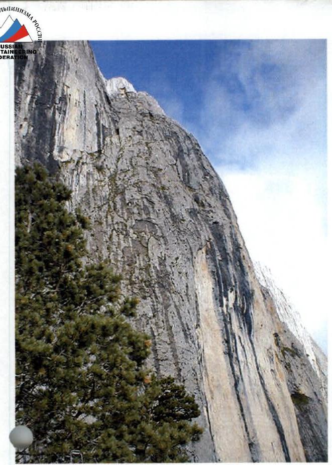
Route Photos. General View.
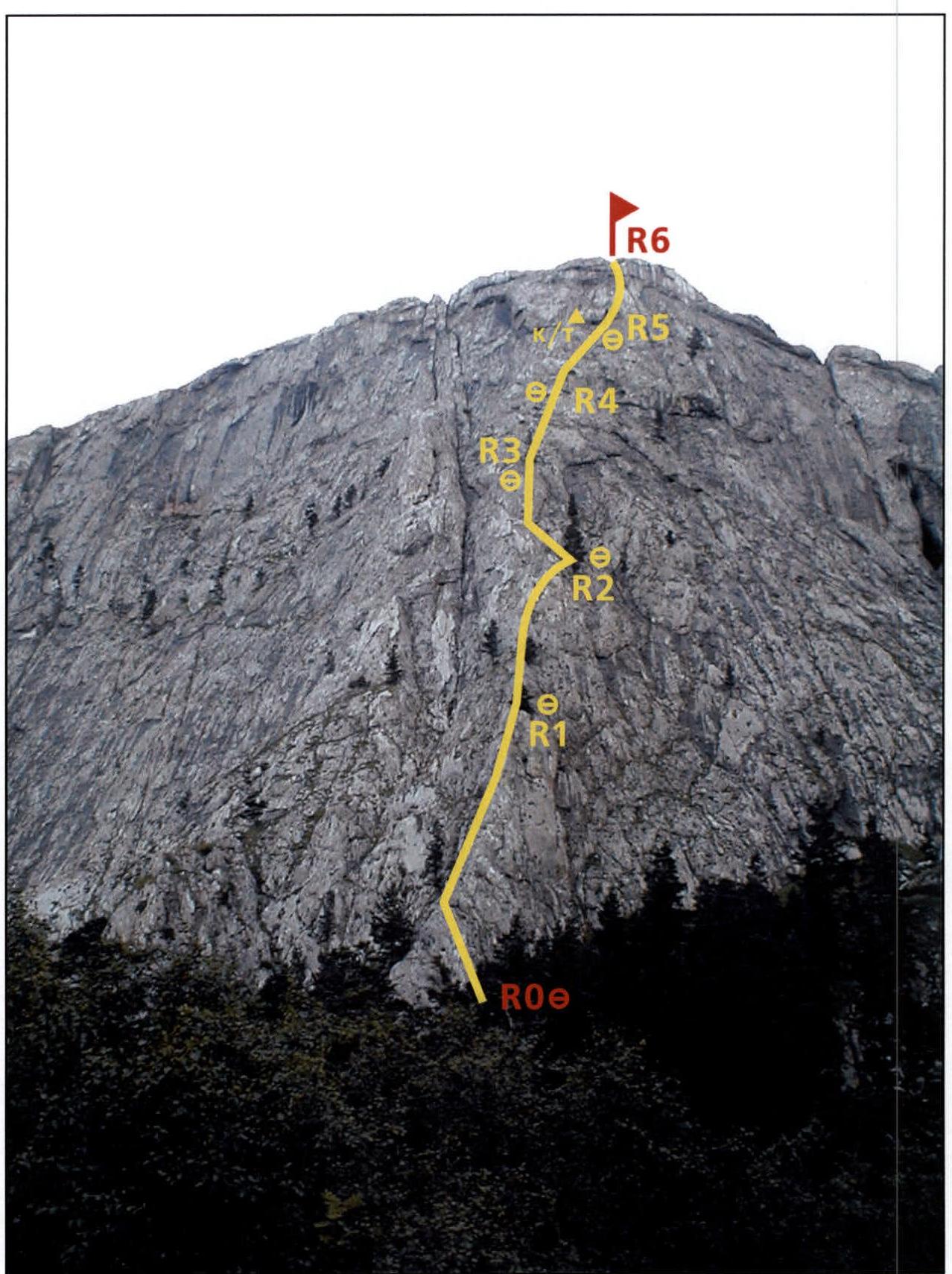
photo date: August 22, 2002
Route Photos. R0-R1 Section.
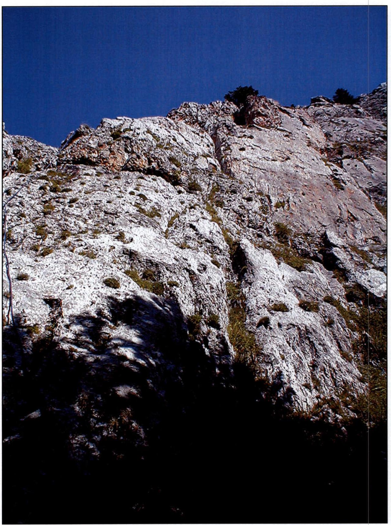
photo date: August 23, 2002
Route Photos. R4-R5 Section.
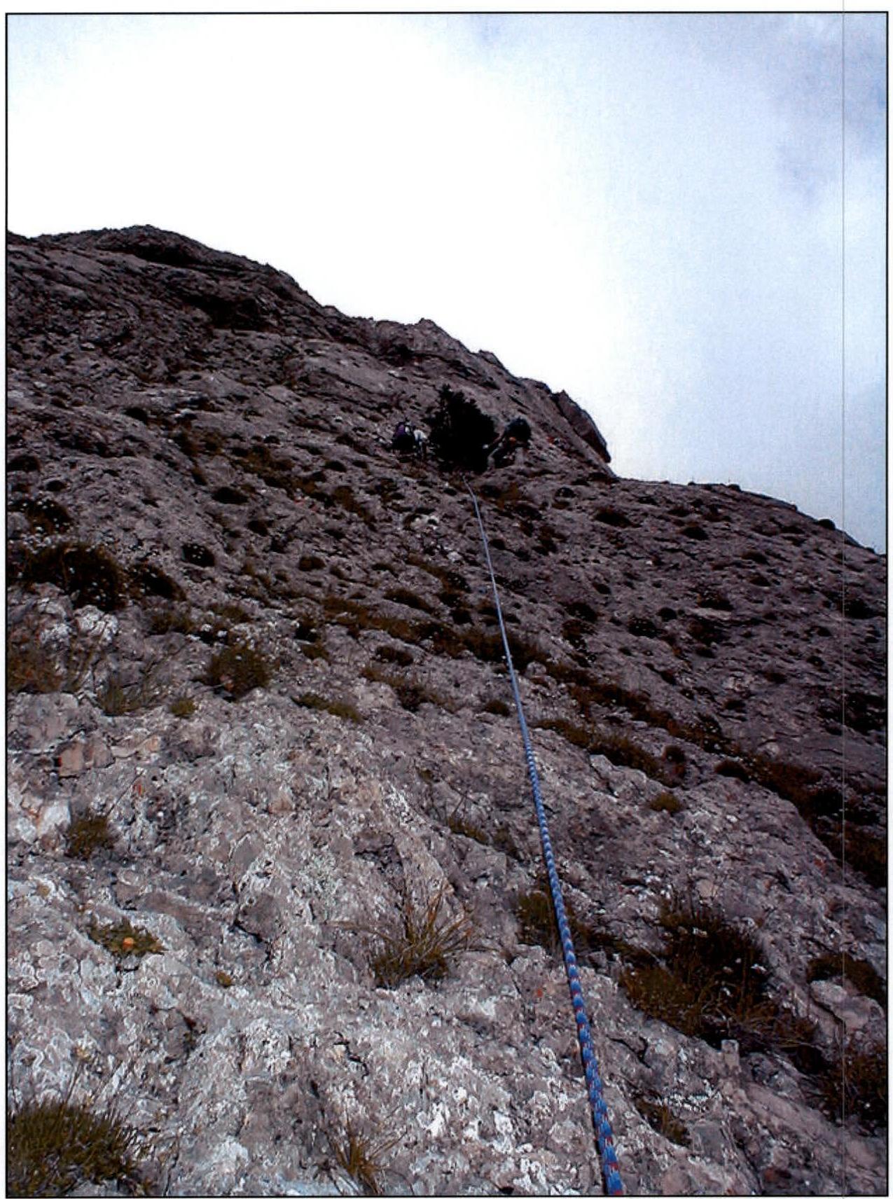
photo date: August 23, 2002
Route Photos. R5-R6 Section.

photo date: August 23, 2002