


Fig. 35. North-west buttress, ridge and summit point of the peak Pyatigorsk with the ascent route (13). Photo by A. Runich.

Fig. 37. The summit 1300 years of Bulgaria with its traverse route. Photo by A. Makushenko.

Fig. 38. The summit Ak-Airy with its traverse route. Photo by A. Makushenko.

Fig. 39. Sketch of the traverse of the Ak-Airy horseshoe. Part of the traverse from the beginning of the route to the saddle between the summits Pyatigorsk and 1300 years of Bulgaria (East Ak-Airy pass). Scale 1:5000. In the inset photos: a — view of the Ak-Airy horseshoe. Photo by B. Fedorov; b — on the dome of the Ak-Airy summit. Photo by A. Makushenko.
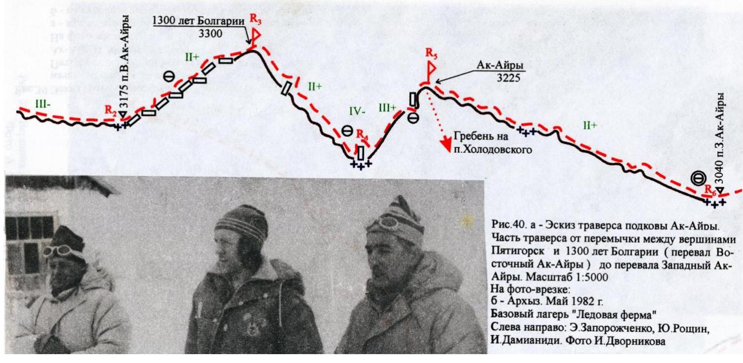
Fig. 40. a — Sketch of the traverse of the Ak-Airy horseshoe. Part of the traverse from the saddle between the summits Pyatigorsk and 1300 years of Bulgaria (East Ak-Airy pass) to the West Ak-Airy pass. Scale 1:5000. In the inset photo: b — Arkhyz. May 1982. Base camp "Ice Farm". From left to right: E. Zaporozhchenko, Yu. Roshchin, I. Damianidi. Photo by I. Dvornikov.

Fig. 41. Sketch of the traverse of the Ak-Airy horseshoe. Part of the traverse from the West Ak-Airy pass to the end of the route. Scale 1:5000. In the inset photo, the summit Nadezhda (photo from 1978 by B. Fedorov).
Pyatigorsk–Nadezhda
The Ak-Airy glacier is dominated by a horseshoe-shaped rocky ridge, which is the central part of the extended Sofiyskiy ridge — the main orographic dominant of the area. The key summits of this ridge are Pyatigorsk to the east and Nadezhda to the northwest. The ridge also features two other summits and two depressions, through which one can pass to the upper reaches of the Kyzygych River (East Ak-Airy pass) and the Pshysh River (West Ak-Airy pass). These summits (unnamed) are marked on the state topographic map at a scale of 1:25000 and have absolute elevations of 3301 and 3229.6 m, respectively (according to the altimeter readings of the first ascenders — 3300 and 3225 m).
The route through all four ridge summits is classified according to the "Report on the first traverse of the Pyatigorsk–Nadezhda summits (Ak-Airy horseshoe) with two first ascents to the summits 1300 years of Bulgaria and Ak-Airy from east to west," submitted to the classification commission of the Alpinism Federation of Stavropol Krai in 1981. The name of the Ak-Airy summit is local. The complete traverse was performed as part of a Stavropol sports committee event dedicated to the 1300th anniversary of the Bulgarian state. Hence, the name given to the second summit on the traverse.
- Traverse of the Pyatigorsk–Nadezhda summits, category 3A. September 20, 1981. E. Zaporozhchenko, I. Belokurov, I. Gavrilov, N. Duplenko, I. Sokolenko, A. Makushenko, V. Golikov, I. Shaposhnikova.
The ascent path to the summit Pyatigorsk is described in route 13; the descent path from the summit Nadezhda is described in route 14. Below are brief descriptions of the initial and final parts of the traverse, which are interesting due to features identified by repeated ascents.
Route 15 (Fig. 39). The path to the start of the route along the Northwest buttress of the Pyatigorsk summit goes along the terminal moraine ridges of the Northwest Sofiyskiy glacier, exiting to its northwest extremity and then along the glacier to the start of route 13. From the bivouac, 1–5 hours. Absolute elevation — 2810 m.
Start of the route. Section R0–R1 (Fig. 36a):
- On snow covering the glacier, initially gentle, transitioning into a snow "tie" with a steepness of up to 35–40° indenting into the buttress
- To the talus shoulder under the central part of the buttress
- Insurance through an ice axe
- Movement in rope teams
- Absolute elevation — 2995 m
There are no open crevasses on the glacier. The covering snow is dense.
Section R1–R2. Up the mobile talus directly towards the "gate" between two gendarmes with a small snow patch at the base of the left one. Up a wet chimney ~4 m to a ledge (hook for insurance). Then along the steep talus slope to the base of a couloir with individual snow patches.
Absolute elevation — 3090 m.
Section R2–R3. Along the couloir, adhering to the rocks on the right side (alternate insurance through ledges), to the first narrowing with inclined slabs and a ledge — a wall, 4 m high (hook). From here, the couloir turns left, and after 30 m, there is a wide ledge to the left of it, where 1–2 tents can be placed, and where a control cairn is installed. Absolute elevation — 3170 m. A wonderful view of the Pshysh River valley!
Section R3–R4. Along the left side of the gradually widening couloir — exit to the Northwest ridge leading from the buttress to the summit peak. There are sufficient ledges for insurance. Absolute elevation — 3260 m.
Section R4–R5. Represents a ridge of northwest exposure with a series of gendarmes. Besides the summit tower, three gendarmes are most pronounced.
From point R4, after 30 m, ascent "en face" to the 1st gendarme. Descent from it along the ridge to a rocky saddle, to the right of which are talus ledges. Along the ledges on the right side of the ridge, with a gradual gain in height, overcoming short walls, the second and third gendarmes are bypassed. Insurance — through ledges.
For the separation of the second stage of training, the installation of ropes is required on certain sections.
After the third gendarme — exit to the narrow western crest of this gendarme, limited on the right (in the direction of travel) by a cleft leading to the main ridge. To the left, along the crest, with hook insurance and insurance through ledges (40 m) — exit to the main ridge.
Here, movement goes along the left side of the ridge to the base of the stepped summit tower. Absolute elevation — 3310 m.
The tower is ascended in a direction from left to upwards, exiting to its sharp summit part.
From the start of the route (point R0) — 4 hours.
The summit tower is composed of grey granite-porphyry.
Section R5–R6. Along the Eastern, heavily destroyed, steep ridge to the Kozhukhov pass (Sofiyskiy). Absolute elevation — 3290 m. When descending, utmost care is required. Movement is alternate. Insurance is through ledges, previously thoroughly tested, or with hook insurance.
Further down the glacier. The glacier:
- is initially steep, with numerous crevasses and a serious bergschrund (ice screws are necessary);
- then becomes more gentle;
- becomes steeper again towards the tongue.
To the "Spartakovskie" overnight stays — 1.2–2 hours.
Recommendations for Climbers
Despite the fact that the first ascenders, among whom were "Snow Leopard of the USSR" S. Chuenko and Honored Master of Sports of the USSR I. Damianidi, assessed the route as fully corresponding to category 2A, it was classified by Moscow as lower, as is often the case. This should be taken into account and not planned as a qualifying ascent for novice climbers.
When descending from the pass to the glacier, in the upper and lower parts of the glacier at the end of summer, the following will be required (for insurance purposes):
- 3–4 ice screws;
- a pair of crampons for the last person descending.
It is advisable to have shorter main ropes, 20–30 m; 4–5 rock screws (or chocks) are sufficient.
Comments
Sign in to leave a comment