Ascent Passport
- Region, gorge, section number according to KMGV-2001 — Western Caucasus, Belaya River gorge, section 2, subsection 2.1. Krasnodar and Stavropol regions up to Marukh pass.
- Name of the peak, its height, route name — Mt. Oshen (2804 m) via the northeastern counterfort and northern slope.
- Route character — combined.
- Assumed 1Bz category of difficulty, first ascent.
- Route height difference — 426 m. Route length — 900 m. Length of sections: V category of difficulty — 0 m, VI category of difficulty — 0 m. Average steepness: main part of the route — 30°. entire route — 25°.
- "Hooks" left on the route: total — 0; including pitons — 0. Total used on the route: rock anchors — 0, chocks, etc. — 0. Pitons used: stationary pitons — 0, including ITO — 0, removable pitons — 0, including ITO — 0.
- Team's travel hours — 6.5 hours, 0.4 days.
- Leader: Khrabovchenko Vladimir — 2nd sports category. Participants: Eliseev Alexander — 1st sports category. Makarenko Timofey — 2nd sports category.
- Coach: Kravchenko Oleg Viktorovich — Candidate Master of Sports, 2nd category instructor.
- Departure for the route — 8:30 AM, December 13, 2003. Reaching the summit — 1:30 PM, December 13, 2003. Return to the base camp — 3:00 PM, December 13, 2003.
- Organization — Krasnodar Regional Public Organization "Mountain Club 'Extrem'".
Technical photograph with the route marked and divided into sections

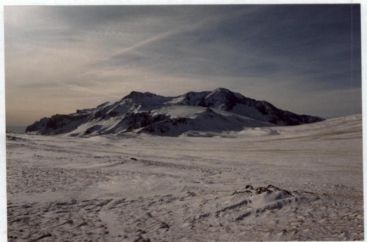
Photograph of the peak's general view from Abadzekhsky pass
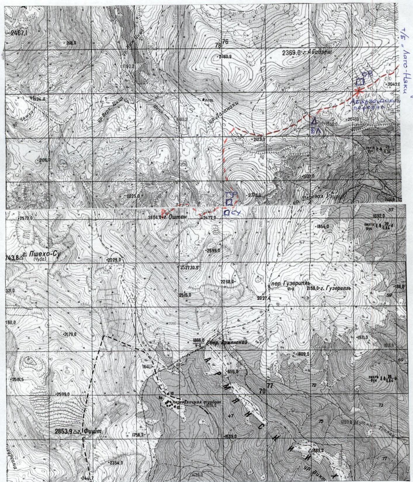
Map of the ascent area

Brief Overview of the Area. Description of the Approach to the Peak and Ascent Route
Geographical Location
Mt. Oshen is part of the Fisht-Oshen massif, located on the Lago-Naki highland. This is a part of the Western Caucasus mountains between the Belaya and Pshekha rivers. Administratively, it is situated in the Maykopsky district of the Republic of Adygea.
History of Alpine Exploration
One of the first ascents to the peaks of Fisht and Oshen was made by the Russian botanist N.M. Albov, who mentioned it in his 1894 publication. In 1888, the naturalist N.I. Kuznetsov ascended Oshen as part of geobotanical observations for the Russian Geographical Society. These ascents were made via the most accessible route — the southern slope of the mountain. By 1958, the first winter ski traverse from Guzeripl settlement to the Fisht-Oshen massif was completed (led by V.V. Litvinov). The area is known for its favorable conditions for mountaineering:
- easy transport accessibility,
- safe crime situation,
- no need for tourist formalities,
- developed tourist infrastructure.
Orography and Relief
The Lago-Naki highland is a combination of:
- mountain ridges,
- high-altitude massifs,
- small plateaus bordered by steep rocky walls to the west, east (Khrebet Kamennoye More ridge), and south (southern walls of Fisht and Psheha-Su).
The highland gently slopes to the north and is at the junction of natural boundaries (geological, geomorphological, climatic, etc.). The massif of Fisht, Psheha-Su (2743 m), and Oshen (2804 m) crowns the highland to the south, rising nearly a thousand meters above the nearby western peaks of the Main Caucasian Range (MCR).
On a clear day, Fisht can be seen from Maykop, Sochi, and even Krasnodar, which is 135 km away in a straight line. Fisht, Oshen, and Psheha-Su form a horseshoe-shaped cirque around the upper reaches of the Belaya River, with the Fishtinsky refuge located on its flat bottom.
The Fisht massif is separated from the rest of the highland by a wide intermontane depression located in the upper reaches of the Tsitse River.
To the north lies the Nagoy-Chuk massif (2467 m), and to the east, the Abadzekh-Murzilkao massif (2360 m).
Weather Conditions and Snow Cover
The area's natural conditions are unique and diverse, characterized by rapid changes and unpredictability within a day or even hours. This is due to the terrain features and the proximity of the Black Sea. The massif's sharp rise leads to the interception of moisture-laden air masses from the south and west. Therefore, the total precipitation decreases from south to north and from west to east. The highest precipitation occurs around Fisht and Oshen, approximately 3500 mm per year. The average July temperature is +18 °C, and January is -2 °C. The average annual precipitation ranges from 1600 to 3200 mm. The intra-annual distribution of precipitation is relatively uniform. The maximum precipitation in the Oshen area occurs in December. The prevailing wind direction in July and January is south. Local winds, such as mountain-valley and glacier winds, are developed. The average maximum snow cover height ranges from 100 cm in the north and west to 300 cm in the south and southeast. Snow cover at about 2000 m appears in mid-October and becomes stable by early November. The maximum snow depth recorded in the Fisht group was 610 cm. Snowmelt is prolonged. Thus, the area's snow conditions fit within the duration of winter routes in the Western Caucasus. The average frost-free period is up to 150 days. The area is known for heavy snowfalls and snowstorms possible in summer and during the off-season, especially in autumn.
Description of the Approach to the Peak and Ascent Route
From the "Lagonaki" tourist base, follow the road and then a marked trail to Abadzekhsky pass (4 hours).
From the pass, descend to the Lagonaki tract near the source of the Armanka River. This is where the base camp is set up (1 hour from the pass). The most convenient spot is in a snowdrift in a gully of one of the tributaries. Camping in open areas is not recommended due to strong winds.
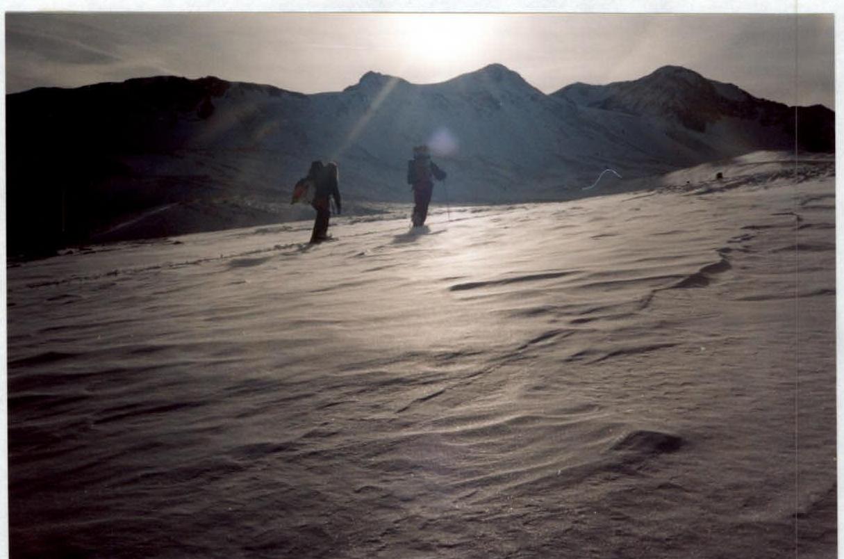
The approach to the route from the camp is in the direction of the Tsitse and Armanka rivers' watershed (southwest) towards the pronounced northeastern shoulder of the mountain. Then, along the shoulder, move south towards the "ram's foreheads" of the rocky outcrop at the base of the northeastern counterfort. The approach from the camp takes about 1 hour.
Route Description
Route scheme in UIAA symbols
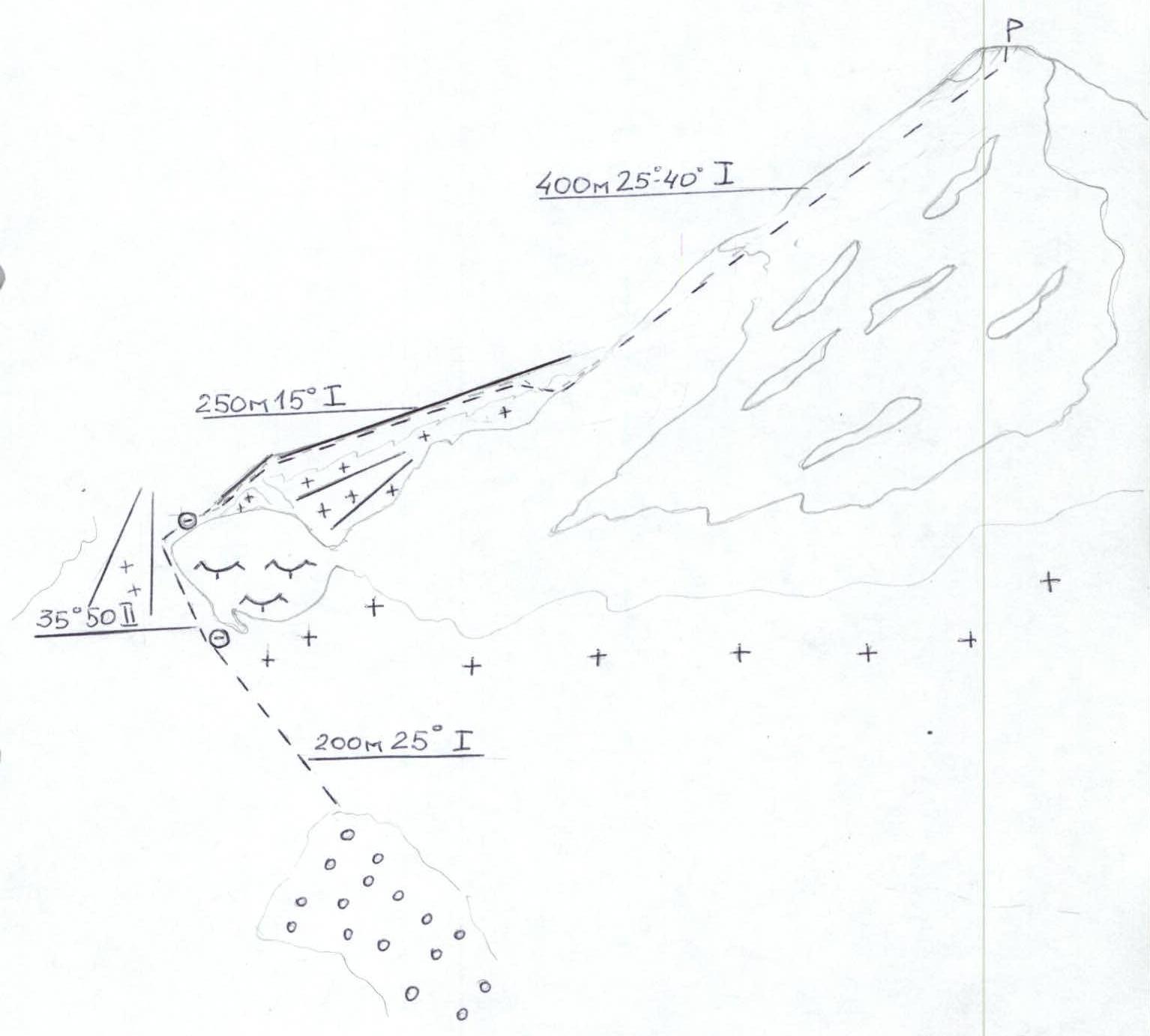
Brief Description of the Route
Start with a simple snow ascent (25°, 200 m, category I difficulty) to the base of the rocky outcrop at the foot of the northeastern counterfort. Bypass the outcrop on the left through the snow (35–40°, 50 m, category II difficulty) with alternating belay (or rope protection). To avoid undercutting the slope and potential avalanches, stay closer to the rocks. Then, ascend to the debris-covered ridge of the northeastern counterfort and move simultaneously towards the snow saddle between the counterfort and the northern slope of the eastern ridge (15°, 250 m, category I difficulty). Before reaching the saddle, veer right, cross a snow couloir, and ascend to the northern slope of the peak. Climb the peak via debris-covered ledges and broken rocks on the slope (25–40°, 400 m, category I difficulty) to reach the summit (1.5–2 hours from the counterfort). Descend via the ascent route.
Safety Assessment Recommendations
The main hazards on the route are potential snow avalanches from the northern slopes of the eastern ridge and rockfall on the northern slope. Although information about these phenomena was not found during the initial research, and they were not observed, avalanches can be triggered by snow metamorphism and the collapse of snow cornices from the eastern ridge.
Therefore, before starting the route:
- Check the snow conditions.
- Organize movement with necessary safety precautions.
On the northern slope, move in a tight group, carefully. In winter, strong southern winds can cause loss of balance. Thus, maintain the rule of three points of contact.
The primary danger on the approach is getting lost on the way to Abadzekhsky pass in poor visibility (snowstorm, etc.). Therefore, check the weather forecast before heading out. After snow cover sets in, using skis for the approach is recommended.
Photographs of the most challenging section of the route
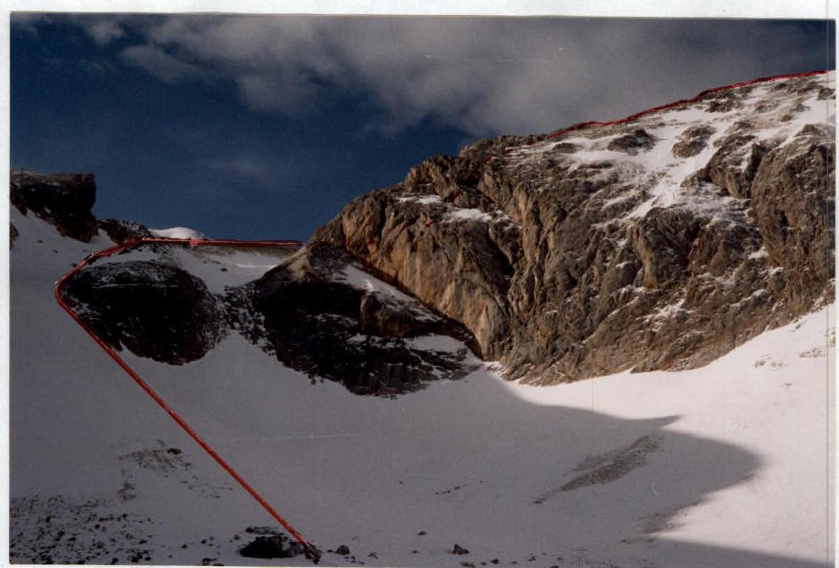
Bypassing the rocky outcrop at the base of the northeastern couloir
Recommendations for Subsequent Groups
The recommended equipment is typical for winter routes of this category of difficulty.
Individual Equipment:
- Vibram-soled boots
- Gaiters
- Ice axe
- Combined harness
- Gloves
- Crampons
- Goggles
- Prusik knot
Pay great attention to warm and windproof clothing and bivouac equipment. It's advisable to have a thermos with hot drinks for the approach and ascent.
Group Equipment:
- Main rope
- Snow shovel
- Avalanche probe
- Radio station
Cellular communication (GSM standard) is available from the summit and passes.
The route's specifics are determined by the general characteristics of winter ascents: a shortened daylight period, significant time and energy spent on bivouac arrangements, and weather variability. Due to strong winds and temperature differences on the counterfort slopes, the following can form:
- wind crust,
- hard firn,
- ice formation.
Therefore, participants should have crampons.
A characteristic sign of the route's start is the snow ascent from the relict moraine to the rocky outcrop at the base of the northeastern counterfort.
Conclusion on the Preliminary Assessment of the Route
In assessing the route's complexity, the group was guided by clause 3 of the Recommendations for the Classification of Ascent Routes, approved by the Board of the Russian Mountaineering Federation (protocol No. 8 of September 9, 2002), and experience with ascents of similar category and difficulty in similar natural conditions (height, relief, steepness, weather) in the Western Caucasus. Specifically, during the ascent debrief, participants noted that the route is not less challenging than the following routes previously completed by the group:
- Fisht via the northern slope — 1Bz category of difficulty;
- Fisht via the SE ridge — 2A category of difficulty;
- Kelbashi S ridge with Karadjaš pass — 1B category of difficulty;
The route is logical and safe as it primarily follows the counterfort. It allows novice mountaineers to practice snow and easy rock climbing techniques and belay organization. Thus, it is recommended for training ascents.
The route undertaken by the group is significant for training novice mountaineers. Firstly, the ascent area offers:
- Excellent opportunities for training on rocky and snowy terrain,
- Good transport accessibility,
- Developed tourist infrastructure,
- Cellular network coverage,
- Presence of EMERCOM forces.
This significantly simplifies and reduces the cost of organizing winter mountaineering expeditions and training sessions. At the same time, the climatic conditions of winter mid- and high-altitude areas impose serious demands on the preparation of novice climbers.
Secondly, the approach to the route includes crossing a pass above 2000 m, and the high-altitude hike allows for at least two nights in the high-altitude zone.
Group Leader, 2nd sports category, Ph.D. in Geography Khrabovchenko V.V.
Coach, Candidate Master of Sports, 2nd category instructor, certificate No. 388 Kravchenko O.V.
Senior Coach of "Extrem" Mountain Club, Candidate Master of Sports, 1st category instructor, certificate No. 27 Gorbachevsky A.D.
Chairman of the Classification Commission of the Krasnodar Regional Mountaineering Federation
Candidate Master of Sports, 1st category instructor, certificate No. 25

Krivov V.N.

Appendix
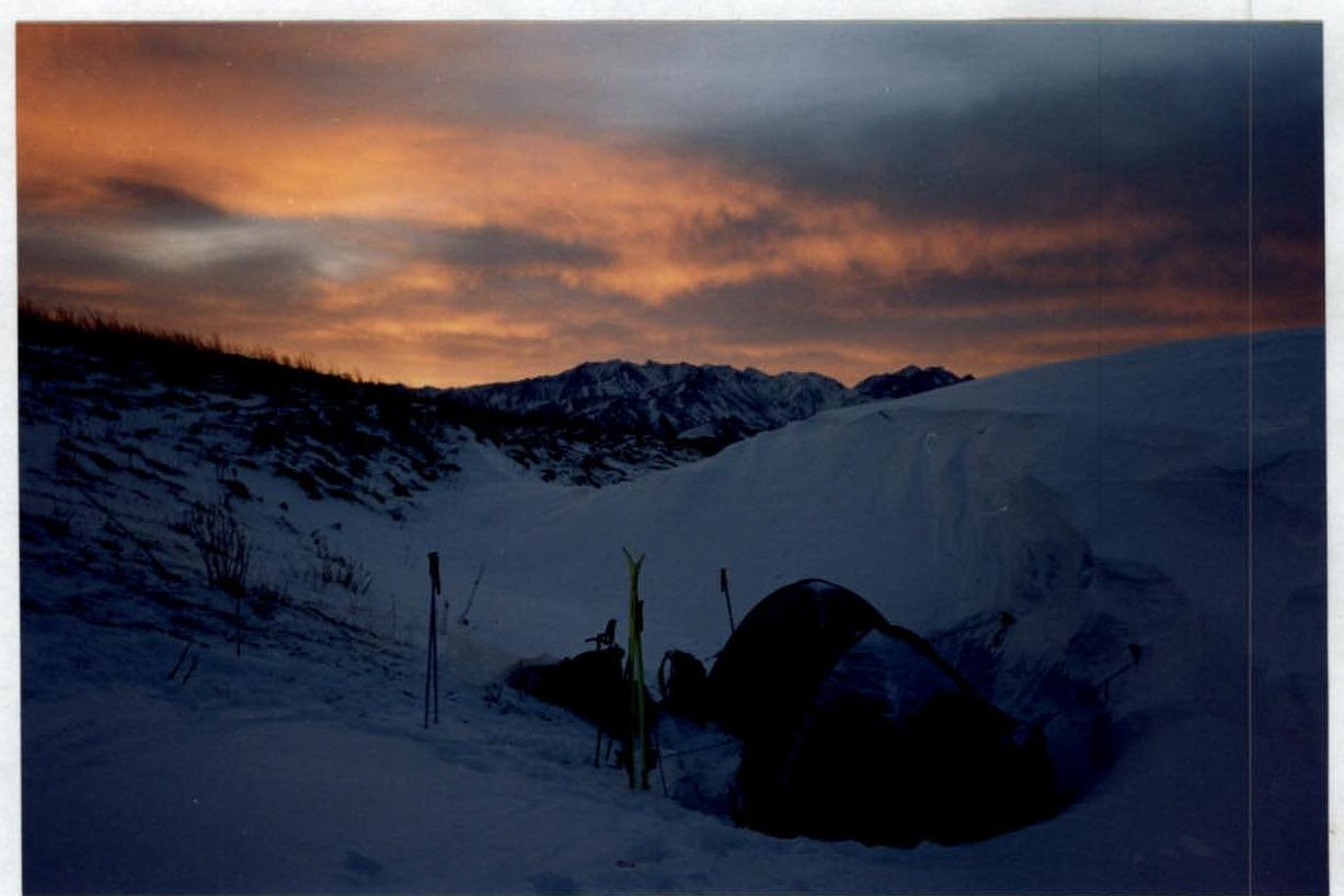
Photograph of the base camp location
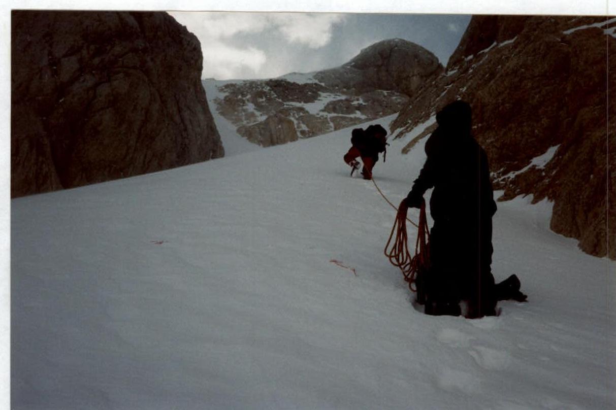
Photograph of the approach to the route