Ascent Passport
I. Ascent class - rock. 2. Ascent area - Western Caucasus. 3. Peak, its height, ascent route - Larb, 2998 m, via the northeast wall. 4. Proposed difficulty category - 5B. 5. Route characteristics:
height difference - 1000 m, length of sections with 5-6 cat. diff. - 395 m, average steepness - 65°
- Number of pitons driven for belaying and creating artificial holds:
rock - 135; ice - none; bolt - none.
- Number of climbing hours - 25 hours.
- Number of nights and their characteristics - two, comfortable.
- Surname, name, patronymic of the leader, participants, and their qualification:
- Pogosyan Fedor Lipparitovich, CMS, leader
- Khakh Bangur Cherimovich, CMS, participant
- Yakovlev Sergey Efimovich, CMS, participant
- Gorbachevsky Alexander Dmitrievich, 1st sports category, participant
- Krivov Vasily Nikolaevich, 1st sports category, participant
- Shutov Sergey Trofimovich, 1st sports category, participant.
Team coach: Master of Sports, Kisel Sergey Yakovlevich.
II. Date of departure and return: departure on May 3, return on May 5, 1977.
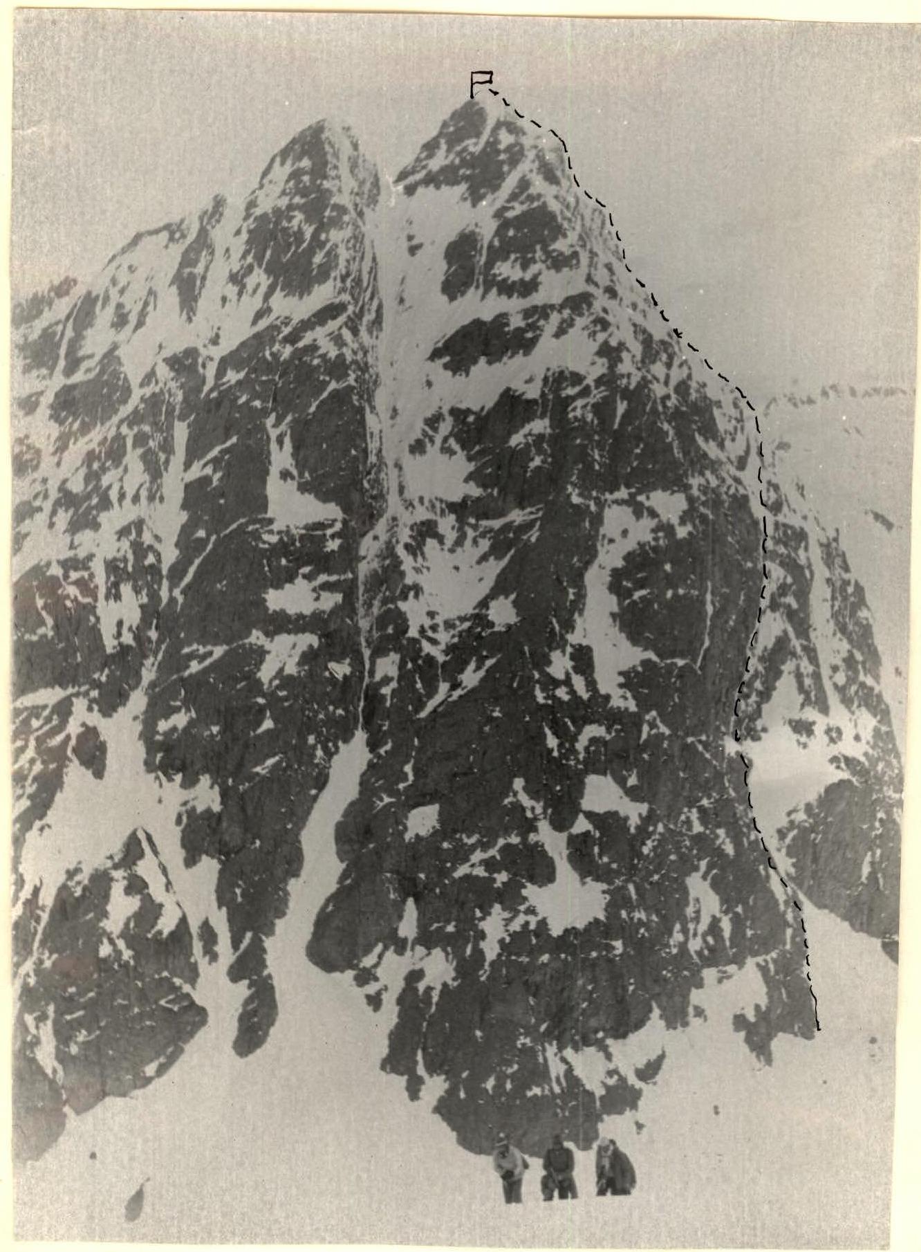
- Pogosyan F.L. group's route
| 1 | 2 | 3 | 4 | 5 | 6 | 7 | 8 | 9 | 10 | 11 | 12 | 13 | 14 | 15 |
|---|---|---|---|---|---|---|---|---|---|---|---|---|---|---|
| 3.05.1977 | R0–R1 | 35° | 300 | Snow slope | II | Fresh snow on top | Good | Belay with ice axe | Simultaneous movement | 6:00 | ||||
| R1–R2 | 60° | 120 | Couloir | IV | Snowy, icy | Good | 4, outcrops | Free climbing | ||||||
| R2–R3 | 65° | 170 | "Sheep's forehead" type rocks | IV | Snowy, icy | Good | 10 | Free climbing | ||||||
| R3–R4 | 60° | 70 | Inclined inner corner | IV | Snowy, icy | Good | 6 | Free climbing | ||||||
| R4–R5 | 60° | 60 | Inclined inner corner | V | Snowy, icy | Good | 9 | Free climbing | ||||||
| R5–R6 | 60° | 180 | Inclined inner corner | V | Snowy, icy | Good | 15 | Free climbing | ||||||
| R6–R7 | 70° | 30 | Wall | IV | Monolith | Good | 3, outcrops | Free climbing | ||||||
| R7–R8 | 90° | 20 | Wall | VI | Monolith | Good | 10 | 6, Free climbing | ||||||
| R8–R9 | 75° | 30 | Slabs | V | Monolith with ice | Good | 15 | 6, Free climbing | ||||||
| R9–R10 | 85° | 15 | Inner corner | V | Monolith | Good | 3 | Free climbing | ||||||
| 4.05.1977 | R10–R11 | 85° | 50 | Inner corner | VI | Monolith, water flowing | Satisfactory | 8 | 8, Free climbing | 17:00, 2 climbing hours. Comfortable bivouac. | ||||
| R11–R12 | 70° | 50 | Chimney, slabs, wall | V–VI | Monolith, snowy, icy | Satisfactory | 4 | 4, Free climbing | 7:00 | |||||
| 5.05.1977 | R12–R13 | 85° | 30 | Rocky ridge, slabs | IV | Snowy, icy | Satisfactory, snow started | 4 | Free climbing | 18:00, 2 climbing hours. Comfortable bivouac. | ||||
| R13–R14 | 60° | 50 | Rocky ridge | IV | Monolith | Satisfactory, fog, snow | 4 | Free climbing | ||||||
| R14–R15 | 50° | 40 | Snow "knife" | III | Snow | Poor, snow, fog | Belay with ice axe | Alternating movement | 8:00 | |||||
| R15–R16 | 50° | 170 | Rocky ridge | III | Snowy | Poor, fog | 5 | Free climbing | ||||||
| R16–R17 | 45° | 150 | Snow-rock ridge | III | Snowy rocks, snow | Poor, fog | 2, Belay with ice axe | Free climbing | ||||||
| R17–R18 | 50° | 60 | Snow-rock ridge | III | Snowy rocks, snow | Poor, fog | 3, Belay with ice axe | Free climbing | ||||||
| R18–R19 | 30° | 120 | Snow ridge | II | Poor, fog | Belay with ice axe | Simultaneous movement | |||||||
| R19–R20 | 50° | 60 | Rocks, snow slope | IV–III | Snowy | Poor, fog | 6, Belay with ice axe | Free climbing | 11:00, reached the summit. 3 climbing hours. | |||||
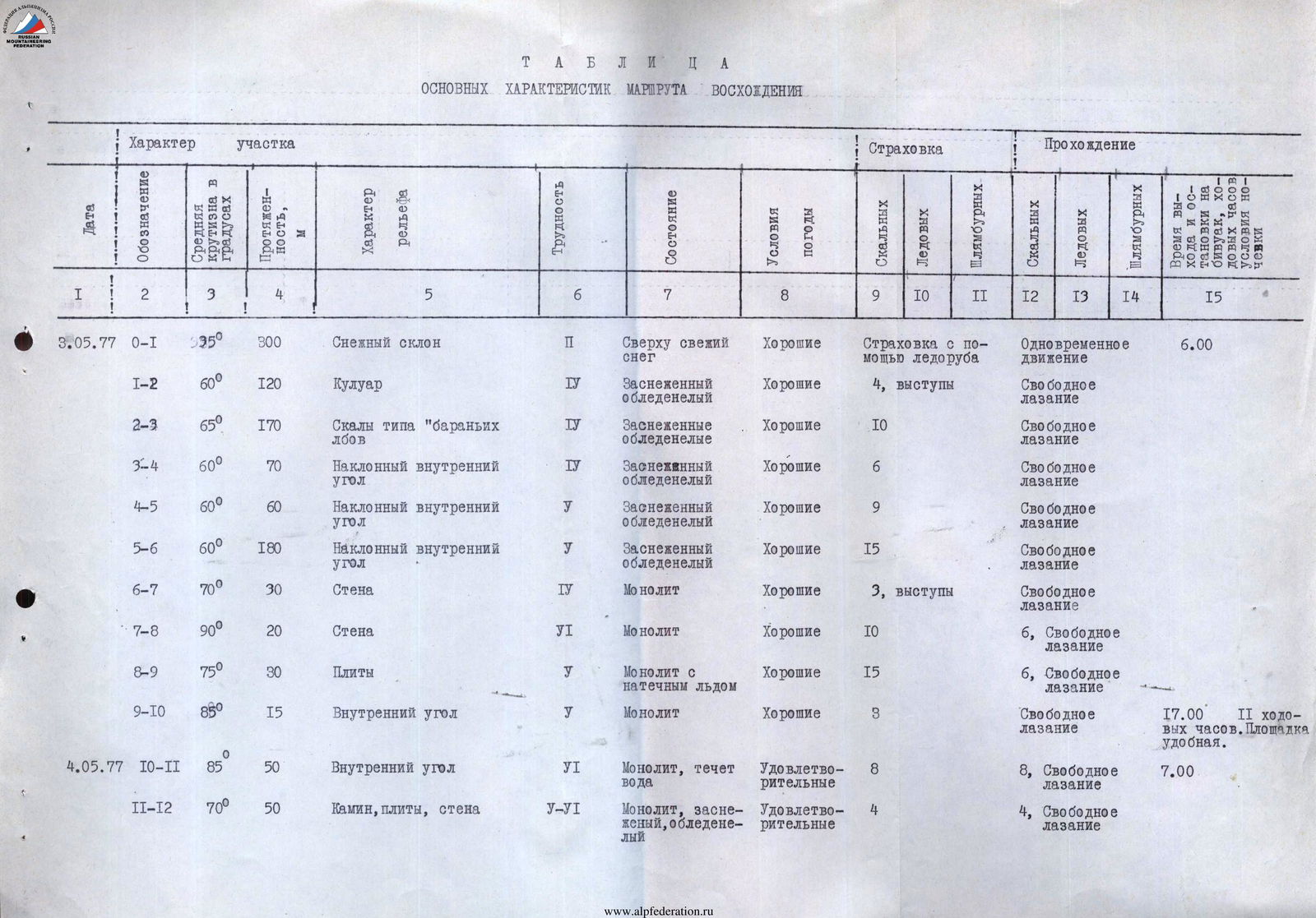 |
Table of main characteristics of the ascent route
Brief explanation of the table
Section R0–R1. Snow slope 300 m, simultaneous movement, belay with ice axe. Section R1–R2. Snow-ice couloir, piton belay. Section R2–R3. "Sheep's forehead" type rocks, snowy, partially icy, medium to difficult climbing, piton belay. Section R3–R4. Inclined inner corner, left side overhanging, right side icy and snowy, piton belay; corner ends with a snowy ridge. Section R4–R5. Inclined inner corner, snowy and icy, leads under a rocky overhang. Overhang is bypassed on the left, very difficult climbing, piton belay. Section R5–R6. Inclined inner corner, snow, partially ice, piton belay. Section R6–R7. Leaving slabs on the left, up rocks to a нависающий outcrop "forehead", piton belay. Section R7–R8. Rocks of the "forehead" that overhang, then steepness decreases to 80°, "forehead" is passed on artificial holds (ladders). Section R8–R9. After the "forehead" steep slabs and exit under a 12-meter overhang, difficult climbing, piton belay. Section R9–R10. Overhang is bypassed on the right via a destroyed inner corner and exit to a ledge under an overhanging wall, piton belay, backpacks are pulled through the overhang with a lower belay. Snowy ledge under the overhanging wall. Snow is cleared, a bivouac site is trampled. Bivouac, five in a tent, one next to the tent. Section R10–R11. Inner corner with an overhang, passed on artificial holds (ladder, platform), monolith, backpacks are pulled. Weather deteriorates, snow starts, water flows down the corner. Section R11–R12. Chimney, overhanging and icy, transition to slabs of the counterfort, outcrop under an overhang. Backpacks are pulled, section is passed on artificial holds (ladders). Section R12–R13. Ridge of the counterfort, snowy and icy slabs, exit to a snowy saddle, snow is unstable, belay is difficult. Section R13–R14. Rocky ridge with snow, good outcrops, piton belay, exit to a snowy "knife". Section R14–R15. Snow "knife", snow is loose, unstable. Weather completely deteriorates. Stopped for a bivouac, cleared the slope, trampled a platform, surrounded the tent with a snow wall. Section R15–R16. Ridge, rocks of medium difficulty, piton belay. Section R16–R17. Snow-rock ridge to the exit of rocks on the left side of the counterfort. Up to the right via a snowy "knife" and inner corners to the rocky ridge of the pre-summit gendarme. Section R17–R18. Snow-rock ridge with snowy overhangs, exit to a snowy shoulder of the pre-summit gendarme, simultaneous movement. Section R18–R19. Simple snow ridge and simple rocks. Section R19–R20. Rocks of medium difficulty, couloir up to the right to a snowy slope. Exit to the summit. Descent from the summit via route 1B cat. diff.