ASCENT PASS
I. Climbing category: technical 2. Climbing area, ridge: 2.1. Krasnodar region to Marukh pass. 3. Summit, its height, ascent route: Kardyvach – Uzlovaya, 3024 m. Route along the crest, combined (snow, rocks). 4. Estimated difficulty category: 1B. 5. Route characteristics: height difference 470 m, average slope 20°. 6. Pitons driven: for belay: for creating artificial support
| rock | ice | bolted | |
|---|---|---|---|
| rock | 0 | 0 | |
| ice | 0 | 0 | |
| bolted | 0 | 0 |
- Number of travel hours: 9.5–10.
- Number of overnight stays and their characteristics: the group did not have overnight stays. There are places on the route suitable for organizing bivouacs.
- Surname, name, patronymic of the group leader, participants, and their sports qualification:
- Sobolev Sergey Sergeevich CMS, instructor
- Reznichenko Alexander Andreevich 3rd sports category, participant
- Chechelashvili Lavrentiy Pavlovich 3rd sports category
- Bishkevius Dmitry Pavlovich 3rd sports category
- Simonov Anatoly Alexandrovich 3rd sports category
- Team coach: Kobyakov Vasily Petrovich.
II. Date of departure and return: May 1, 1977.
BRIEF DESCRIPTION OF THE APPROACH TO THE ROUTE
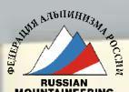
From the base camp in the former houses of the geological party, the path goes to the end of the road, to the clearing at the confluence of the Awadkhara and Mzimni rivers. From the clearing along the right (orographic) bank of the Awadkhara River, there is a trail. Further along the right (orographic) source of the Awadkhara River with a gradual gain in height - exit to the snow circus formed by a section of the Main Caucasian Ridge with the peaks Kardyvach – Uzlovaya and Kardyvach – Main and two spurs.
The left spur along the way is the Kutekhekhu ridge, the right one is Nameless. From the circus, the pass of 13 is clearly visible, but the path to it is blocked by a belt of "ram's foreheads." In the left part of this belt, there is a passage in the form of a snow tongue. Further movement is up to the right towards a clearly marked lowering in the ridge. On the pass - a control cairn.
The approach takes 4–5 hours.

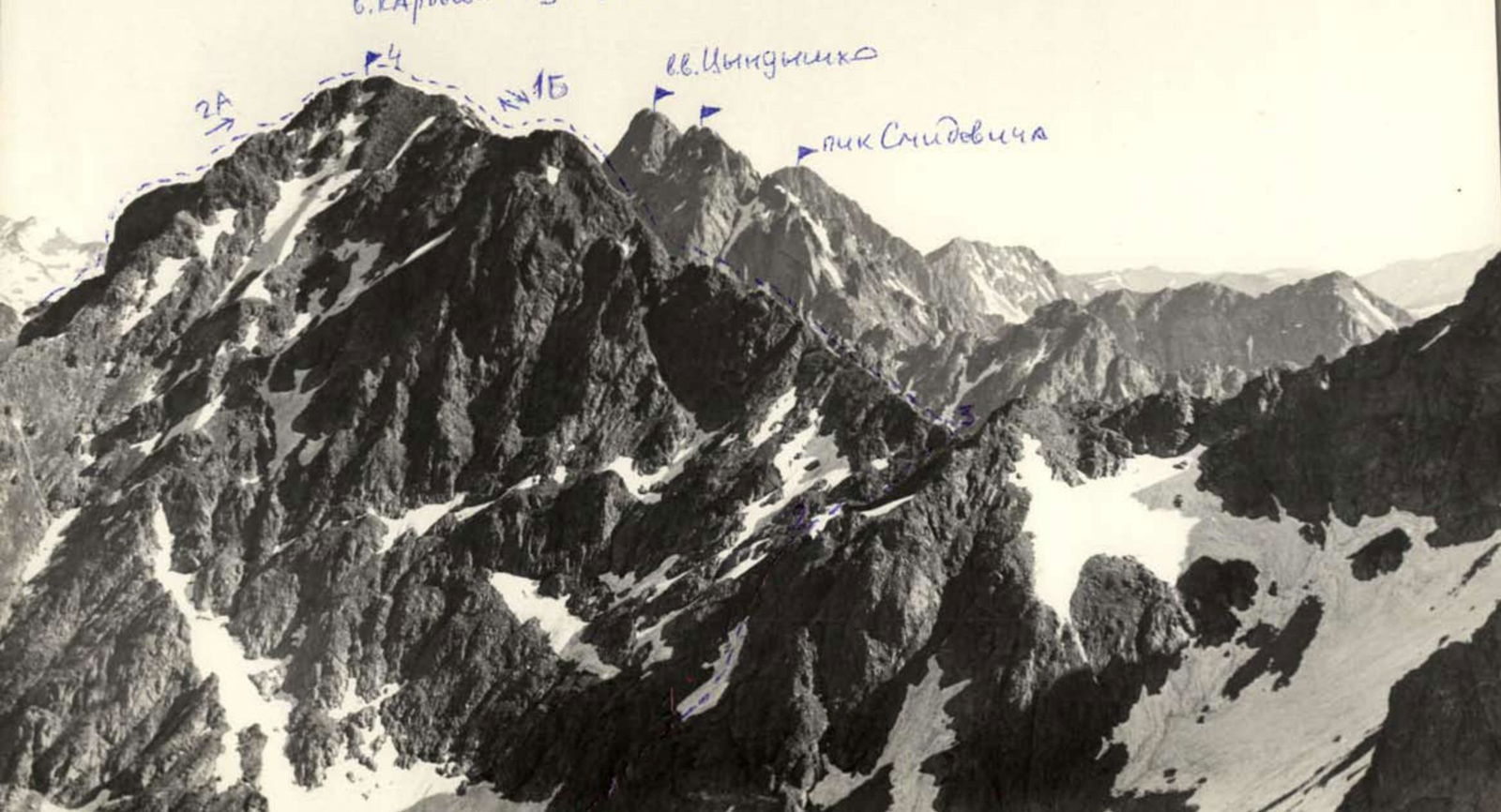
| Date | Designation | Length (m) | Terrain characteristics | Difficulty | Condition | Weather conditions | Pitons driven: rock | Pitons driven: ice | Pitons driven: bolted | Passage of sections: rock | Passage of sections: ice | Passage of sections: bolted | Travel time (h) | Overnight stay conditions |
|---|---|---|---|---|---|---|---|---|---|---|---|---|---|---|
| 13-77 | R0–R1 | 150 | rocky snow | 1 | destroyed | good snow cover | 0 | 0 | 0 | 0 | 0 | 0 | 3–4 | - |
| " | R1–R2 | 80 | - | 2 | - | - | 0 | 0 | 0 | 0 | 0 | 0 | - | - |
| " | R2–R3 | 60 | - | 2 | snowed | - | 0 | 0 | 0 | 0 | 0 | 0 | - | - |
| " | R3–R4 | 400 | - | 1 | destroyed | snowed | 0 | 0 | 0 | 0 | 0 | 0 | - | - |
Route Description
From pass 13, left up along simple destroyed rocks along a wide ridge, section R0–R1 - 150 m (25–30 min).
Further, a steep shaft of destroyed rocks - 15 m. If there is snow, it is a hazardous place. Careful belay through footholds is necessary.
Further along rocks of medium difficulty and a small gendarme, section R1–R2 (25–30 min).
The gendarme is bypassed on the left along the snowy slope and then up to the left along the steep ridge (2 ropes). Exit to the ridge on the right side, from the snow.
Further, a 2; 5 m wall goes to the left straight on. The ridge leads to the forepeak, section R2–R3 (2 hours).
From the forepeak, a counterfort departs, along which the classified route 2B category of difficulty passes.
Along the gentle ridge to the summit - section R3–R4 (20 min).
Descent along the ascent path or along route 1B category of difficulty along the southern slopes of the summit.