Ascent Passport
| Climbing Category | — | Rock climbing |
|---|---|---|
| Climbing Area | — | Western Caucasus, North-West spur of Sofiyskiy ridge between Pshish and Sofiya rivers. |
| Expected Difficulty Category | 4A | |
| Route Characteristics | — | Rock climbing, absolute height difference 320 m. |
| Pitons hammered, chocks placed | — | 34 |
| Number of climbing hours | — | 7 |
| Number of overnight stays | — | The route is completed within daylight hours |
| Climbing Team Leader | Fedorov B.V. — 1st sports category, 357748 Kislovodsk, Pomenko st. 108–9. | |
| Team Members | — | Koblyakov V.M. — 1st sports category |
| Bobylyov V.D. — 1st sports category | ||
| Observers | — | Zaporozhchenko E.V. CMS |
| Gorda R.A. CMS | ||
| Team Coach | — | Popov V.P. Master of Sports of the USSR |
| Date of departure on the route and return | — | July 30, 1984 |
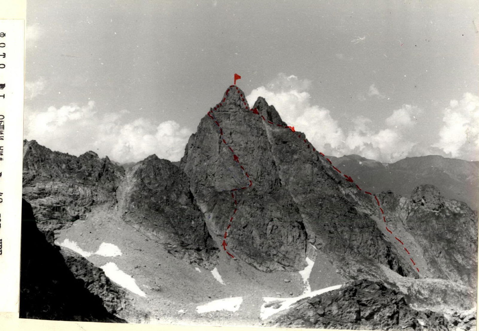
Route of the second ascent to the peak "40 years of NRB"
3201 m
Route of the second ascent to the peak "40 years of NRB". Approximately 4A category of difficulty. Height: 3201 m. Scale: 1 cm — 10.5 m.
- — ascent path
- — descent path
The unnamed peak 3201 m is located in the North-West end of the Sofiyskiy ridge. It stands out clearly as an independent peak and has the appearance of an imposing tower. The first ascents to all neighboring peaks were made by climbers from the Stavropol Regional Sports Committee in 1982. The most straightforward route for a wall ascent to the peak "3201" appears to be the route along the South-Western part of the wall.
For summer conditions, it is best to overnight near the lake below the peak Peshtera (see the overview orographic scheme). From the base camp "Ledovaya ferma" through the passes Ozerny and Septemvri, it takes 3–4 hours to approach. From the indicated overnight stay, move under the slopes of peaks Batak, BSD, towards the rocky tower located to the right of peak Dimitrov-100. From the assault camp, it takes 45–60 minutes. The beginning of the route is easily identified by the couloir cutting through the ridge between peaks Dimitrov-100 and 3201 m, with a characteristic sentinel "Palets" (Finger) at the top (see photo № 2).
Route Description
(See sketch, photo 1, table).
Section R0–R1: Start of the route: a large stone at the beginning of the couloir expansion and a triangular small snowfield. From it begins a steep, in the lower part smoothed, inner corner, 7–8 meters up to the cornice. Limited number of good holds (85°, 4+, 2 pitons). The cornice is passed from right to left using an artificial foothold (95°, 4+, piton, ladder). Further, the inner corner flattens to 70° (30 m, 4+, 4 pitons), through the last piton — a runner to move left into a niche under the overhang. Control cairn.
I. Crux: the cornice is passed from left to right. Under the cornice — a small ledge for one person. Requires careful belay (95°, 4+, 2–3 m, piton, 3-step ladder). Above the cornice, in its right part — a small handhold.
Section R1–R2: Further, a small inner corner leads to steep grassy ledges. Through them straight up to the wall. Loose rocks! Under the wall on a horizontal ledge, there are good rock outcrops, suitable for organizing belay or running belays (65°, 3+, 40 m, 3 pitons).
Section R2–R3: Along the ledge to the right. The ledge is narrow, grassy, местами osypnaya. Move to an uneven platform with stones on an implicitly expressed counterfort. Belay via outcrops. On the platform, an overnight stay is possible (30°, 40 m, 2+).
Section R3–R4: From the platform, a steep and wide ledge goes left, starting with a small 3-meter wall. In the upper part, the ledge is interrupted by small 2–3 m walls. Up the ledge, sticking to the right side, to the narrowing, which is under the overhang, turning into a narrow couloir (70°, 80 m, 4+, 2 pitons, 4 chocks).
Section R4–R5: The couloir abuts a rocky overhang, which is bypassed on the left with ascent and transition to a narrow, steep ledge. To the right is a wall (80°, 40 m, 4+, 3 pitons, 3 chocks).
Section R5–R6: Along the ledge, turning into an inner corner, leading to a narrow ledge, winding around a sentinel to a platform (overnight stay possible). From the ledge to the right up along the destroyed slabs to the base of the monolithic wall (60°, 60 m, 3+, 2 pitons, 1 chock).
Section R6–R7: I. Crux. Along the center of the wall of the summit tower — straight up, limited number of holds, местами сглажено. After 40 m, the wall becomes less steep and turns into a large-boulder talus. At the summit, a small platform. The note of the first ascenders Zaporozhchenko–Gorda was retrieved. On this section, it is advisable to wear galoshes; in the upper part, it is necessary to move carefully — ROCKFALL IS POSSIBLE!!! For the ascent, 2 ladders, petal pitons are necessary (90°, 50 m, 5+, 9 pitons, 2 ladders).
The route is completed in 8 hours, the expected difficulty category is IV A. The route is more challenging than 4A on peak Ertzog, peak Cheget Kara Bashi, and very similar to the Systrov route on peak Dombay-Ulgen, but shorter.
Descent from the summit along the eastern ridge to the saddle (40 m, 45°, 2+). From the saddle, a diagonal rappel 20 m to a ledge and along it, bypassing the sentinel, exit to the eastern ridge and along it to the peak XIX Congress of the Komsomol. From the peak, descent via route 2B in winter with alternating belay, 2 hours.
Recommendations
- On the route, in good weather, galoshes are necessary.
- After the rappel, descent along the ledges is not recommended, as they end in rockfall.
- It is necessary to bring water on the route — there is no water along the entire route.
- Emergency descent only via the ascent path.
For a group of 4 people.
Equipment
- Rock hammer — 2 pcs.
- Rock pitons — 10–12 pcs.
- Main rope — 2 × 40 m.
- Galoshes — 2–3 pairs.
- Chocks — 5–6 pcs.
Table
of the main characteristics of the route of the second ascent to the peak "40 years of NRB"
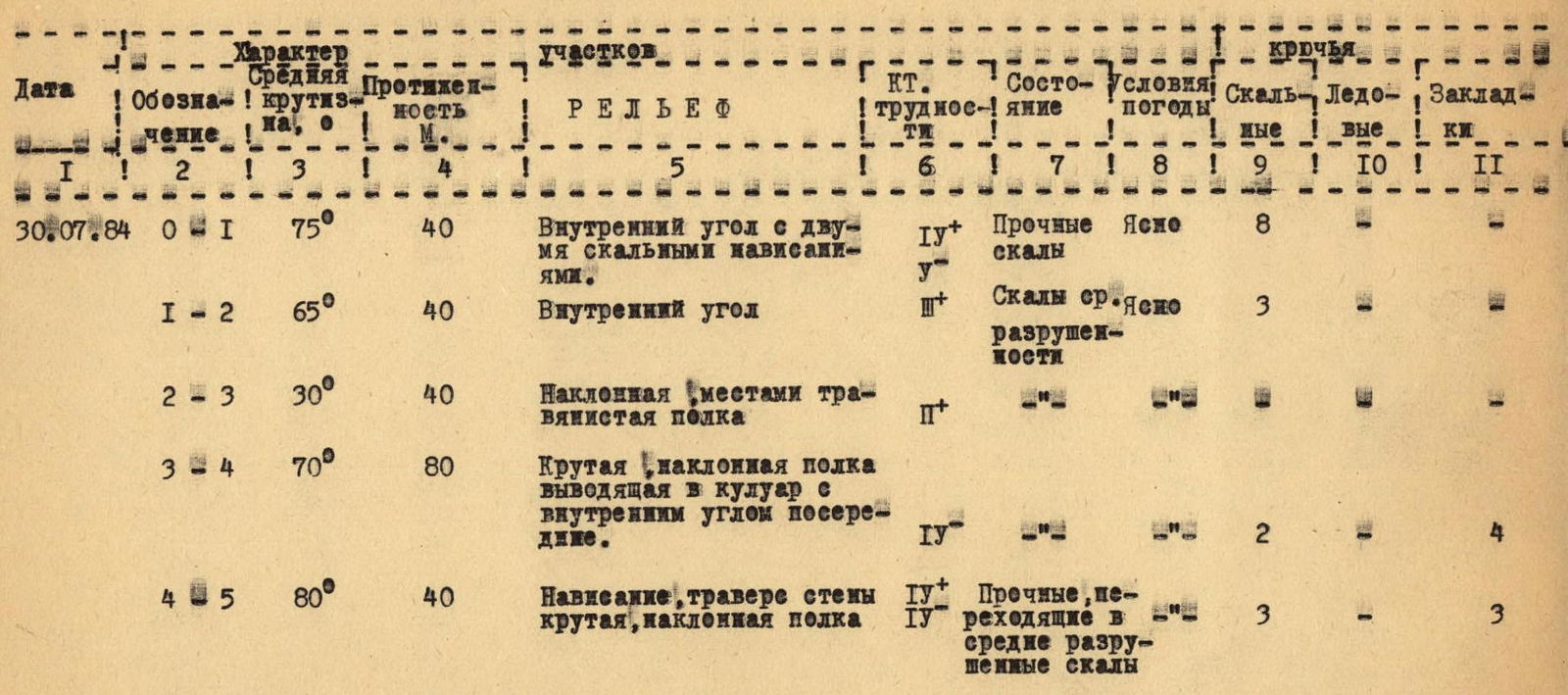
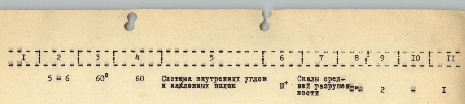
| Date | Designation | Average slope, ° | Length, m | Relief | Cat. diff. | Rock condition | Weather conditions | Rock pitons | Ice pitons | Chocks |
|---|---|---|---|---|---|---|---|---|---|---|
| 30.07.1984 | R0–R1 | 75 | 40 | Inner corner with two rocky overhangs | 4+ | Solid | Clear | 8 | ||
| R1–R2 | 65 | 40 | Inner corner | 1 | Rocks of average destruction | Clear | 3 | |||
| R2–R3 | 30 | 40 | Inclined, местами травянистая полка | 2+ | ||||||
| R3–R4 | 70 | 80 | Steep inclined ledge, leading to a couloir with an inner corner in the middle | 4 | 2 | 4 | ||||
| R4–R5 | 80 | 40 | Overhang, traverse of the wall, steep inclined ledge | 4+ | Solid, turning into rocks of average destruction | 3 | 3 | |||
| R5–R6 | 60 | 60 | System of inner corners and inclined ledges | 3+ | Rocks of average destruction | 2 | 1 | |||
| R6–R7 | up to 90 | 50 | Wall | 5+ | Monolithic rocks | 9 | 2 |
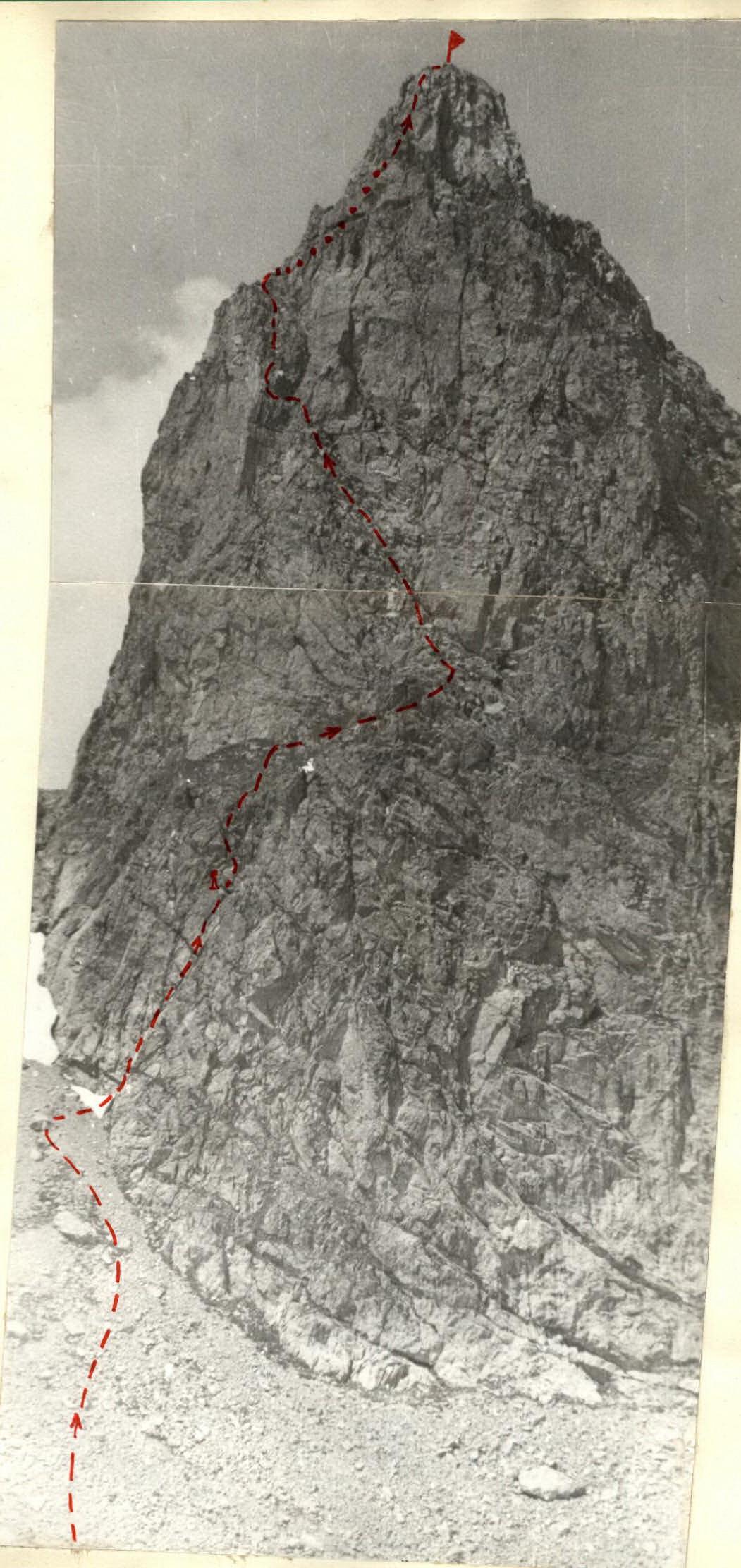
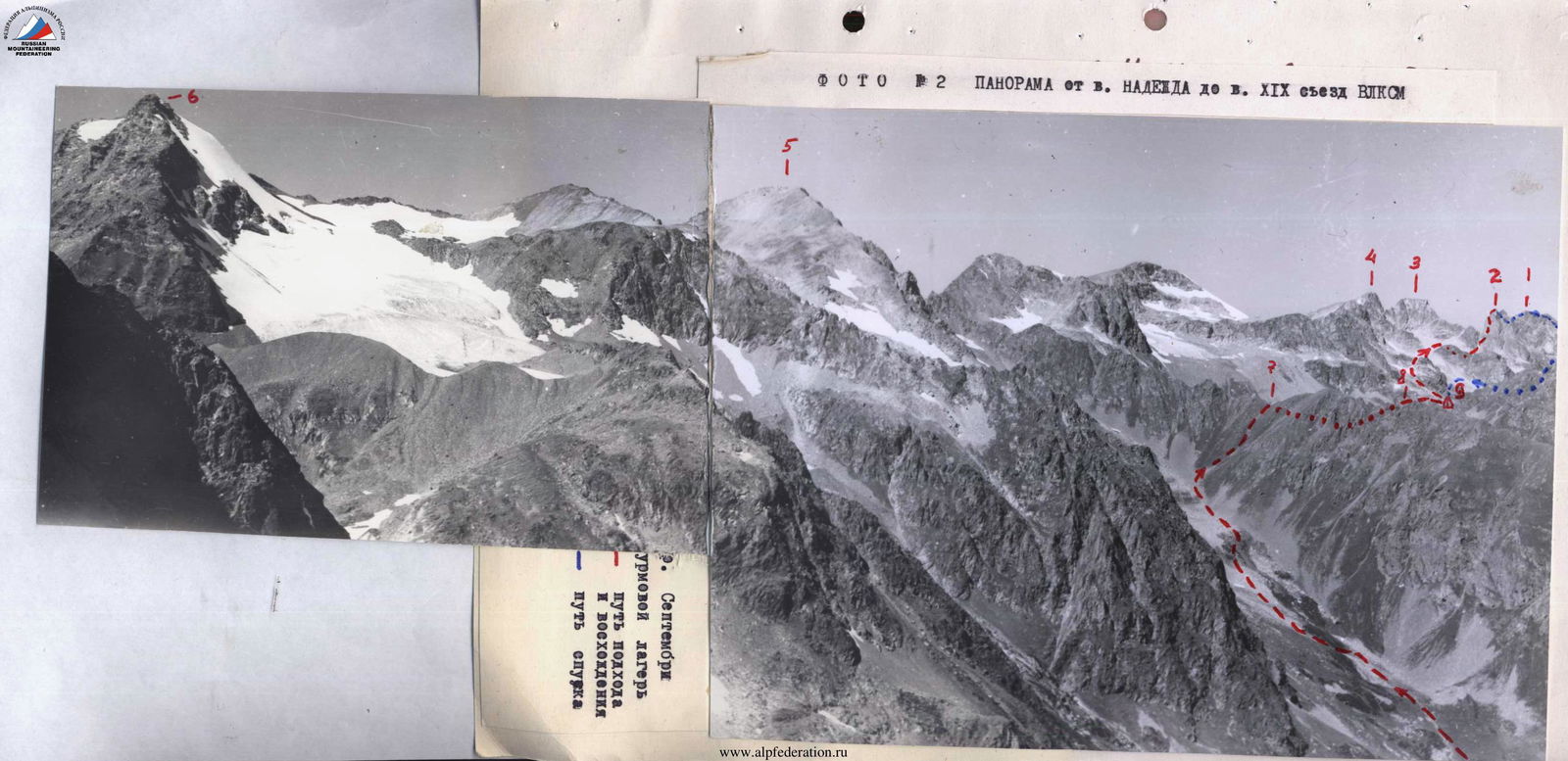
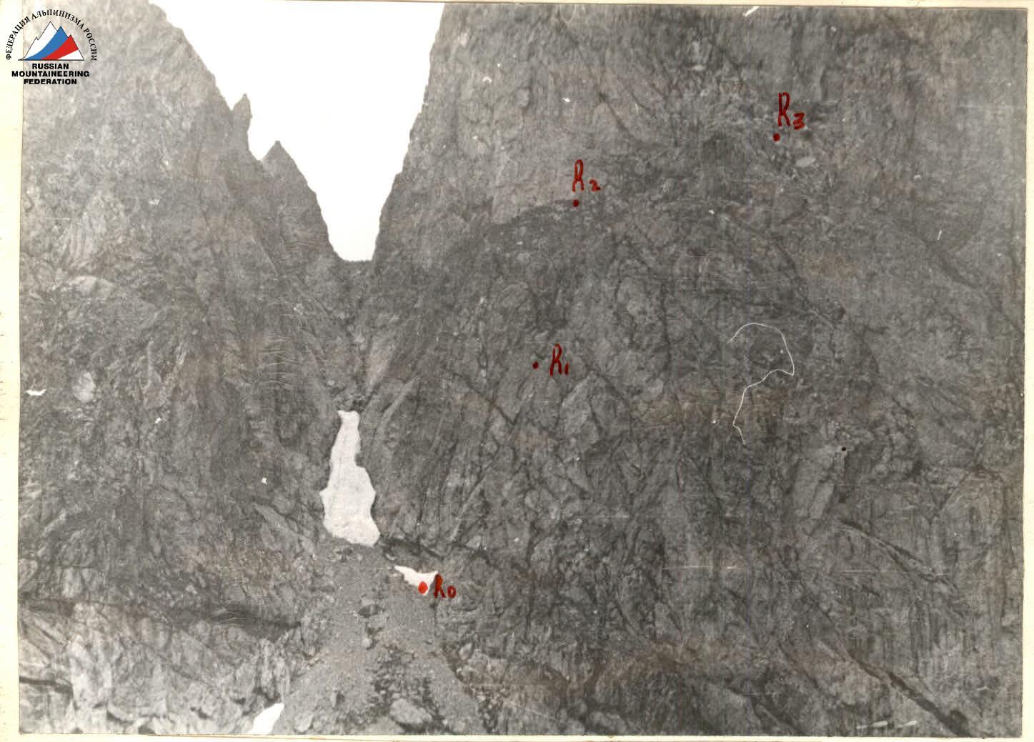 PHOTO 5 Section of the route R0–R1
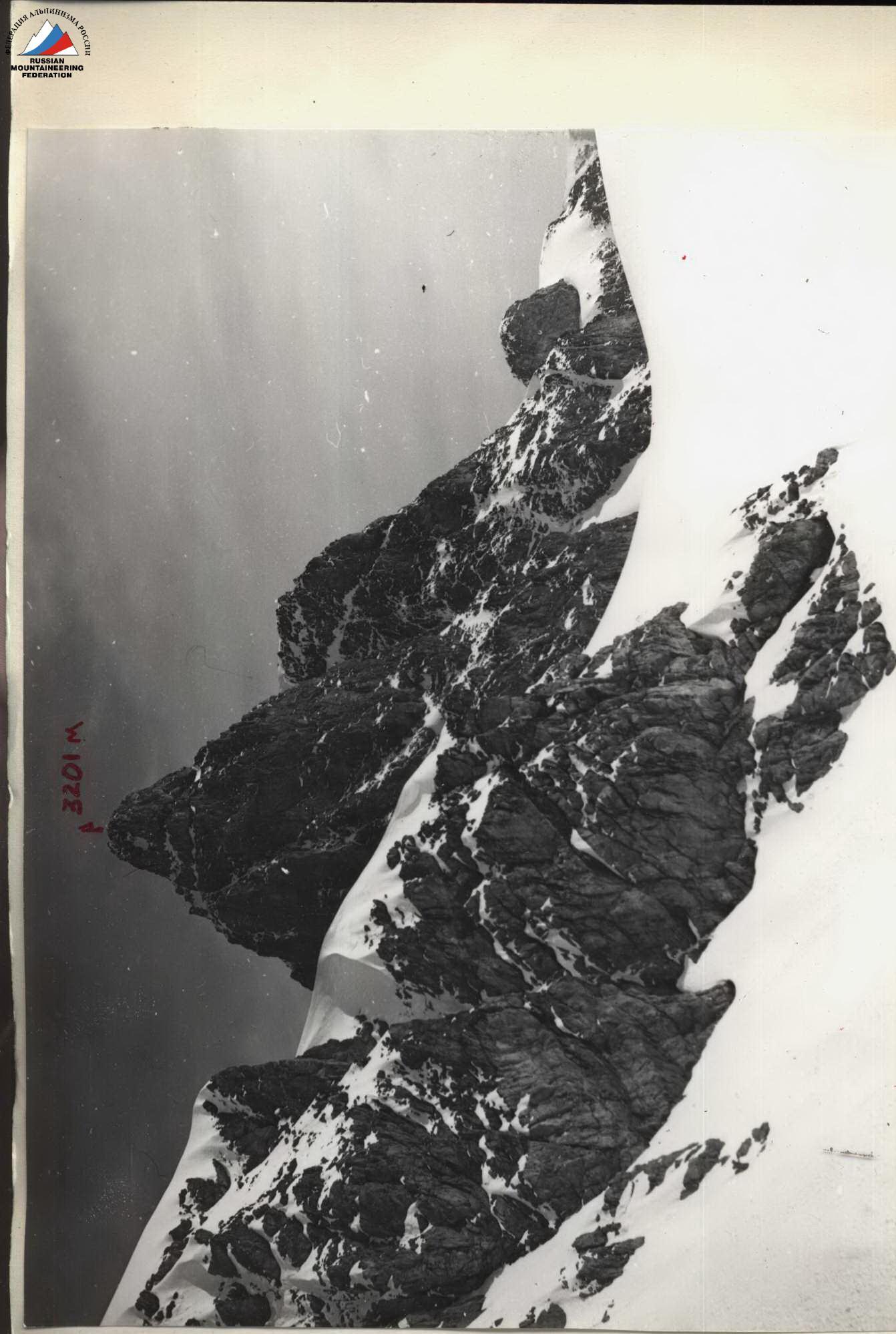 PHOTO 3 peak "40 years of NRB" from the saddle between peak BSD and peak BKP
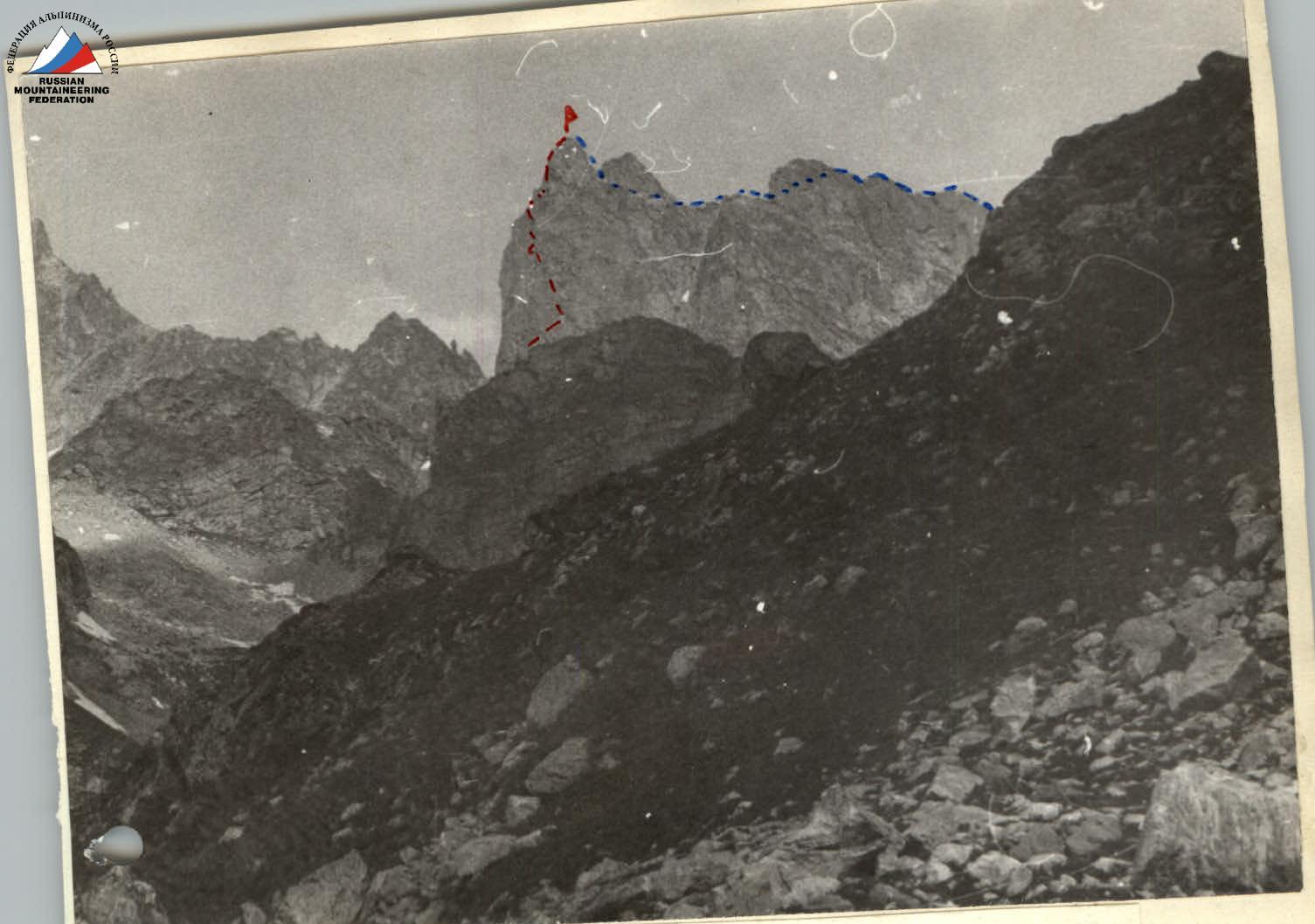
PHOTO 10 View of peak "40 years of NRB" from the base camp

PHOTO 11 Profile of the section R6–R7 and the descent path from the summit