Technical Description of the Route
Mt. Kush-Kaya (627 m), 22. "Algoritm" (Algorithm), 5B cat.
scl.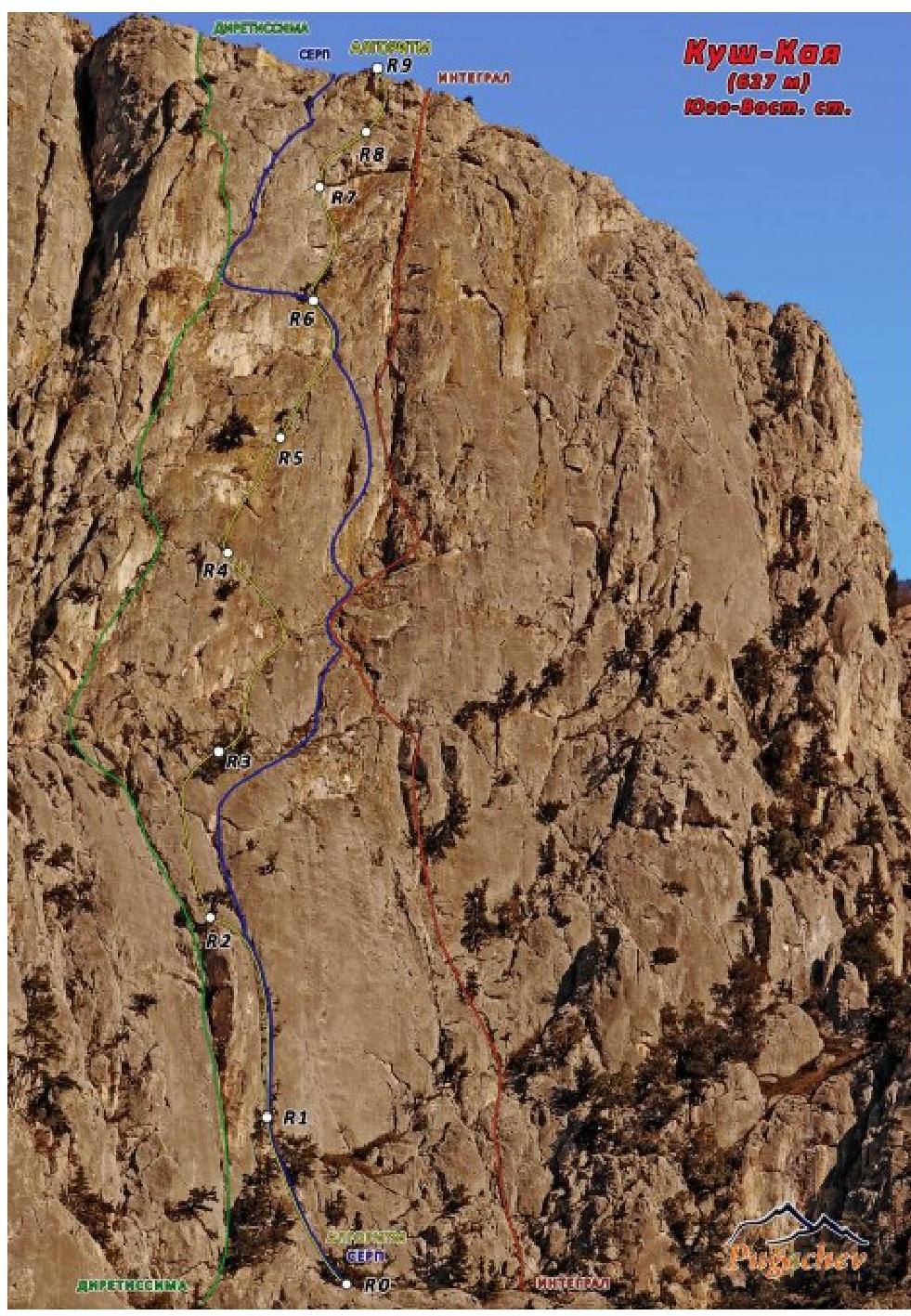
Here's a story about how it was. https://www.risk.ru/blog/208185↗
From the "Kush-Kaya" camping parking lot, we go right - up in the direction of the popular "Integral" route. Seeing a sign for the start of the multi-pitch "Sabotage 7B+" route, we turn left. We see a "leaning" two-rope "pillar" against the wall. To the right of the large pine tree, the "Serp" (Sickle) route begins. We started on "Serp", but we recommend starting to the left of the "pillar" on "Diretissime". There, the clean and beautiful climb leads through two ropes to a pine tree on top of the "pillar".
R0–R1: 30 m, III, 60°
The section includes movement through pine trees.
R1–R2: 42 m, III–IV, 70°; from the large pine tree - movement up through an obvious crack-chimney. A lot of fir needles. There are two old hooks. Exit to a pine tree on top of the "pillar".
- "Serp" - not reaching 10 m to the pine tree, goes along the same crack to the right and up.
- "Diretissme" - without reaching the pine tree, goes left through a chimney and cooling slabs.
R2–R3: 32 m, V+, 80°, A1; from the pine tree - through a narrow, overhanging crack, non-obvious in its lower part. Direction - a small group of pine trees above. Station - on a large pine tree.
R3–R4: 50 m, IV+, 70°; From the station on the tree - up to the right through gentle slabs. Along the large relief, we bypass to the right a rusty overhanging wall. Through an obvious diagonal gap, we exit to a station on a deciduous tree.
R4–R5: 30 m, V+, 85°, A1; From the pine tree - up to the right with aid climbing through a destroyed crack. By-passing a small cornice to the right - exit to a small pine tree.
R5–R6: 35 m, V, 70°, A1; From the station to the right and up through a crack for 25 m. From here, the "Serp" route joins from the right. Together, they go 12 m to a pine tree on a narrow, long ledge. Then "Serp" goes left on a long traverse.
R6–R7: 35 m, VI, 80°, A2; from the station to the right for 10 m, and then sharply to the left, climbing under vertical slabs. Then aid climbing through overhanging slabs with poor relief (skyhooks), we move up the slab to the left part of a large cornice. Organization of a hanging station.
R7–R8: 27 m, VI+, A2, 100–85; movement up the overhang to a bolt. We move to the right crack. Difficult traverse to the right. Then movement to a small pine tree. Organization of our own station on anchors.
R8–R9: 28 m, V, 75–95, A1. From the station:
- to the right - up through slabs under a large summit overhang;
- a short move to the right - straight up (can be bypassed with a long traverse to the left, leaving a point on a ledge under the cornice for the second). Station on the yayla.
Recommendations for climbers. A good long fifth category route, requiring participants to perform complex technical maneuvers. Stations are mostly on trees. There is one bolt. The amount of climbing work is significant. Recommended for well-prepared teams during a long daylight period.
Ascent Passport
- Summit Kush-Kaya, South-East wall (627 m).
- Route "Algoritm" (Algorithm), cat. diff. 5B.
- Route characteristics:
height difference of the wall part of the route - 215 m; route length - 281 m; length of sections with V–VI cat. diff. - 187 m.
- Average steepness of the route from the start of the first-ascent section (R2–R9) - 72.
- Number of bolted hooks - 1.
- Climbing hours - 12 hours
- Participants: Pugachev Sergey Aleksandrovich, MS, instructor-methodologist II cat.
Lapshin Mikhail, CMS (Alushta)
- Team coach: Zagirnyak Mikhail Vasilyevich, Honored Coach.
- Ascent date: August 21, 2016.