Ascent Passport
- Class of ascent — combined.
- Ascent area — Khibiny Mountains.
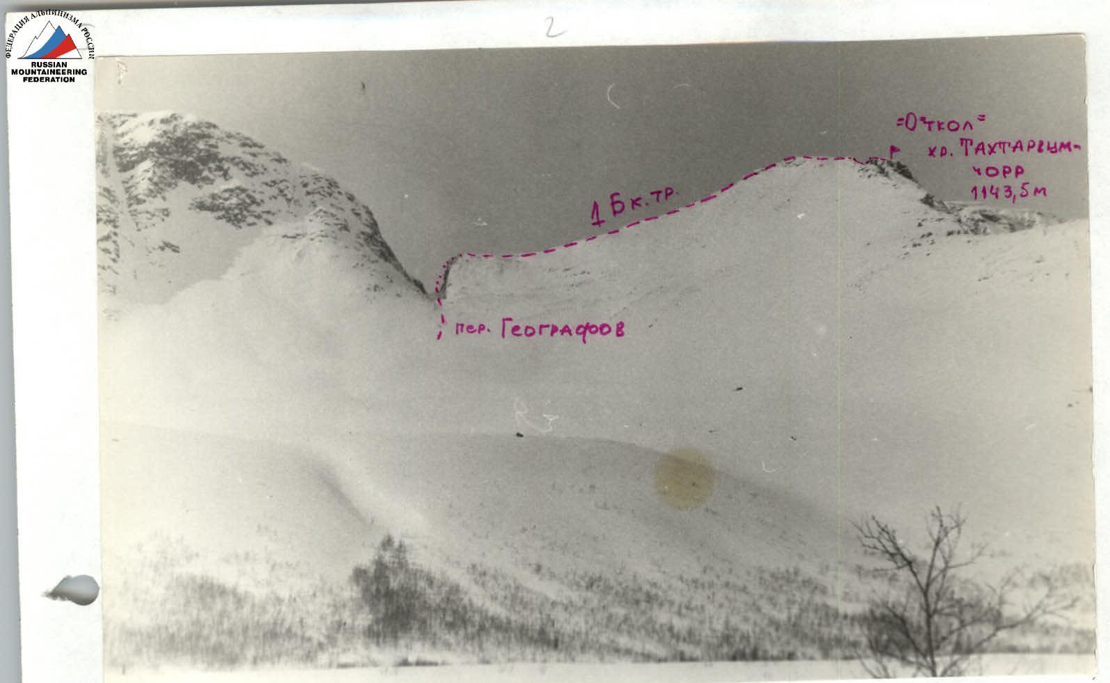
- Peak, its height and route — Takhtarvumchorr ridge, from Geografov pass to "Otkol" of Takhtarvumchorr ridge via South-Eastern ridge, 1143.5 m.
- Estimated difficulty category — 1B cat. diff.
- Route characteristics: height difference — 800 m walls — I — 2000 m Length of sections, cat./tech.: II — 100 m III — 10 m 4 5 Average steepness: overall 40°.
- Pitons driven: for rock protection — 5 chocks ice screws Including used to create artificial holds.
- Number of walking hours — from Geografov pass — 1 h 30 min. from the foot — 3 h.
- Full name of the leader, participants and their qualification:
- Shumilov Oleg Ivanovich — leader, Master of Sports.
- Proskura Alexander Yakovlevich — participant, 1st sports rank.
- Sokolov Evgeny Igorevich — participant, 3rd sports rank.
- Team coach — Shumilov O.I., Master of Sports, 1st category instructor.
- Dates: February 29, 1992.
Description of the first ascent of the route 1B cat. diff. from Geografov pass to "Otkol" of Takhtarvumchorr ridge via South-Eastern ridge.
The approach to the route starts from the village of Kukisvumchorr (25 km) to Lake Maly Vudyavr. From the lake, a valley opens up, ending in a cirque, in the south-eastern slope of which a narrow gap is visible. This is the Geografov pass. The pass serves as a natural boundary between the Takhtarvumchorr and Vudyavrchorr massifs. The path to it goes from Lake Maly Vudyavr. The forest starts near the lake. The ascent to the pass is quite steep, rising in several ledges. It is recommended to stick to the right side, marking the general direction in the fog, and keep landmarks on large individual stones. (General orientation by compass). The height of the pass is 650 m. The pass point is closer to the southern end of the pass. The gorge with sheer walls and overhanging rocks has a gloomy appearance. The length of the pass is 250 m. The bottom of it is a chaotic jumble of rock fragments — in summer, covered with snow in winter. You can get to the village of Kukisvumchorr from the city of Apatity by bus No. 105, or by bus No. 101, No. 102, No. 106 with a transfer at the "Post Office" stop to bus No. 1.
First ascent on February 29, 1992, as part of:
- Shumilov Oleg Ivanovich — Master of Sports of the USSR in alpinism, instructor-methodologist — 1st category.
- Proskura Alexander Yakovlevich — 1st sports rank in alpinism, instructor-methodologist — 3rd category.
- Sokolov Evgeny Igorevich — 3rd sports rank in alpinism with excess.
Equipment:
- Main ropes — 1 × 40 m, 10 mm — 1 pc. — 1 × 40 m, 8 mm — 1 pc.
- Expendable rope — 5 m — 1 pc.
- Ice axes — 2 pcs.
- Ice picks — 5 pcs.
- Rock pitons — 2 pcs.
- Ice screws — 3 pairs.
- Crampons — 7 pcs.
- Carabiners — set-kit.
- First aid kit — 3 kits.
- Down jackets, warm clothing — 3 pcs.
- Backpacks — 3 pairs.
- Skis — 3 pairs.
- Ski poles — 3 pcs.
- Windproof masks — 3 pcs.
- Ski goggles — 1 pc.
- Pamirka tent (silver) — 1 pc.
- Belay harness (belt-sling) — 3 pairs.
- Extension loops — 2 pcs.
- Self-belay loops — 3 pcs.
- Primus stove — 1 pc.
- Thermoses — 3 pcs.
- Fur gloves — 3 pairs.
- Matches, candles.
- Pot (kettle, can) — 1 pc.
- Lanterns — 3 pcs.
- Helmets — 2 pcs.
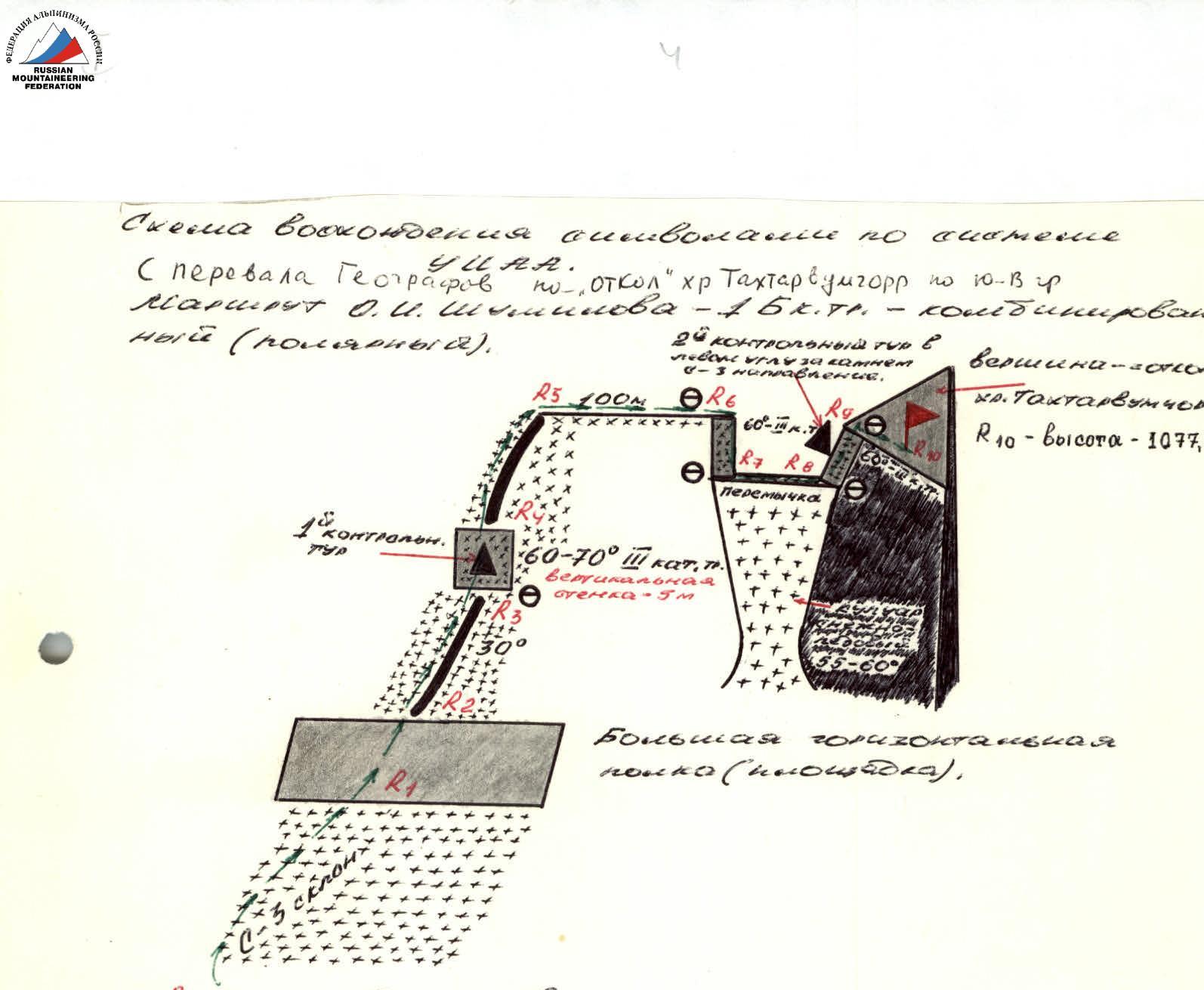
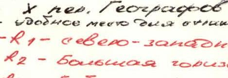
Departure from the village of Kukisvumchorr (25 km) — 10:40. Approach to Lake Maly Vudyavr — 11:40. Ascent to the pass at 11:50. At Geografov pass — 12:55. 13:00 — having passed the pass, immediately to the right up the north-western slope to a wide ridge (platform). Further up the ridge with a steepness of 30° to the left with snow-covered protruding rocks and small ascents, approach to a vertical wall — 5 m steepness 60–70° cat. 3 — (13:45) — piton belay. Above the wall, a control cairn (can on a hook) — 1st key section. Further along the ridge, exit to the plateau of Takhtarvumchorr ridge, at an angle of 30° cross a section of the plateau — 100 m — exit to a gap — 2nd key section, belay through ice axes or piton belay. The width of the bridge is 15 m, depth — 10 m. The bridge is a sharp snow (ice) ridge, steeply breaking off on both sides by couloirs — snow-ice — steepness — 55–60° and length of several hundred meters. At the end of the couloirs, rock walls, stones. Gap — for instructors leading novice groups and badge holders, it is mandatory to pass with the organization of rope railings. Cornices on all sides — require special attention. Exit from the gap to "Otkol" via snow-covered rocks — height 10 m. Piton belay. Cracks are not visible, snow-covered, ice-covered, so you have to check each block and stone. At the top of "Otkol" of Takhtarvumchorr ridge — 14:30. Control cairn in the left corner behind a stone on a hook. Approximately 1B–2A cat. diff. Visibility — 50 m, wind, snow, fog. Time taken to traverse the route from Geografov pass to "Otkol" (Peak) of Takhtarvumchorr ridge — 1 h 30 min. Route length — 650 m. Total time taken from 25 km to the summit — 4 h. For groups arriving in the area for the first time — descent along the ascent route.
Ascent Diagram
Ascent diagram according to the YUAA system. From Geografov pass to "Otkol" of Takhtarvumchorr ridge via South-Eastern ridge. Route by O.I. Shumilov — 1B cat. diff. — combined (polar).
R0 — Geografov pass — a convenient place for an overnight stay. R0–R1 — north-western slope of Takhtarvumchorr ridge. R1–R2 — Large horizontal platform (ledge) — 70 m. R2–R3 — Ridge — 30° with snow-covered protruding rocks — 300 m. R3–R4 — Vertical wall — 5 m (60–70° — cat. 3) piton belay. — control cairn with a can, on a hook. R4–R5 — Ridge — 55 m. R5–R6 — Section of Takhtarvumchorr ridge plateau — 100 m. R6–R7 — Wall — 10 m, leading to a bridge (piton belay). R7–R8 — Bridge — 20 m (belay through ice axe). R8–R9 — Wall — 60° — 10 m, leading to "Otkol" of Takhtarvumchorr ridge. R9–R10 — Exit to "Otkol" of Takhtarvumchorr ridge (Peak) — 20 m. Route length — 650 meters, time taken to traverse the route from Geografov pass to "Otkol" (Peak) — 1 h 30 min. Descent along the ascent route.


