Ascent Passport
1 Northern Urals, Konzhakovsky massif. 2 Yuzhnyy Iov 1311 m — via the right lateral ridge from the slope of Iov collapse.
3 Proposed: 2A category of difficulty, first ascent. 4 Route type: combined. 5 Height difference (by GPS) of the route: 460 m. Route length: 2100 m. Length of sections with IV category of difficulty: 45 m. Length of sections with III category of difficulty: 50 m. Length of sections with II category of difficulty: 100 m. Steepness of the main part of the route: 45°, up to 80° in some areas.
6 No pitons left on the route. 7 protection elements used, 6 slings, 3 of which for anchor stations.
7 Departure from "Serebryansky Kamen" tourist base on March 11, 2014 at 07:50. Departure to the route: March 12, 2014 at 12:00. On the summit: March 12, 2014 at 15:45. Descent from the summit to the bivouac (via the central couloir of Iov collapse): March 12, 2014 at 17:10.
Return to "Serebryansky Kamen" base: March 12, 2014 at 22:15.
8 Team's total time on the route — 5 h 10 min. 9 Team leader: Kolunin Ruslan Nikolaevich, 1st sports category, instructor III category, Karpinsk. Team members:
- Bogoslovsky Andrey Gennadyevich, 3rd sports category, Krasnoturinsk.
- Khairutdinov Igor Sergeevich, 3rd sports category, Krasnoturinsk.
10 Coach: Yermachek Yuri Vladimirovich, Master of Sports of the USSR, instructor II category, Yekaterinburg. Organization: Ural High-Mountain Club "Gorets". 11 Responsible for the report: Kolunin Ruslan Nikolaevich, e-mail: rassel2007@mail.ru, phone: 89068579003
Ascent Route (Photo 1)
The picture is taken from Iov plateau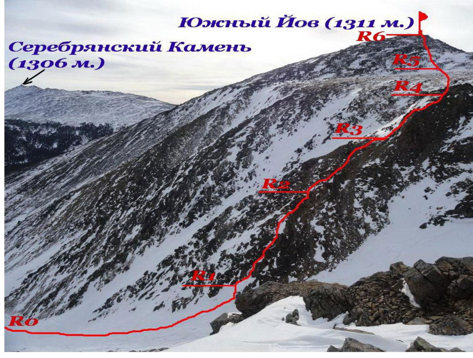
Route Profile (Photo 2)
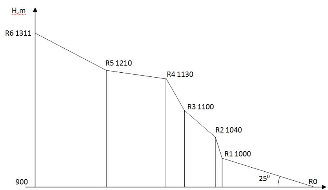
PHOTO PANORAMA OF THE AREA (PHOTO 3) The picture is taken from Sukhogorsky massif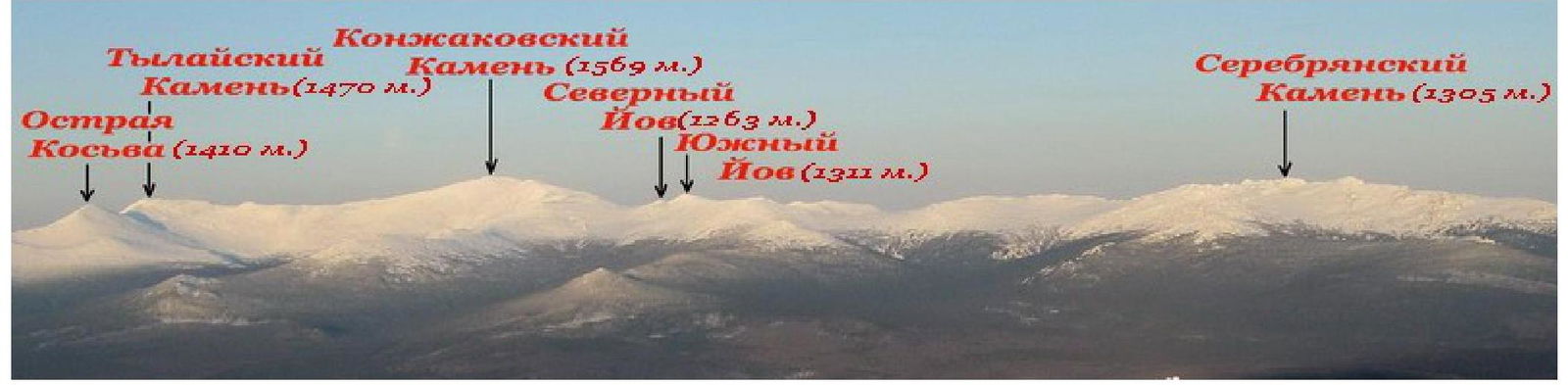
MAP OF THE AREA WITH CLASSIFIED ROUTES (PHOTO 4)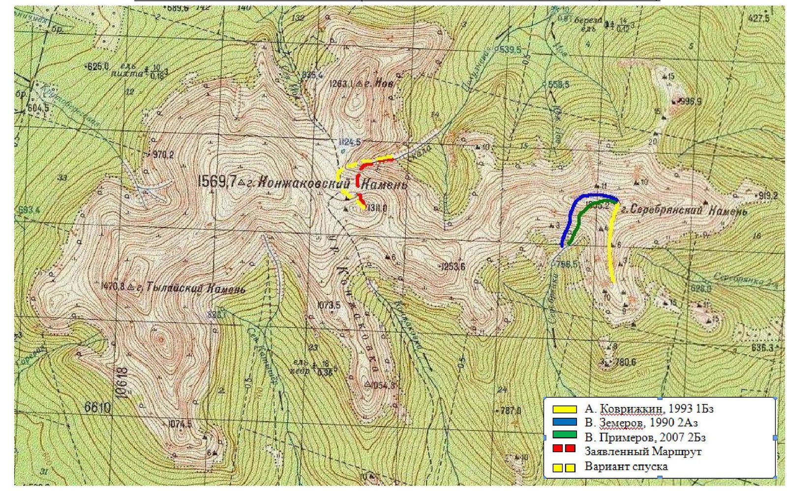
Area Description
Material from http://ru.wikipedia.org/↗
Konzhakovsky Kamen is a mountain in the southern part of the Northern Urals, within Sverdlovsk Oblast (Russia). It is one of the highest peaks of the Ural Mountains (1569 m).
Composed of:
- pyroxenites,
- dunites,
- gabbro.
The lower parts of the slopes are covered with coniferous forests, while above 900–1000 m, there are mountain tundras and stone screes. Named after Konzhakov, a Vogul hunter whose yurt once stood at the foot of the mountain.
The term "Konzhak" among tourists usually refers to a mountain tourist region of the Northern Urals, including several peaks near the settlement of Kytlym in Sverdlovsk Oblast, within the boundaries of the O-40-023 topographic map sheet. This region includes a ridge known as the "Konzhakovsky massif", which includes Mt. Konzhakovsky Kamen, stretching predominantly from west to east, as well as several peaks located south and north of this ridge.
The "Konzhakovsky massif" includes:
- Serebryansky ridge to the east (stretches from W to E, height up to 1100–1300 m);
- "Konzhakovsky" ridge to the west (stretches from SW to NE, height up to 1100–1500 m).
Serebryansky ridge includes Mt. Serebryansky Kamen (1305 m) — the highest point of the ridge, characterized by a large number of rocks on the crest (rocky jagged ridge), and has spurs extending to the north and south. The northern spur is low and narrow, with a height of up to 997 m, while the southern spur is wide, up to 1100 m.
The "Konzhakovsky" ridge includes peaks:
- Mt. Trapezia (1253 m)
- Mt. Yuzhnyy Iov (1311 m)
- Mt. Severnyy Iov (1256 m)
- Mt. Konzhakovsky Kamen (1569 m)
- Mt. Tylaisky Kamen (1471 m)
- Mt. Ostraya Kosva (1403 m)
Notable features on the ridge include:
- Iov plateau with heights up to 1100–1200 m and a lake (water level at 1125 m)
- Iov collapse (eastern slope of Iov plateau) — rocks steeply dropping into the valley of the Poludnevaya River
- Tylaisky collapse — a steep southwestern slope of Mt. Tylaisky Kamen
- "Khudozhnikov's glade" — a glade in the forest in the valley of the Konzhakovka River, a popular spot for campsites among tourists
From the Karpinsk–Kytlym highway to the summit of Konzhakovsky Kamen stretches a so-called "marathon trail" — a marathon path with kilometer markings (one-way length — 21 km).
Route Description
To reach the start of the route, one needs to travel 18 km on skis or snowshoes to the foot of the Konzhakovsky massif. It is also possible to use a snowmobile for the approach. The approach to the route from the "Serebryansky Kamen" tourist base or from the Karpinsk — Kytlym road takes 1 to 2 days. The bivouac is set up on the steep right bank of the Poludnevaya River, from whose frozen riverbed the route begins.
Section R0–R1 is a snow-ice slope (frozen riverbed) with a steepness of 10° initially and up to 25°. Movement should be cautious, as close as possible to the center of this slope, as it is possible to fall into the riverbed in the spring. Movement is in crampons with poles in hand.
Section R1–R2 — the beginning of a rocky counterfort, 45 m long. Movement is via fixed ropes. Steep rocks, the first 5–7 m are covered in ice. Further, there are several inclined rocky ledges with small overhangs up to half a person's height. Protection is with protection elements. Holds are:
- narrow cracks for fingers
- front teeth of crampons
It may be necessary to use IT (Intermediate Technical) equipment. Above the ledges become wider, and it is possible to belay through rocky outcrops. Slings of lengths 120 cm, 160 cm, and 200 cm are needed.
In the upper part of the rocky bastion, there are many loose rocks. The station is on a gentle section on a rocky outcrop.
Section R2–R3 — a rocky ridge with a steepness of 30–45°, 100 m long. Rocks are of II category of difficulty, pleasant climbing while belaying simultaneously. Belaying is through rocky outcrops.
Section R3–R4: The second steep rocky ascent, leading to the edge of Iov plateau. Movement is via fixed ropes. The route upwards goes through a chimney with dense firn and ice. Further — without climbing to the very top of the rocky gendarme — along a ledge to the left onto the ridge leading to the plateau. The station is on a rocky outcrop on the ridge.
Section R4–R5:
- Gentle, traversed on foot
- It's better to put the rope away in a backpack
- We move along Iov plateau to the south, gradually ascending onto stony screes
- Section length — 350 m
Section R5–R6 — a large-block scree with a slope of 25°. One should choose sections with dense snow. The section does not present technical difficulties.
The summit itself is a rocky outcrop 5–7 m high. In strong winds, it's advisable to use belay systems when near the summit cairn.
The descent to the bivouac is via the ascent path from Iov plateau and further down the snow-ice central couloir of Iov collapse from the slope of Mt. Konzhakovsky Kamen.
Recommended equipment:
- belay systems
- helmets
- dynamic rope for a rope team 50 m
- crampons
- ice axes
- a set of stoppers
- a set of friends
- long slings 4–5 pieces
Table of Main Route Characteristics
Table 1 — Route Description by Sections
| Section | Time | Height, m | Length, m | Steepness, degrees | Terrain Type | Category of Difficulty | Belaying |
|---|---|---|---|---|---|---|---|
| R0 | 12:0 | 900 | 600 | Up to 25° | Snowy slope | I | Simultaneous |
| R1 | 12:2 | 1000 | |||||
| R1 | 12:2 | 1000 | 45 | 80° | Rocks | IV | Ropes |
| R2 | 13:1 | 1040 | |||||
| R2 | 13:1 | 1040 | 100 | Up to 45° | Rocky ridge | II | Simultaneous, through rocky outcrops |
| R3 | 14:0 | 1100 | |||||
| R3 | 0 | 1100 | 50 | 65° | Rocks | III | Ropes |
| R4 | 14:3 | 1130 | |||||
| R4 | 14:3 | 1130 | 350 | Up to 15° | Scree covered in snow | I | - |
| 5 | |||||||
| R5 | 14:5 | 1210 | |||||
| R5 | 0 | 1210 | 950 | Up to 30° | Large-block scree | I | - |
| R6 | 15:45 | 1311 |
PHOTO FROM THE ROUTE PHOTO 5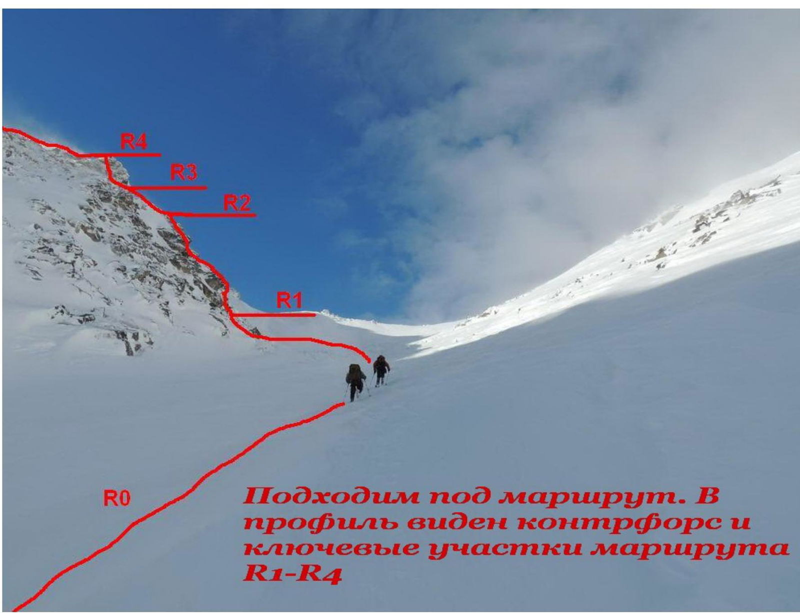
Approaching the route. The counterfort and key sections of the route R1–R4 are visible in the profile PHOTO 6
Passage of Section R1–R2 led by Kolunin R.N.
PHOTO 7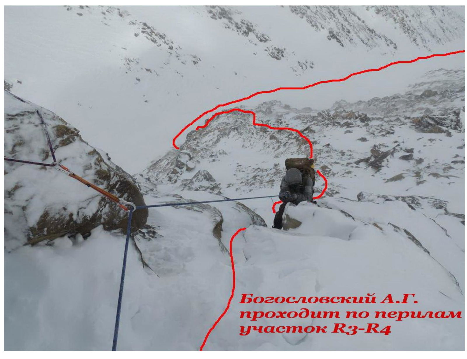 PHOTO 8
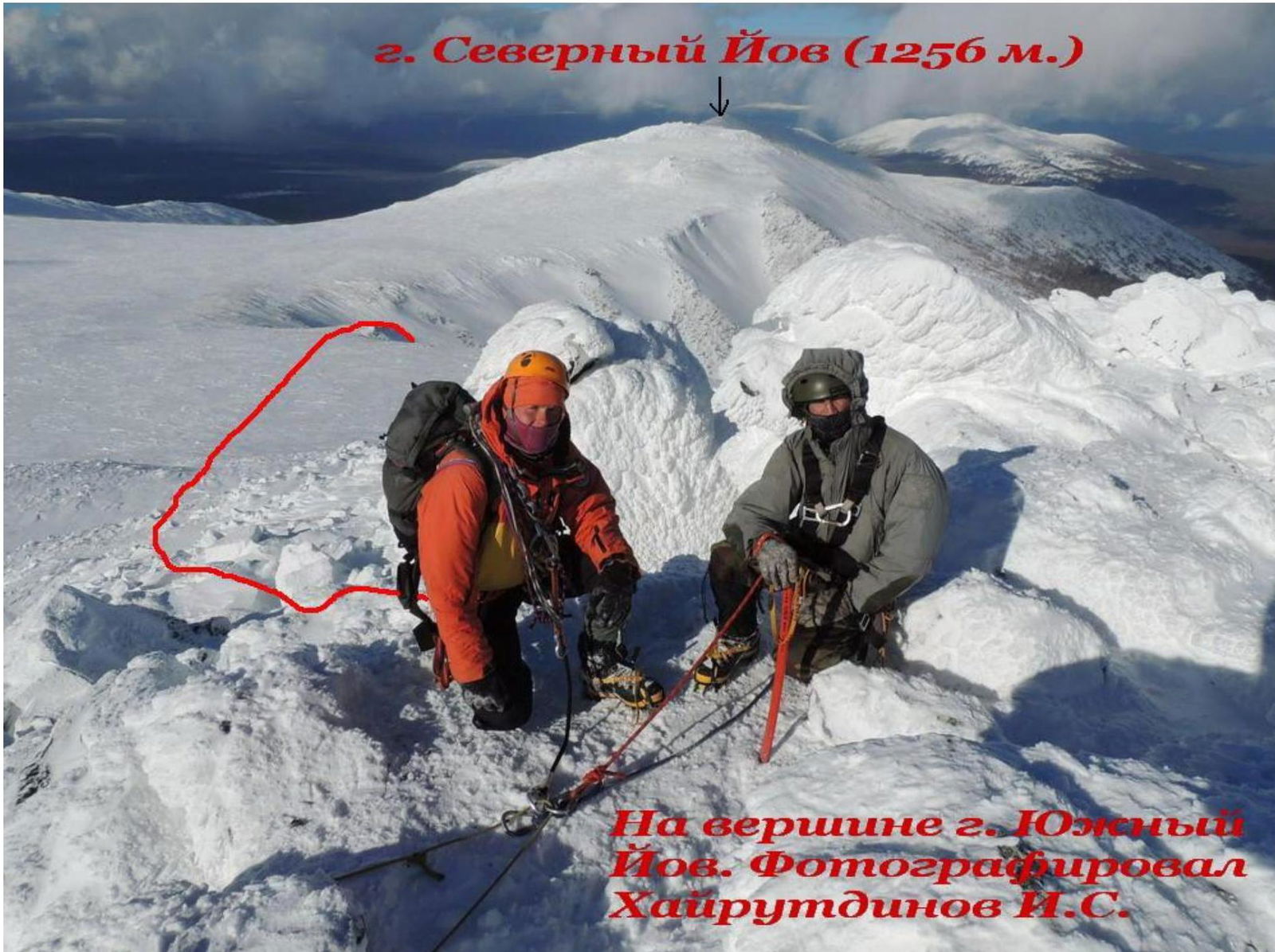
- Severnyy Iov (1256 m)