
Passport
- Section number according to KMGV — 2010 — 8.3. 64
Polar Urals, Raiiz mountain range, Yenga-Yu river valley
- Name of the peak: 1001.0 (Chyornyaya Vostochnaya)
height: 1001.0 m; route: via the northwestern ridge.
- Category of difficulty: 1B, pp.
- Character of the route — combined.
- Height difference of the route: 600 m
- Length of the route: 3000 m
- Length of sections with the highest category of difficulty:
1–900 m, 2–2200 m, 2+–150 m, 3–0 m, 4–0 m, 5–0 m, 6–0 m.
- Average steepness: main part of the route — 65 degrees.
entire route — 45 degrees.
9. Pitons used:
Total pitons used on the route:
- Rock pitons — 0
- Chocks — 4
- Stationary pitons — 0
- ITO — 0
- Removable pitons — 0
Pitons left on the route: total — 0; including pitons — 0.
- Departure on the route — 7:00, November 2, 2010
Reached the summit — 15:30, November 2, 2010. Returned to BL — 18:00, November 2, 2010
- Team's walking hours: 9 hours.
- Leader: Zhuravlev Sergey Vasilievich, CMS, instructor 1st category
Participants:
- E. Burtsev (3rd category, Syktyvkar)
- K. Tolstikov (3rd category, Syktyvkar)
- Coach: Zhuravlev Sergey Vasilievich, title — CMS, instructor-methodologist 1st category.
Description of the peak
The peak Chyornyaya (Vostochnaya) is one of the peaks of the Raiiz mountain range, located in the Yamalo-Nenets Autonomous Okrug (YNAO) of the Tyumen Oblast, Ural Federal District of the Russian Federation, on the eastern slopes of the Polar Urals, 50 km southeast of the settlement of Kharp, in the valley of the Yenga-Yu river (right-bank tributary of the Sob' river).
It is the easternmost peak of the Chyornyaya mountain. The peak is dome-shaped, with a height of 1001.0 m.
The peak Chyornyaya (Vostochnaya) can be an object for training and sports ascents, as it has:
- several pronounced rock ridges,
- corrie ridges on the northern slope,
- a northeastern corrie cirque on the northern slope.
The name of the mountain is official and is found on maps of the Polar Urals; orographic clarifications of the peaks (Vostochnaya, Centralnaya, etc.) are given for the convenience of orientation for mountaineers.
Description of the route: "via the northwestern ridge".
Route: "via the northwestern ridge 1B category of difficulty (combined)" — a typical training route of the second category of difficulty, with a full set of natural obstacles corresponding to routes of this level of difficulty.
Climbing this route has not only aesthetic but also sports-practical significance, as it allows for working out belaying and self-belaying techniques on rock and snow-ice terrain within the ascent.
The route is ridge-like and objectively safe in the winter period, making it suitable for training and sports ascents.
Equipment
For a climb in the composition of a training and sports group of 6 people (5 participants + instructor), the following special equipment is necessary on the route:
Personal:
- Standard issue
- Crampons
- Ice axe (mandatory)
Group:
- Main rope 10 mm — 3×50 m
- Rock hammer — 1 piece
- Rock pitons — 6 pieces
- Ice axe — 1 piece
- Chocks — 6 pieces
- Ice screws — 3 pieces
- Quickdraws — 6 pieces
- Slings — 8 pieces.
Approach
From the base camp — "Balok dorozhnikov", located near the road leading from Kharp to the mine, cross the Yenga-Yu river (4 km — 1.5 hours), then enter the canyon of the corrie cirque. At the beginning of the canyon, there is a convenient place for organizing rope teams.
Technical part
From the canyon, ascend via the talus lap to the base of the rock ridge. Then, ascend along the heavily jagged ridge. When possible, bypass the gendarmes on the right along the talus terraces and ledges.
The key section of the route is the passage of the "Grebënka" section after exiting onto the first rock shoulder. The "Grebënka" section is a series of large gendarmes 10–15 m high, passable "en face".
After passing the gendarmes of the "Grebënka" section:
- exit onto a heavily destroyed rock ridge;
- move along the ridge to a smoothed wall;
- descend to bypass the wall on the right;
- traverse the slope with an exit to a steep snowy (in summer — talus) couloir;
- ascend via the couloir to the second rock shoulder.
Then, the ridge becomes more gentle and leads to the talus dome of the summit. The ascent via the large-block talus to the summit dome does not present difficulties.
Descent from the summit
Via the eastern couloir of the northeastern corrie cirque of the northern slope (route 1B category of difficulty).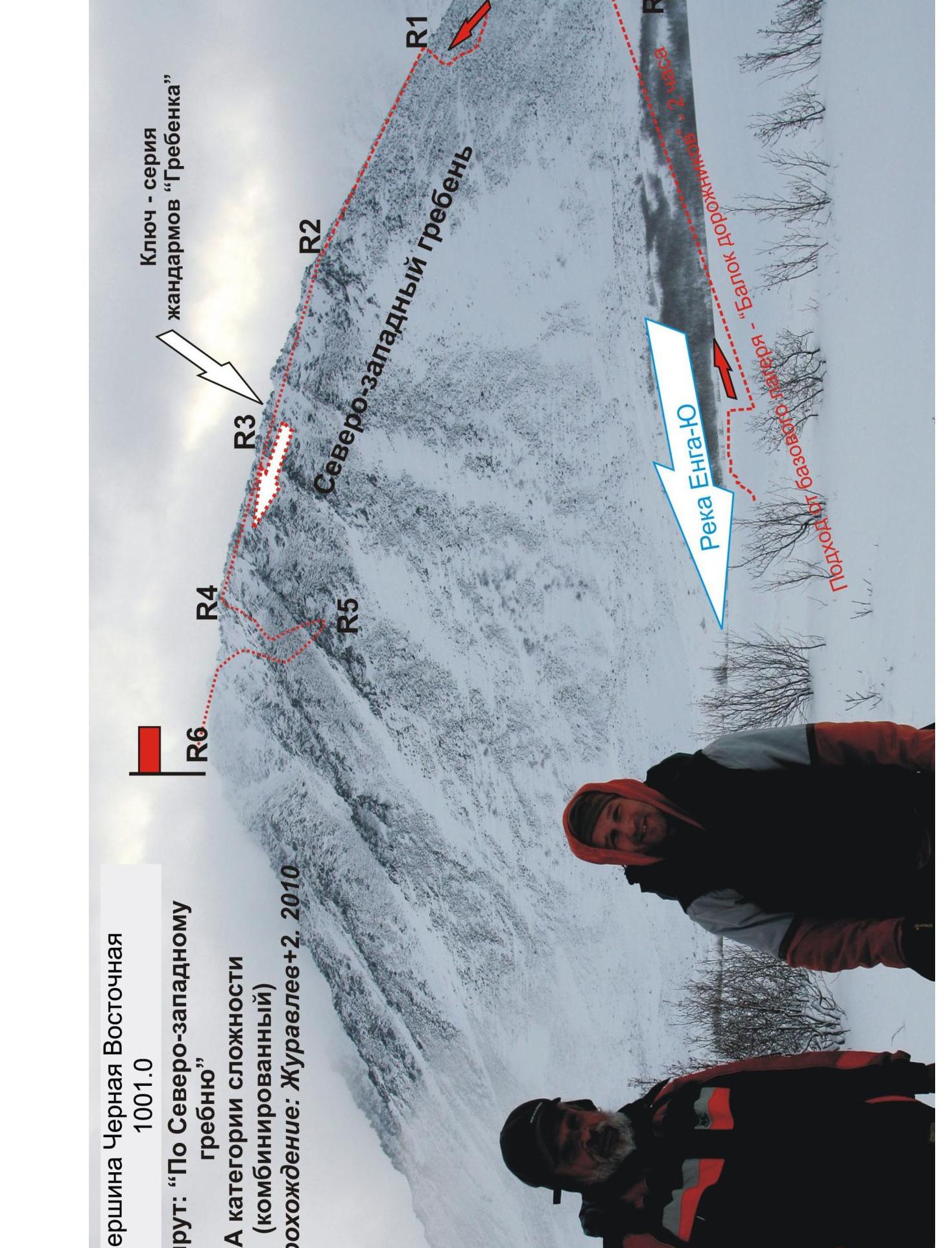
Key section — series of gendarmes
"Grebënka"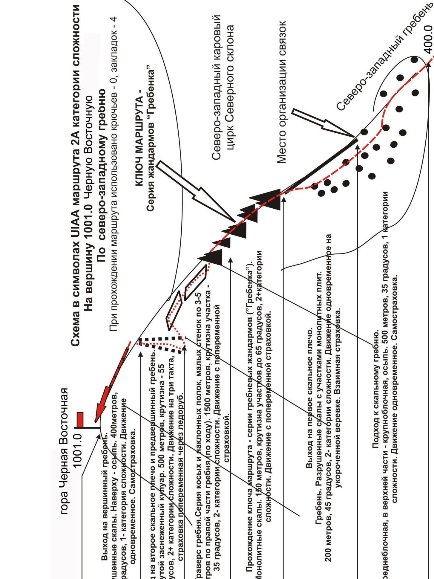
Start of the route at the foot of the NW
ridge.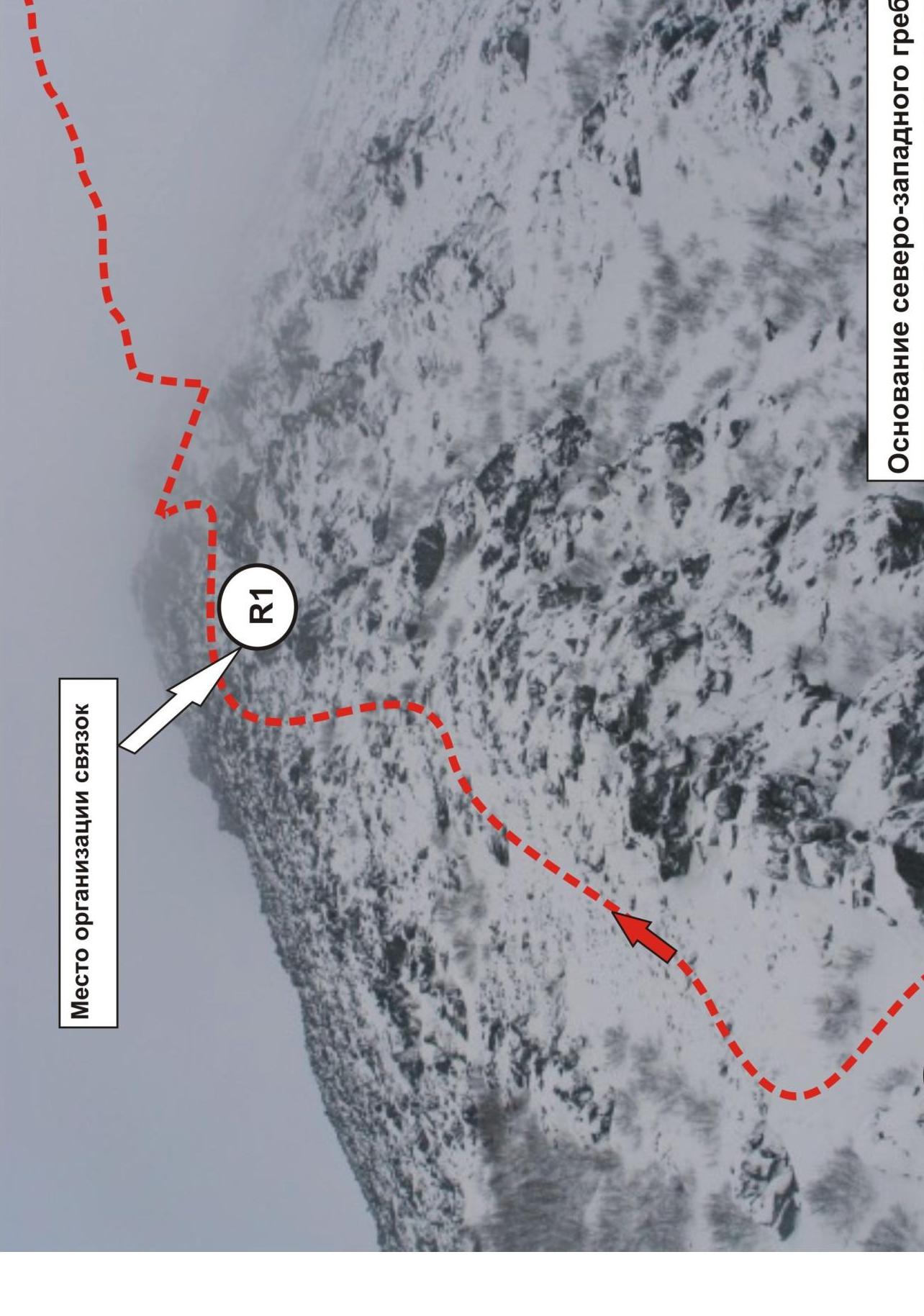 □
□
Summit 1001.0 (Chyornyaya Vostochnaya)
| R6 | 1001.0 |
|---|
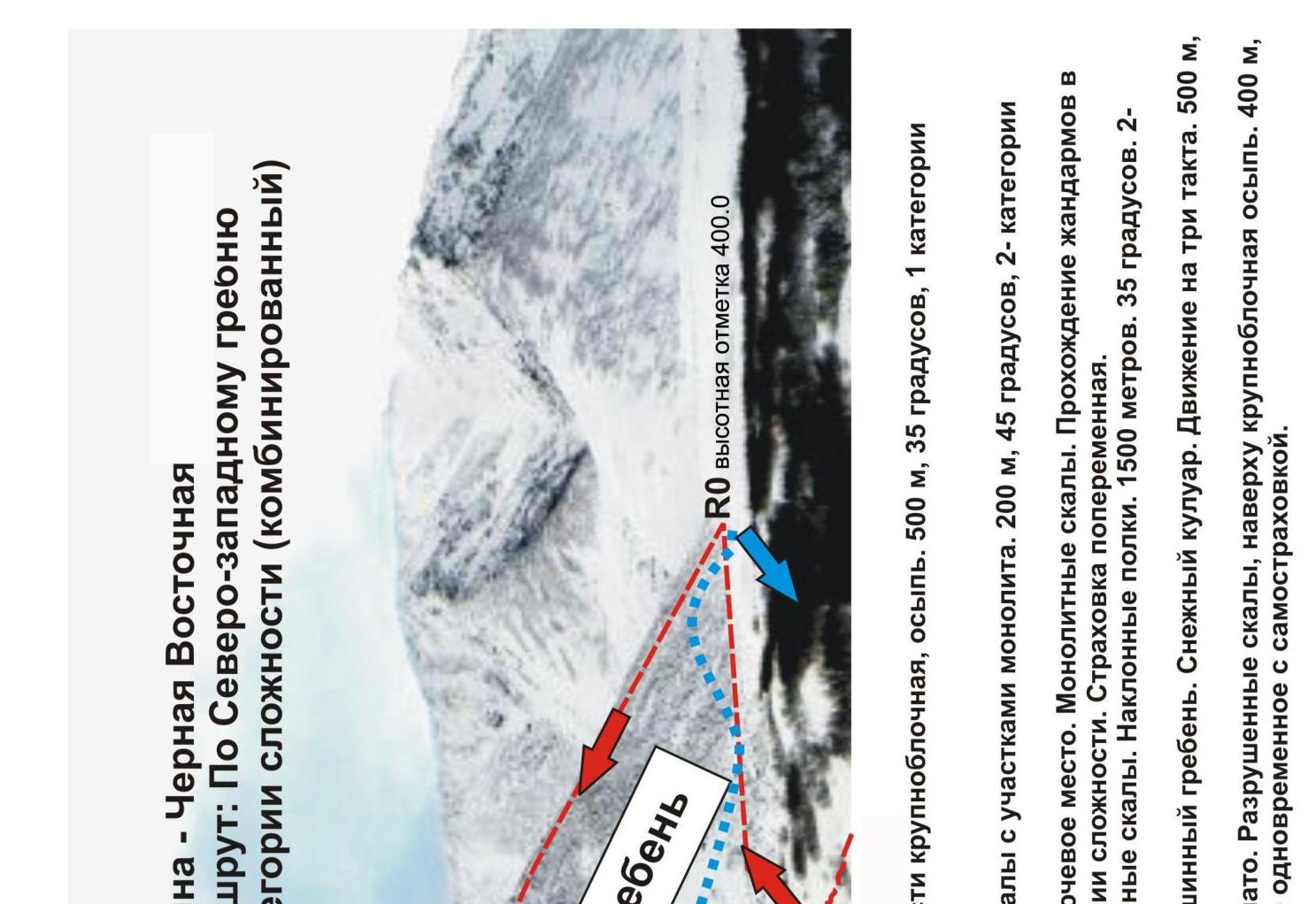
R0 — start of the route at the foot of the Chyornyaya mountain.
R0–R1 — ascent via the talus slope. Medium-block, in the upper part large-block, osyp'. 500 m, 35°, 1 category of aesthetics. Simultaneous movement with self-belaying.
R1 — location for organizing rope teams, start of the rock ridge.
R1–R2 — exit onto the first rock shoulder. Ridge. Destroyed rocks with sections of monolith. 200 m, 45°, 2 category of aesthetics. Simultaneous movement on a shortened rope.
R2–R3 — passage of a series of ridge gendarmes ("Grebënka"). Key location. Monolithic rocks. Passage of gendarmes in reverse on the right. 150 m, sections up to 65°. 2B category of difficulty. Alternating belay.
R3–R4 — traverse of the ridge along a series of ledges on the right slope. Destroyed rocks. Inclined ledges. 1500 m, 35°. 3 category of difficulty. Alternating belay.
R4–R5 — approach to the middle part of the couloir. Exit via the couloir to the summit ridge. Snowy couloir. Movement in three pitches. 500 m, 50°, 2B category of difficulty. Alternating belay.
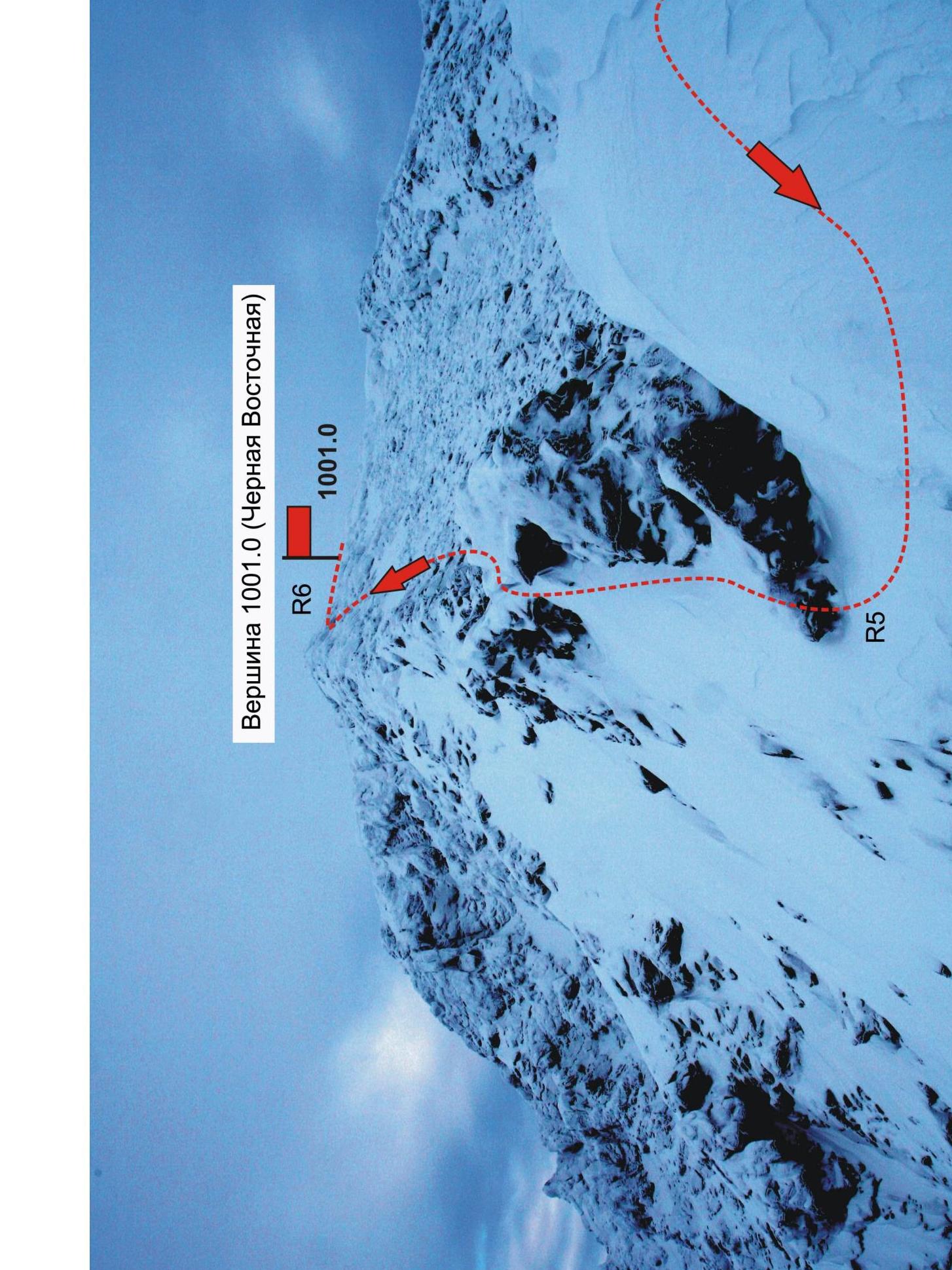
R5–R6 — passage of the summit ridge and exit onto the summit plateau. Destroyed rocks, at the top large-block talus. 400 m, easy, 1 category of difficulty. At the top — non-category. Simultaneous movement with self-belaying.
R6 — summit 1001.0. Plateau-like. No triangulation point.
Comments
Sign in to leave a comment