Passport
- Section number according to KMGV — 2010 — 8.3.61
Polar Urals, Raiiz mountain massif, valleys of the Enga-Yu and Sob rivers.
- Name of the peak: 1287.0 (Topografov Peak)
height: 1287.0 route: north-eastern ridge.
- Category of complexity: 1B, pp.
- Character of the route — combined.
- Height difference of the route: 520 m
- Length of the route: 5900 m
- Length of sections with the highest category of complexity:
1st category — 1 section — 1500 m, 2nd category — 1 section — 2000 m,
3-0 m, 4-0 m, 5-0 m, 6-0 m.
- Average steepness: main part of the route — 50 degrees.
whole route — 45°. 9. Number of pitons used: Total used on the route:
- rock pitons — 0,
- chocks — 0,
- stationary bolt pitons — 0,
- ITO — 0,
- removable bolt pitons — 0. Left on the route: total — 0; including bolt pitons — 0.
- Departure on the route — 6:00, August 5, 2006
Reached the summit — 11:30, August 5, 2006. Returned to the base camp — 18:00, August 5, 2006
-
Team's walking hours: — 12 hours.
-
Leader: Goletarov Andrey Mikhailovich (2nd sports category, Inta). Participants: L. Kaneva (3rd sports category, Syktyvkar), E. Burtsev (3rd sports category, Syktyvkar), K. Tolstikov (3rd sports category, Syktyvkar).
-
Coach: Zhuravlev Sergey Vasilievich, title — CMS, 1st category instructor-methodologist.
Description of the peak
Peak 1287 (Topografov Peak) is one of the most interesting peaks for climbers in the Raiiz mountain massif, located in the Yamalo-Nenets National District (YNAO) of the Tyumen region, Ural Federal District of the Russian Federation, on the eastern slopes of the Polar Urals, on the watershed of the mountain valleys of the:
- Sob (west)
- Enga-Yu (south-east)
The peak is a pronounced rocky trapezoid with a flat summit. Height — 1287.0 m. The name is unofficial but has taken root in the tourist-climbing community.
Peak 1287 (Topografov Peak) can be an object for educational and sports ascents, as it has several pronounced rocky ridges.
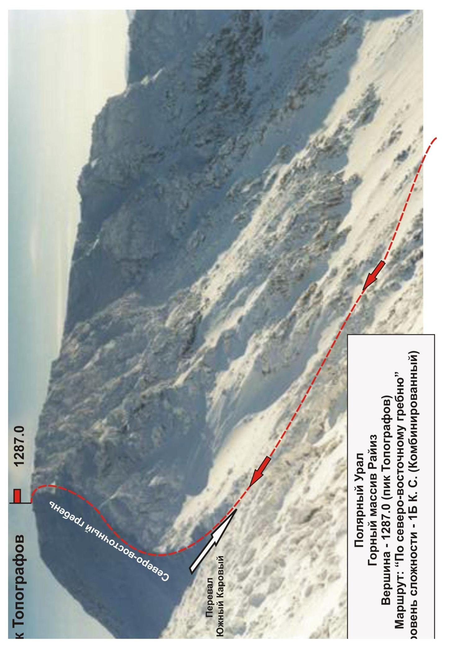
Description of the route: (along the north-eastern ridge) (combined) 1B category of complexity.
Route: "Along the north-eastern ridge (combined)" — a characteristic educational-training route of 1B category of complexity, having a minimal set of natural obstacles. Passing this route has not only aesthetic but also sports-practical significance, as it allows within the ascent:
- to practice insurance and self-insurance techniques on snow-ice relief;
- to practice movement techniques in rope teams along a rocky ridge.
The route is logical in orientation, objectively safe, which allows for educational-sports and sports ascents both in summer and winter.
Equipment
For an ascent as part of an educational-sports group of 6 people (5 participants + instructor) on the route, the following special equipment is necessary:
Personal (standard):
- Crampons — mandatory
- Ice axe — mandatory
Group equipment:
- Main rope 10 mm — 3 pieces of 50 m
- Chock elements — 4 pieces
- Rock pitons — 4 pieces
- Ice screws — 3 pieces
- Quickdraws — 8 pieces
- Loops — 6 pieces
- Rock hammer — 1 piece
- Ice axe — 1 piece
Approach
From the base camp — bivouac "By the lake" — approach the foot of the mountain — the base of the couloir leading to the South Karovyi Pass.
Technical part
Organize rope teams under the pass. Then ascend to the pass (in tourist classification 2A category of complexity). Ascent is simultaneous, but depending on the season: in some years, organization of belays is required when exiting onto the pass.
From the pass along the rocky ridge, exit onto the summit. Insurance is alternating. The summit is a small talus plateau. A cairn is placed in the northern part of the plateau.
The key place of the route is passing the snow-ice (in summer — rocky) ridge leading from the pass to the summit. In winter:
- ice formations,
- snow cornices to the north-east,
- snow drifts "Sugar Head".
Descent from the summit
Descent via the ascent route.
Polar Peak
Polar Urals
Raiiz mountain massif
Peak — 1287.0 (Topografov Peak)
Route: "Along the north-eastern ridge"
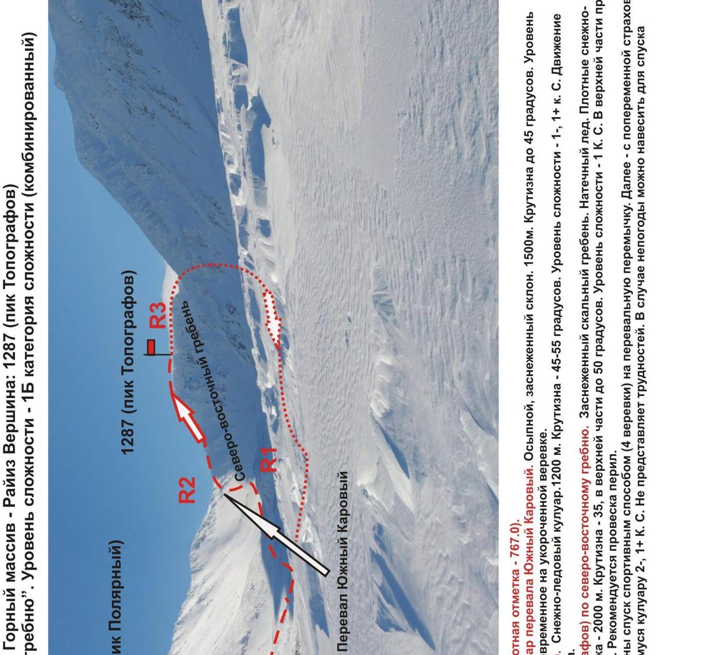
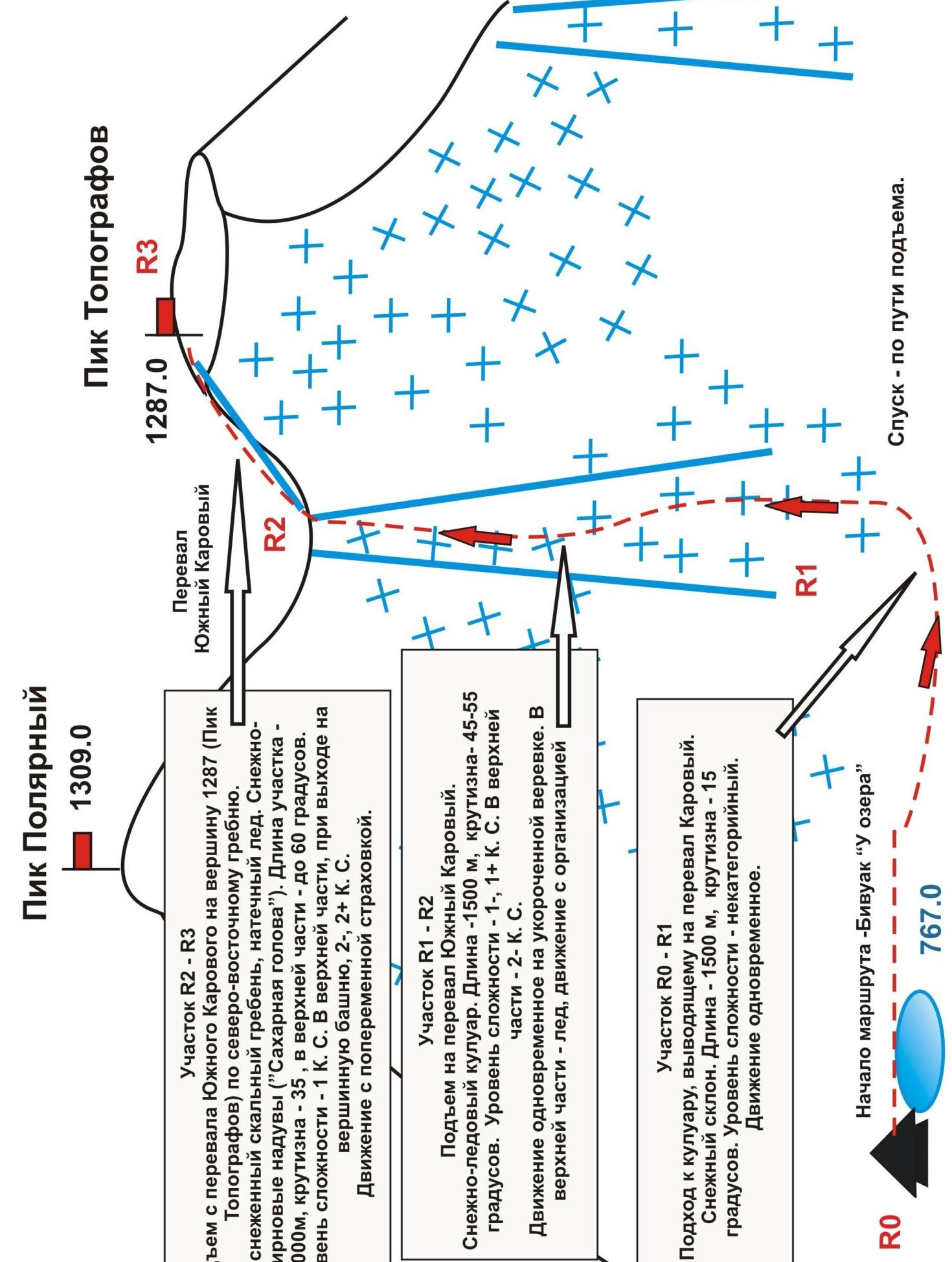
R0 — start of the route. Bivouac "By the lake" (height mark — 767.0). R0–R1 — approach from the bivouac "By the lake" under the couloir of the South Karovyi Pass.
- Talus, snow-covered slope
- Length: 1500 m
- Steepness up to 45°
- Level of complexity of the section — non-categorized
- Movement is simultaneous on a shortened rope
R1–R2 — ascent to the South Karovyi Pass. Snow-ice couloir.
- Length: 1200 m
- Steepness: 45–55°
- Level of complexity: 1-, 1+ category
- Movement is simultaneous, self-insurance with an ice axe
R2–R3 — ascent to peak 1287 (Topografov Peak) along the north-eastern ridge. Snow-covered rocky ridge. Ice formations. Dense snow-ice drifts ("Sugar Head"). Length of the section — 2000 m. Steepness — 35°, in the upper part up to 50°. Level of complexity — 1B category. In the upper part, when ascending to the summit tower — 50 m — 2-, 2+ category. It is recommended to set up belays.
Descent from the summit. From the rocky tower of the summit, descend using sports method (4 ropes) to the pass saddle. Further — with alternating insurance USK into the western kar cirque along a couloir of 2-, 1+ category. Does not present difficulties.
In case of bad weather, it is possible to hang rope belays for descent (6 ropes).


