
Passport
- Section number according to KMGV — 2010 — 8.3.51
Polar Urals, Rai-Iz mountain massif, Nyrdvomen-Shor stream valley
- Name of the peak: 1108.0 (Rai-Iz (Small North))
height: 1108.0 m, route: via the northern ridge.
- Category of complexity: proposed 1Bz, pp
- Character of the route — winter.
- Height difference of the route: 728 m
- Length of the route: 2200 m
- Length of sections with the highest category of difficulty:
1st cat. diff. — 3 sections — 1350 m, 2nd cat. diff. — 2 sections — 850 m, 3 — 0 m, 4 — 0 m, 5 — 0 m, 6 — 0 m.
- Average steepness: main part of the route — 65 degrees.
entire route — 50 degrees.
9. Pitons used:
Total used on the route:
- rock pitons — 0
- chocks — 0
- stationary bolt pitons — 0
- ITO — 0
- removable bolt pitons — 0
Left on the route: total — 0; including bolt pitons — 0.
- Departure to the route — 6:00, March 6, 2011
Reached the summit — 12:15, March 6, 2011. Returned to the base camp — 16:00, March 6, 2011
- Team's walking hours: — 11 hours.
- Leader: Toropov Vladimir Alexandrovich (1st sports category, Syktyvkar).
Team members:
- Yu. Bykhovtsova (3rd sports category, Syktyvkar)
- O. Moiseeva (3rd sports category, Syktyvkar)
- A. Seleznev (3rd sports category, Ukhta)
- A. Golovnya (3rd sports category, Ukhta)
- P. Meldzhis (3rd sports category, Syktyvkar)
- A. Korobov (3rd sports category, Belgorod)
- Coach: Zhuravlev Sergey Vasilyevich, title — CMS, 1st category instructor-methodologist.
Description of the peak
Rai-Iz (Small North) peak is located in the Yamalo-Nenets Autonomous Okrug (YNAO) of the Tyumen Oblast, Ural Federal District of the Russian Federation, 30 km southeast of the 110 km halt (formerly the settlement of Polar), in the valley of the Nyrdvomen-Shor stream (a large right-bank tributary of the Sob River), on the eastern slopes of the Polar Urals, and is the northernmost peak of the Rai-Iz table mountain. The peak is dome-shaped, with a height of 1108.0 m.
Rai-Iz (Small North) peak can be an object for educational and sports ascents, as it has:
- a number of pronounced rock ridges,
- corrie ridges on the northern slope,
- a northwest ridge.
The name of the mountain is official and appears on maps of the Polar Urals; the orographic clarification of the peak (Small North) is given for the convenience of orientation for climbers, since the main Rai-Iz peak (1097 m) is a table mountain with a vast summit plateau (about 26 km in diameter) that is lower than Rai-Iz North and Rai-Iz Small North.
Description of the route: "via the northern ridge" (winter).
Route: "Via the northern ridge (winter)" — a typical winter educational and training route of 1B category of difficulty, having a minimal set of natural obstacles.
Completing this route has not only aesthetic but also practical and sports significance, as it allows for the development of skills within the ascent:
- belaying
- self-belaying on snow and ice terrain
The route is logical in orientation, objectively safe, which allows for educational and sports ascents in winter.
Equipment
For an ascent as part of an educational and sports group of 6 people (5 participants + instructor), the following special equipment is necessary on the route:
Personal (mandatory):
- standard
- crampons
- ice axe
Group equipment:
- main rope 10 mm — 3 pieces, 50 m each
- chock stones — 4 pieces
- rock pitons — 4 pieces
- ice screws — 3 pieces
- quickdraws — 8 pieces
- slings — 6 pieces
- rock hammer — 1 piece
Ice axe — 1 piece.
From the base camp — "Geologists' Barracks 'Nefritovy Stream'" — proceed along the snowy slope to the rock-island at the beginning of the couloir. On the rock, there is a convenient place to organize teams.
Technical part
Initially, from the rock-island (team organization point), ascend the couloir (left branch) to the lowering in the ridge (saddle). Then, upwards along the talus slope, bypassing a large rock remnant on the left. Further along the snowy talus ridge, approach the key point of the route — a steep snowy ascent leading to the pre-summit shoulder.
Key point of the route: a snow-ice slope 50 m long, with a steepness of 40–65°, in the upper part — a characteristic winter drift with a steepness of 70–80°.
Further, the ridge levels out and does not present technical difficulties until the exit to the dome-shaped summit. A cairn with a note was established by the first ascenders at the junction of the northern ridge with the summit.
Descent from the summit
Descent via the ascent route.
R2–R3 — Ascent along the rocky ridge. Destroyed rocky ridge. Length 200 m. Steepness — 35°. Category of difficulty — 1 — , 1+ . Simultaneous movement on a shortened rope. Pitons used — 0, chocks — 0.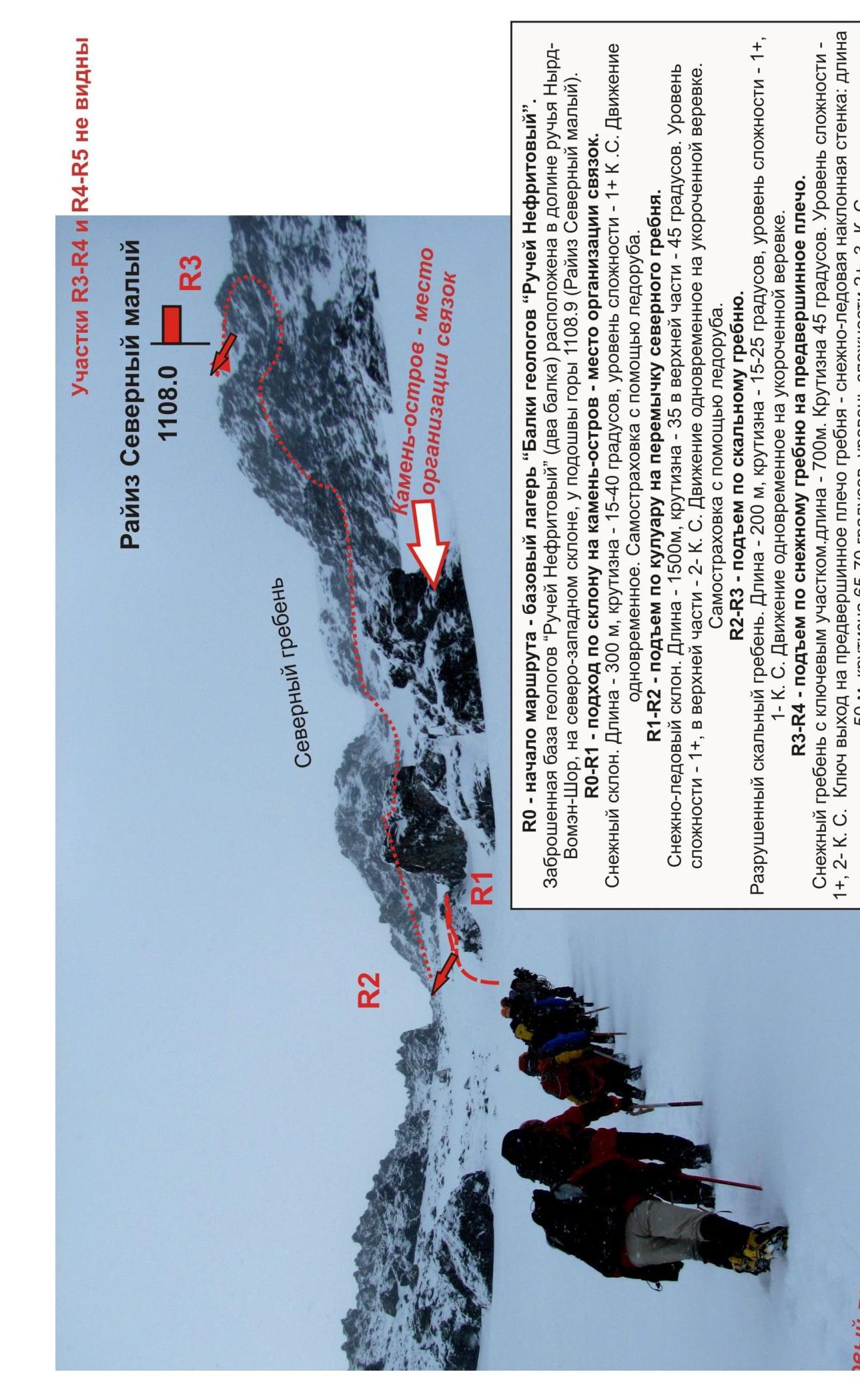
Rai-Iz Small North 1108.0 R3 R2 R1 R0 — start of the route — base camp
Geologists' Barracks 'Nefritovy Stream'. The abandoned geologists' base 'Nefritovy Stream' (two barracks) is located in the valley of the Nyrd-Vomen-Shor streams, on the northwest slope, at the foot of the mountain 1108.9 m (Rai-Iz Small North).
-
R0–R1 — approach along the slope to the rock-island — team organization point. Snowy slope. Length — 300 m, steepness — 15–40 °, category of difficulty — 1B. Simultaneous movement. Self-belaying with an ice axe.
-
R1–R2 — ascent along the couloir to the saddle of the northern ridge. Snow-ice slope. Length — 1500 m, steepness — 35 °, in the upper part — 45 °. Category of difficulty — 1B, in the upper part — 2B. Simultaneous movement on a shortened rope. Self-belaying with an ice axe.
-
R2–R3 — ascent along the rocky ridge. Destroyed rocky ridge. Length — 200 m, steepness — 15–25 degrees, category of difficulty — 1+, 1-B. Simultaneous movement on a shortened rope.
-
R3–R4 — ascent along the snowy ridge to the pre-summit shoulder. Snowy ridge with a key section. Length — 700 m. Steepness — 45°. Category of difficulty — 1+, 2-B. Key point — exit to the pre-summit shoulder of the ridge — a snow-ice inclined wall: length — 50 m, steepness 65–70°, level of difficulty 2+, 3rd category of difficulty. R4–R5 — ascent to the summit along the snowy ridge. Snowy ridge. 500 m. 15–25°. Non-categorical. Simultaneous movement on a shortened rope. Self-belaying with an ice axe. R5 — summit 1108.0 (Rai-Iz Small North). The summit is dome-shaped with a talus plateau on top. Cairn at the junction of the northern ridge with the summit plateau.
Section R3–R4.
Descent from the pre-summit shoulder
at the key point.
Comments
Sign in to leave a comment