Passport
- Section number according to KMGV — 2010 — 8.3.46
Polar Urals, Raiiz mountain massif, valleys of the Nyrdvomen-Shor — Enga-Yu rivers.
- Name of the peak: 1309.0 (Pik Polyarný)
height: 1309.0 route: via the north-eastern ridge.
- Category of difficulty: proposed 2A, pp.
- Character of the route — combined.
- Height difference of the route: 800 m
- Length of the route: 5800 m
- Length of sections with the highest category of difficulty:
R1–R4: 4000 m, R5: 1800 m, R6: 0 m, R7: 0 m, R8: 0 m, R9: 0 m.
- Average steepness: main part of the route — 50 degrees.
entire route — 45 degrees.
9. Pitons used:
Total pitons used on the route:
- rock pitons — 0
- chocks — 0
- stationary bolt pitons — 0
- ITO — 0
- removable bolt pitons — 0
Pitons left on the route: total — 0; including bolt pitons — 0.
- Winter variant: departure onto the route — 7:00, March 1, 2006. Reaching the summit — 15:30, March 1, 2006. Return to base camp — 21:00, March 1, 2006.
Summer variant: departure onto the route — 7:00, July 3, 2007. Reaching the summit — 15:30, July 3, 2007. Return to base camp — 19:00, July 3, 2007.
- Team's walking hours: winter variant — 14 hours, summer variant — 12 hours.
- Winter variant: Leader: Goletarov Andrey Mikhaylovich (2nd sports category, Inta). Participants: L. Kaneva (3rd sports category, Syktyvkar), E. Burtsev (3rd sports category, Syktyvkar), K. Tolstikov (3rd sports category, Syktyvkar).
Summer variant: Leader: Sovenko Leonid Nikolayevich (2nd sports category, Nikolayev). Participants:
- Tikhomirova L. (3rd sports category, Syktyvkar)
- Doroshenko S. (3rd sports category, Syktyvkar)
- Kurbatov R. (3rd sports category, Syktyvkar)
- Coach: Zhuravlev Sergey Vasilyevich, title — CMS, instructor-methodologist 1st category.
Description of the Peak
Peak 1309 (Pik Polyarný) — one of the peaks in the Raiiz mountain massif, located in the Yamalo-Nenets Autonomous Okrug (YaNAO), Tyumen Oblast, Ural Federal District, Russian Federation, on the eastern slopes of the Polar Urals, on the watershed of the mountain valleys of the:
- Nyrdvomen-Shor (north),
- Sob' (west),
- Enga-Yu (south-east).
The peak is a pronounced rock pyramid, height — 1309.0 m. The name is unofficial but has taken root in the tourist-alpinist community.
Peak 1309 (Pik Polyarný) — can be an object for training and sports ascents, as it has several pronounced rock ridges.
Description of the Route: (via the North-Eastern Ridge)
Route: (via the north-eastern ridge, 2A category of difficulty (combined)) — a characteristic training route of the second category of difficulty, with a full set of natural obstacles corresponding to routes of this level of difficulty.
Passing this route has not only aesthetic but also sports-practical significance, as it allows working out belaying and self-belaying techniques on rock and snow-ice terrain within the ascent.
The route is ridge-like, objectively safe in the summer period, which allows conducting training and sports ascents.
Equipment
For an ascent in the composition of a training and sports group of 6 people (5 participants + instructor) on the route, the following special equipment is necessary:
Personal (mandatory):
- climbing harness
- crampons
- ice axe
Group:
- main rope 10 mm — 3×50 m
- rock hammer — 1 piece
- rock pitons — 6 pieces
- ice axe — 1 piece
- chock elements — 6 pieces
- ice screws — 3 pieces
- quickdraws — 6 pieces
- slings — 8 pieces.
Approach
From the base camp — "Nefritovy Brook" (two abandoned geological cabins in the upper reaches of the Nyrdvomen-Shor River) approach the "Vorota" canyon. The "Vorota" canyon is the entrance to a cirque with lakes and snowfields feeding the Nyrdvomen-Shor River.
Technical Part
Pass through the "Vorota" canyon, then, traversing the eastern slope of peak 1213, approach the beginning of a snow-ice couloir leading to the Grandiozny Pass (in tourist classification — 2B winter). At the beginning of the couloir, it is recommended to organize rope teams.
Further:
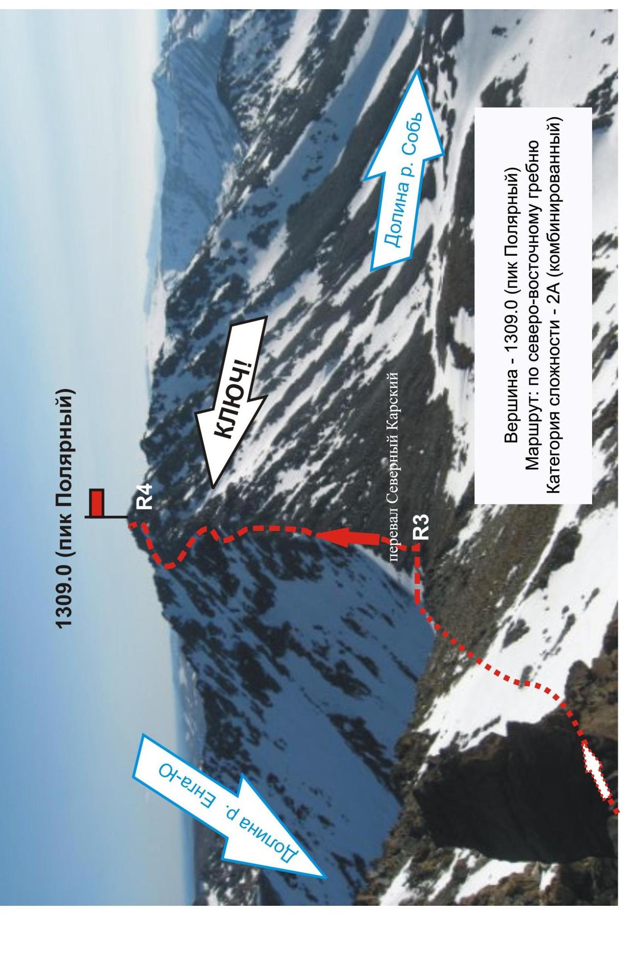
- Ascend the steep snow-ice couloir to the Grandiozny Pass.
- Traverse along the terrace of the south-eastern slope of peak 1213 to the saddle between peaks 1213 and 1309 (Severny Karovy Pass, in tourist classification — 2A winter).
Key Section of the Route
Pronounced rock ridge. In the summer, with strong winds from the Kara Sea, due to the climatic conditions of the Transpolar region, the rocks can be covered with a dense snow-ice accretion up to 70 cm thick or multi-centimeter rime, so the route becomes a pronounced ice route even in summer. However, more often in summer, it is a ridge composed of rock blocks 5 to 10 m high with a huge variety of rock relief. The ascent is even, with alternate belays.
Descent from the Summit
Descent via the ascent route. In case of bad weather, a variant of descent via the south-eastern ridge (route 1B category of difficulty) into the Sob' River valley is possible. In this case, the group descending into the Sob' River valley will have a safe but long transition (more than 20 km) through the mountain tundra, bypassing the north-western slopes of the Raiiz mountain massif.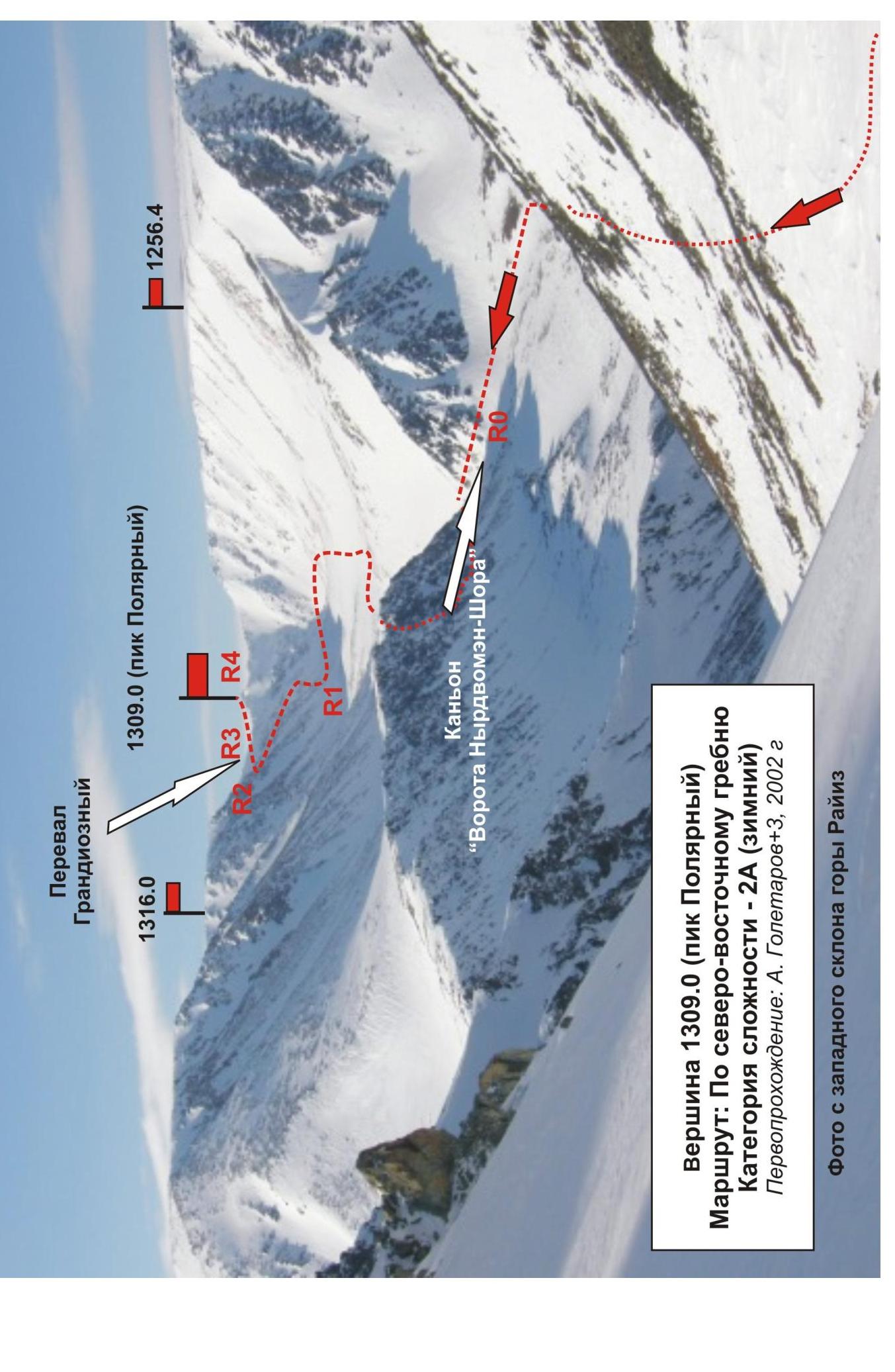
1309.0 (Pik Polyarný) — 1256.4 —
1309.0 (Pik Polyarný)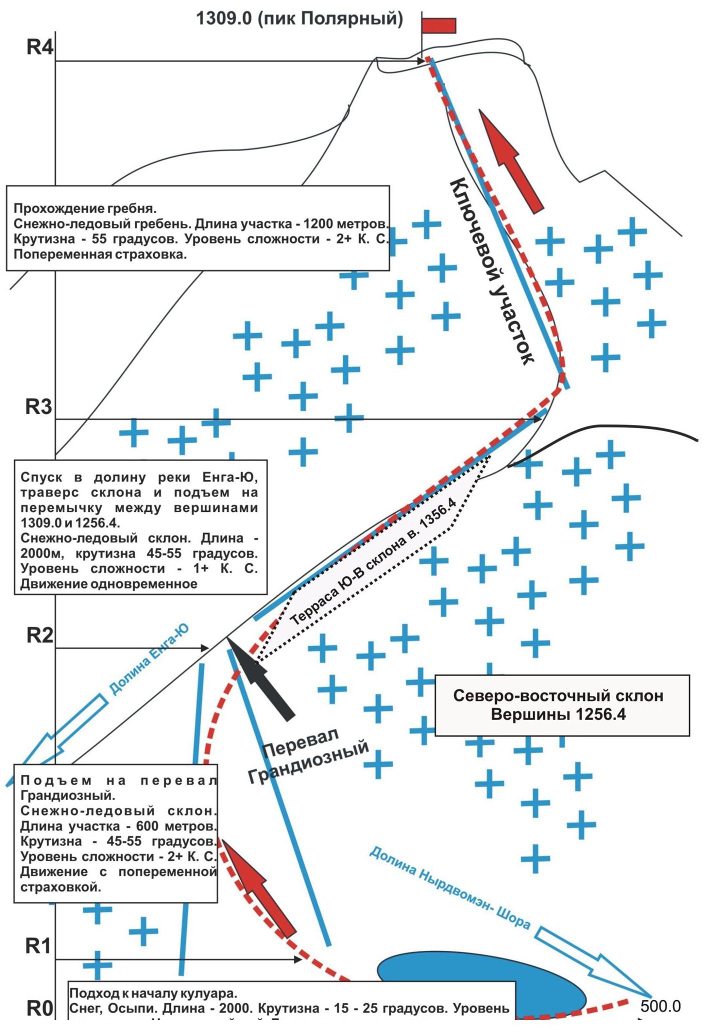
15 — 25
degrees. Level
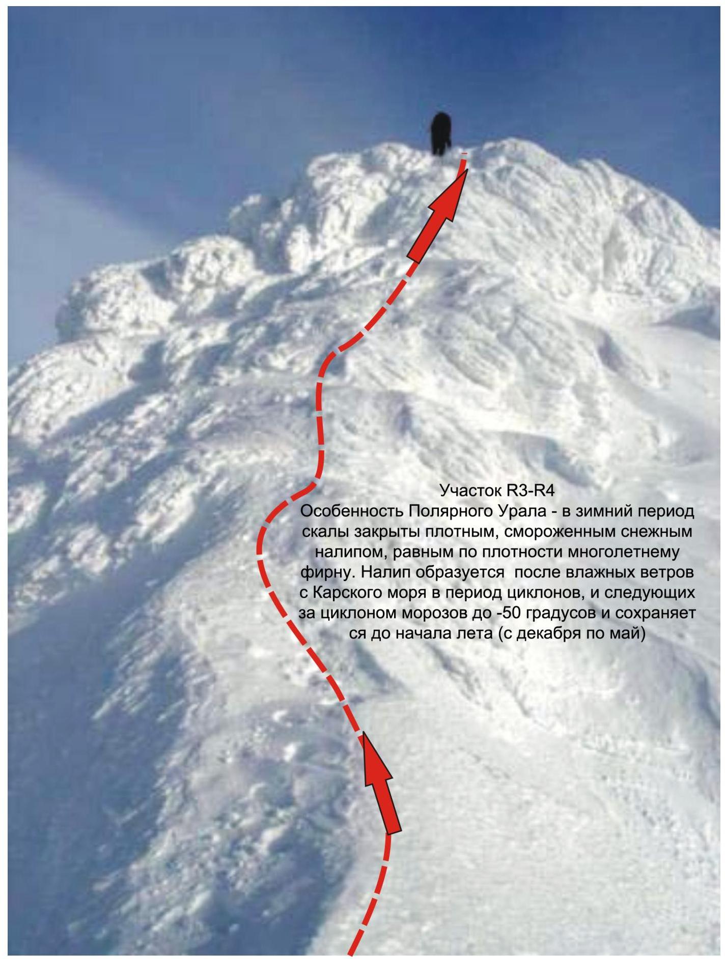
Section R3–R4
A feature of the Polar Urals — in the winter period, the rocks are covered with dense, frozen snow
Footnotes
-
Approach to the beginning of the couloir. R0. Snow, scree. Length — 2000 m. Steepness — ↩