Ascent Passport
Region — Subpolar Urals. Ridge — Narod-Ityinsky Ridge (kряж). Gorge — Bolshaya Lemva River Valley. Mountain Massif — Parnokaiz. Section number according to KMGV-2001 — #8. "Other mountain systems, massifs". Peak name — 1020 (Parnokaiz Western). Height — 1020 m. Route name — via the western ridge. First ascent. Proposed difficulty category — 1B cat. sl. (rocky). Note: The Alpinism Federation of the Komi Republic requests the classification commission of the Alpinism Federation of Russia to credit the group of pioneers for the ascent of 2A cat. sl.
Elevation gain — 810 m, route length — 2 km, average steepness of the main (technical part) of the route — 45°, average steepness of the entire route — 35°.
Sections of 3, 4, 5, and 6 cat. sl. — none, no pitons left on the route.
Time taken by the team for the ascent:
- Approach to the base camp (mothballed geologists' base "Lemva") from the miners' settlement Pachvoz — 2 days.
- Ascent from the base camp (mothballed geologists' base "Lemva") — 8 hours.
The ascent was made by a sports group consisting of:
- Leader — com. otr. NP-2: S. V. Zhuravlev (CMS, instr. 2 cat., cert. #1124, Syktyvkar).
Participants:
- Kustov P. A. ("Alpinist of Russia" badge, Syktyvkar)
- Punanova A. A. ("Alpinist of Russia" badge, Syktyvkar)
- Druzhinin E. V. ("Alpinist of Russia" badge, Syktyvkar)
- Repina S. A. ("Alpinist of Russia" badge, Syktyvkar)
- Chernetsova M. V. ("Alpinist of Russia" badge, Syktyvkar)
- Klementyev D. N. ("Alpinist of Russia" badge, Syktyvkar)
- Koldanova T. M. ("Alpinist of Russia" badge, Syktyvkar)
- Bobretsov K. L. ("Alpinist of Russia" badge, Ukhta)
Coach — Zhuravlev Sergey Vasilyevich (CMS, instr. 2 cat., cert. #1124, Syktyvkar).
Senior coach-supervisor — Fomenko Felix Nikolayevich (CMS, instr. 1 cat., cert. #7, Ukhta).
Departure for the route — 6:00, August 6, 2005. Reaching the summit — 11:00, August 6, 2005. Return to base camp — 14:00, August 6, 2005. Alpinist event: Monitoring expedition of the Alpinism Federation of the Komi Republic "Lemva-2005".
Organizers of the expedition:
- Alpinism Federation of the Komi Republic
- Non-commercial partnership "Club of Northern Travels — Sauk-Pai"
- Club of tourists and alpinists of Ukhta
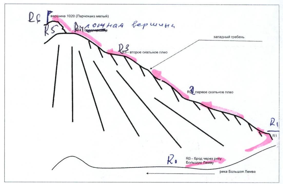
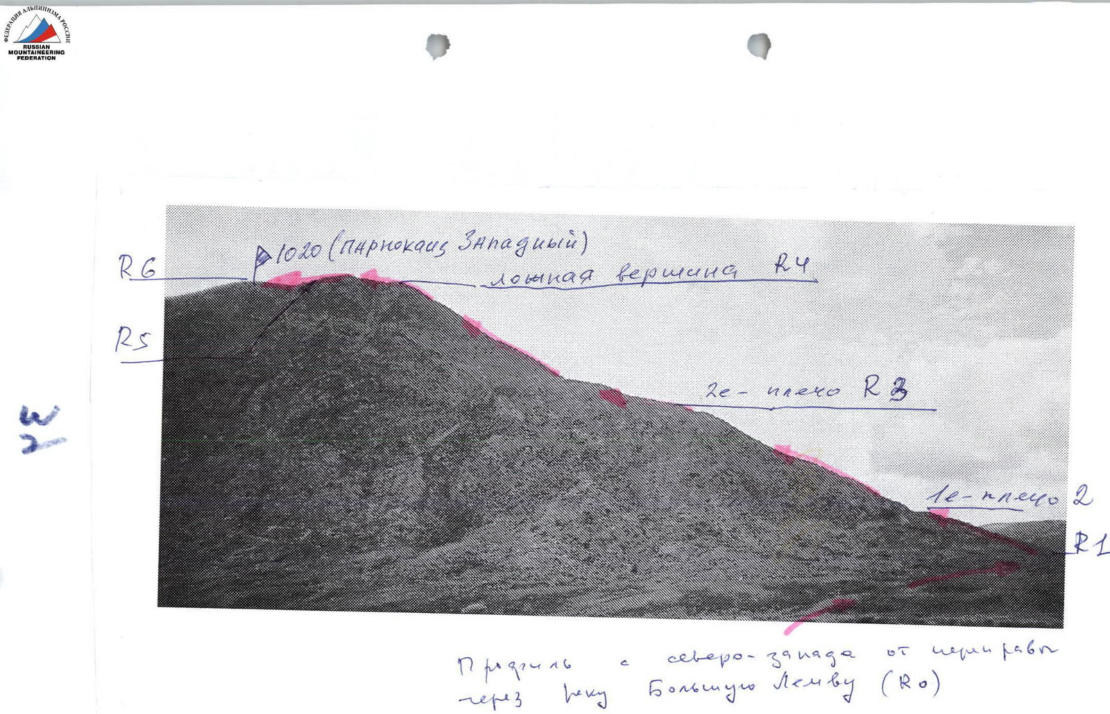 Profile from the northwest from the crossing of the Bolshaya Lemva River (R0).
Alpinism Federation of the Komi Republic NP "Club of Northern Travels Sauk-Pai" Club of tourists and alpinists of Ukhta
Report on the First Ascent
Mountain region: Subpolar Urals. Gorge: Bolshaya Lemva River valley. Ridge: Narod-Ityinsky Ridge (kряж). Mountain massif: Parnokaiz. Peak: 1020 (Parnokaiz Western). Route: via the western ridge. Proposed difficulty category for inclusion in the KMGV of the Alpinism Federation of Russia: 1B cat. sl. (rocky). (The group that made the first ascent is proposed to be credited for the ascent of 2A cat. sl.).
Leader: Zhuravlev S. V. Date of the ascent: August 6, 2005. Alpinist event: Monitoring expedition "Lemva-2005" of the Alpinism Federation of the Komi Republic.
Senior Coach-Supervisor
Alpinism Federation of the Komi Republic:
- Fomenko F. N. (CMS, instr. 1 cat., cert. #7, Ukhta)
- Zhuravlev S. V. (CMS, instr. 2 cat., cert. #1124, badge #6190, Syktyvkar) — deputy for safety (nachspas)
Report prepared by: expedition leader Zhuravlev Sergey Vasilyevich.
Address: 167000, Syktyvkar, ul. Internatsionalnaya, d. 97, kv. 12. Phone: (8212) 24-24-91 (home). E-mail: zhur58@rambler.ru
Syktyvkar, 2006.
 View of peak 1020 (Parnokaiz Western) from the south.
 Peak 1020 (Parnokaiz Western), western ridge. Route: via the western ridge 1B cat. sl. (rocky). View from peak 1245 (Makara Babikov mountain).
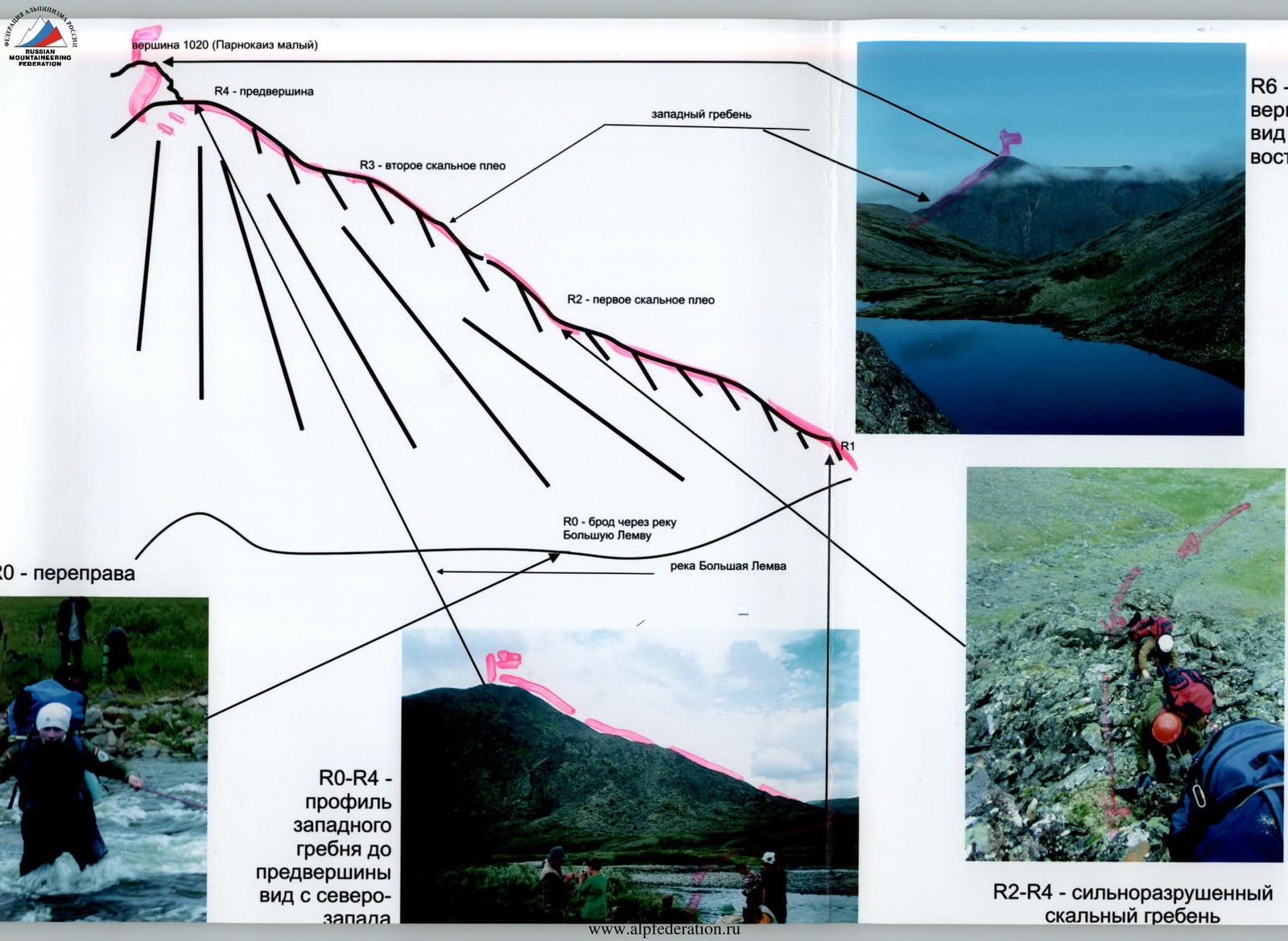 R2–R4 — severely destroyed rocky ridge.
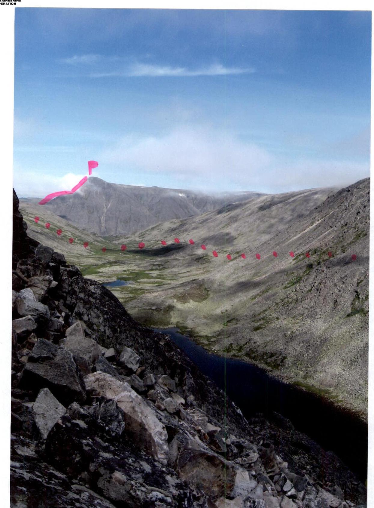
 R0–R4 — profile of the western ridge to the sub-summit, view from the northwest.
Map-scheme (not to scale) approximately: 1 cm — 500 m. Approach to peak 1020 from the base camp.
Description of the Peak
Peak 1020 (Parnokaiz Western) is the westernmost peak of the Parnokaiz mountain massif, which divides the valleys of the Bolshaya Lemva River (to the southwest) and the Parnokayu River (to the northeast). The mountain massif is located west of the Main Watershed Ridge of the Subpolar Urals (section from peak Lemvaiz to peak Khaimaiz). Parnokaiz is a severely destroyed mountain massif with a vast summit plateau and several independent peaks located in various parts of the summit plateau. Peak 1020 (Parnokaiz Western) is the westernmost of the peaks of the Parnoksky mountain massif, having potential objects for sports ascents — i.e., routes. The most logical of these is via the western ridge. The peak is clearly defined and has an independent geodetic mark on the map of the Subpolar Urals. The peak does not have an independent name. The local name for the peak is unknown. This peak was named Parnokaiz Western by the participants of the monitoring expedition — alpinist-pioneers — for the convenience of orientation of sports groups of alpinists.
Description of the Route
Approaches. First option: from the miners' settlement Pachvoz, walk along the dirt road to the reindeer herders' camp on the Kuzel stream. Then cross into the Bolshaya Lemva River valley via a non-category pass located to the left (in the direction of travel) of peak Chikam. The pass is accessible via a dirt road. Then descend along the dirt road to the Bolshaya Lemva River. The Bolshaya Lemva River makes a long loop, which is cut off by the dirt road. As a result of this shortcut, participants and organizers of the ascent have to cross the river twice. "The fords are deep. The current is fast. For participants of initial level of preparation, organization of rope belays is required." Behind the second ford is the last willow tundra oasis, where it is possible to prepare food and dry clothes with the help of a bonfire. It is also possible to set up a temporary bivouac on the talus terraces at the foot of the western ridge. Not far from the second ford is the starting point of the route to peak 1020 (Parnokaiz Western) via the western ridge. Second option: in case of locating the base camp of the alpinist event in the area of the mothballed geologists' base "Lemva", one should exit along the dirt road downstream along the river valley, then cross the Pernashor stream and again go along the dirt road to the crossing of the Bolshaya Lemva River. From the crossing begins the technical part of the route.
Technical part: the route is a clearly defined rocky- talus ridge, consisting of several characteristic sections. It is convenient to form a rope team at the base of the first rocky shoulder. Then, along inclined rocky slabs, ridge sections, and small internal corners of equal difficulty, ascend to the first rocky shoulder of peak 1020 (Parnokaiz Western). Then, along a well-defined rocky ridge, reach the second shoulder. After that, the rocky sections gradually become gentler and lead to the sub-summit. On all sections up to the sub-summit, movement is simultaneous, on a shortened rope, with the organization of belays by looping the rope around large stone blocks or rocky outcrops on the ridge. After the sub-summit, the ridge smoothly transitions into the summit plateau of the Parnokaiz massif with a weakly defined talus ridge leading to the talus dome of peak 1020 (Parnokaiz Western). The summit is a clearly defined talus dome composed of large natural fragments. The ascent to the summit dome is not complicated.
Descent: via the ascent route.
Equipment for a beginner training group of 10 people:
- Climbing rope main 10 mm — 3 × 50 pcs.
- Carabiners — 5 pcs.
- Station loops — 3 pcs.
- Rock pitons — 3 pcs.
- Rock hammer — 1 pc.
- Primus (gas burner) — 1 pc.
- Pot — 1 pc.
 Map-scheme of the mountain route. Organization and auxiliary means.
 Map-scheme of the mountain ridges of the Parnokaiz mountain massif (not to scale) — approaches and ascent route.
R0 — crossing of the Bolshaya Lemva River.
R0–R1 — ascent to the base of the first rocky shoulder of the western ridge to the location of the rope team.
Section characteristics — mountain tundra, large-block talus, kurumniks. Section length — 300 m. Average steepness — 15°. Difficulty level — non-category.
R1–R2 — ascent to the first rocky shoulder of the western ridge. Section characteristics — severely destroyed rocky ridge: inclined slabs, oblique shelves, small internal corners. Section length — 700 m. Average steepness — 25°. In some areas — 45°. Difficulty level — 1 cat. sl. Movement is simultaneous, on a shortened rope, with belays by looping the rope around outcrops and large rocky blocks.
R2–R3 — ascent to the second rocky shoulder. Section characteristics — severely destroyed rocky ridge: inclined slabs, oblique shelves, small internal corners, with narrowing in the upper part — a jagged rocky ridge of dense rocks. Section length — 600 m. Average steepness — 45°. In some areas — 55–60°. Difficulty level — 1+, 1- cat. sl. In some places of the upper part of the ridge, short sections of 3–4 m — 2 cat. sl. Movement is simultaneous, on a shortened rope, with belays by looping the rope around outcrops and large rocky blocks.
R3–R4 — ascent to the sub-summit. Section characteristics — severely destroyed rocky ridge: inclined slabs, oblique shelves, small internal corners, with narrowing in the upper part — a jagged rocky ridge of dense rocks. Section length — 650 m. Average steepness — 45°. In some areas — 55–60°. Difficulty level — 1+, 1- cat. sl. In some places of the upper part of the ridge, short sections of 3–4 m — 2 cat. sl.
Movement is simultaneous, on a shortened rope, with belays by looping the rope around outcrops and large rocky blocks.
R4–R5 — transition along the summit plateau of the Parnokaiz mountain massif to the base of the talus dome of peak 1020 (Parnokaiz Western).
Section characteristics — mountain tundra, large-block talus, kurumniks. Section length — 2000 m. Average steepness — 15°. Difficulty level — non-category.
R5–R6 — ascent to the summit talus dome. Section characteristics — large-block talus. Section length — 300 m. Average steepness — 25°. Difficulty level — 1 cat. sl.
R6 — peak 1020 (Parnokaiz Western). R6–R0 — descent via the ascent route.


