Climbing Route Passport
Mountain region — Subpolar Urals Gorge — Balbanyu river valley Ridge — Research Ridge Peak — Erkusei (1099) Route — via the northern wall Difficulty category — 2B cat. grade.

Ascent Passport
Region — Subpolar Urals. Ridge — Research Ridge Gorge — Balbanyu river valley. Section number according to KMGV-2001 No. 8. "Other mountain systems, massifs" Peak name — Erkusei (Shaman-gora) Height — 1099 Route name — via the northern wall First ascent
Note: We ask the classification commission of the FAR to credit the group of pioneers with the ascent of 3A cat. grade. Proposed 2B cat. grade.
Winter ascent
Height difference — 570 m (according to the General Staff map in m: 1 cm – 1 km) Route length — 800 m Average steepness of the main (technical part) of the route — 65° Average steepness of the entire route — 60° Number of pitons left on the route — 2. No drill-in anchors were used.
Team's travel hours:
- Approach to the "Shaman bivouac" from the geologists' base Zhelannaya — 3 hours.
- Ascent from the "Shaman bivouac" — 6 hours.
Team leader: S. Kiselev, 2nd sports category
Team members:
- Yu. Mezenev — 3rd sports category (Inta)
- K. Kharitonov — 3rd sports category (Inta)
- A. Gubin — 3rd sports category (Inta)
- Zhuravlev Sergey Vasilievich, CMS, instructor 2 cat.
Departure for the route 9:00, March 6, 2003. Reached the summit 12:30 March 6, 2003. Return to the base camp — 15:00 March 6, 2003.
Organization:
NP "Federation of Alpinism of the Komi Republic", Correspondence championship of the Komi Republic in alpinism, first ascent class. 2003.
Executed by Zhuravlev Sergey Vasilievich (Syktyvkar), Kiselev Sergey Nikolaevich (Inta) Syktyvkar, 167000, Internatsionalnaya str., 97, apt. 12. Phone: 24–24–91. E-mail: Zhur58@rambler.ru
Releasing coach S. V. Zhuravlev
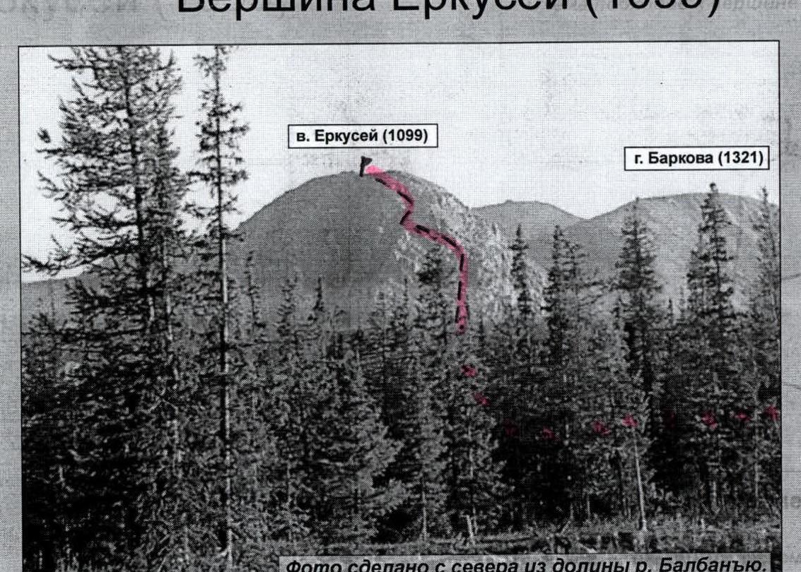
Peak Erkusei (1099)
Description of the peak
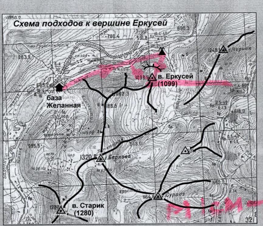
Peak Erkusei is located within 2–3 hours walk from the geologists' base Zhelannaya on the right bank of the Balbanyu river. Height above sea level 1099 m.
The common Russian name for this peak is Shaman-gora, as historically, a shaman of the Ob reindeer herders used to stop at the foot of Erkusei, who traditionally grazed their reindeer herds in the Balbanyu river valley in the summer. To this day, a reindeer herders' yurts stand at the "shamanic" bivouac.
Peak Erkusei has one object for sport climbing — the northern wall, composed of dense dark rocks. The ascent begins from the reindeer herders' bivouac ("Shaman bivouac").
According to unverified data, ritual ascents to the top of Erkusei were made by reindeer herders since ancient times (via the non-categorized northeastern slope) for sacrificial purposes, as Erkusei was considered the abode of the spirit of the North Wind — Voipel. Currently, there are fragments of sleds and reindeer antlers on the summit of Erkusei.
Route description
Approach: from the base camp at the reindeer herders' bivouac ("Shaman bivouac") on the right bank of the Balbanyu river, the approach to the foot of the northern wall is 500 m.
Technical part of the route: From the foot, ascend a snow-covered slope with a steepness of 30°, length 150 m, to rock outcrops. Then traverse inclined ledges with a steepness of 50–80° for 250 m to a vertical wall 4 m high. Bypass the wall on a ledge to the left, circumventing a rock rib (Key to the route!). Then traverse a diagonal ledge to the left — 75 m — and exit to a snow-ice couloir. Enter the couloir in its middle part. Continue up to the next rock outcrops for 300 m. Then ascend inclined slab-like ledges at an angle of up to 40° to a snowy ridge 50 m, leading to the pre-summit plateau.
The summit is plateau-like. The highest point is a pile of debris.
Required special mountaineering equipment for a sports group of 4 people: 2 ropes of 40 m each, rock pitons — 10, expendable slings — 4, quickdraws — 6, carabiners — 15.
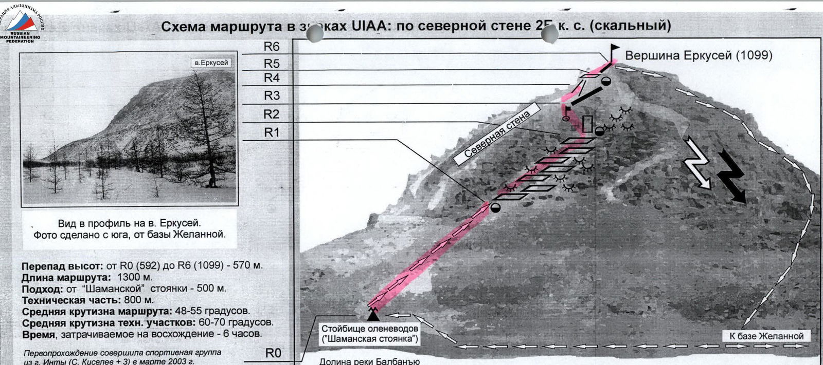
R0 — Reindeer herders' bivouac ("Shaman bivouac").
R0–R1 — Ascend a slope (scree, snow. 150 m. 30°. Easy. Simultaneous movement).
R1–R2 — Traverse a series of diagonal ledges and walls between rock outcrops in the lower part of the wall. (Rock. Section length — 250 m. Average steepness of the rock section 50–70°. Cat. grade: 2, 2. In some areas — 3. Alternating protection, rope team coordination. Intermediate belay anchors — pitons).
R2–R3 — (Key to the route!) Traverse with a bypass of the wall and crossing a protruding rock ridge (Dense, blocky rocks. 100 m. 60–70°. Cat. grade: 3. Alternating protection, rope team coordination. Intermediate belay anchors — pitons).
R3–R4 — Ascend a snow-ice couloir (Ice, firn, snow, scree. 200 m. 40–50°. Cat. grade: 2, 2. Alternating protection).
R4–R5 — Traverse the pre-summit ridge. (Rock. Inclined ledges. 40 m. 40°. Cat. grade: 2). Exit to the pre-summit plateau. (Rock, scree. 500 m. Cat. grade: 2. Simultaneous movement, protection via ridge outcrops).
R5–R6 — Reach the summit. (Scree plateau. Easy).
R6 — Peak Erkusei (1099).
R6–R1 — Descend via the southern ridge and western slope. (Snow, scree. Easy. In winter, the slope is avalanche-prone!)
R1–R0 — Return to the "Shaman bivouac". (Traverse the western slope. Snow, scree. Easy) In winter, the slope is avalanche-prone!
Peak Erkusei (Shaman-gora) (1099)
View of the northern wall (winter).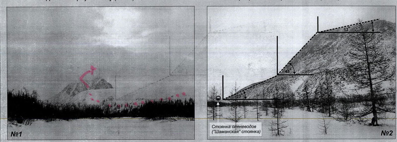
Route to peak Erkusei (1099) via the northern wall 2B cat. grade. Short but technically challenging. Consists of three profile sections:
- Approach from the summer reindeer herders' bivouac ("Shaman bivouac") via scree slopes to the base of the wall (Average steepness of the section — 23°);
- Ascent of the northern wall (Average steepness — 48°. In some technical areas — 55–70°);
- Reach the summit (Average steepness — 13°).
Photo No. 1 taken from the Balbanyu river valley. Photo No. 2 taken from the Balbanyu river valley, from the geologists' base Zhelannaya.