Passport
- Section number according to KMGV — 2010 — 8.3. 11a
Polar Urals, Raiiz mountain massif, Nyrdvomen-Shor stream valley
- Name of the peak: 1060.0–1159.0
height: 1060.0–1159.0 m route: via the southeast ridge.
- Category of difficulty: 2A cat. diff.
- Character of the route — winter.
- Height difference of the route: 750 m
- Length of the route: 1400 m
- Length of sections with the highest cat. diff.:
1 cat. diff. — 2 sections — 800 m, 2 cat. diff. — 2 sections — 500 m,
3 — 0 m, 4 — 0 m, 5 — 0 m, 6 — 0 m.
- Average steepness: main part of the route — 65 degrees.
total route — 50°. 9. Number of pitons used: Total used on the route:
- rock pitons — 0,
- chocks — 0,
- stationary bolt pitons — 0,
- ITO — 0,
- removable bolt pitons — 0. Pitons left on the route: total — 0; including bolt pitons — 0.
- Approach to the route —
Ascent to the summit — Return to the base camp —
- Team's walking hours:
- Leader: Maltsev Sergey Leonidovich (1st sports category, Ukhta).
Participants:
- Coach: Maltsev Sergey Leonidovich (1st sports category, instructor-methodologist 2nd category, Ukhta).
Description of the peak
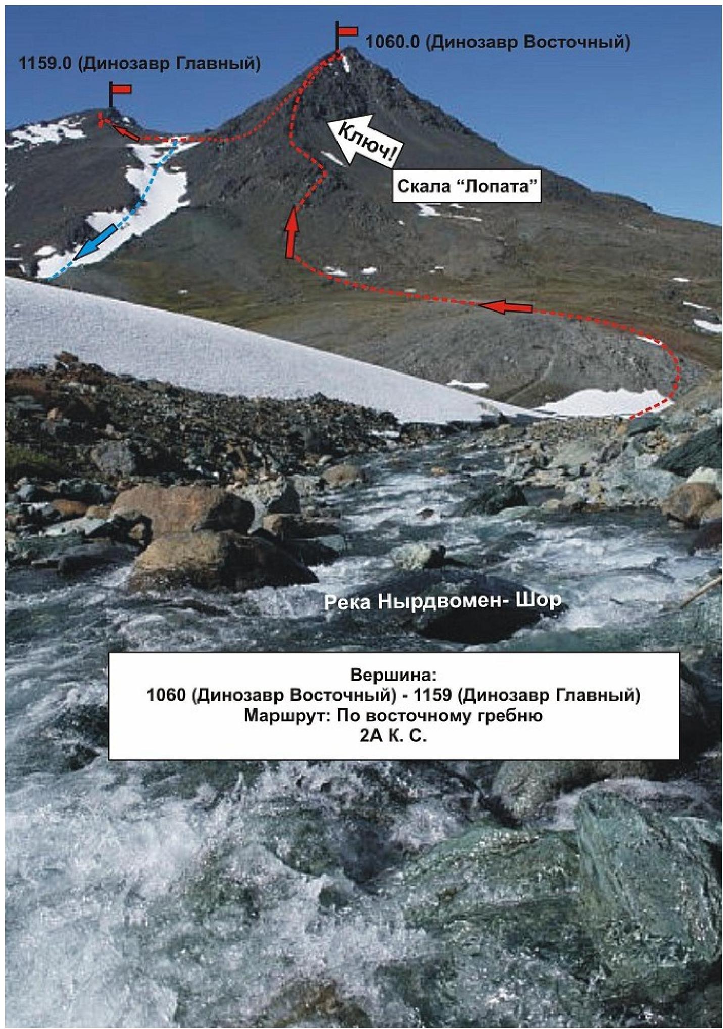
The peaks 1060 (Dinozavr Eastern) and 1159 (Dinozavr Main) are located in the Yamalo-Nenets Autonomous Okrug (YNAO) of the Tyumen Oblast, Ural Federal District of the Russian Federation, 30 km southeast of the 110 km halt (formerly the Polarny settlement), in the Nyrdvomen-Shor stream valley (a large right-bank tributary of the Sob river), on the eastern slopes of the Polar Urals. These peaks are the extreme northwestern peaks of the Raiiz mountain massif.
The peaks are well-defined and serve as objects for educational and sports ascents, as they have several pronounced rock ridges, corrie ridges, and walls located on:
- north,
- northwest,
- east,
- southeast.
The name of the mountain Dinozavr and the peaks — Dinozavr Eastern, Dinozavr Main — is unofficial, given by climbers for ease of orientation. The height of the mountain 1159.0 m is marked on official maps of the Russian Federation (scale: 1 cm — 1 km). A triangulation marker is installed on the summit.
Description of the route: "Via the southeast ridge" 2A (winter).
Route: "Via the southeast ridge (winter)" — a typical winter educational-training route of 2A cat. diff., having a minimal set of natural obstacles. Passing this route has not only aesthetic but also sports-practical significance, as it allows working out belaying and self-belaying techniques on snowy-icy and rocky terrain within the ascent. The route is logical in orientation, objectively safe, which allows conducting educational-sports and sports ascents in winter.
Equipment
For an ascent as part of an educational-sports group of 6 people (5 participants + instructor) on the route, the following special equipment is necessary:
Personal:
- Standard issue
- Crampons
- Ice axe — mandatory
Group:
- Main rope 10 mm — 3 pieces of 50 m
- Chock elements — 10 pieces
- Rock pitons — 4 pieces
- Ice screws — 3 pieces
- Quickdraws — 8 pieces
- Slings — 6 pieces
- Rock hammer — 1 piece
- Ice axe — 1 piece.
Approach
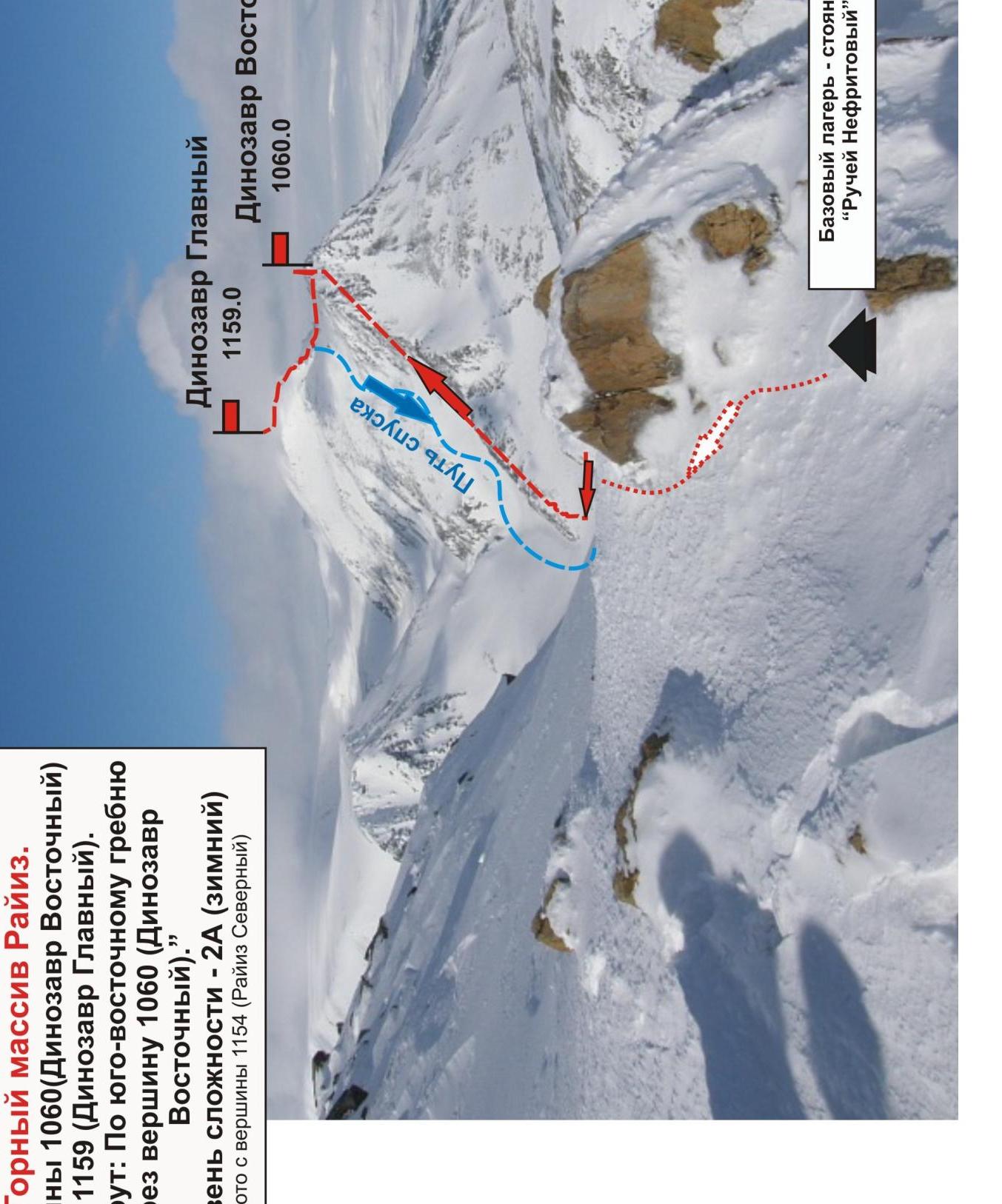
From the base camp — "Geologists' Balki, Nefritovy Stream" — cross the Nyrdvomen-Shor stream, then walk along the snowy slope to the beginning of the southeast ridge. At the base of the ridge — a convenient place for organizing rope teams.
Technical part
Ascent along the snowy slope to a pronounced inclined rock wall ("Lopata").
From the wall, exit onto the ridge. Further — movement along the ridge to the summit 1060 (Dinozavr Eastern), complicated by snow, ice, requiring participants to have mandatory skills in working with crampons on rocks.
The key to the route: the rock wall "Lopata".
For an educational group, it is recommended to work in interacting rope teams with the organization of running belays.
The cairn on the summit 1060 m may be snow-covered. After passing the key and exiting onto the summit 1060 m, move along the snowy-icy ridge to the summit 1159 m (Dinozavr Main). A cairn with a note under the metal pyramid of the triangulation marker.
Descent from the summit
Descent via the eastern couloir.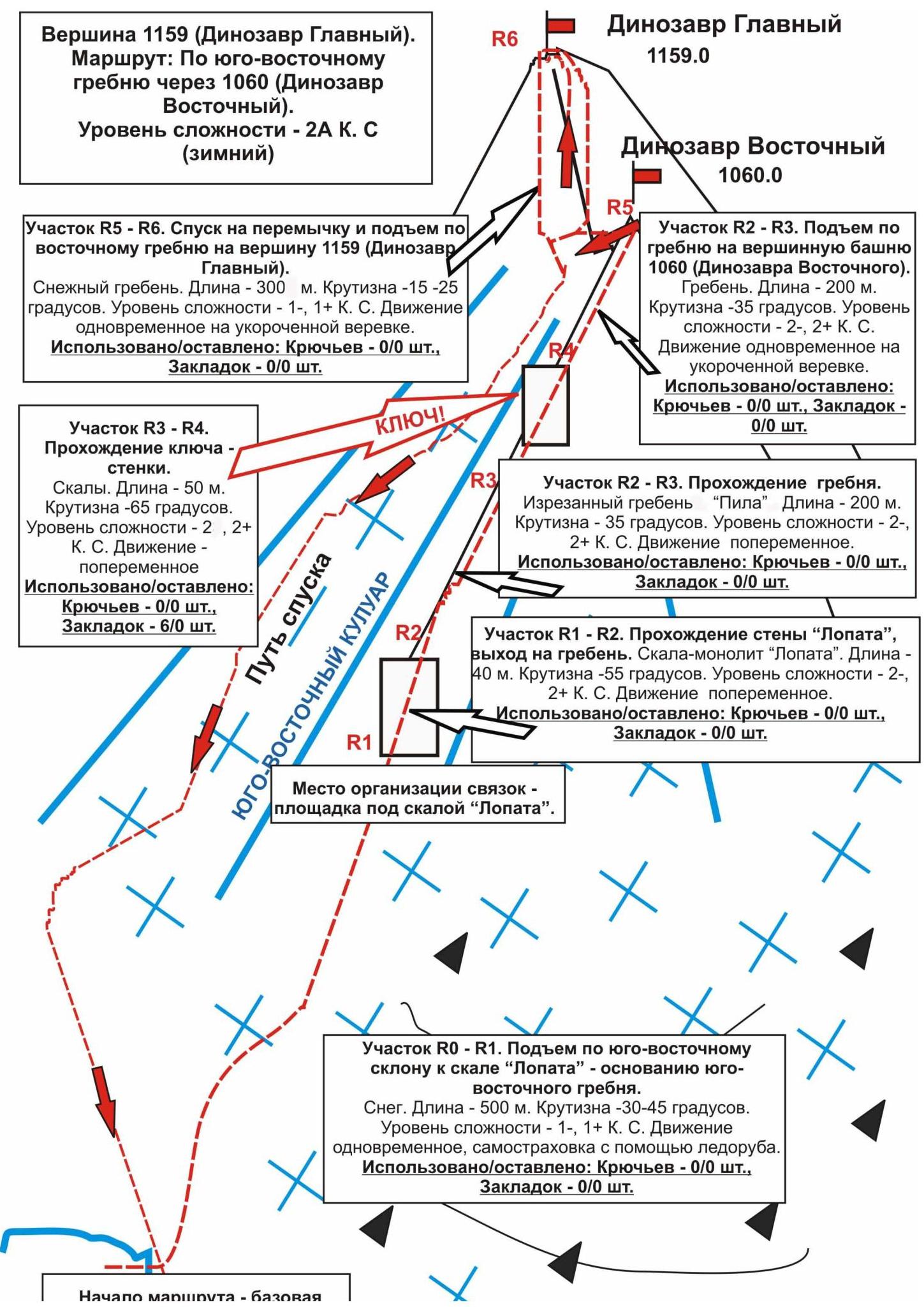
Start of the route —
base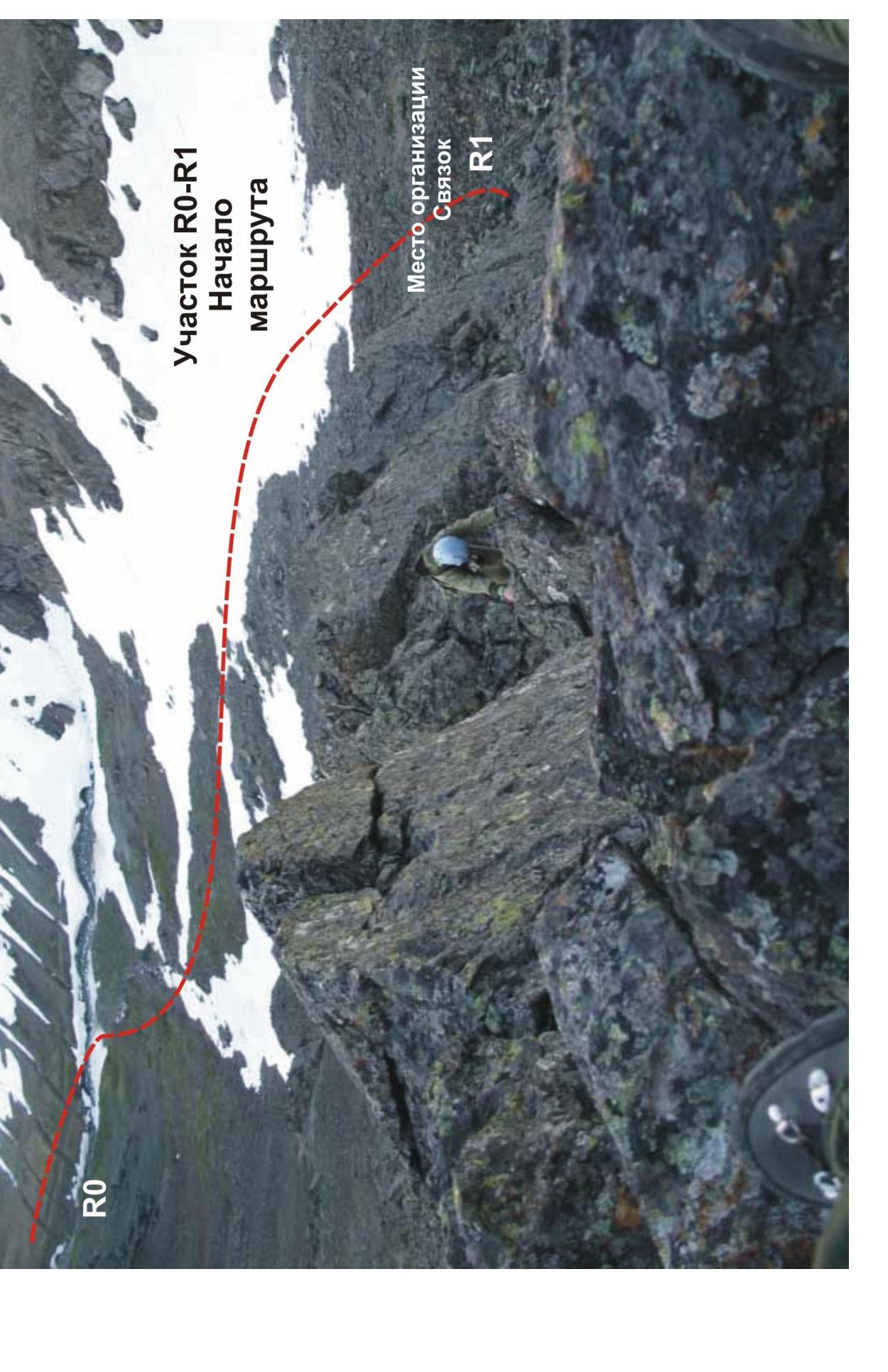

route 2A via the SE ridge
Polar Urals. Raiiz mountain massif.
peaks 1060 (Dinozavr Eastern) and 1159 (Dinozavr Main).
Route: Via the southeast ridge to the summit 1060 (Dinozavr Eastern).
cat. diff. — 2A (winter)
Photo from the summit 1154 (Raiiz Northern)
Summit: 1060 (Dinozavr Eastern) — 1159 (Dinozavr Main)
Route: Via the east ridge
cat. diff. — 2A
cat. diff.