Ascent Passport
Mountain region — Polar Urals Mountain range — Rai-Iz mountain massif Gorge — Nyrdvomen-Shor river valley. Section number according to KMGV-2001 — № 8. "Other mountain systems and massifs". Name of the peak — 1159 (Dinozavr Glavny). Elevation — 1159 m Route name — via the third buttress of the central rock massif of the northern wall of the western ridge Difficulty category — 4B cat. diff. Route character — rock Elevation gain — 950 m (according to the map of the General Staff of the Russian Federation: initial mark — 199 m, summit — 1159 m) Route length — 4–5 km Technically difficult sections — sections of 5 cat. diff. – 2, 6 cat. diff. – none Average steepness of the main (technical) part of the route — 70° Hooks on the route — left – 6. Used hooks – 8, placements – 24 pcs. Team's walking hours — 18 hours Group composition — team leader M. Kunevich (2nd sports category, Syktyvkar), V. Toropov (2nd sports category, Syktyvkar) Departure to the route — 6:00 July 1, 2007 Summit attainment — 16:00 July 1, 2007 Return to the base camp — 0:00 July 2, 2007 Organizations conducting the alpine event:
- "Alpinist Expedition of the Alpinism Federation of the Komi Republic"
- "Non-profit Partnership 'Club of Northern Travels 'Sauk-Pai' (Syktyvkar)"
- "Club of Tourists and Alpinists of Ukhta" Dates of the alpine event — from June 25 to July 10, 2007
Senior coach – releasing FARK (Federation of Alpinism of the Komi Republic) F.N. Fomenko (CMS, instructor-methodologist of the 1st category, cert. № 07, Ukhta)
Senior coach – releasing alpine event S.V. Zhuravlev (CMS, instructor-methodologist of the 2nd category, cert. № 1124, Syktyvkar)
Federation of Alpinism of the Komi Republic, Syktyvkar, 2007
Peak Description
Peak 1159 (Dinozavr Glavny) is located in the Rai-Iz mountain massif of the Polar Urals, within the Yamalo-Nenets Autonomous Okrug of the Russian Federation beyond the Arctic Circle.
A characteristic feature of the routes to this peak via the northern wall of the western ridge are complex rock buttresses with an abundance of various rock relief, from small inclined walls and slabs to prolonged internal corners, often ending in cornices at the beginning, and prolonged movement along a heavily destroyed, rocky- talus ridge when ascending to the summit. A feature of the peaks of the Polar Urals is that there is a sequential increase in complexity from the start of the route to the summit tower.
The elevation gain from the start of the route (mark of the water's edge at the base camp in the Nyrdvomen-Shor river valley above sea level — 199 m, summit — 1159 m) is more than 800 m.
Peak 1159 (Dinozavr Glavny) is included in the list of classified peaks. The first routes to this peak were laid by Ukhta alpinists in the winter seasons of 1995–1999. They also gave the peak its alpinist name, as this peak does not have an independent name.
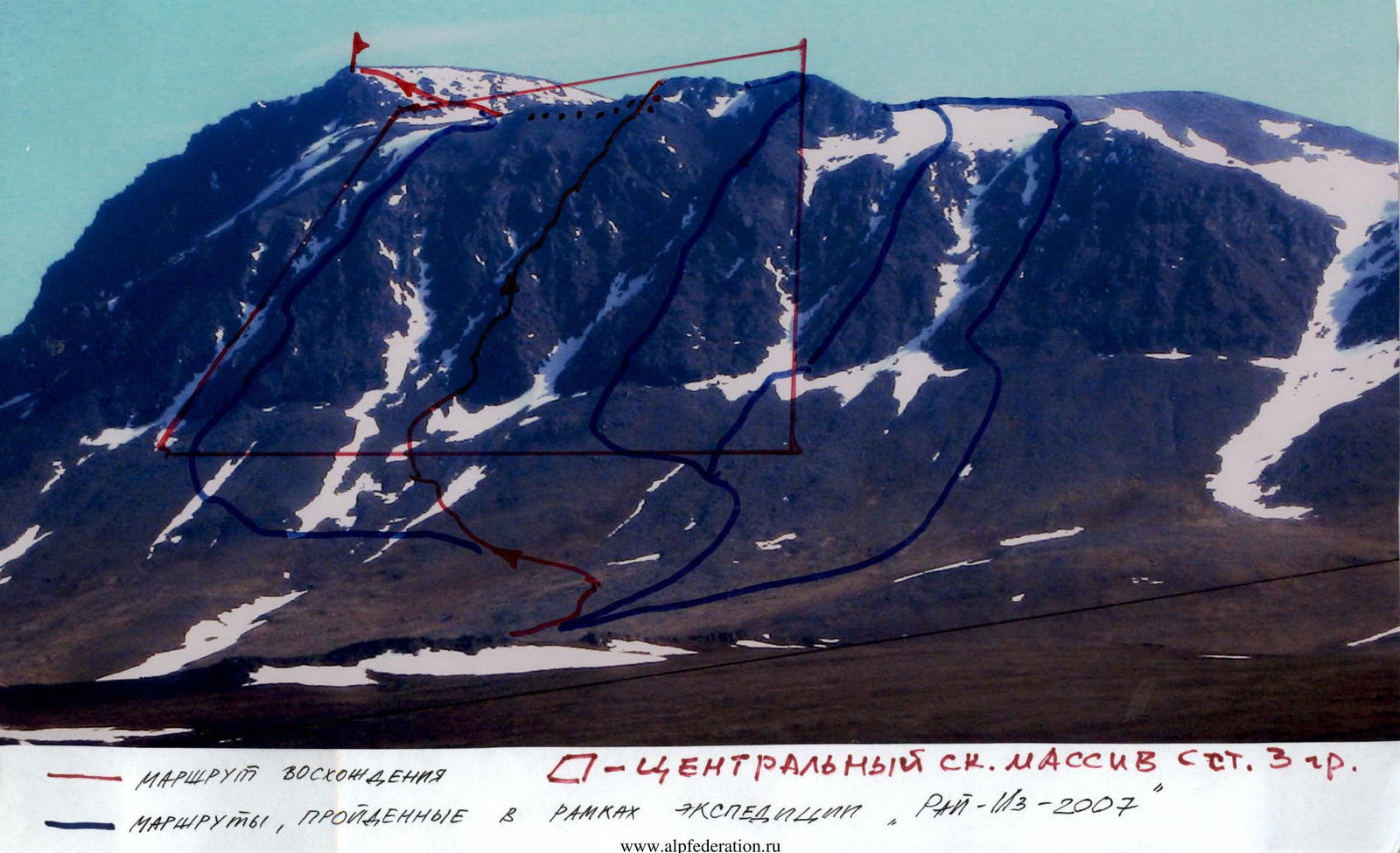
From the valley of the Nyrdvomen-Shor stream, the most convenient location for a base camp — a large larch-alder oasis in the tundra — the peak is easily recognizable by its pronounced rock walls and buttresses of the northern and northern walls of the western ridge.
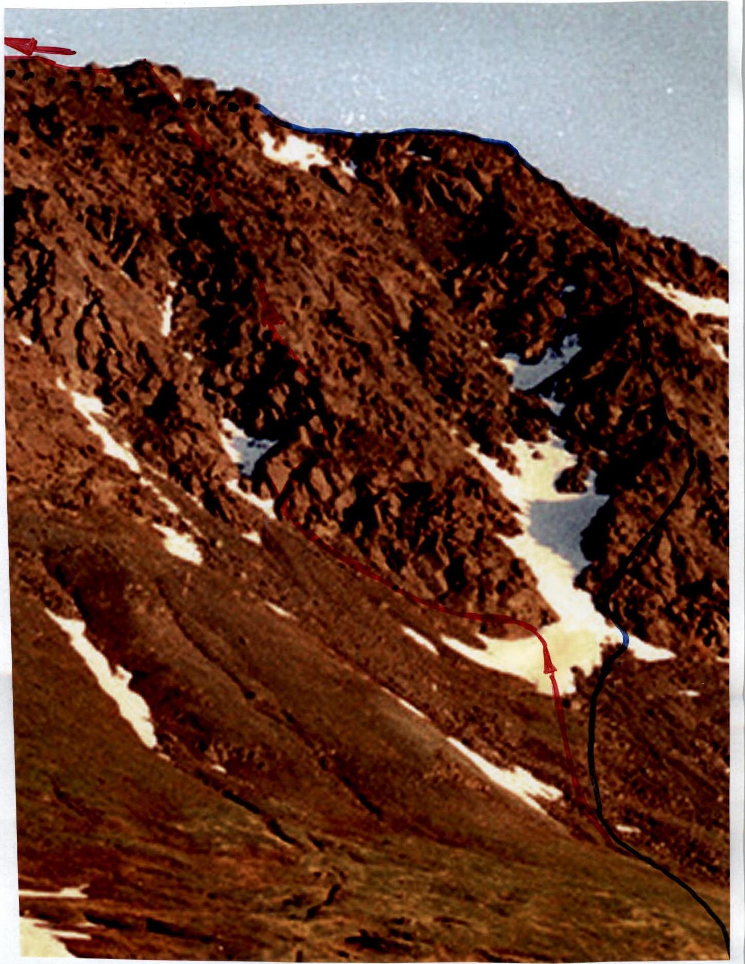
TECHNICAL PHOTO OF ROUTE 13 from the Nardvomen-Shor river valley
Route Description
Route: The third buttress of the central rock massif of the northern wall of the western ridge of peak 1159 (Dinozavr Glavny) is pronounced. It is clearly visible from the base camp in the Nyrdvonon-Shor river valley. The not too impressive average steepness of the buttress, visible from the base camp, is deceptive, as it is masked by the pyramidal structure of the rock ridge of the buttress, where technically complex monolithic rock 20–30-meter walls alternate with ridge sections of small steepness. The apparent simplicity of the route should not mislead ascent participants and provoke them into being unprepared for the rock passage.
Approach: Moving from the bivouac in the Nyrdvomen-Shor river valley (see attached map-scheme), cross the Nyrdvomen-Shor river by wading, go around the green golets to the right (in the direction of travel), and ascend to a large rock remnant. From it, to the right in the direction of travel, traverse along talus slopes, crossing a snowfield, and approach the rock "paw" of the third (from left to right from the summit) buttress of the western ridge. Then, along the heavily destroyed rock ridge, exit under the rock base of the buttress. At the base of the buttress, rope up.
A characteristic landmark for the start of the route is the rock "Triangular Mirror" on the right side of the "paw" — the rock base of the buttress.
Technical part of the route: To the left of the rock "Triangular Mirror" is an inclined rock wall. It is more convenient to start the ascent by passing it, as both the rock "Triangular Mirror" and the rock massif to the left are technically more complex. The wall leads under the base of an inclined internal corner. After passing the internal corner, a station is necessary. There are enough large, convenient ledges, but there is no convenient shelf, as movement is carried out along inclined rock slabs. The station is in a semi-hang.
Further on is a prolonged section of climbing, consisting of five inclined walls, of which the third is the most complex to pass, as it is climbed on minimal holds using friction. The base station is also inconvenient, not allowing more than two people to gather, and is organized on a small inclined shelf. Insurance is carried out in a semi-hang on self-insurance. The next section consists of three rock walls of varying steepness, leading to the "Roof" terrace. This is the first rock shoulder of this buttress, where the entire group can gather, and it is the only place on the route where there is water.
Further along a technically simple oblique shelf and ridge, we approach the base of an internal corner on the right side of the buttress. The corner, initially leading to the right, changes direction after 10 m and turns left, leading to the rock ridge. A base station for insurance is on a convenient platform. Further on is another inclined internal corner to the right of the rock ridge, after which there are two 15-meter walls of complicated climbing along monolithic slab-like rocks with an exit to an inclined shelf- slab. The base station is inconvenient — in a semi-hang on self-insurance. A short, moderately complex internal corner leads to the second shoulder of the rock ridge of the buttress. The ridge is heavily destroyed, rocky-talus, and approaches an inclined, heavily destroyed internal corner (Subjective rockfall danger!). There is a place for a base station on the right side at the exit from the internal corner. Further on is a series of rock shelves of varying steepness, and несложное lazing along the shelves leads to the "Beak" jendarme. The jendarme is well expressed on the ridge and is a landmark for the start of the key section of the route.
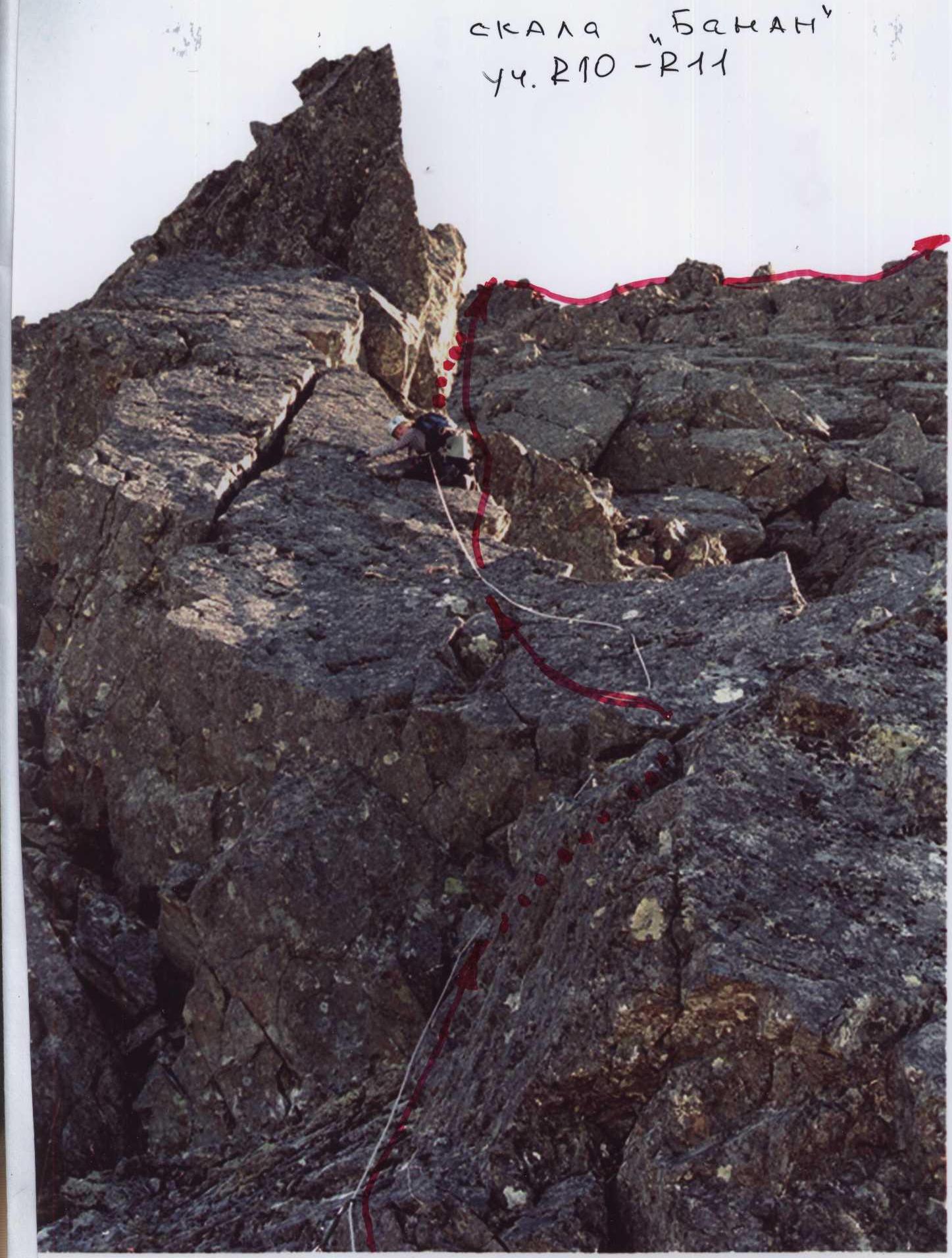
The key to the route — the rock "Banana" (resembling a banana in shape), is complex not only technically but also psychologically, as the complex smoothed rocks of the curved semi-ridge, semi-wall end in a rock overhang. The key is passed on the right.
First along the smoothed ridge, then traverse along an inclined shelf under the overhang. Complex climbing diagonally on minimal holds using friction and anti-push with minimal cracks for organizing intermediate insurance points. Further on are five meters of the curved ridge of the rock "Banana". Again, movement is on friction and anti-push with minimal cracks for intermediate insurance points. Further on is a bypass of the overhang along a steep five-meter rock wall, exit under a steep short internal corner, and passage of a one-and-a-half-meter cornice. The cornice is psychologically complex but is passed by climbing Through the cornice is done by climbing, without using artificial support points. After the cornice, a small wall and oblique shelf lead to the second rock shoulder of the buttress. The upper base station is convenient, with an abundance of large rock blocks, on which insurance and self-insurance can be organized, as well as the entire group can gather. Further passage of the route does not present difficulties for разрядников. The ridge of the buttress expands and becomes more gentle. A series of inclined walls, alternating with oblique shelves, leads to a talus ridge, then to an osypnoy dome of the summit. From the osypnoy dome, descent to the pre-summit plateau, approach under the rock tower of the summit along taluses, then ascent along несложным rocks, and passage along the ridge to the summit Dinozavr Glavny.
The summit is well expressed. On the summit is a triangulation mark.
Equipment: for a sports group of people:
- Main rope — 2 pcs. × 10 mm × 50 m
- Rock hooks — 10 pcs.:
- Petals — 5
- Titanium wedges — 5
- Boxes — 5
- Horizontal and vertical — 5
- Placement elements — 26 pcs.:
- Small stoppers — 16
- "Sails" stoppers — 6
- Hexes — 4
- Station loops — 6 pcs.
- Quickdraws — 10 pcs.
- Tent — 1 pc.
- Primus (gas burner) — 1 pc.
- Pot — 1 pc.
- Personal gear for each participant.
Note to the Instructor:
- The route requires participants to have high-quality rock preparation, mastery of not only modern rock climbing techniques when passing smoothed sections and cornices, but also skills in organizing intermediate insurance points using placement elements on micro-relief.
- In case of bad weather, the group needs to have a set of "gift" hooks and loops, as the key to the route is in the upper part, so in case of withdrawal, participants will have to descend down via dully-ferry over ten ropes, and organizing an overnight stay on the rocks of the buttress is quite difficult.
- In the summer, there is a significant resource — the Polar day allows for significantly increasing the time of movement along the route.
- For a comfortable bivouac on the route, there is one place on the buttress — the "Roof" terrace; further on, a tent can be installed only after exiting to the pre-summit.
- The rocks are dense, monolithic. Rockfall danger is subjective, depending on the participants themselves. The buttress is limited by rockfall-dangerous in summer and avalanche-dangerous in winter couloirs.
Peak: 1159 (Dinozavr Glavny)
Route: "Via the third buttress of the central rock massif of the northern wall of the western ridge"
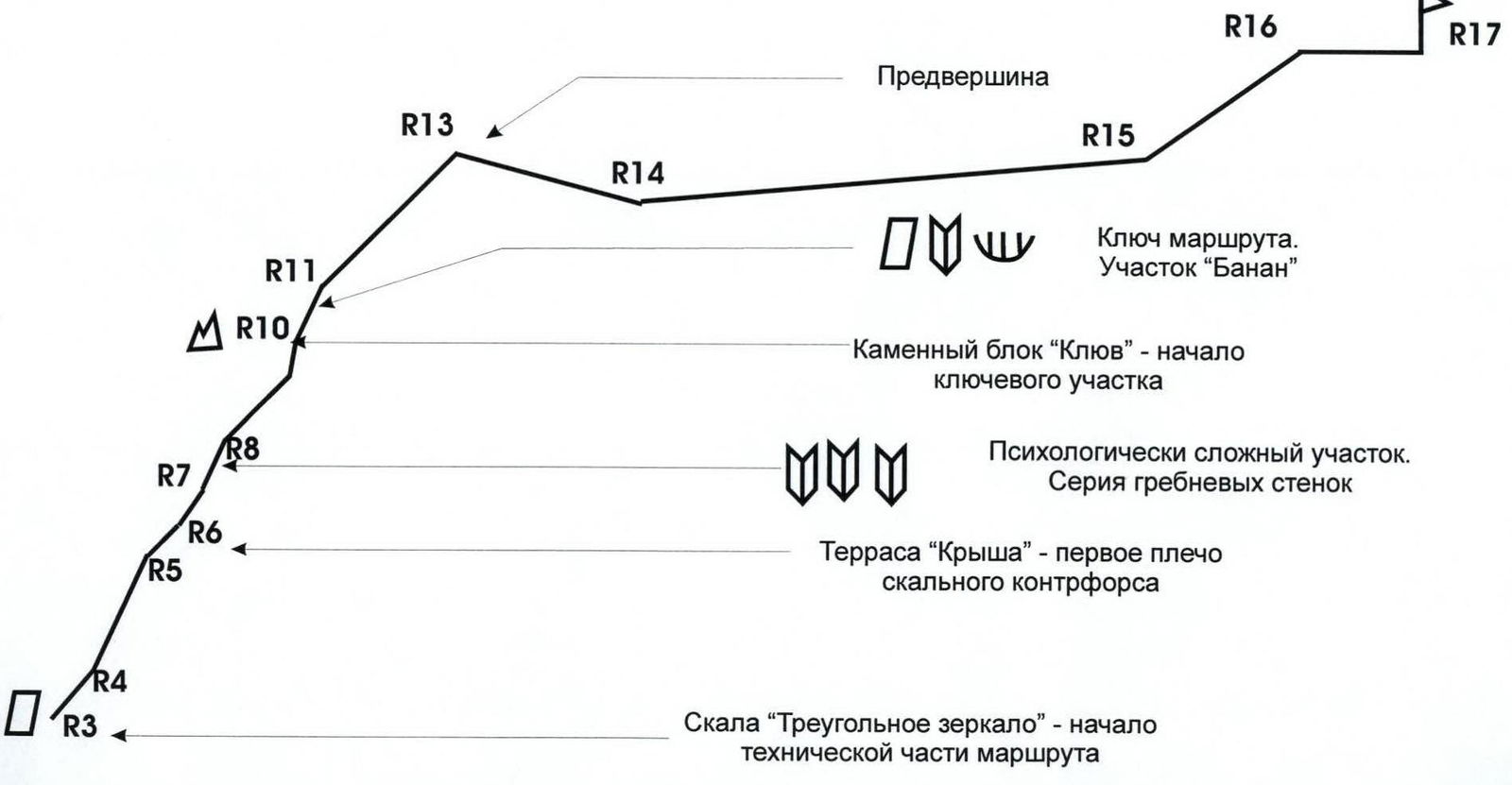
Graphical Profile of the Technical Part of the Route with Indication of the Most Complex Sections
Scale: 1 cm – 50 m
 Profile of SECTION R5–R11 PHOTO from the second buttress of the S wall of the 3rd ridge
Technical Description to the Route Scheme in UIAA Signs
R0 — base camp in the larch oasis of the Nyrdvomen-Shor river.
R0–R1 — Base camp – crossing the Nyrdvomen-Shor river.
Crossing the Nyrdvomen-Shor river by wading (depth 40–60 cm; during periods of abundant snowmelt, organization of rope insurance is required). Section length — 500 m, steepness — 0–5°. Complexity level — non-categorical.
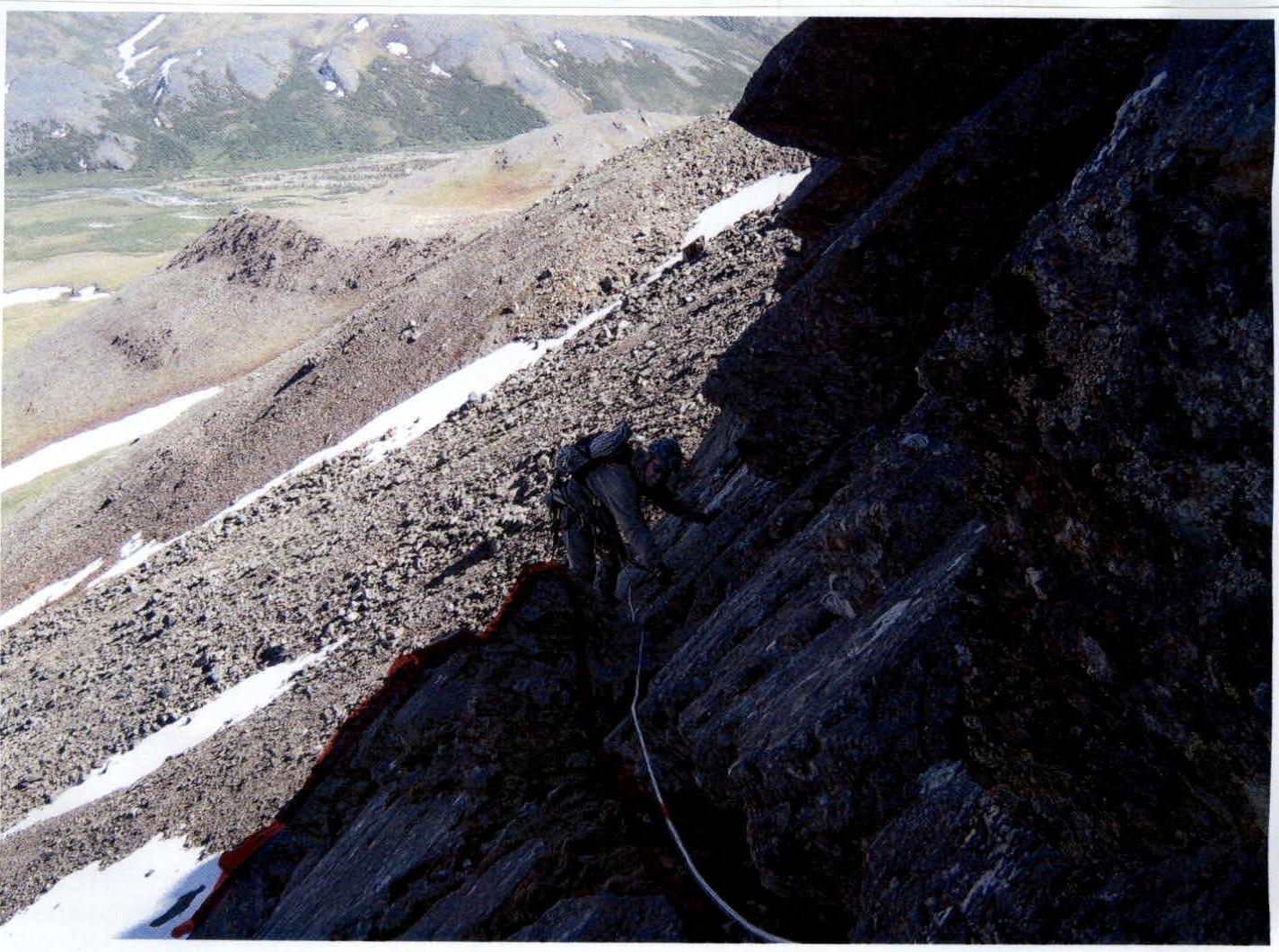
R1–R2 — bypassing the Green Golets and approaching the rock remnant on the green talus. Mountain tundra, kurumniks. Section length — 2500 m. Section steepness: initially 30–45°, in the upper part 45–50°. Complexity level — non-categorical.
R2–R3 — Traversing talus and snow slopes, ascending along destroyed rocks to the "Triangular Mirror" rock to organize rope teams. Large-block talus, snow. Section length — 100 m. Section steepness — 45–50°. Complexity level — 1B cat. diff. Insurance during movement along large rock blocks is gymnastic. Control point for the start of the route is at the "Triangular Mirror" rock.
R3–R4 — Passage of an oblique wall and inclined internal corner. Rocks. Convenient holds and supports, abundant cracks and fractures for organizing insurance points. Section length — 50 m, of which 5 m along the inclined internal corner. Steepness — 50°. Complexity level — 3B cat. diff. Insurance is alternating.
R4–R5 — Exit to the ridge of the buttress and passage of five consecutive equivalent inclined rock walls to an oblique shelf. Monolithic smoothed rocks. The first wall — 25 m, the second — 25 m, the third, fourth, and fifth — 15 m each. After the second wall, a weakly expressed shelf with an inconvenient but only place for a base station. Section length — 95 m. Section steepness — 60°. Complexity level — 3B cat. diff. Station is semi-hanging. Movement of participants is alternating.
R5–R6 — Passage of an oblique wall. Exit to the "Roof" terrace. Oblique wall. Rocks with an abundance of holds and cracks for organizing insurance. Section length — 100 m. Section steepness — 60–70°. Complexity level — 3B, 4B cat. diff. Insurance is hook-based, using placement elements. Quickdraws are mandatory to reduce friction. Movement of participants is alternating. Exit to the "Roof" terrace — the first rock shoulder of the buttress.
R6–R7 — Passage of the rock ridge and oblique wall. Monolithic rocks. Section length — 35 m. Section steepness — 45°. Complexity level — 2B cat. diff. Group movement with alternating insurance. Exit to a convenient rock shelf on the right side of the ridge.
R7–R8 — Passage of three internal corners. Monolithic rocks. The first internal corner is on the right in the direction of travel, the second turns left and leads to the ridge, the third is along the ridge. The most complex for passage is the third internal corner, as it is necessary to pass an overhang of half a meter in the center of the corner. Section length — 30 m. Section steepness — 50–60°. Complexity level — 3B cat. diff. When passing the overhang in the internal corner — 4B cat. diff. Movement is alternating. Insurance is hook-based. Using placement elements, loops thrown over ledges. Base insurance station is on a shelf after passing two internal corners. Internal corners lead under walls on the ridge.
R8–R9 — Passage of a series of ridge walls. Monolithic rocks. Minimum holds, minimum cracks for organizing intermediate insurance points. Small holds are smoothed, so it is necessary to use friction, anti-push, and balance. Psychologically complex section. Section length — 45 m. Section steepness:
- In the lower part — 60°
- In the upper part — 70° Complexity level — 4B cat. diff. Movement is alternating. Insurance is hook-based, using placement elements. Exit to a rock shelf under an internal corner. The shelf is inconvenient, the station is semi-hanging.
Scheme in UIAA signs

| Length | Steepness | Complexity | Hooks | Placements | Photo № | |
|---|---|---|---|---|---|---|
| R11 | 50 m | 65° | 3B cat. diff. | 0 | 12 | № |
| R10 | 30 m | 80° | 5B cat. diff. | 8 / 2 | 12 | |
| R9 | 50 m | 45° | 2B cat. diff. | 0 | 0 | |
| 30 m | 30° | 1B, 2A cat. diff. | 0 | 0 | №4 | |
| R8 | 45 m | 60° | 4B cat. diff. | 3 | 8 | № |
| R7 | 30 m | 60° | 3B, 4B cat. diff. | 8 | 6 | № |
| R6 | 35 m | 45° | 2B cat. diff. | 0 | 3 | № |
| R5 | 100 m | 70° | 3B, 4B cat. diff. | 8 | 18 | № |
| R4 | 95 m | 65° | 3A, 3B cat. diff. | 6 / 2 | 18 | № |
| R3 | 50 m | 50° | 3B cat. diff. | 0 | 12 | № |
R9–R10 — Passage of the talus ridge and heavily destroyed internal corner. Approach along a series of oblique shelves to the "Beak" stone block. Large-block talus. Internal corner with a heavily destroyed left side (in the direction of travel) (Rockfall danger!). Section length — 30 m. Steepness — 45–50°. Complexity level — 1B, 2A cat. diff. Movement is simultaneous. Series of oblique rock shelves. Rocks. Climbing of medium complexity. Section length — 50 m, steepness — 45°. Complexity level — 2B cat. diff. Exit to the "Beak" stone block — the main landmark for the start of the key section of the route.
R10–R11 — Passage of the rock ridge "Banana" — the key section of the route. Monolithic rocks. Complex orientation for passage on the right side (detailed passage is described in the appendix to the scheme in UIAA signs). In the upper part of the key is the passage of a cornice. Section length — 30 m. Steepness up to the cornice — 80°. Cornice — 1.5 m with a negative angle. Complexity level — 5B cat. diff. Movement is alternating. Organization of insurance using hooks and placement elements; when passing the cornice, ITO and ladders were used. Above the cornice is a semi-hanging, very inconvenient station. Mandatory use of quickdraws to straighten the rope and eliminate excess friction.
R11–R12 — Passage of a series of ridge rock walls. Rocks. Section length — 50 m. Steepness — 65°. Complexity level — 3B cat. diff. Movement is simultaneous.
R12–R13 — Exit to the talus ridge and pre-summit. Rocks, large-block talus turning into medium-block talus. Section length — 150 m. Section steepness: in the lower part — 45°, in the upper part — 30°. Complexity level: in the lower part — 2B, in the upper part — 2A cat. diff. Movement is simultaneous. Organization of insurance through ledges, loops on ledges, and large rock blocks.
R13–R14 — Descent to the pre-summit plateau. Talus, destroyed rock ridge. Section length — 150 m. Section steepness — 15°. Complexity level — non-categorical. Movement is simultaneous. Insurance is gymnastic.
R14–R15 — Approach along the plateau under the summit rock dome. Talus. Section length — 400 m. Section steepness — 5°. Complexity level — non-categorical. Movement is simultaneous. Insurance is gymnastic.
R16–R17 — Passage of the rock massif of the summit dome and exit along the ridge to the summit. Rocks. Section length — 250 m. Section steepness — 35°. Complexity level — 2A, 2B cat. diff. Movement is simultaneous, on a shortened rope. Organization of insurance through ledges.
R17 — summit 1159 (Dinozavr Glavny). R17–R0 — Descent via route 1B (z) through the center of the eastern slope. Talus, snow. Crossing the Nyrdvomen-Shor river by snow bridges. (Snow bridges are subjectively dangerous in summer!). All-terrain vehicle road through mountain tundra. Section length — 4–5 km. Complexity level: in the upper part — 1A, 1B cat. diff., in the lower part — non-categorical.
 N2 section R5–R6
 N3 Section R8–R9 Exit to the 2nd rock shoulder.
 N4 R9–R10 "approach to the rock block and Beak"