Ascent Passport
Mountain region — Polar Urals
Mountain range — Rai-Iz mountain massif
Gorge — Nyrdvomen-Shor river valley.
Section number according to KMGV-2001 — № 8. "Other mountain systems and massifs".
Name of the peak — 1159 (Dinozavr Glavny).
Height — 1159 m
Route name — via the western snow-ice couloir of the northern wall
Complexity category — 2A (approx.).
Route character — combined
Height difference — 950 m (according to the General Staff of the Russian Federation map: initial mark above sea level — water edge of Nyrdvomen-Shor river at the base camp — 199 m, peak above sea level — 1159 m).
Route length — 4–5 km
Technically difficult sections:
- sections of 5th cat. diff. — none
- 6th cat. diff. — none
Average steepness of the main (technical) part of the route — 55°.
Average steepness of the entire route — 45°.
Pitons on the route — none left. Used pitons — none.
Team's walking hours — 10 hours
Group composition:
- leader P. A. Bondaruk (2nd sports category, Syktyvkar)
- Yu. V. Valuzhis (2nd sports category, Syktyvkar)
- I. A. Boyko (2nd sports category, Syktyvkar)
- S. V. Zhuravlev (Candidate for Master of Sports, Syktyvkar)
Departure to the route — 6:00, June 26, 2007 Ascent to the summit — 14:00, June 26, 2007 Return to base camp — 16:00, June 26, 2007
Organization conducting the alpine event:
- Alpine expedition of the Alpinism Federation of the Komi Republic
- NP "Sauk-Pai North Travel Club" (Syktyvkar)
- Club of tourists and alpinists of Ukhta
Dates of the alpine event — from June 25 to July 10, 2007
Senior coach — releaser FARK (Alpinism Federation of the Komi Republic)
- F. N. Fomenko (Candidate for Master of Sports, instructor-methodologist 1st category, ud. № 07, Ukhta)
Senior coach — releaser of the alpine event
- S. V. Zhuravlev (Candidate for Master of Sports, instructor-methodologist 2nd category, ud. № 1124, Syktyvkar)
Alpinism Federation of the Komi Republic Syktyvkar, 2007

8.1159 (Dinozavr Glavny) — Route via s-l couloir, 1B cat. diff.
Description of the peak
Peak 1159 (Dinozavr Glavny) is located in the Rai-Iz mountain massif of the Polar Urals, within the territory of the Yamalo-Nenets Autonomous Okrug, Russia, beyond the Arctic Circle.
A characteristic feature of the routes to this peak is the height difference from the start of the route (mark above sea level 199 m) to the summit (1159 m), i.e., a difference of over 800 m.
Peak 1159 (Dinozavr Glavny) is included in the list of classified peaks. The first routes to this peak were laid by Ukhta alpinists in the winter seasons of 1995-1999. They also gave the peak its alpinist name, as it did not have a local name.
From the valley of the Nyrdvomen-Shor stream, the most convenient location for a base camp — a large larch-alder oasis in the tundra — the peak is easily recognizable by its pronounced rock walls and buttresses of the northern and northwestern walls of the Western ridge.
Description of the route
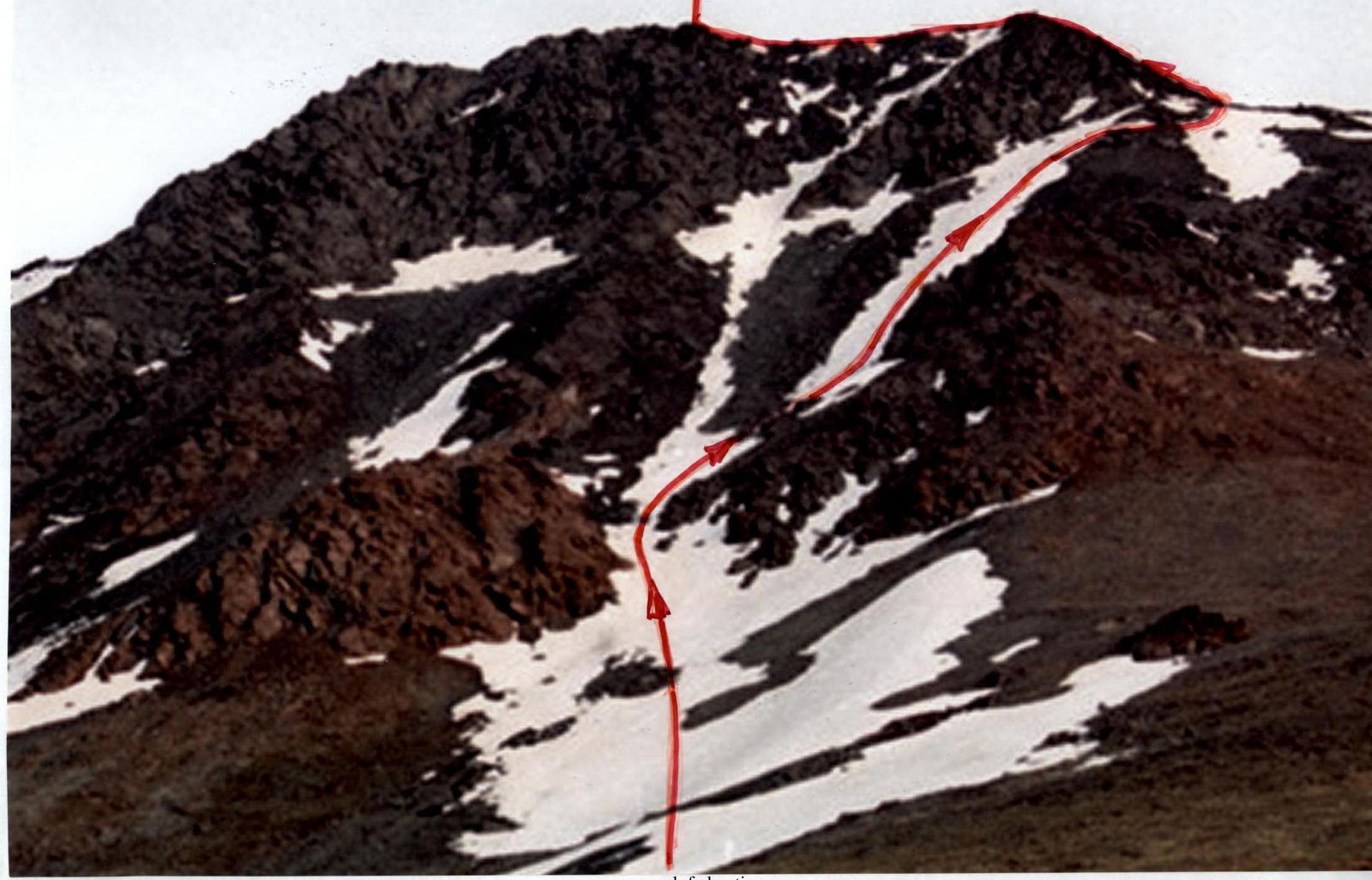
Route: The western snow-ice couloir of the northern wall separates the northern wall from the northern wall of the Western ridge. It is easily recognizable from the Nyrdvomen-Shor river valley, as it separates the rock masses of the northern wall and the northern wall of the Western ridge and leads to the summit dome.
Approach: Moving from the bivouac in the Nyrdvomen-Shor river valley (see the attached map-scheme), go around the green bald mountain to the right (in the direction of movement) and ascend to the beginning of the snow couloir.
Technical part of the route:
- Go around large rock outcrops to the left (in the direction of movement), ascending along the snow tongue with a steepness of 45°.
- For novice groups, it is convenient to tie in on a safe platform between large rock blocks under the rocks, as further on the snow, in a wide but constantly increasing steepness couloir, organizing rope teams is quite difficult.
- Under a layer of snow in the summer — ice, it is recommended to use crampons for movement.
- Further, having ascended the couloir for 150–200 m, go traverse to the right onto large-block scree.
- Climbing on large blocks is not difficult, with gymnastic belay.
- Further along the scree, ascend to the right snowpatch and along the snow, exit onto the Western ridge of peak 1159 (Dinozavr Glavny).
- Then along the Western ridge (to the left in the direction of movement) approach the rock dome of the summit.
- Along simple rocks, ascend to the ridge, then along the ridge exit to the summit.
The summit is well-defined, composed of large blocks. Climbing is not difficult. On the summit — a triangulation sign.
Descent from the summit — via the ascent route. There is also a safer but longer descent route: "Via the center of the eastern slope and the eastern ridge" (1B).
In the summer period this is:
- safe,
- not steep,
- a long snow couloir, allowing the group to descend with minimal time loss to the geological all-terrain road.
The most difficult section when descending and returning to the base camp — crossing the upper reaches of Nyrdvomen-Shor along snow bridges, the passage of which in the summer requires organization of belay.
Equipment: for a sports group of four people:
- main rope 2 pcs. × 10 mm × 50 m
- crampons — 4 pairs
- ice axes — 4 pcs.
- ice screws — 2 pcs.
- rock pitons — 4 pcs.
- anchor loops — 4 pcs.
- quickdraws — 6 pcs.
- stove (gas burner) — 1 pc.
- pot — 1 pc.
- personal equipment — for each participant.
Recommendations for the instructor: This route is the closest to the standard training and sports alpinist routes of 1B cat. diff. of the Rai-Iz mountain massif, Peak 1159 (Dinozavr Glavny). Route: Via the western snow-ice couloir of the northern wall 1B cat. diff. (Combined).
Technical description of the route to the UIAA sign scheme
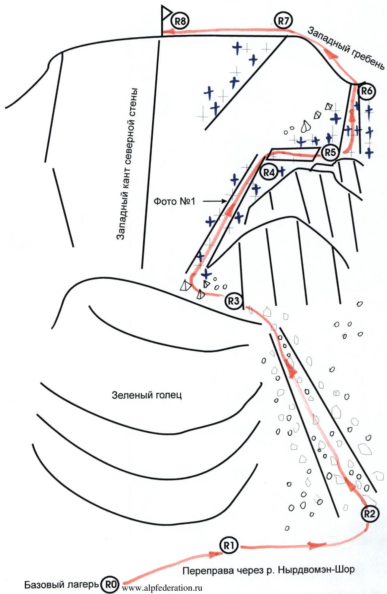
R0 — base camp in the larch oasis of Nyrdvomen-Shor river.
R0–R1 — base camp — crossing the Nyrdvomen-Shor river.
Crossing the Nyrdvomen-Shor river ford (depth 40–60 cm, during the period of abundant snowmelt, organization of rope belay is required). Section length — 500 m, steepness — 0°. Difficulty level — non-categorized.
R1–R2 — going around the green bald mountain and approaching the start of the route. Mountain tundra, scree. Section length — 2500 m. Section steepness: initially — 30–45°, in the upper part — 45–50°. Difficulty level — non-categorized. Belay on individual sections — gymnastic.
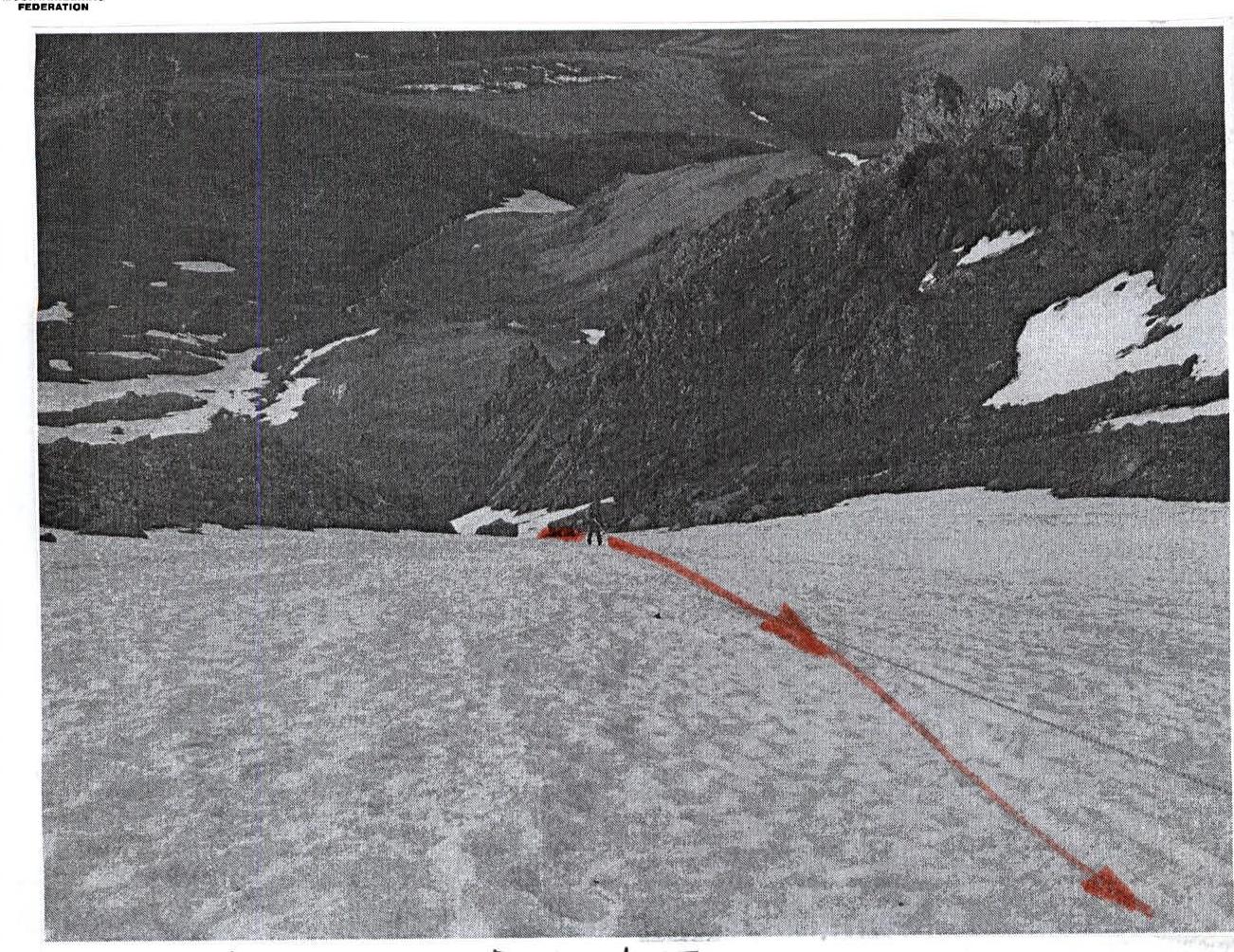
R2–R3 — approaching the rock massif for organizing rope teams. Large-block scree, snow. Section length — 100 m. Section steepness — 45–50°. Difficulty level — 1. Belay when moving along large rock blocks — gymnastic.
R3–R4 — going around rock massifs along the snow-ice couloir. Snow, ice. Rock islands. Section length — 200 m. Steepness — 55–60°. Difficulty level — 1, 2. Variable belay. Organization of belay stations — on ice axes.
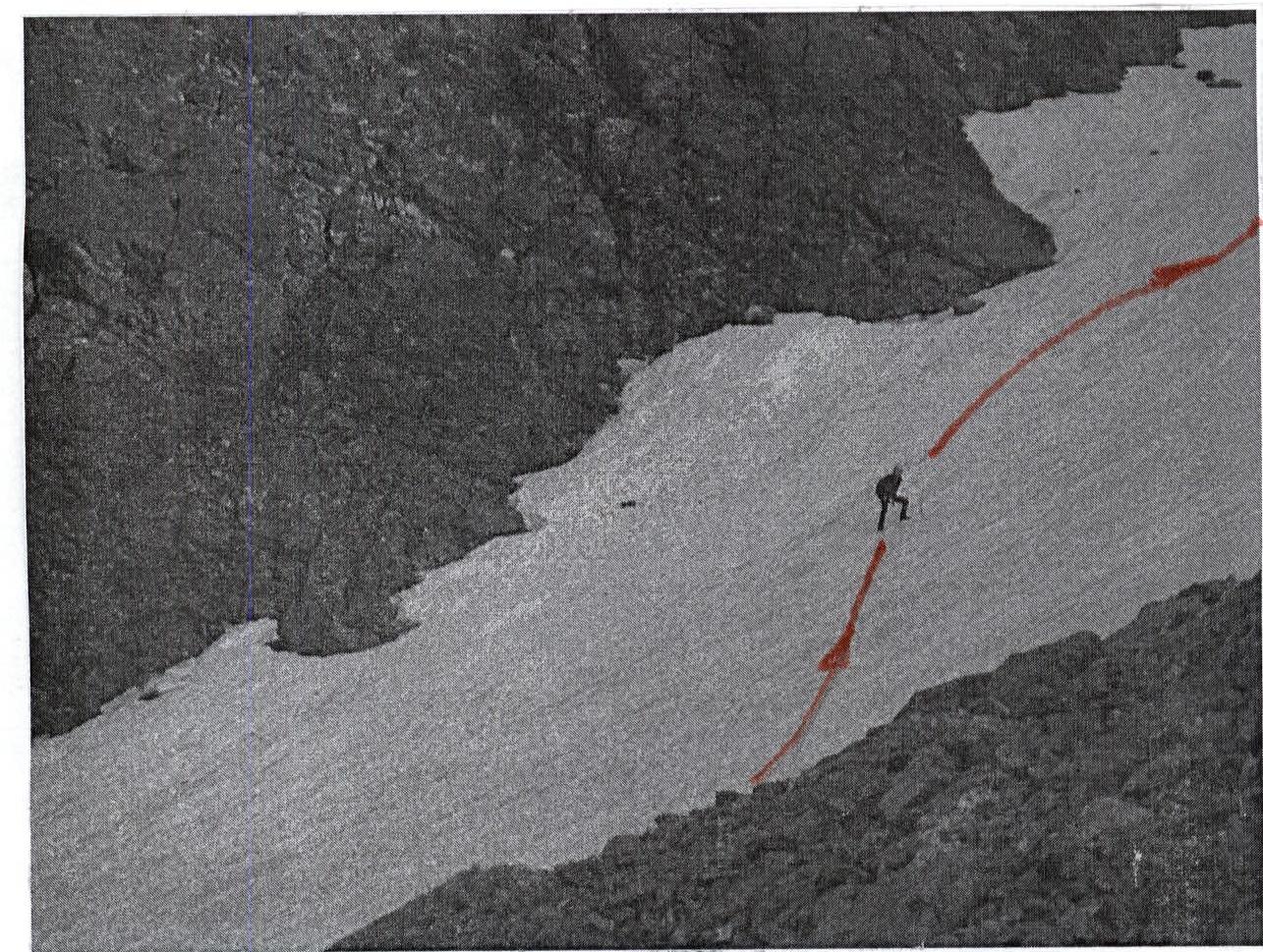
R4–R5 — diagonal traverse of the rock slope to the base of the right snow-ice couloir of the western slope. Severely destroyed rocks, scree. (Subjective rockfall danger!). Section length — 180–200 m. Section steepness — 45°.
- Slab-like rock outcrops, overgrown with moss, covered with fine scree
- Difficulty level: 1, 1
- Participants' movement is simultaneous, on a shortened rope
- In some cases — with rope placement behind outcrops
R5–R6 — exit to the Western ridge. Snow, ice. Section length — 500 m. Section steepness: initially 30–45°, in the upper part — 55–60°. Difficulty level — 2, 2. Movement — with alternate belay, with organization of stations on ice axes.
R6–R7 — approach along the Western ridge to the summit dome. Snow, medium-block scree. Section length — 200–250 m. Section steepness — 10–15°. Difficulty level — non-categorized. Simultaneous movement, rope in coils.
R7–R8 — exit to the summit. Severely destroyed rocks, large-block scree. Section length — 150 m. Section steepness — 60°. Difficulty level — 1, 2.
R8 — summit 1159 (Dinozavr Glavny).
R8–R0 — descent along the center of the eastern slope. Scree, snow. Crossing the Nyrdvomen-Shor river along snow bridges. (Snow bridges in the summer are subjectively dangerous!). All-terrain road through the mountain tundra. Section length — 4–5 km. Difficulty level: in the upper part — 1, 1, in the lower part — non-categorized.
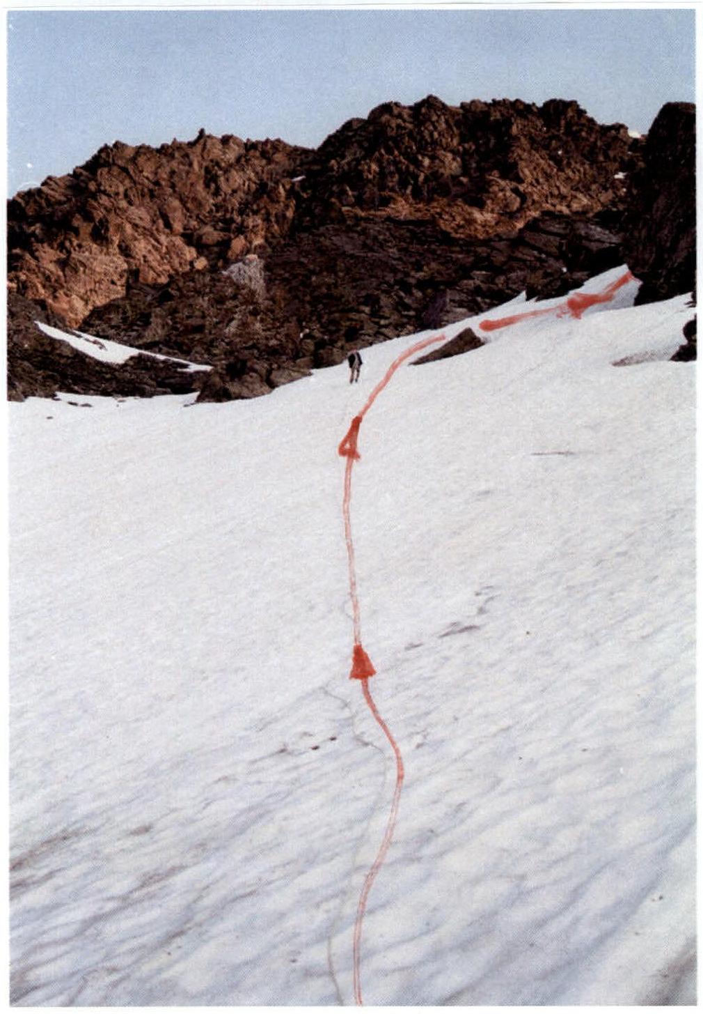
Photo № 1. Section R3–R4.
Section R4–R5
Section R4–R5 (traverse)
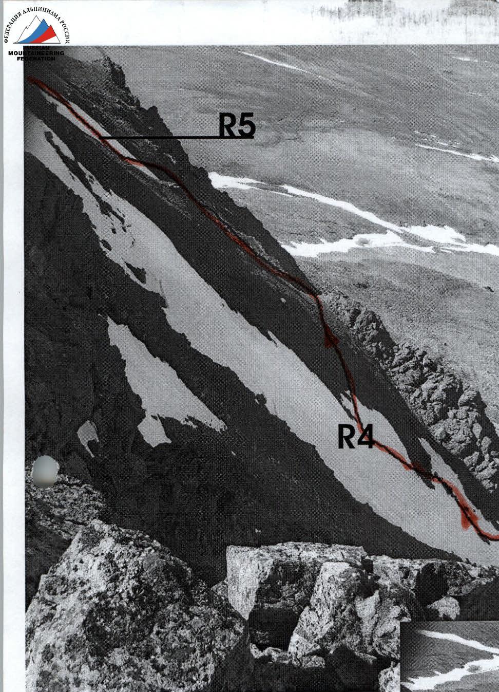
Photo 2, 2A. Sections of the western couloir route.