Ascent Record
Mountain region — Polar Urals Mountain range — Rai-Iz massif Gorge — Nyrdvomen-Shor river valley Section number according to KMGV-2001 – № 8. "Other mountain systems and massifs" Peak name — 1060 (Dinozavr Eastern) Height — 1060 m Route name — via the bastion of the northern edge of the eastern ridge Difficulty category — 4B cat. dif. Route type — rock Height difference — 950 m (according to the map of the General Staff of the Russian Federation: elevation mark of the water's edge at the base camp in the Nyrdvomen-Shor river valley – 199 m, elevation mark of the peak — 1060 m above sea level) Route length — 2000 m, technical part — 450 m Technically difficult sections:
- sections of 5 cat. dif. – 3
- 6 cat. dif. – 1 Average steepness of the main (technical) part of the route — 85° Pitons on the route:
- left — 3
- used — 6 Placement elements used — 24 Team's working hours — 12 Group composition:
- leader E. V. Donyushko (2nd sports category, Ukhta)
- Yu. V. Valuzhis (2nd sports category, Syktyvkar)
- I. A. Boyko (2nd sports category, Syktyvkar)
- P. A. Bondaruk (2nd sports category, Syktyvkar) Approach to the route — 6:00, June 29, 2007 Reached the summit — 14:00, June 29, 2007 Return to base camp — 18:00, July 29, 2007 Organization conducting the alpine event — "Alpinist Expedition of the Alpinism Federation of the Komi Republic 'Rai-Iz – 2007'", NP "Club of Northern Travels 'Sauk-Pai'" (Syktyvkar) and Club of Tourists and Alpinists of Ukhta Dates of the alpine event — from June 25 to July 10, 2007
Senior coach — releasing FARK (Federation of Alpinism of the Komi Republic) F. N. Fomenko (CMS, instructor-methodologist 1st category, ud. № 07, Ukhta)
Senior coach — releasing alpine event S. V. Zhuravlev (CMS, instructor-methodologist 2nd category, ud. № 1124, Syktyvkar)
Federation of Alpinism of the Komi Republic, Syktyvkar, 2007
Route Illustrations
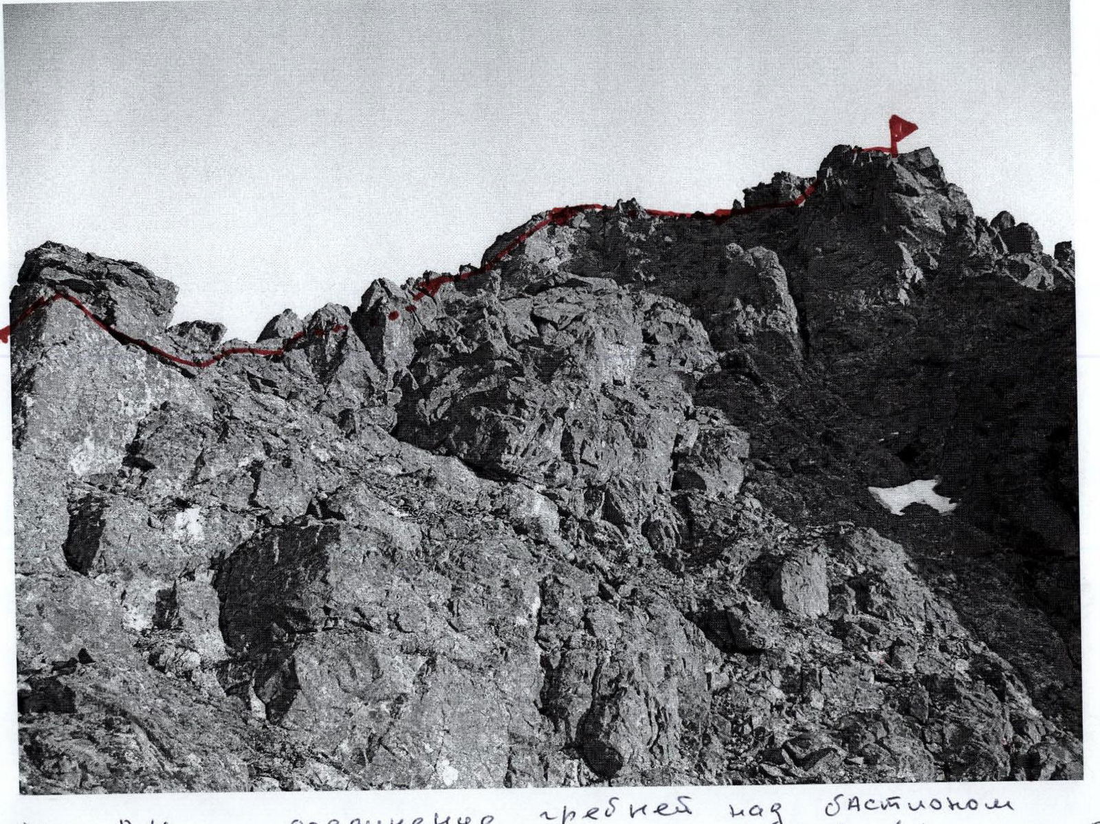
ROUTE "VIA THE BASTION OF THE NORTHERN EDGE OF THE EASTERN RIDGE"
Peak 1060 (Dinozavr East)
Route "via the bastion of the northern edge of the ridge" (profile)
Route "via the Eastern Ridge" (passed during the Rai-Iz-2007 expedition)
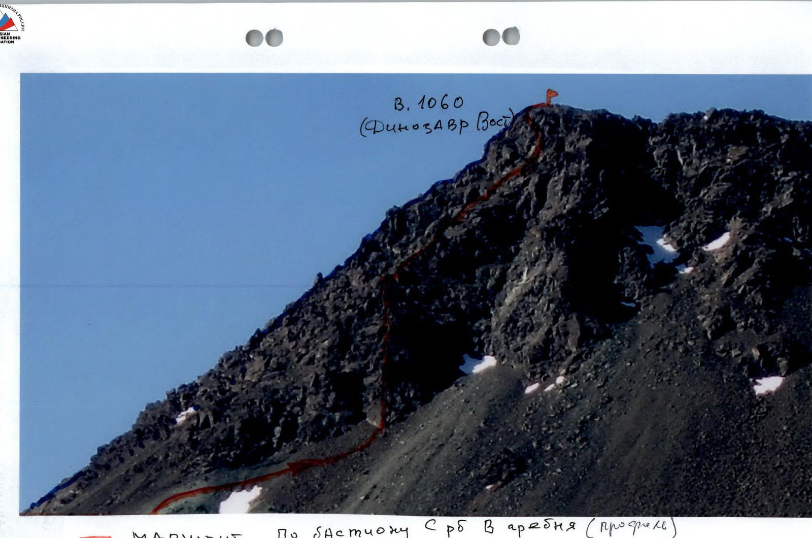
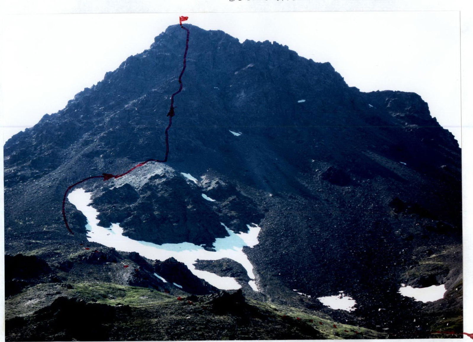
Peak 1060 (Dinozavr Eastern). Photo from the east.
Ascent route.
Peak Description
Peak 1060 (Dinozavr Eastern) is located in the Rai-Iz massif of the Polar Urals, within the Yamalo-Nenets Autonomous Okrug of the Russian Federation, beyond the Arctic Circle. It is the eastern peak of the mountain with a geodetic mark of 1129 (Dinozavr). The elevation mark of Dinozavr Eastern is 1060 m above sea level.
Peak 1060 (Dinozavr Eastern) is included in the list of classified peaks. The first routes to this peak were laid by Ukhta alpinists in the winter seasons of 95-99. They also gave the peak its alpinist name, as it did not have an independent name.
From the valley of the Nyrdvomen-Shor stream, the most convenient location for a base camp — a large larch-alder oasis in the tundra — the peak is easily recognizable as the left peak of the dominant mountain massif in this valley.
Route Description
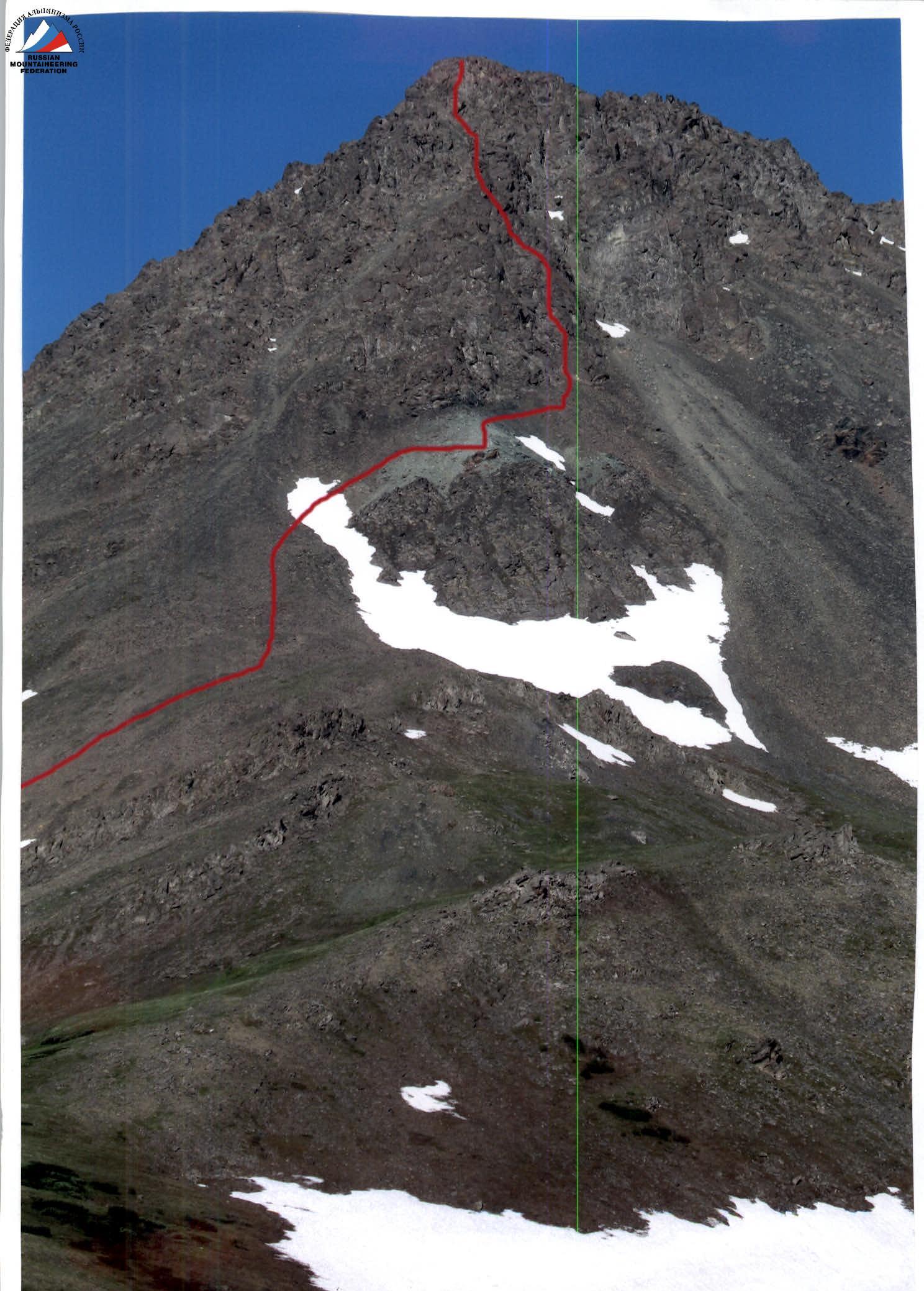
Route: "Via the bastion of the northern edge of the eastern ridge". From the Nyrdvomen-Shor river valley, the route is clearly visible and recognizable by the large rock island under the bastion, bounded above by a scree ridge of green-colored rocks.
Approach: Moving from the camp in the Nyrdvomen-Shor river valley (see the attached map-scheme), go around to the left (in the direction of travel) the green bald mountain, then the snowfield framing the rock island from below, and, having ascended under the rock masses of the summit tower, traverse the slope along medium-block scree, ascend to the green scree above the rock island. Then approach the start of the route.
Under the bastion, a control cairn marks the beginning of the route.
Technical part of the route:
- Difficult rocks begin immediately from the green scree.
- The route is clearly visible — "head-on", as both to the right and left there are drop-offs — "mirrors" with overhangs.
- Initially, a ten-meter wall with a cleft allows one to reach a weakly expressed ridge.
- The ridge is not long, about 30 m, and abuts a series of cornice-like features, between which, on the left part, is a technically difficult wall.
- The section is complex both technically and psychologically, as one of the rock cornices hangs over it.
- The cornice is overcome by climbing.
- Further — an exit to a ledge, on which there is a convenient place for organizing a base station.
- Then a weakly expressed ridge leads to an internal angle with a cleft.
- In the upper part of the internal angle — a cornice.
- The cornice is overcome using IT.
- Ladders are suspended on pitons and placement elements.
- This section is the minor key of the route (a point of return in case of bad weather or insufficient technical preparedness of the group).
- Further — a ridge section composed of large rock blocks.
- The ridge abuts a wall with a diagonal crack.
- The right side is more convenient for ascent, as it has more cracks and fractures, allowing for reliable intermediate belay points.
- The wall leads to a strongly jagged rock ridge with an abundance of "gendarmerie".
- This ridge is traversed along large rock blocks to the right.
- After bypassing the "gendarmerie" of the ridge, the ascent continues along rock ledges and small walls.
- Easy climbing (subjective rockfall danger, as there are stones on the ledges between the walls).
- A series of small walls leads to a weakly expressed ridge, leading to the base of an internal angle with a cleft and a cornice in the upper part.
- To the left and right of the internal angle are rock drop-offs with overhangs, so the path through the internal angle is clearly visible.
Key to the route: The internal angle is steep and technically complex, with a 1.5 m cornice at the top. IT was used during the passage. Ladders were suspended on pitons and placement elements. The length of the key section using IT is 15 m.
After passing the cornice:
- Exit to the junction of three ridges — eastern, north-eastern, and western.
- Easy ridge climbing.
- The ridge leads to a scree, composed of large-block debris material, forming the summit dome.
The summit is well-defined. At the summit, there is a triangulation marker. A cairn is located at the base of the triangulation marker.
Descent: The recommended descent is along the center of the eastern slope via route 1B, as the safest.
Equipment for a sports group of four:
- Main rope — 3 pcs. × 10 mm × 50 m
- Rock pitons — 16 pcs.
- Placement elements — 34 pcs.
- Station loops — 6 pcs.
- Quickdraws — 12 pcs.
- Primus (gas burner) — 1 pc.
- Pot — 1 pc.
- Personal equipment — for each participant.
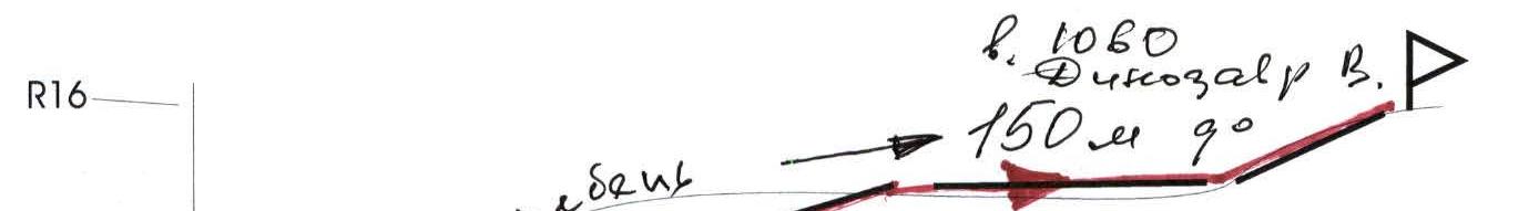
Peak: 1060 (Dinozavr Eastern), route: via the bastion of the northern edge of the eastern ridge
Graphical profile of the technical part of the route indicating the most difficult sections. Scale: 1 cm – 50 m
Internal angle with cornice — "Main Angle"
- Key to the route. Cornice 2 m.
Rock wall with diagonal cracks.
Internal angle with cornice at the exit. Cornice 1.5 m.
Wall between cornices. Difficult orientation.
Wall with cleft. Difficult climbing.
Route sketch: "Via the bastion of the northern edge of the eastern ridge" 4B cat. dif. indicating the most difficult sections.
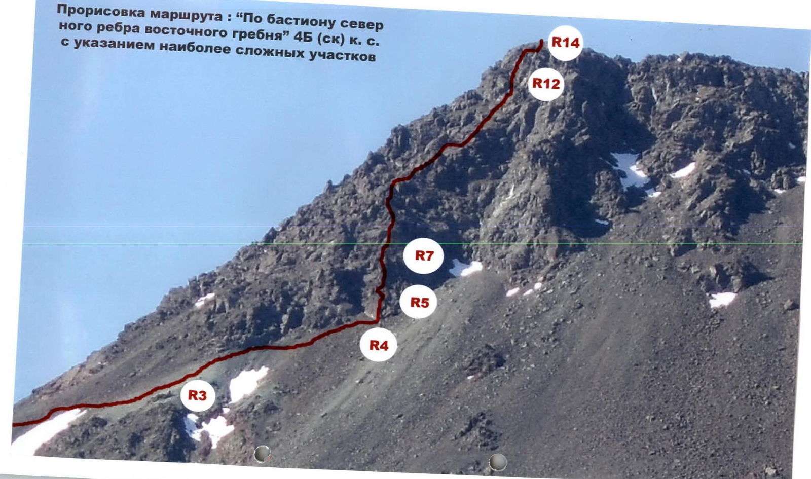
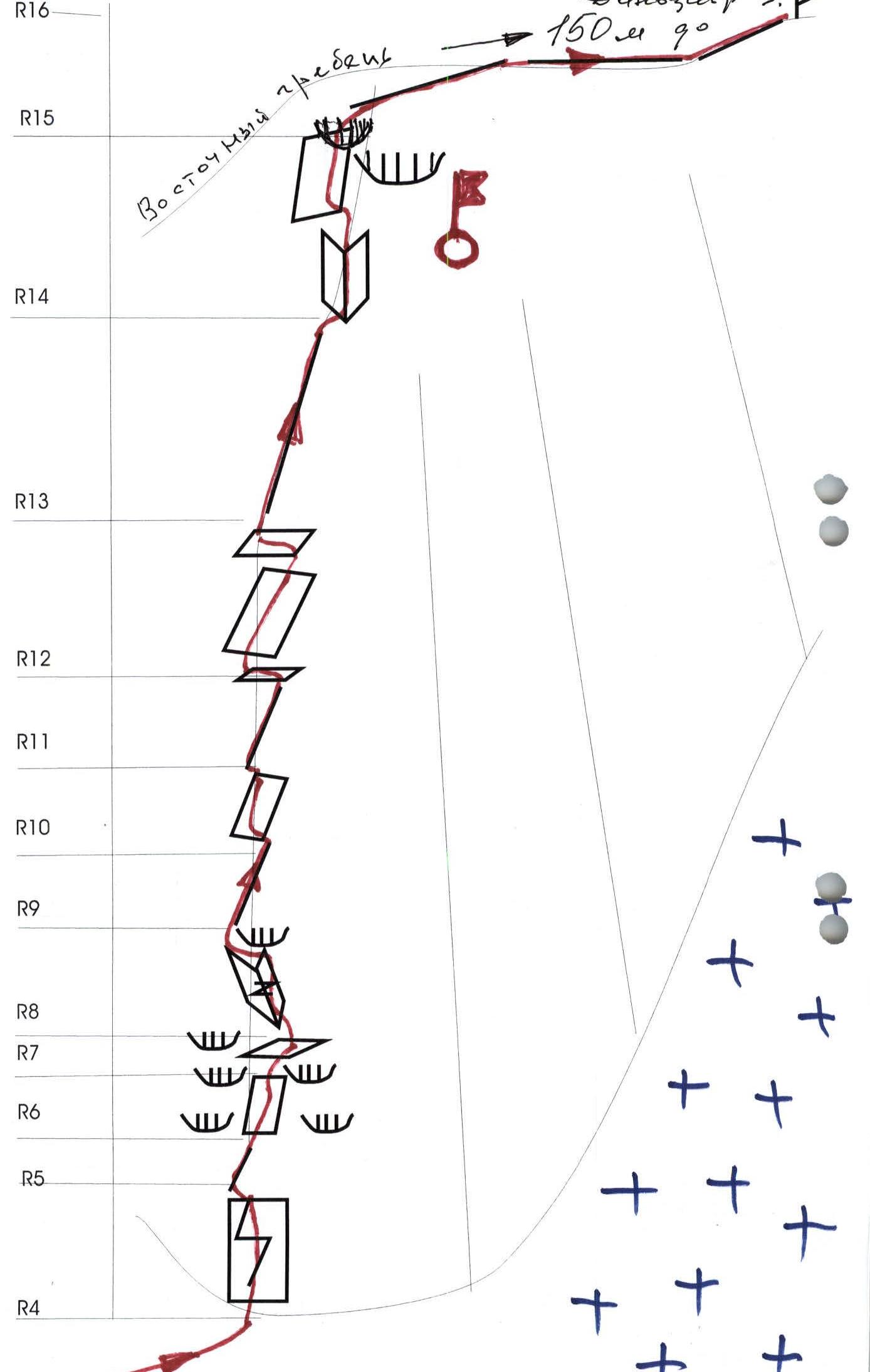
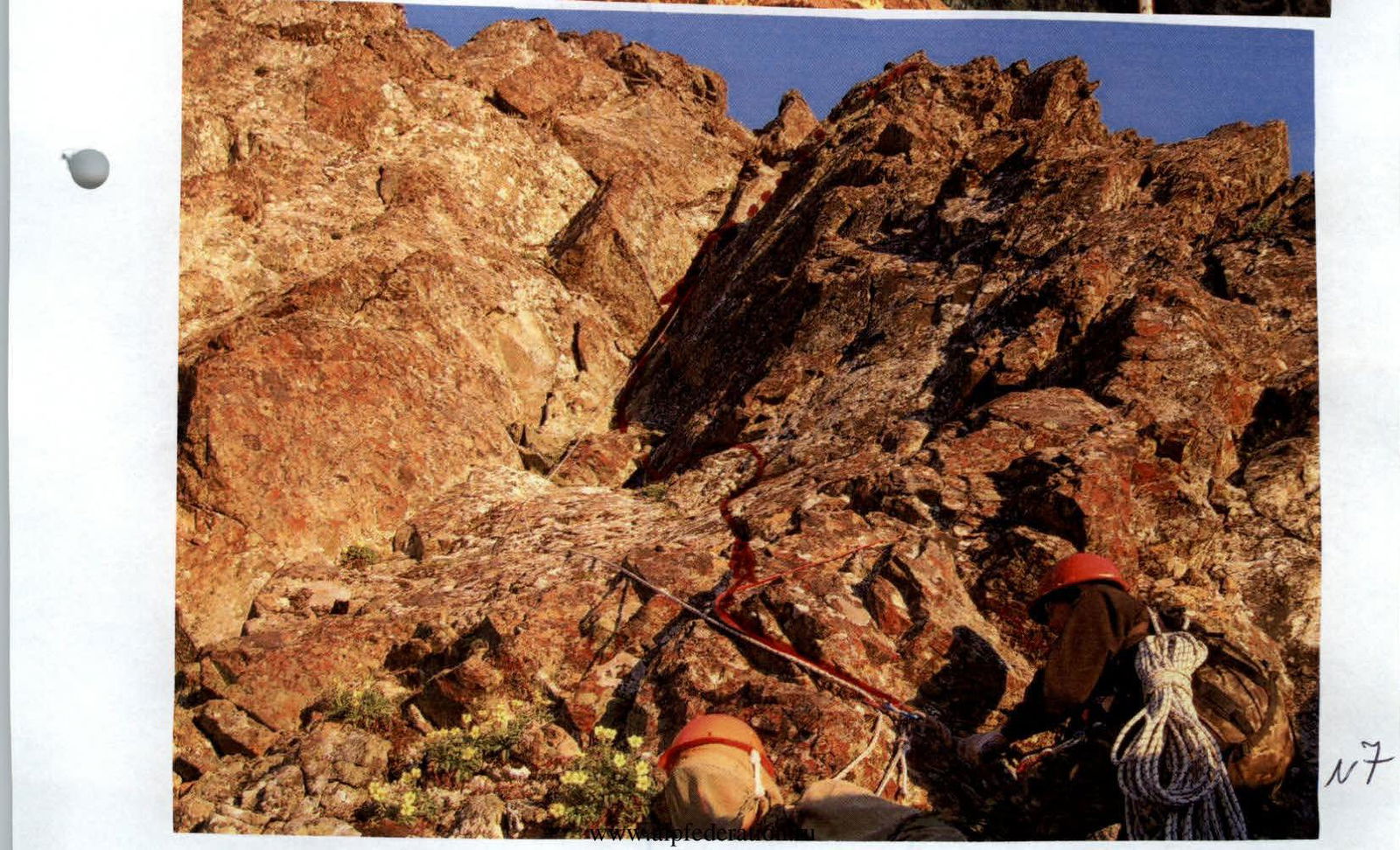
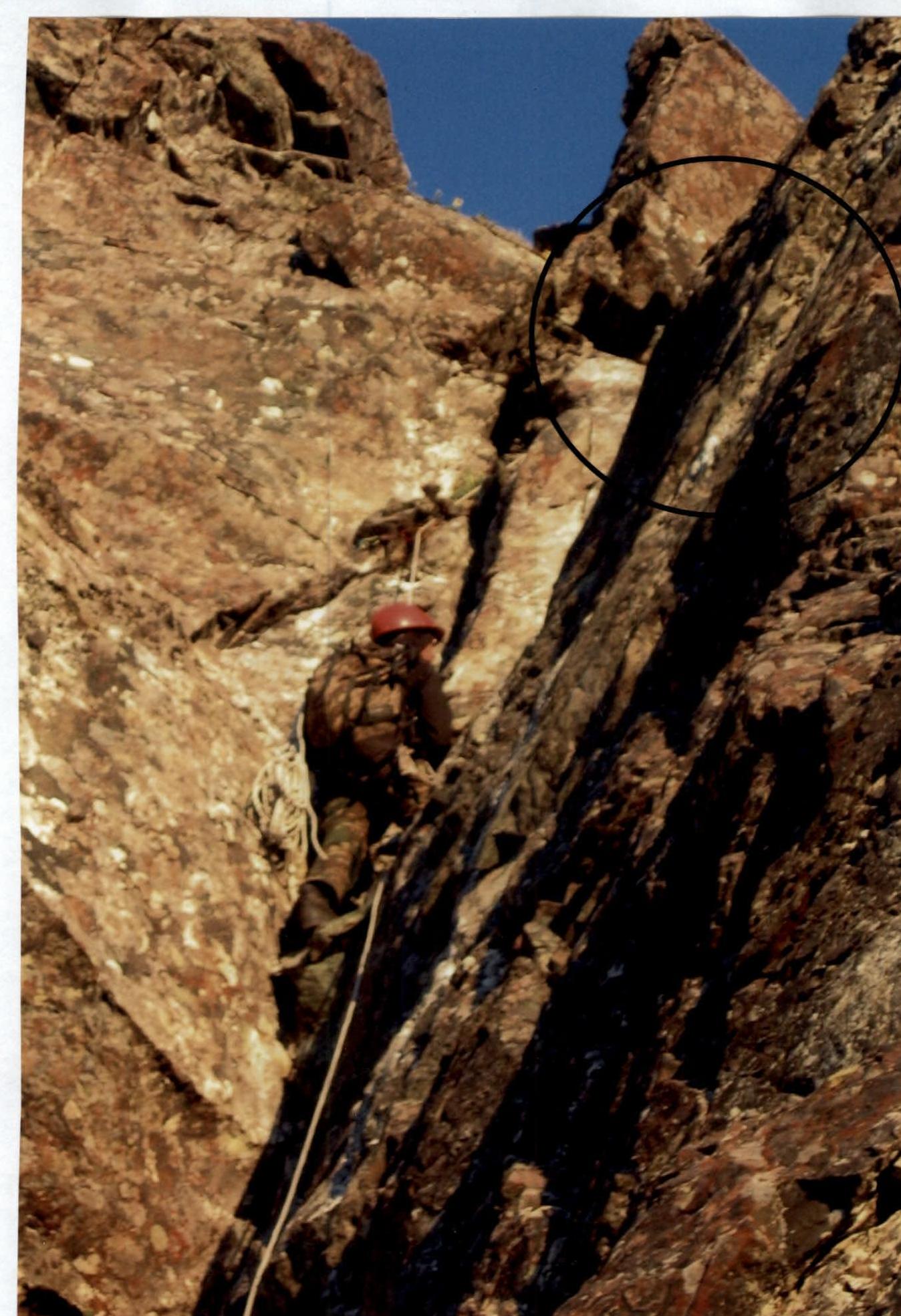
| | Length | Steepness | Difficulty | Pitons | Placements | Photo № | | :---: | :-------------: | :---------------------: | :-----------------------: | :-----: | :-------- | :--------: | :-----: | | R15 | | Cornice 1.5 m | 6 cat. dif. | IT | E4 | №9 | | R14 | 20 m | 90° | 5 cat. dif. | 6 | 8 | №6,7,8 | | R13 | 50 m | 40° | 2 cat. dif. | 0 | 0 | | | R12 | 50 m | 40° | 2 cat. dif. | 0 | 0 | №4 | | R11 | 70 m | 20° | 2 cat. dif. | 0 | 0 | | | R10 | 10 m | 75° | 4 cat. dif. | | 3 | | | R9 | 35 m | 15° | 1, 2 cat. dif. | 0 | 0 | | | R8 | 20 m | Cornice 95°, 0.5 m, 65° | 5 cat. dif. | IT | 6 | №3,4 | | R7 | 20 m | 45° | 2 cat. dif. | 0 | 3 | | | R6 | 20 m | 80° | 4 cat. dif. | 3 | 8 | | | R5 | 30 m | 35–45° | 2, 3 cat. dif. | 0 | 8 | | | R4 | 15 m | 90° | 5 cat. dif. | 3 | 5 | №1,2 |
Technical Description for the Ascent Scheme in UIAA Signs
R0 — base camp in the larch oasis of the Nyrdvomen-Shor river.
R0–R1 — base camp – crossing the Nyrdvomen-Shor river.
Crossing the Nyrdvomen-Shor river ford (depth 40–60 cm, during the period of abundant snowmelt, organization of rope belay is required). Section length — 500 m, steepness — 10°. Difficulty level — non-categorized.
R1–R2 — bypassing the green bald mountain and approaching the rock island.
Mountain tundra, rocky fields. Section length — 3000 m. Section steepness: initially 30–45°, in the upper part 45–50°. Difficulty level — non-categorized.
R2–R3 — traversing the rock walls and ascending to the green scree above the rock island to two red stones.
Large-block scree, snow. Section length — 400 m. Section steepness — 45–50°. Difficulty level — 1. Belay during movement across large rock blocks — gymnastic.
R3–R4 — traversing the rock walls and approaching the start of the technical part of the route.
Large-block scree, snow. Section length — 100 m. Section steepness — 45–50°. Difficulty level — 1. Belay during movement across large rock blocks — gymnastic. Under the rock massif of the bastion — a cairn marking the start of the route.
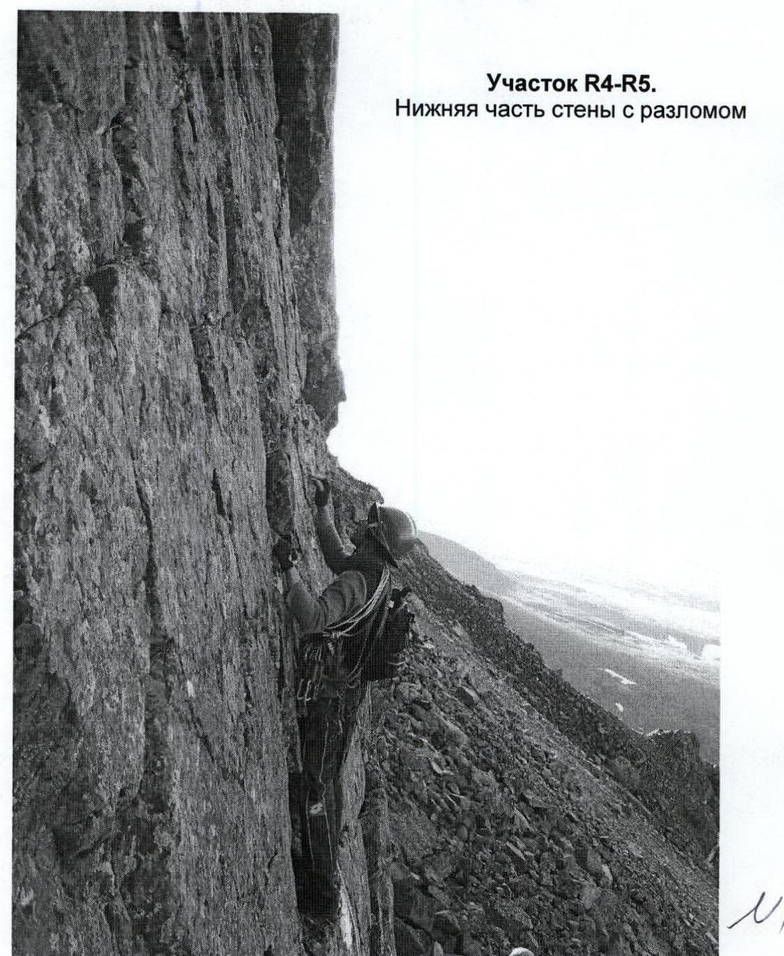
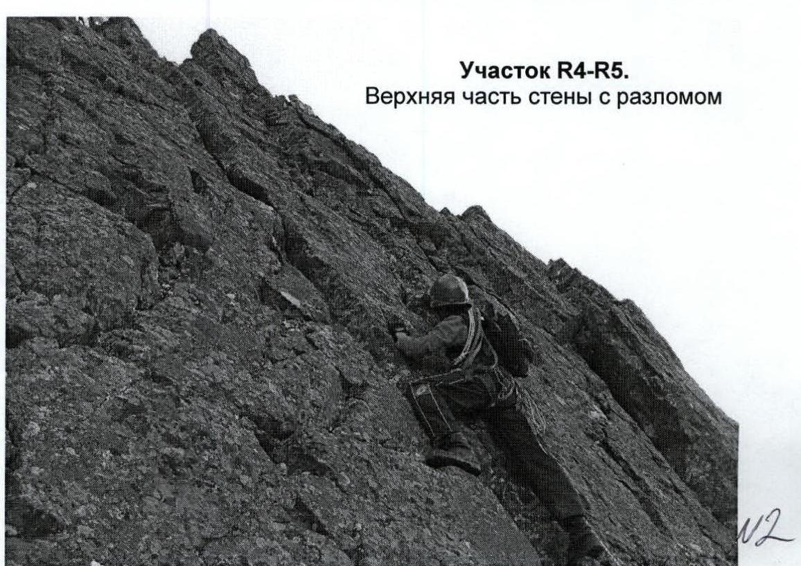
R4–R5 — passing the inclined wall with a cleft.
Rocks. Convenient handholds and footholds, abundant cracks and fractures for organizing belay points. In the center of the wall — a well-defined diagonal cleft. Section length — 15 m. Steepness — 90°. Difficulty level — 5. Belay — alternate. Intermediate belay points — pitons and placement elements.
R5–R6 — passing the ridge to the wall between the cornices.
Jagged rock ridge. Section length — 30 m. Section steepness — 35–45°. Difficulty level — 2, 3. Belay — alternate. For organizing intermediate belay points, loops were used, thrown over ridge outcrops. Mandatory quickdraws to reduce friction. Movement of participants — alternate.
R6–R7 — passing the wall between the cornices and exiting to a weakly expressed rock ridge.
Rocks. Section length — 20 m. Section steepness — 80°. Difficulty level — 4. Group movement with alternate belay. Intermediate points — placement elements.
R7–R8 — approaching along a weakly expressed ridge under the internal angle with a cleft.
Weakly expressed rock ridge. Section length — 20 m. Section steepness — 45°. Difficulty level — 2. Movement — alternate. Organization of intermediate belay points through outcrops, using loops and placement elements of various sizes.
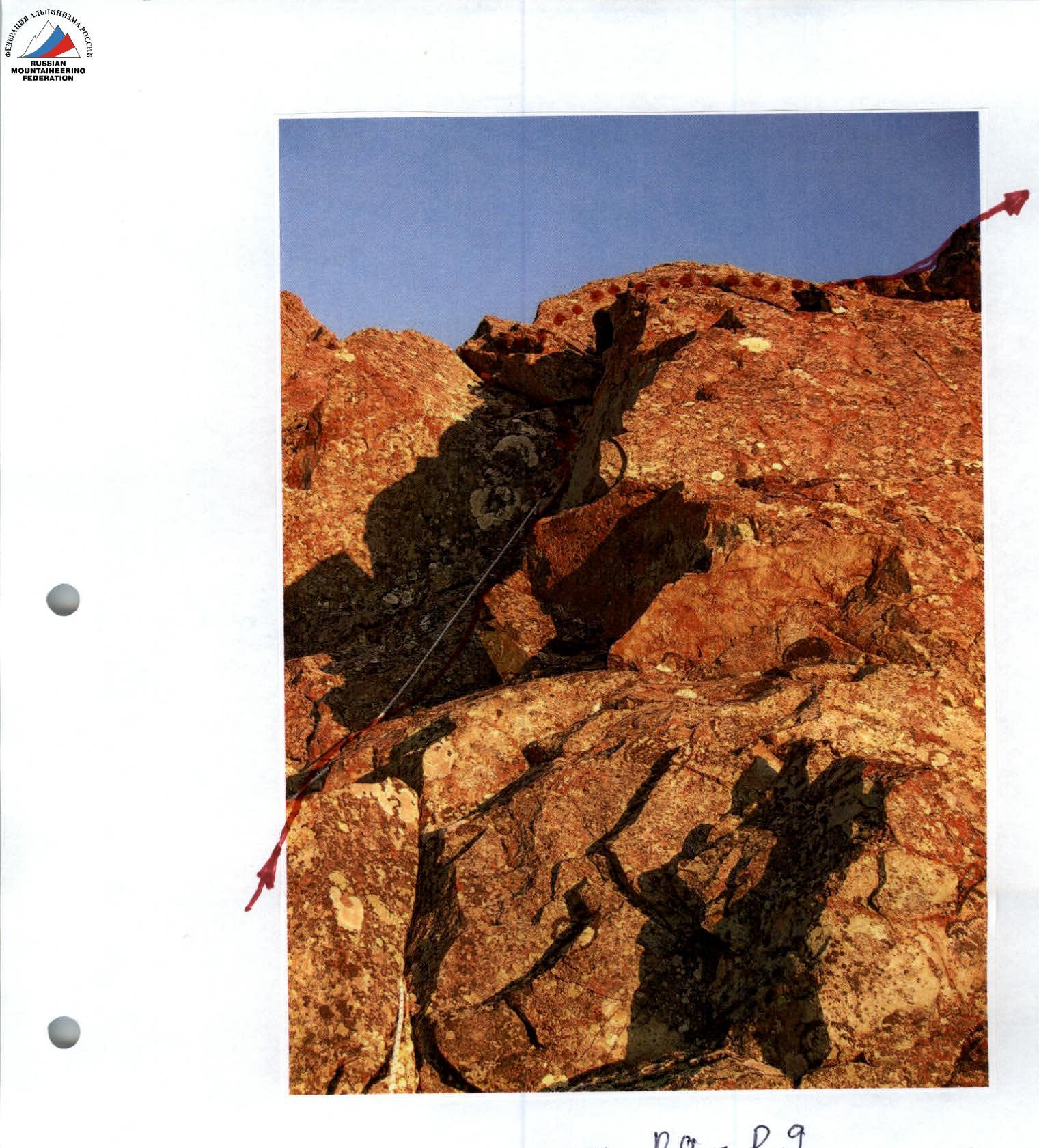
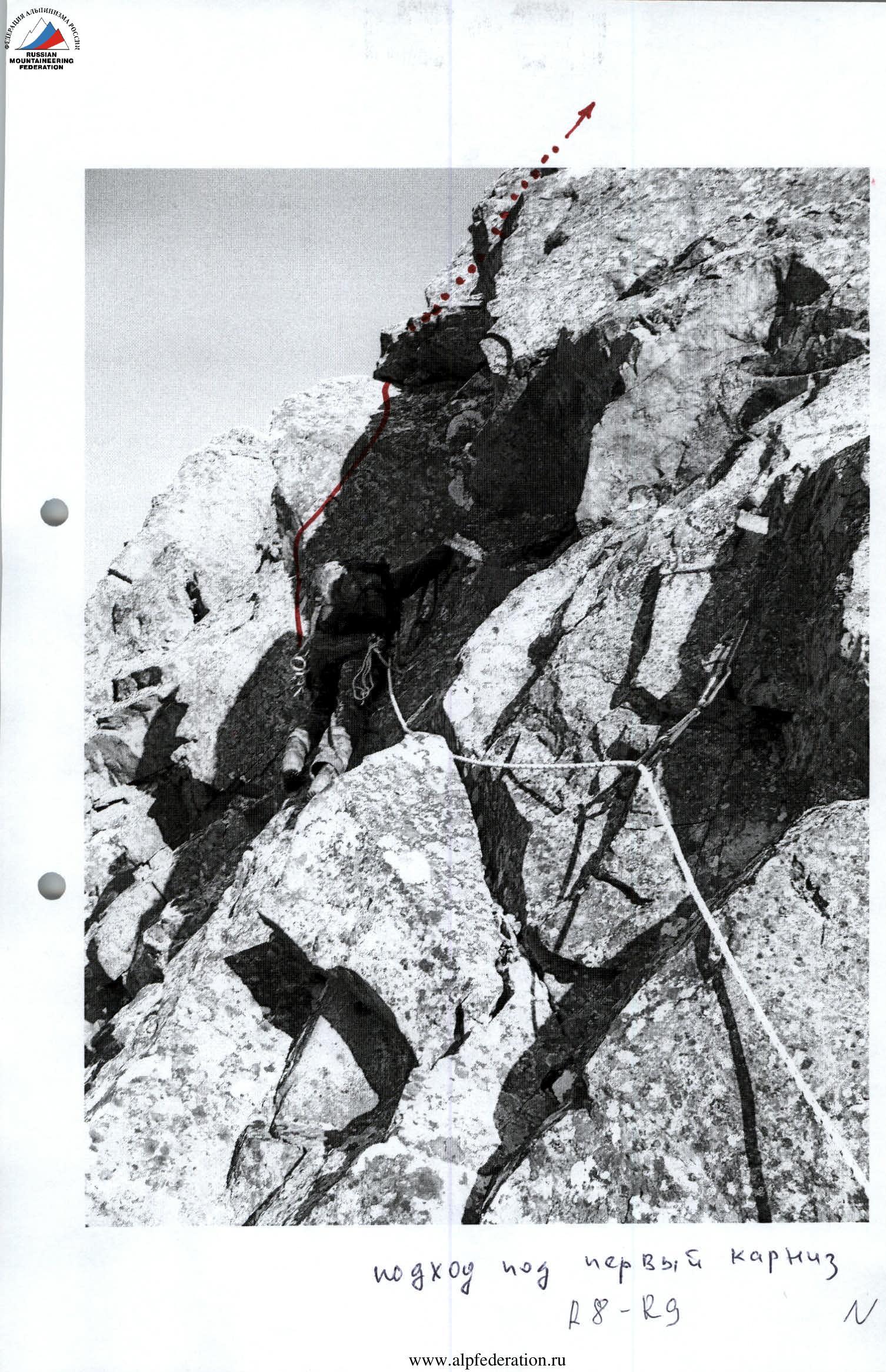
R8–R9 — passing the first internal angle with a cornice.
Monolithic rocks. Minimal number of cracks and fractures for pitons and placement elements. Organization of intermediate belay points is complicated. In the upper part — a cornice. Psychologically challenging section for the first climber. The cornice is small, 0.5 m, and is passed using two artificial points. Ladders are secured on placement elements in the cleft of the internal angle. Section length — 20 m. Section steepness — 65°. Cornice — 95°. Difficulty level — 5. When passing the cornice — 5.
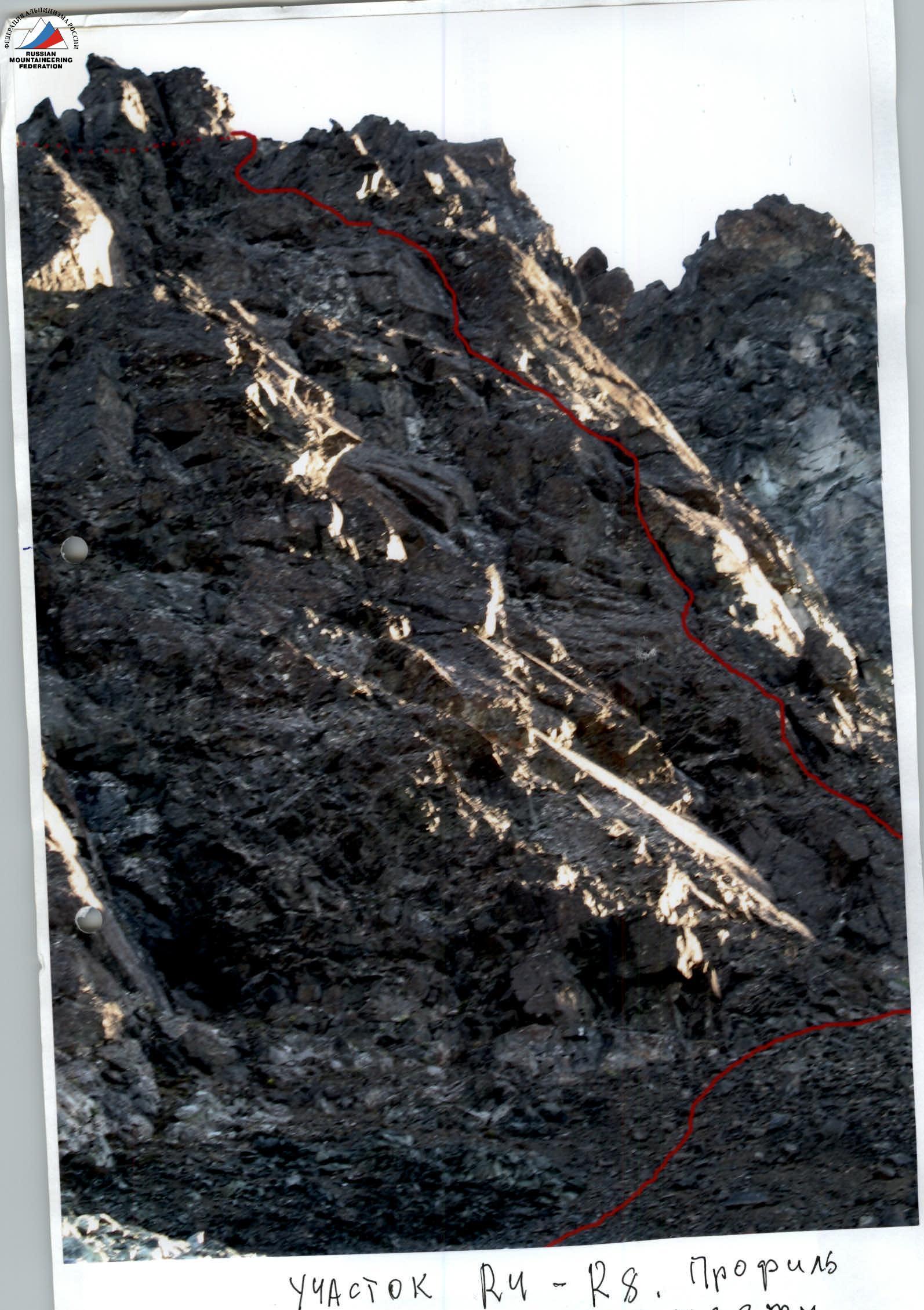
R9–R10 — passing the large-block rock ridge to the wall with diagonal cracks.
Rock ridge. Length — 35 m. Steepness — 15°. Difficulty level — 2. Belay organization through outcrops, loops on outcrops. Movement — alternate.
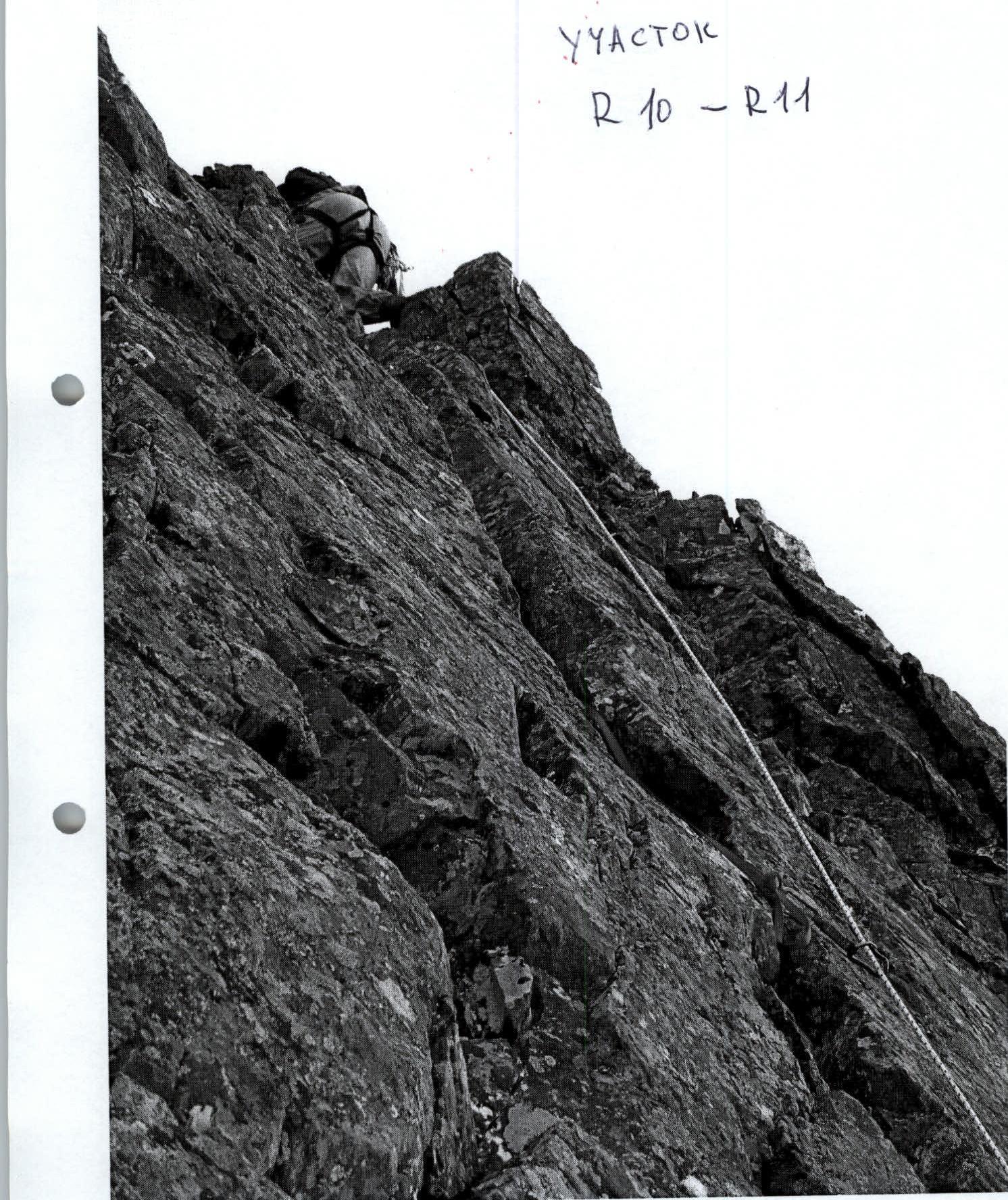
R10–R11 — passing the wall with diagonal cracks.
Rocks. Section length — 10 m. Steepness — 75°. Difficulty level — 4. Organization of intermediate belay points — pitons. Placement elements. Movement — alternate, in the upper part — simultaneous.
R11–R12 — traversing the jagged rock ridge with a series of "gendarmerie".
Rock ledges and small walls to the right of the ridge. Section length — 70 m. Steepness — 20°. Difficulty level — 2. Movement — alternate.
R12–R13 — passing a series of small ledges and walls.
Rock slabs. Stones and stone blocks on the slabs (subjective rockfall danger!). Length — 50 m. Steepness — 40°. Difficulty level — 2. Movement — alternate.
R13–R14 — passing the rock ridge, approaching the second internal angle with a cornice.
Jagged rock ridge. Organization of belay by laying the rope around outcrops. Easy climbing. Movement — alternate. Length — 50 m. Steepness — 30–40°. Difficulty level — 2.
R14–R15 — passing the second internal angle with a cornice — the key to the route, exiting to the junction of the rock ridges.
Glazed monolithic rocks. In the upper part — a rock cornice. Movement with a leader, team — on ropes. Section length — 20 m. Steepness — 85–90°. In the upper part — 95°. Overhang 1.5 m. Passed using artificial points of support, organized with the help of pitons and placement elements. Difficulty level — 5. In the upper part, when passing the cornice — 6.
R15–R16 — passing the rock ridge and reaching the summit.
Jagged, flattening towards the summit rock ridge. Easy climbing. Simultaneous movement on a shortened rope. Length — 150 m. Steepness — 15–0°. Difficulty level — 1, N/K.
R16 — summit 1060 (Dinozavr Eastern).
R16–R0 — descent along the center of the eastern slope.
Scree, snow. Crossing the Nyrdvomen-Shor river over snow bridges (snow bridges in summer are subjectively dangerous!). All-terrain vehicle road through the mountain tundra. Section length — 4–5 km. Difficulty level — in the upper part — 1, in the lower part — non-categorized.
Photographs of Sections
Section R4–R5:
- Lower part of the wall with fracture
Section R8–R9: first cornice
R12–R13
Section R14–R15: key, upper cornice
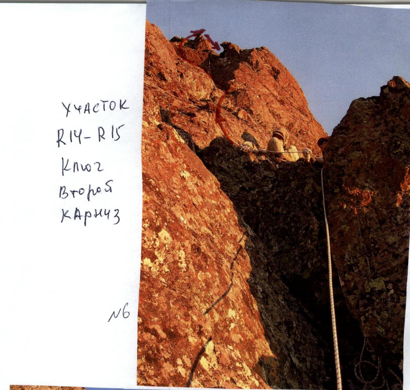
Cat. dif. — second. Cornice.