Ascent Passport
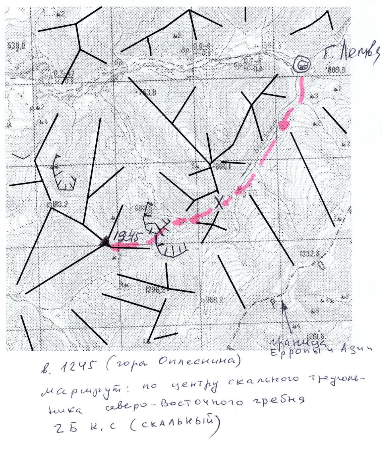
Area — Subpolar Urals. Ridge — Narod-Ityinsky Ridge (kряж). Valley — Bolshaya Lemva River Valley. Mountain massif — Lemva mountain node. Section number according to KMGV-2001 — #8 "Other mountain systems, massifs". Peak name — 1245 (Babikova Peak). Height — 1245 m. Route name — through the center of the rocky triangle of the north-eastern ridge.
First ascent. Proposed category of complexity for inclusion in the KMGV of the Climbing Federation of Russia — 2B category (rocky).
Note: The Climbing Federation of the Komi Republic requests the classification commission of the FAR to certify the ascent as 3A category for the group of first ascenders.
Height difference — 675 m. Route length — 3000 m. Average steepness of the main (technical part) of the route — 70°. Average steepness of the entire route — 55°. Technically difficult sections:
- 3rd category sections — 7 sections
- 4th, 5th, and higher category sections — none
No pitons were left on the route. Time taken by the team for the ascent:
- Approach to the base camp (conserved geologists' base "Lemva") from the miners' settlement Pachtvoz — 2 days
- Ascent from the base camp — 14 hours.
Leader: Maltsev S. L. (1st sports category, instructor 3rd category, certificate # 299, Ukhta)
Participants:
- Toropov V. A. (3rd sports category, Syktyvkar)
- Gaynerth P. S. (3rd sports category, Syktyvkar)
- Ivonina I. V. (3rd sports category, Syktyvkar)
Coach: Zhuravlev Sergey Vasilyevich (Master of Sports, instructor 2nd category, certificate # 1124, Syktyvkar)
Senior coach-supervisor: Fomenko Felix Nikolayevich (Master of Sports, instructor 1st category, certificate # 7, Ukhta)
Departure for the route — 7:00 AM, August 14, 2006. Reaching the summit — 3:45 PM, August 14, 2006. Return to the base camp — 7:00 PM, August 14, 2006.
Climbing event: Volunteer youth scientific and sports climbing expedition "Heights of the Native Land-2006", dedicated to the 85th anniversary of the statehood of the Komi Republic.
Executors:
- S. L. Maltsev
- S. V. Zhuravlev
- P. S. Gaynerth
Contact addresses: Syktyvkar, 167000, Internatsionalnaya St., 97, apt. 12. Phone: 8 (8212) 24–24–91. E-mail: Zhur58@rambler.ru
Climbing Federation of the Komi Republic NP "Sauk-Pai North Travel Club" Club of Tourists and Climbers of Ukhta
Report on the First Ascent
Mountain area: Subpolar Urals
Valley: Bolshaya Lemva River Valley
Ridge: Narod-Ityinsky Ridge (kряж)
Mountain massif: Lemva mountain node
Peak: 1245 m (Babikova Peak)
Route:
- through the center of the rocky triangle
- of the north-eastern ridge
Proposed category of complexity for inclusion in the KMGV of the Climbing Federation of Russia: 2B (rocky)
(The group that made the first ascent is proposed to be certified for 3A category.)
Leader — instructor SP-1: Maltsev Sergey Leonidovich. Date of the ascent: August 14, 2006. Climbing event: Volunteer youth scientific and sports climbing expedition "Heights of the Native Land-2006", dedicated to the 85th anniversary of the statehood of the Komi Republic.
Senior coach-supervisor
- Climbing Federation of the Komi Republic Fomenko F. N. (Master of Sports, instructor 1st category — certificate # 7, Ukhta)
- Deputy for safety (head of rescue) Climbing Federation of the Komi Republic Zhuravlev S. V. (Master of Sports, instructor 2nd category — certificate # 1124, badge # 6190, Syktyvkar)
Report prepared by: expedition leader: Zhuravlev Sergey Vasilyevich
Address: 167000, Syktyvkar, Internatsionalnaya St., 97, apt. 12.
Phone (8212) 24–24–91 (home),
E-mail: Zhur58@rambler.ru
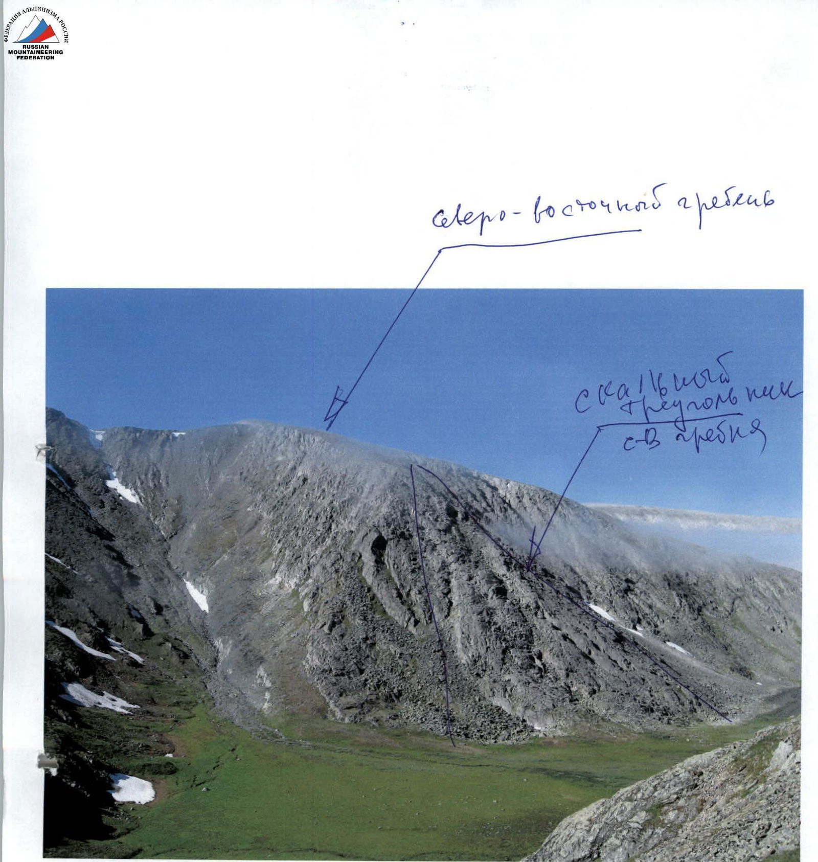
Peak 1245 (Babikova Peak)
 rocky triangle of the north-eastern ridge of peak 1245 (Babikova Peak)
Recommendation
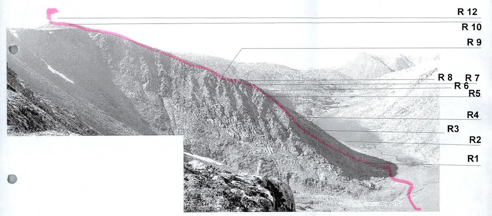
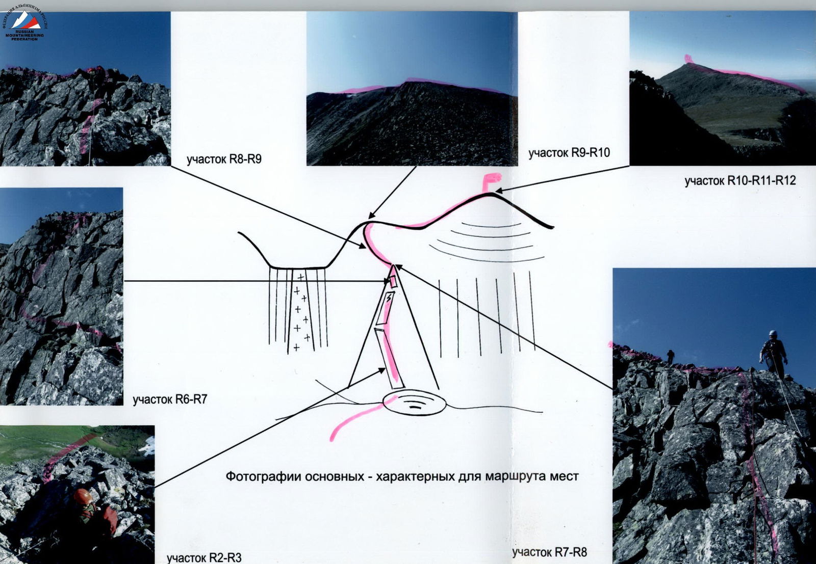
Section R8–R9
Section R9–R10
Section R10–R12
Section R6–R7
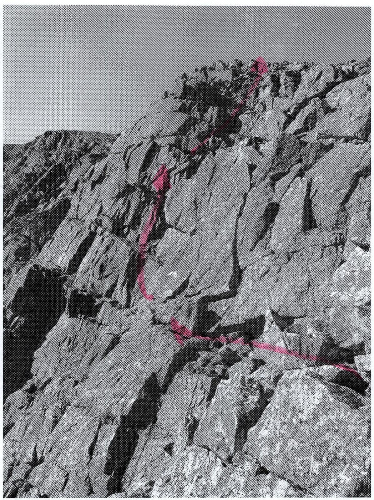
Photos of the main — characteristic places of the route
Section R2–R3
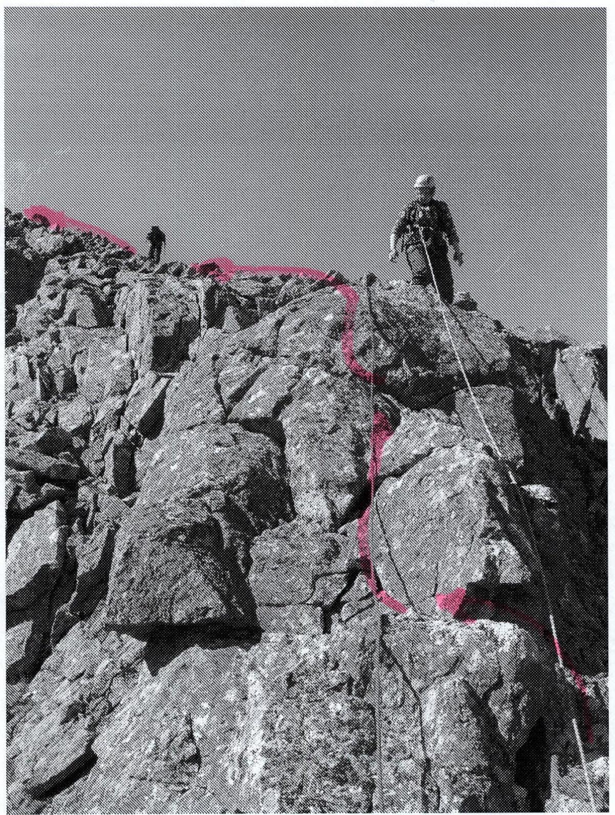
Section R7–R8
Description of the Peak
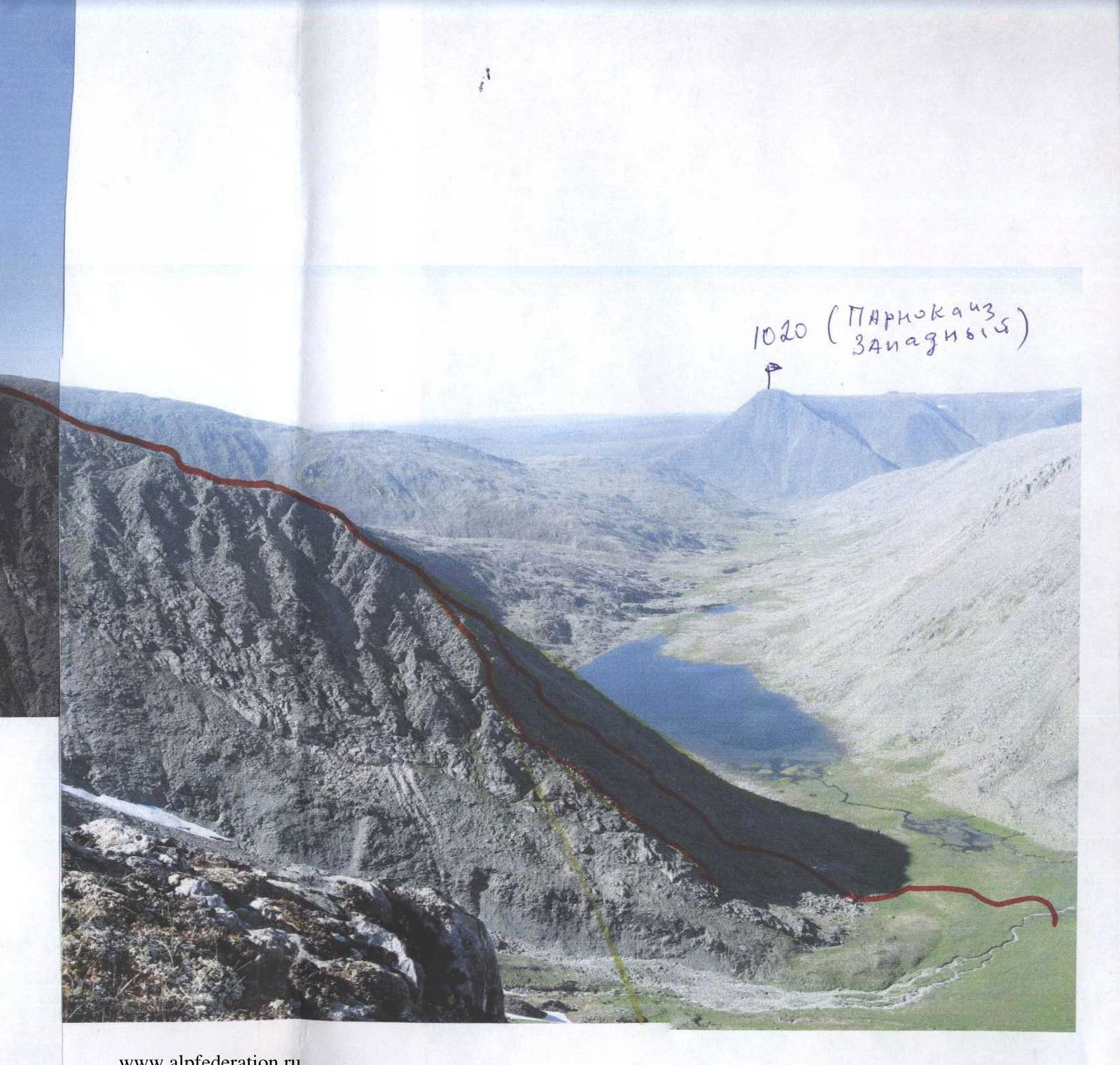
Peak 1245 (Babikova Peak) is located in the northern part of the Lemvaiz-Narod-Ityinsky Ridge (kряж) mountain node of the Subpolar Urals. Peak 1245 (Babikova Peak) is clearly visible from the crossing of the slopes of Maly Parnokaiz Peak from the Bolshaya Lemva River valley. The peak is a dome-shaped mountain of the goltsy type with characteristic steep rocky outcrops, ridges, and counterforts of the cirque type in the north-eastern and north-western exposure.
Peak 1245 (Babikova Peak) is shifted northwest from the main watershed ridge of the Subpolar Urals (section Lemvaiz Peak — Khaymaiz Peak) and north from the main mountain massif of the area — Lemvaiz.
The name of peak 1245 is not on the map. Ob River reindeer herders from the village of Saranpaul, who graze their herds in the summer period in the Bolshaya Lemva River valley, do not have a local name for this peak. The climbing name of this peak — Babikova Peak, was given by the sports group of first ascenders during the Volunteer youth scientific and sports expedition "Heights of the Native Land-2006". The name was given for ease of orientation.
Description of the Route
Approach: from the bivouac in the upper reaches of the Bolshaya Lemva River (conserved geologists' base "Lemva": 3 barracks + bathhouse) go up along the all-terrain road. The first crossing of a nameless stream is by wading or on stones. Then cross over the uval.
Uval — this is a scree-covered, overgrown with tundra vegetation ridge leading to the Main watershed ridge.
Further along the all-terrain road leading to the Ty kotlova River valley (eastern — Siberian slopes), reach the "confluence" (merger of two streams forming the Bolshaya Lemva River). In the area of the "confluence", cross to the left bank of the Bolshaya Lemva River by wading or on large stones.
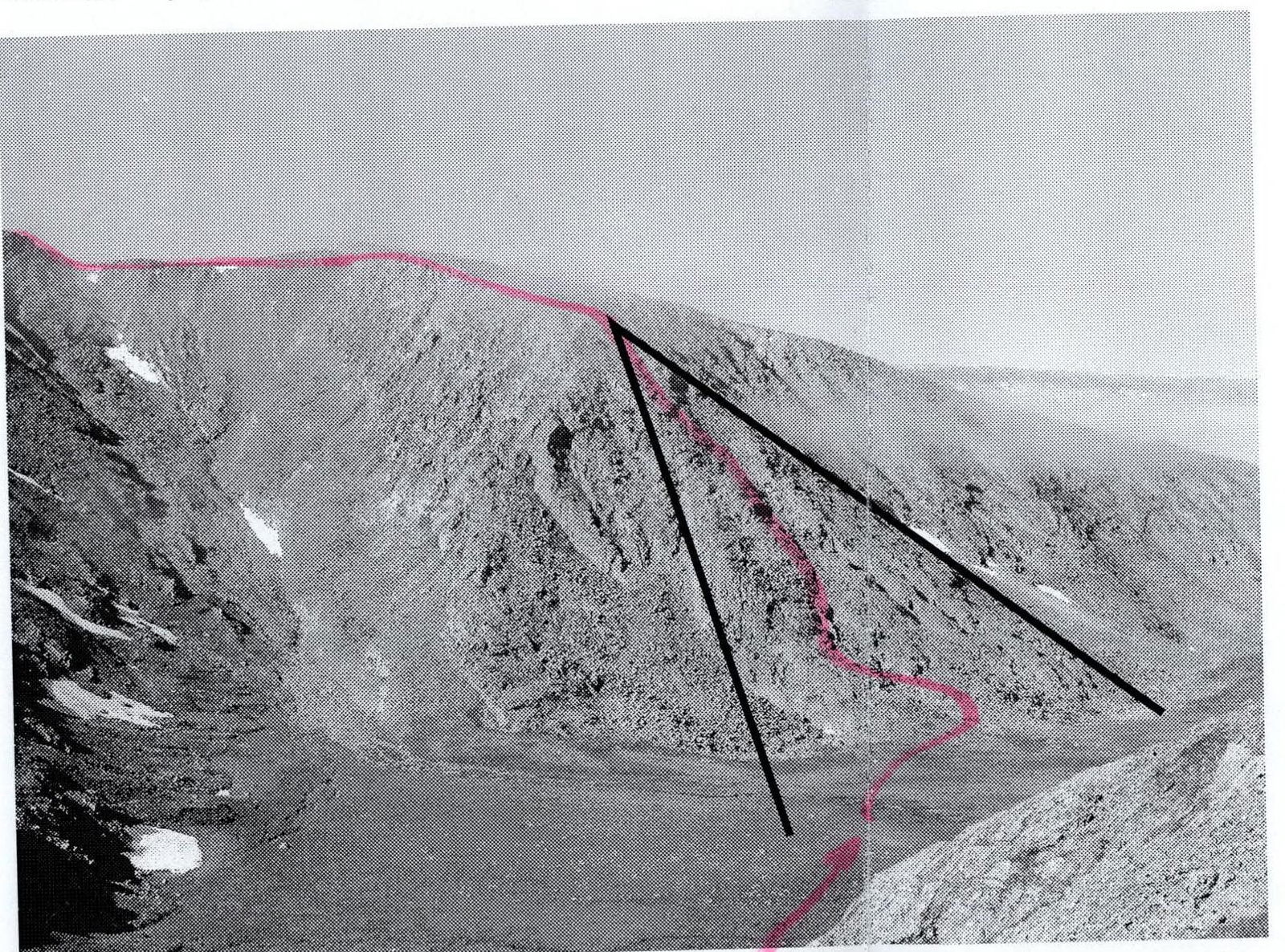
Then, along a weakly expressed geological trail, ascend to a nameless non-category pass. The landmark of the pass point is a characteristic rocky outlier on the left (see photo in the appendix).
Then descend from the pass down to the lake and, traversing the scree slopes along the lake, along the left bank, approach the start of the route.
Technical part of the route: the start of the route — a characteristic large-block scree leading to the rocky walls of the "triangle" of the north-eastern ridge. On the scree, it is convenient to organize rope teams.
The start of the technical part of the route is well expressed by a strip of dense, convenient for climbing slates. Further, after the strip of slates, move up the rocks — 350 m, sticking to the center of the rocky triangle. Insurance is alternate. Relief of the triangle:
- small walls
- oblique shelves
- inclined slabs with an abundance of cracks, ledges, reliable footholds
- reliable places for organizing insurance along the entire length of the rocky section
The key to the route — a 10-meter wall with a crack in the center in the upper part of the rocky triangle.
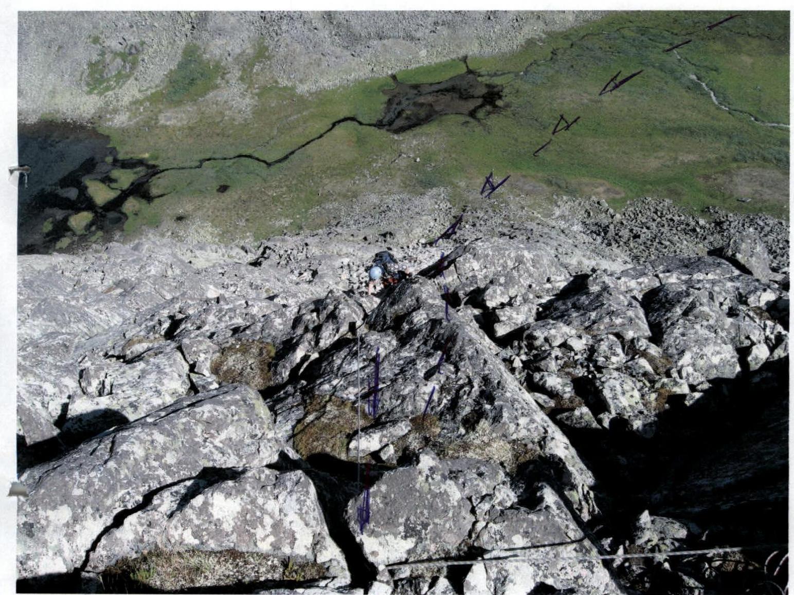
At the junction of the ribs of the "triangle" — the base of the north-eastern ridge. At the junction of the ribs, a control cairn is installed. From the control cairn along the ridge, about 30 m along simple rocks. Simultaneous movement in rope teams with organization of insurance by laying the rope around the ledges of the ridge.
Further:
- Exit to the base of the summit dome.
The ridge disappears, and the north-western slope of the peak begins, from which you need to ascend first to the subpeak (small scree dome), then from the subpeak (small scree dome) move along the scree slopes to peak 1245 (Babikova Peak).
Descent path:
- First, to the saddle between peak 1245 (Babikova Peak) and the nameless peak 1296.
- Then, traversing the northern slope of the nameless peak 1296, descend into the Bolshaya Lemva River valley, cross it by wading, and exit onto the all-terrain road.
- Along the all-terrain road, ascend to the uval and return to the base camp.
Equipment (for a sports group of 4 people):
- main rope 2 pcs. × 50 m
- rock hammer — 2 pcs.
- carabiners — 10 pcs.
- rock pitons — 5 pcs.
- chocks — 10 pcs. (full set of stoppers)
- quickdraws — 10 pcs.
- anchor loops — 6 pcs.
- stove (gas burner) — 1 pc.
- tent — 1 pc.
- radio station — 1 pc.
Scheme in UIAA signs
Peak 1245 (Babikova Peak)
Route: through the center of the rocky triangle of the north-eastern ridge
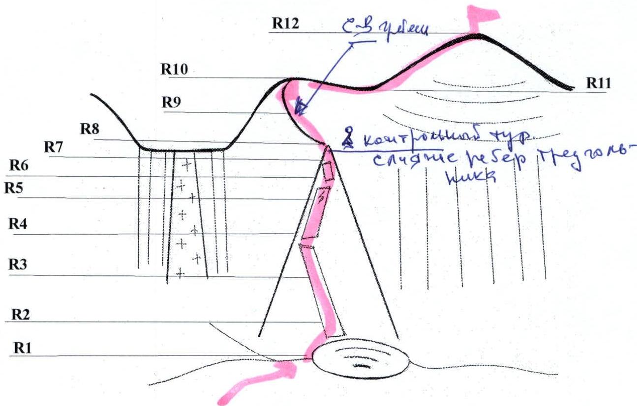
R0 — Bivouac in the upper reaches of the Bolshaya Lemva River (conserved geologists' base).
R0–R1 — Approach to the base of the eastern ridge at the lake, to the start of the route. Large-block and medium-block screes.
Screes, talus, moss. Length of the section — 3000 m. Steepness of the section — 15°. n/c.
R1–R2 — Passage of the slate strip. Rocks. Convenient handholds, convenient footholds. Total length of the section — 15 m, steepness — 60°, level of complexity — 2–3 cat. sl. Alternate insurance by laying the rope around ledges. In some places, chocks were used.
R2–R3 — Exit to the shelf. Dense slab-like rocks with good handholds and ledges. Total length of the section — 40 m, steepness — 50–60°, level of complexity — 3 cat. sl. Alternate movement, organization of insurance by laying the rope around ledges. In some places, chocks were used.
R3–R4 — Alternating rock walls 4–7 m. Rocks. Total length of the section — 40 m, steepness — 60–70°, level of complexity — 3 cat. sl. Alternate movement, organization of insurance by laying the rope around ledges. In some places, chocks were used.
R4–R5 — Alternating rock walls 4–7 m. Rocks. Total length of the section — 40 m, steepness — 60–70°, level of complexity — 3 cat. sl.
In the middle of the section is the key to the route: a wall, steepness — 70°, height — 10 m with a crack. Level of complexity of the key — 3 cat. sl.
Alternate movement, organization of insurance — by laying the rope around ledges. In some places, chocks were used. Movement on the key section — alternate, with securing the rope.
R5–R6 — Alternating rock walls 4–7 m. Rocks. Total length of the section — 40 m, steepness — 60–70°, level of complexity — 3 cat. sl. Alternate movement, organization of insurance by laying the rope around ledges. In some places, chocks were used.
R6–R7 — Alternating rock walls, inclined slabs, shelves. Rocks. Total length of the section — 40 m. Steepness — 60–70°. Level of complexity of the section — 3 cat. sl. Alternate movement, organization of insurance by laying the rope around ledges. In some places, chocks were used.
R7–R8 — Exit to the top of the rocky "triangle". Rocks. Total length of the section — 40 m, steepness — 60–70°, level of complexity — 2–2+ cat. sl. Simultaneous movement on a shortened rope. Alternate insurance, laying the rope around ledges.
At the confluence of the ribs of the rocky triangle, a control cairn.
R8–R9 — Passage of the rocky ridge. Rocks.
Total length of the section — 30 m, steepness — 30–40°, level of complexity — 2–2+ cat. sl.
The ridge is passed simultaneously. Alternate insurance, laying the rope around ledges.
R9–R10 — Movement to the subpeak (small scree dome).
Total length of the section — 400–500 m, steepness — 30°, level of complexity — 1– cat. sl.
Movement to the subpeak — simultaneous.
R10 —drainage between peak 1245 (Babikova Peak) and subpeak (small scree dome).
Total length of the section — 750 m, steepness — 15°, level of complexity — 1– cat. sl. Simultaneous movement along large fragment material.
R11–R12 — Exit to peak 1245 (Babikova Peak). Total length of the section — 600 m, steepness — 30°, level of complexity — 1 cat. sl. Simultaneous movement along large fragment material.
R12 — Peak 1245 (Babikova Peak). The peak is composed of large fragment material.
R12–R13 — Descent — through the subpeak (small scree dome). First, to the saddle between peak 1245 (Babikova Peak) and the nameless peak — 1296.
Total length of the section — 200 m, n/c.
R13–R14 — Traversing the northern slope of the nameless peak 1296 along large scree slopes.
Total length of the section — 200–350 m, steepness — 25–15°, level of complexity — n/c.
R14–R0 — Descent into the Bolshaya Lemva River valley, crossing, exit onto the all-terrain road, return to the base camp.
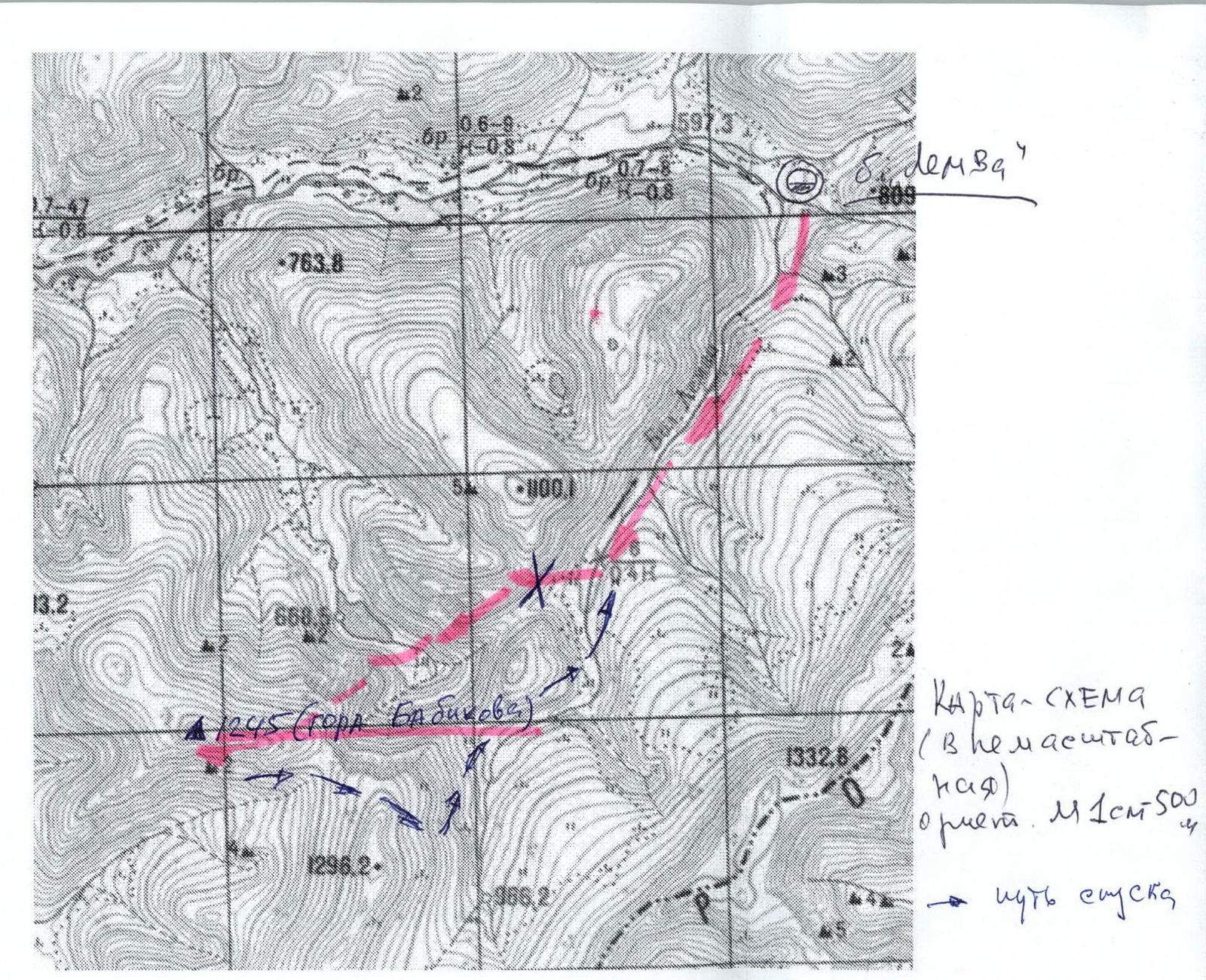
Map-scheme of the North-Western part of the Lemva mountain node (map-scheme is not to scale)
Section R7–R8