
Russian Championship in Alpinism
Technical Class 2019
REPORT
on the ascent to Tangra Tower (5820 m) via the southeast wall, 6B category of complexity — first ascent by a team from Krasnoyarsk Krai. July 30, 2019–August 2, 2019.
I. ASCENT DOCUMENTATION
| 1. General Information | ||
|---|---|---|
| 1.1 | Full name, sports rank of the team leader | Prokofyev D.E. (MS) |
| 1.2 | Full name, sports rank of team members | Popova M.E. (MS), Matyushin N.O. (CMS) |
| 1.3 | Full name of coach | Prokofyev D.E. (MS), Zakharov N.N. (HMS), Balezín V.V. (HMS) |
| 1.4 | Organization | Krasnoyarsk Regional Alpinism Federation |
| Characteristic of the ascent object | ||
| 2.1 | Region | Karakoram |
| 2.2 | Valley | Kkhan Valley |
| 2.3 | Section number according to the 2013 classification table | 10.2. |
| 2.4 | Name and height of the peak | Tangra Tower, 5820 m |
| 2.5 | Geographical coordinates of the peak (latitude/longitude), GPS coordinates | 35°20′18″N 76°27′23″E |
| 3. Route Characteristics | ||
| 3.1 | Route name | via southeast wall |
| 3.2 | Proposed category of complexity | 6B |
| 3.3 | Degree of route exploration | first ascent |
| 3.4 | Nature of route terrain | combined |
| 3.5 | Height difference on the route (altimeter or GPS data) | 850 m to the ridge |
| 3.6 | Route length (in meters) | 1375 m |
| 3.7 | Technical elements of the route (total length of sections by category of complexity, indicating terrain type: ice/snow, rock) | I category — no value m II category — 120 m III category — 15 m IV category rock — 120 m V category rock — 255 m VI category rock — 865 m Rock 6, A3 — 195 m Rock 6, A4 — 60 m |
| 3.8 | Average route slope, (°) | 75° |
| 3.9 | Average slope of the main route section, (°) | 84° |
| 3.10 | Descent from the summit | via the ascent route |
| 3.11 | Additional route characteristics | Practically no water available on the route |
| 4. Team Action Characteristics | ||
| 4.1 | Time in motion (team hours, indicated in hours and days) | 37 h 45 min, 3 days |
| 4.2 | Night halts | In a platform |
| 4.3 | Route processing time | 0 h, 0 days |
| 4.4 | Entering the route | July 30, 2019 at 5:00 |
| 4.5 | Reaching the summit | August 2, 2019 at 17:00 |
| 4.6 | Returning to base camp | August 3, 2019 at 17:00 |
| 5. Weather Conditions | ||
| 5.1 | Temperature, °C | 0–10 °C |
| 5.2 | Wind speed, m/s | 5 m/s |
| 5.3 | Precipitation | August 2, 2019. Snow, thunderstorm |
| 5.4 | Visibility, m | August 2, 2019. 50 m |
| 6. Report Responsible | ||
| 6.1 | Full name, e-mail | Prokofyev D.E., [email protected] |
II. ASCENT DESCRIPTION
1. Ascent Object Characteristics
1.1. General Peak Photo
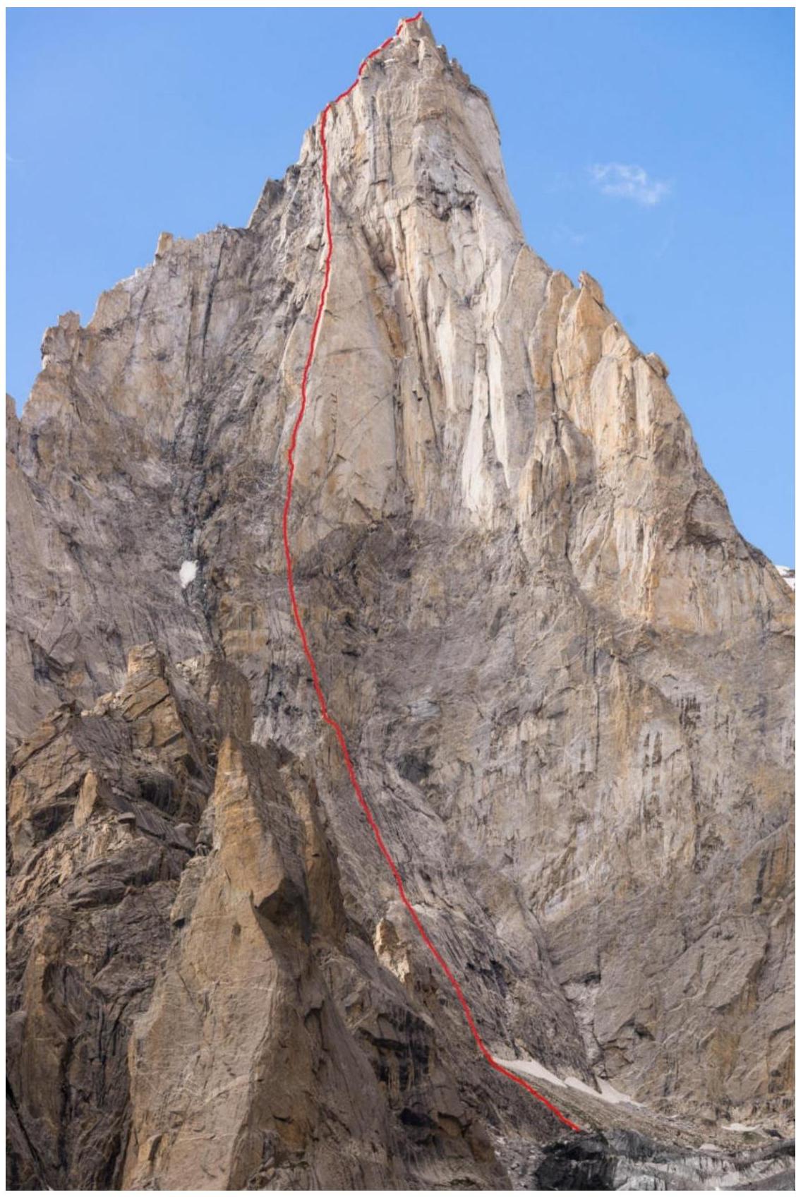
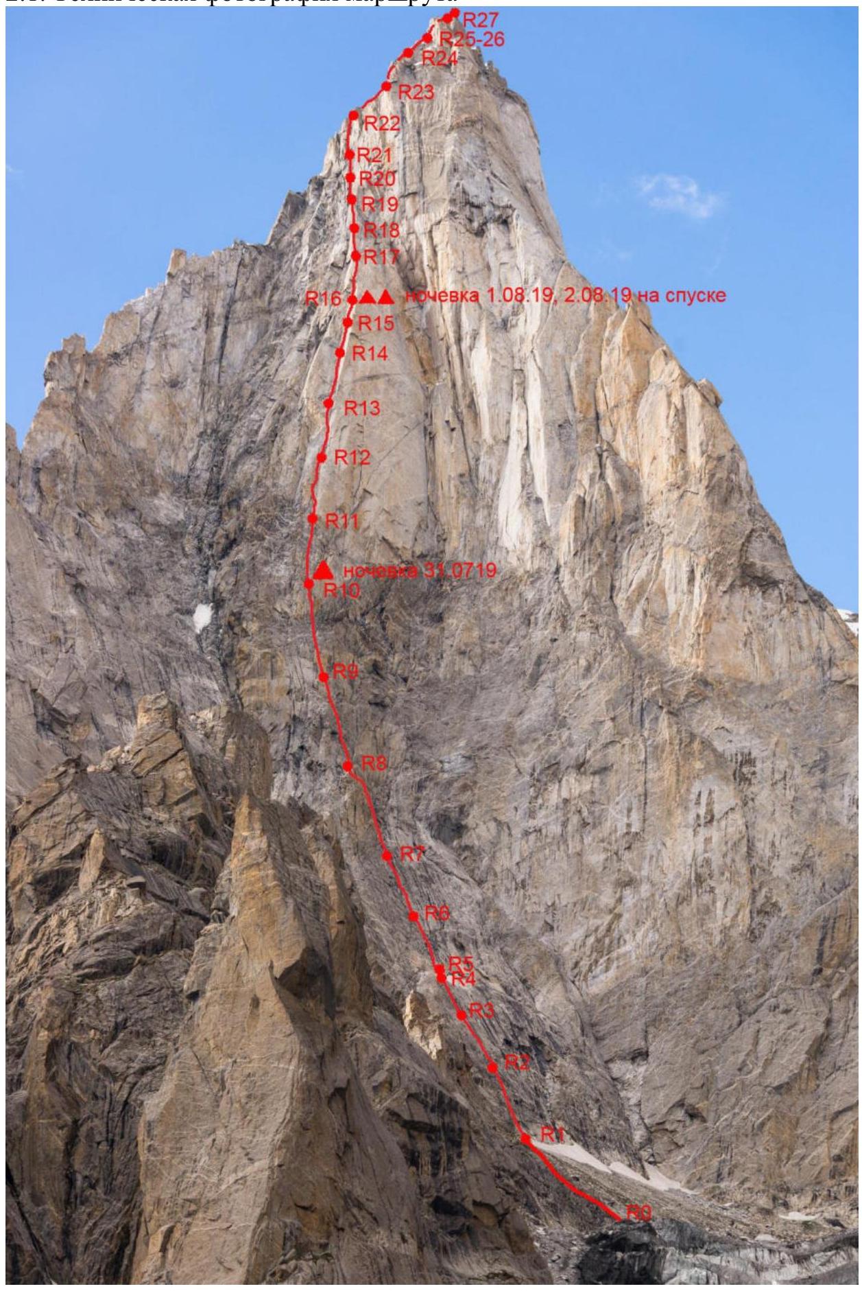
Route taken by the team.
1.2. Route Profile Photo
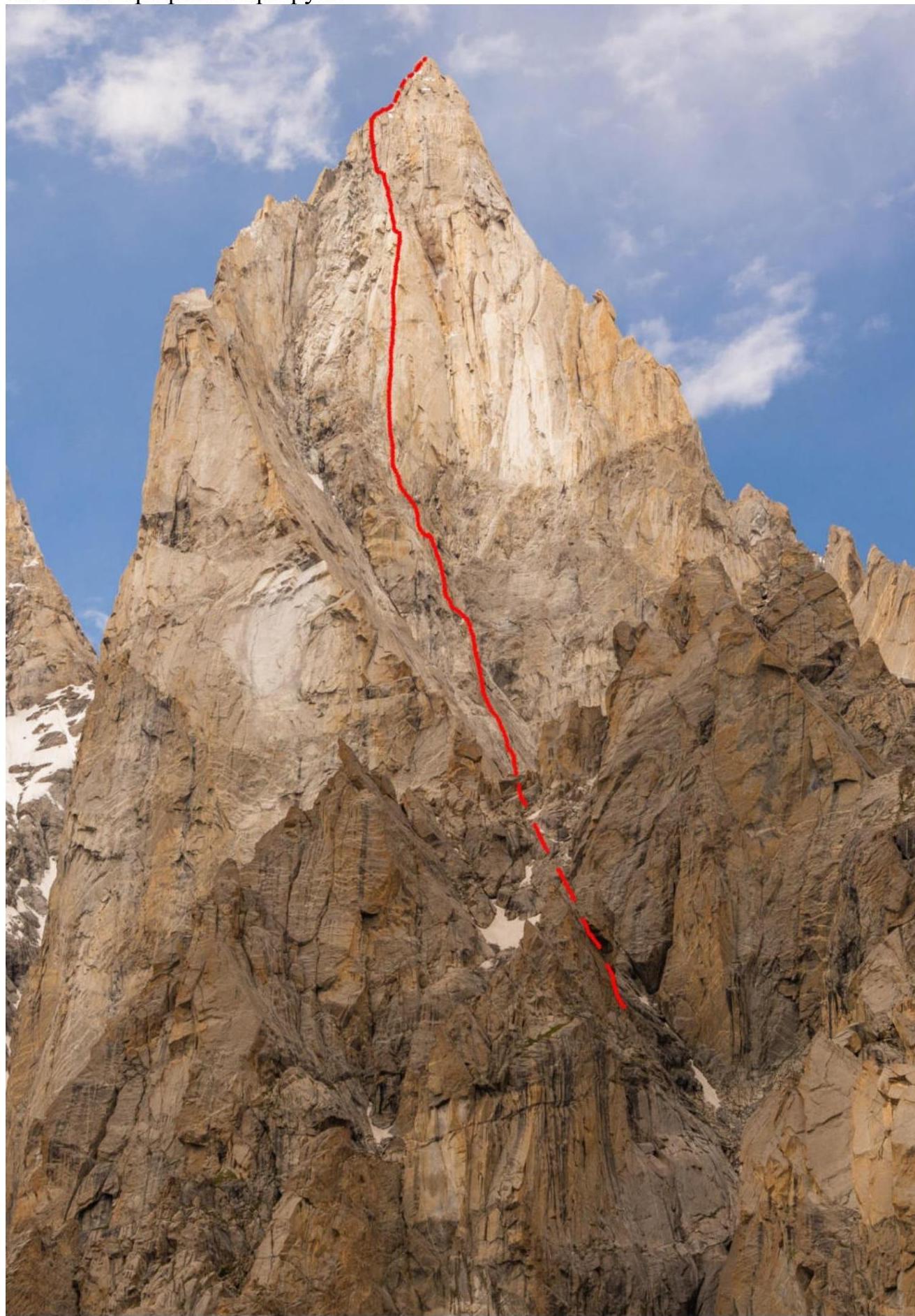
1.3. Drawn Route Profile
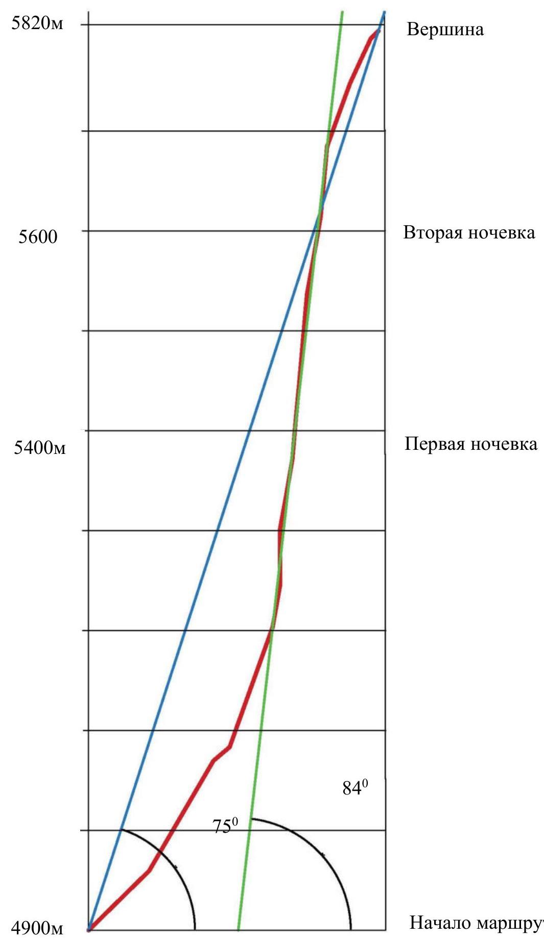
5820 m — Summit 5600 m — Second night halt 5400 m — First night halt 4900 m — Route start 75° 84°
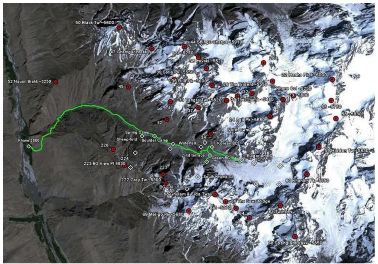
1.4. Area Photopanorama
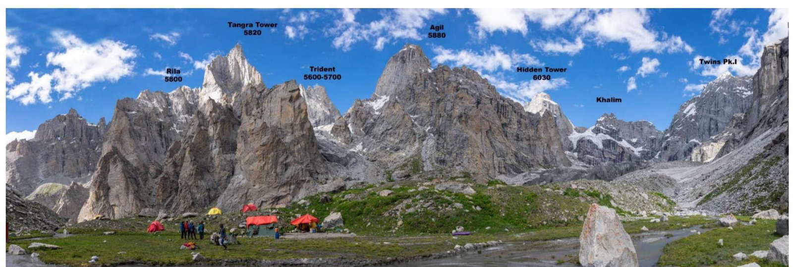
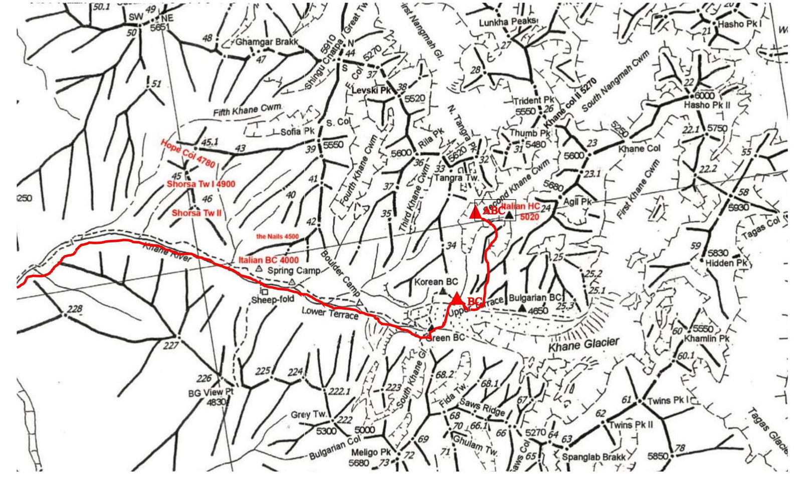
1.5. Area Map
The ascent area is geographically located in the Karakoram mountain range, country — Islamic Republic of Pakistan. It is a rarely visited mountain area. At the time of the expedition, several ascents were made by a Bulgarian team, and several failed attempts were made by other teams.
In particular, ascents were made to Levski peak 5733 m and Grey tower 5435 m. There was one failed attempt on Tangra Tower by a Canadian-English duo in 2015. There are still many peaks available for first ascents and first traverses in the area.
Access to the area is from Skardu towards the Hushe village. The journey is by car to Khane village, located at 2890 m above sea level, taking one day. Then, the approach to the base camp is up the mountain trail of the Kkhan valley. The height difference to the base camp is 1500 m, taking the team one day (10 hours) (without prior acclimatization, it's better to make the approach over two days). The base camp is located in the left pocket of the main Kkhan glacier, at an altitude of 4400 m. From the base camp to the start of the route takes 3–4 hours up the lateral Second Khan glacier to a height of 4850 m. The approach is via the right moraine, bypassing the icefall. There is a possibility to set up an advance camp on the glacier's "cushion" for making drops, acclimatization, and ascent. The height of the peaks in the area does not match the data on the terrain maps and exceeds them according to GPS data by approximately 200 m.
2. Route Characteristics
2.1. Technical Route Photo
2.3. Route Diagram in UIAA Symbols
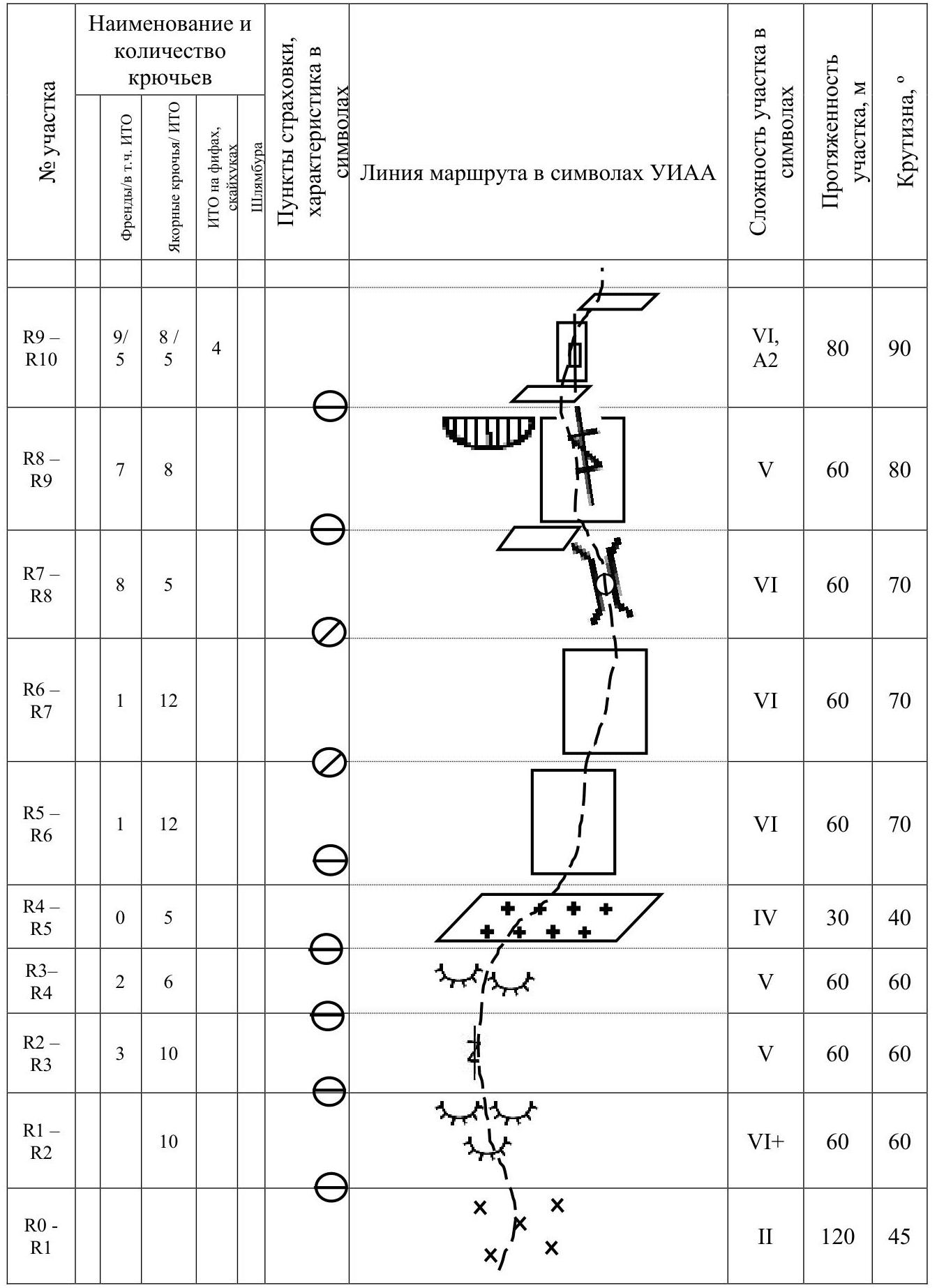
| Section | Friends/ incl. ITO | Anchor hooks/ ITO | ITO on cams, skyhooks | Bolts | Section complexity in symbols | Section length, m | Slope, ° |
|---|---|---|---|---|---|---|---|
| R0–R1 | 2 | 120 | 45 | ||||
| R1–R2 | 10 | 4+ | 60 | 60 | |||
| R2–R3 | 3 | 10 | 5 | 60 | 60 | ||
| R3–R4 | 2 | 6 | 5 | 60 | 60 | ||
| R4–R5 | 0 | 5 | 4 | 30 | 40 | ||
| R5–R6 | 1 | 12 | 6 | 60 | 70 | ||
| R6–R7 | 1 | 12 | 6 | 60 | 70 | ||
| R7–R8 | 8 | 5 | 6 | 60 | 70 | ||
| R8–R9 | 7 | 8 | 5 | 60 | 80 | ||
| R9–R10 | 9 | 8 | 5 | 4 | 6, A2 | 80 | 90 |
| R10–R11 | 8 | 10 | 7 | 6, A2 | 50 | 80 | |
| R11–R12 | 8 | 12 | 11 | 2 | 6, A2 | 50 | 80 |
| R12–R13 | 8 | 10 | 10 | 1 | 6, A2+ | 60 | 85 |
| R13–R14 | 5 | 12 | 12 | 1 | 6, A3 | 45 | 85 |
| R14–R15 | 3 | 12 | 12 | 1 | 6, A3 | 40 | 85 |
| R15–R16 | 4 | 8 | 8 | 2 | 6, A3 | 30 | 85 |
| R16–R17 | 0 | 17 | 17 | 1 | 6+, A3–A4 | 60 | 85 |
| R17–R18 | 6 | 10 | 10 | 6, A2 | 40 | 80 | |
| R18–R19 | 4 | 12 | 11 | 6, A3 | 40 | 80 | |
| R19–R20 | 4 | 8 | 6 | 6, A2 | 30 | 80 | |
| R20–R21 | 8 | 13 | 10 | 2 | 6, A2–A3 | 40 | 85 |
| R21–R22 | 8 | 10 | 7 | 1 | 6, A2+ | 60 | 85 |
| R22–R23 | 3 | 12 | 4 | 55 | 70 | ||
| R23–R24 | 3 | 7 | 5+ | 40 | 70 | ||
| R24–R25 | 1 | 8 | 8 | 4, A2 | 35 | 65 | |
| R25–R26 | 2 | 9 | 9 | 5, A2 | 35 | 65 | |
| R26–R27 | 3 | 3 | 15 | 45 |
3. Team Action Characteristics
3.1 Brief Description of Route Passage
Since the ascent area implied heights up to 6000 m, the team conducted a preliminary acclimatization ascent to Elbrus (5642 m) (reached the summit on July 8) with several nights at 4200 m and 4800 m. On July 16, 2019, the team arrived in the area and set up a base camp at 4440 m near the Kkhan glacier.
Several exits were made to heights of 5000 m and 5500 m with overnight stays to scout approaches to the route, drop equipment, and for additional acclimatization.
As a result, the team chose a line for ascending Tangra Tower (5820 m) via a logical and relatively safe route.
The start of the ascent to the base of the southeast wall is near the camp on a convenient meadow in the moraine pocket of the glacier, making it attractive for ascents.
The Tangra Tower peak stands out among all peaks in the area with its beauty. The peak is an acute pinnacle dominating the entire valley.
No successful ascents to this mountain were made before our team, so the exact height was unknown. There was one attempt by an English-Canadian duo in 2015, but they only managed to climb half the route in four days before descending due to the complexity of the terrain.
The choice of route was obvious for us. We followed the safest and most vertical line where we could quickly pass the base of the route and reach the vertical section ("headwall"). The vertical section is highlighted by a counterfort from the wall, making it safe.
The ascent needed to be very fast due to the short weather windows in late July and the team's limited carrying capacity.
Since the team consisted of only three people, with one being a female, we had to minimize the load. We took to the wall: — 3 ropes; — a set of equipment; — 6 liters of water; — gas; — food; — a suspended platform for setting up a bivouac.
For the route, we used a scheme developed by the Krasnoyarsk alpinism team, involving simultaneous protection while traversing complex mountain terrain. This method allows for faster passage of large walls.
The first person climbs with two ropes, creates stations every 30 m, and continues climbing. The second person follows on the fixed static rope, simultaneously protecting the first with a Grigri device. The second person reaches the station, takes in the third, and the process continues. This method is safer and faster.
July 30, 2019. On the first day, Prokofyev Denis led, maximizing free climbing (up to 7A+). He managed to climb 500 m of the wall, reaching a small snowpatch, significantly easing the team's further progress.
The general direction was chosen towards a large internal angle leading to the summit pinnacle. This angle is on a protruding part of the wall, making it safe from falling rocks.
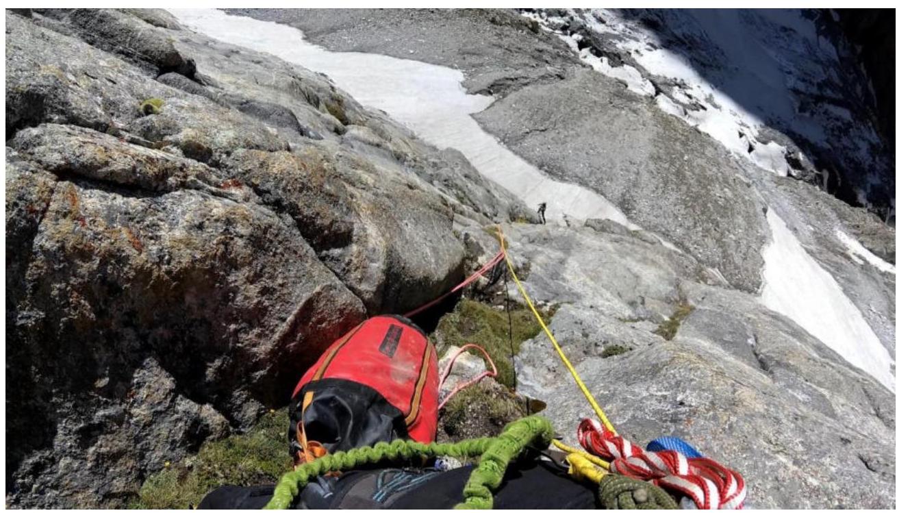
Photo 1. Section R0–R2, taken from station R2.
The ascent description continues in detail, describing the terrain, difficulties, and equipment used for each section of the route.
The team reached the summit on August 2, 2019, at 17:00.
Conclusion
The route was completed by the team without prior processing in 4 days: — 3 days climbing upwards; — 1 day for descent. The passage was made in a modern, fast style with simultaneous protection, significantly increasing the team's speed on the technically complex route. Using a classical alternating scheme would have taken at least 4–5 days.
Bolts on the route were used only for setting up a platform and descending via the ascent route.
Overnight halts were organized in a suspended platform, a modern big wall climbing style that saves weight and increases the speed of passing complex sections.
The southwest wall of the peak is promising for subsequent alpinist ascents, with the possibility of laying out several complex and logical lines.
Denis Prokofyev has experience with two 6B ascents (including on Aksu) and about 18 6A category ascents, including first ascents as a leader.
Marina Popova has experience with one 6B and nine 6A category routes.
We believe that, based on technical complexity and height, the route corresponds to the 6B category.
The high speed of work on the route is due to: — excellent acclimatization of the team; — systematic, continuous technical preparation for the ascent throughout the year; — accurate timing to catch the "weather window"; — using a scheme with simultaneous protection.

Comments
Sign in to leave a comment