Passport
- High-altitude category.
- Central Himalayas, Southern spur of the Main Himalayan Range between Lhotse and Makalu.
- Peak Baruntse via the center of the Western wall (7220 m).
- 6B category of difficulty, first ascent.
- Elevation gain: 1320 m, wall length to the ridge — 1385 m, ridge length — 300 m. Length of sections with 6A–6B category of difficulty — 735 m. Average slope of the route — 55°. Average slope of the wall section (bergschrund to South Summit) — 61° (5900–7100 m).
- Used previously driven pitons and not removed — 0.
| Rock | Chocks | Ice | Snow |
|---|---|---|---|
| 55 | 112 | 34 | 20 |
| 8 | 5 | 0 | 0 |
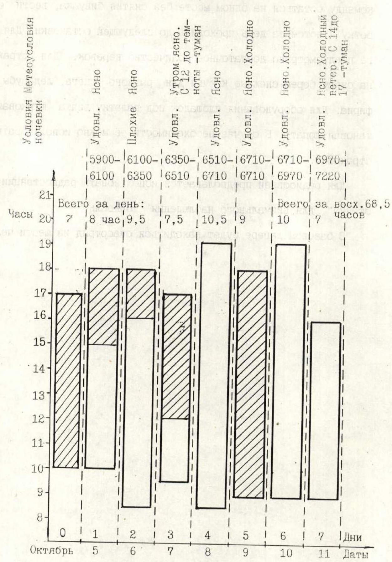
- Team's climbing hours: 68.5 hours, 7 days and 1 day for processing.
- Nights: 1st — 6100 m, lying in a tent. 2nd — 6350 m, semi-reclining in a tent. 3rd — 6510 m, uncomfortable in a tent. 4th–5th — 6710 m, uncomfortable in a tent. 6th — 6970 m, uncomfortable in a tent.
- Team Leader: Pershin Valery Nikolayevich — Master of Sports of International Class
Team Members:
- Vinogradsky Evgeny Mikhailovich — 3rd sports category
- Khabibullin Salavat Zagitovich
- Zhilin Nikolai Fedorovich — Master of Sports
- Ermachek Yuri Vladimirovich — Master of Sports
- Coaches:
- Efimov Sergey Borisovich — 3rd sports category, 3rd sports category of Russia
- Mikhailov Alexander Alexandrovich — Master of Sports, 3rd sports category
- Pershin Valery Nikolayevich — Master of Sports of International Class, team coach
- Approach to the route: October 5, 1995.
Summit: October 11, 1995. Return: October 12, 1995.
- Organization: Sverdlovsk Regional Sports Committee.
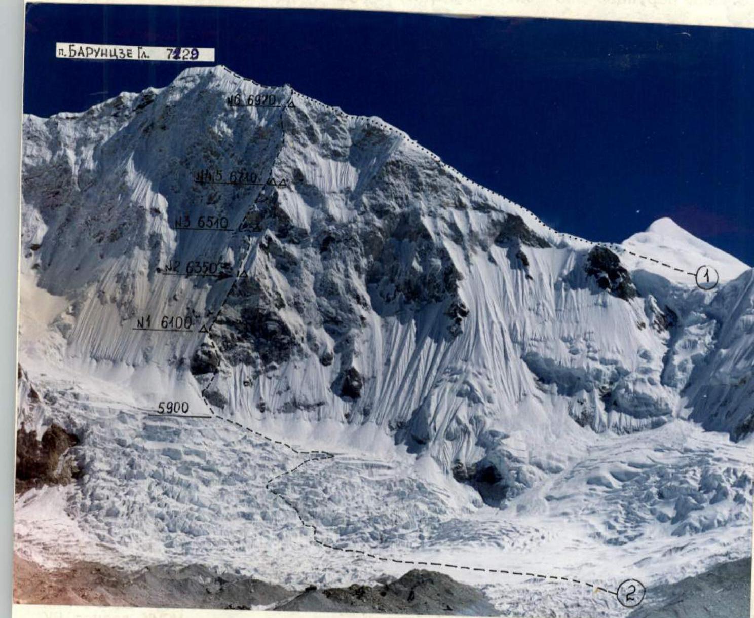
Photo 1. General photo of the summit.
- Path of the first ascenders (E. Hillary)
- Route of the Sverdlovsk Regional Sports Committee team.
Taken from the coastal moraine, H — 5500 m. Shooting point:
- Lens — Helios 44K
- F — 58 mm
- Distance — 3.5 km.
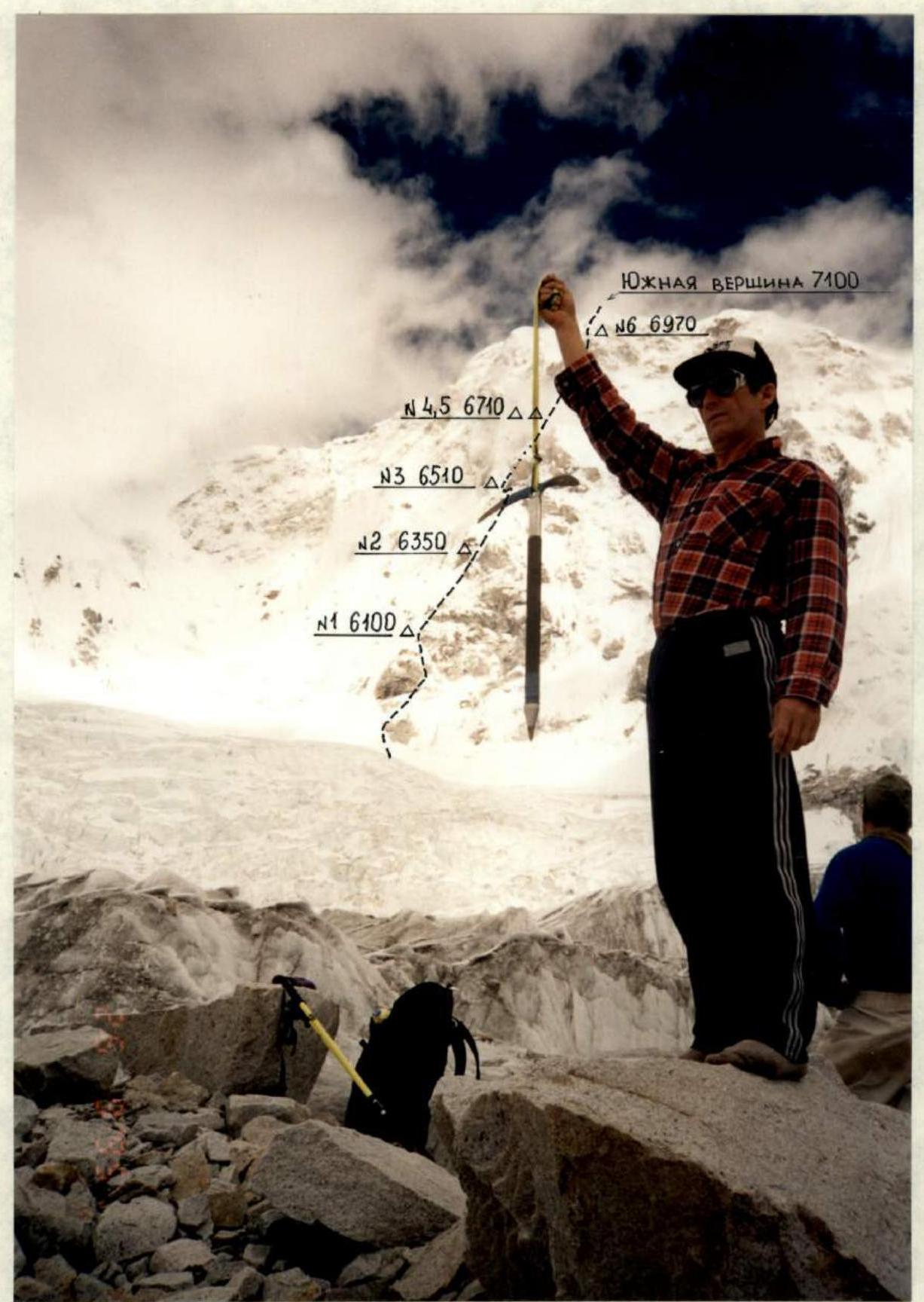
Photo 2. Profile of the wall from the right. Taken from the lateral (left orographic) moraine of the Hongu Glacier. Shooting point No. 2, lens — Yashika Lens, F — 32 mm. October 26, 1995 at 12:30, elevation of the shooting point — 5450 m, distance — 2 km.
Map of the Area
1:50000
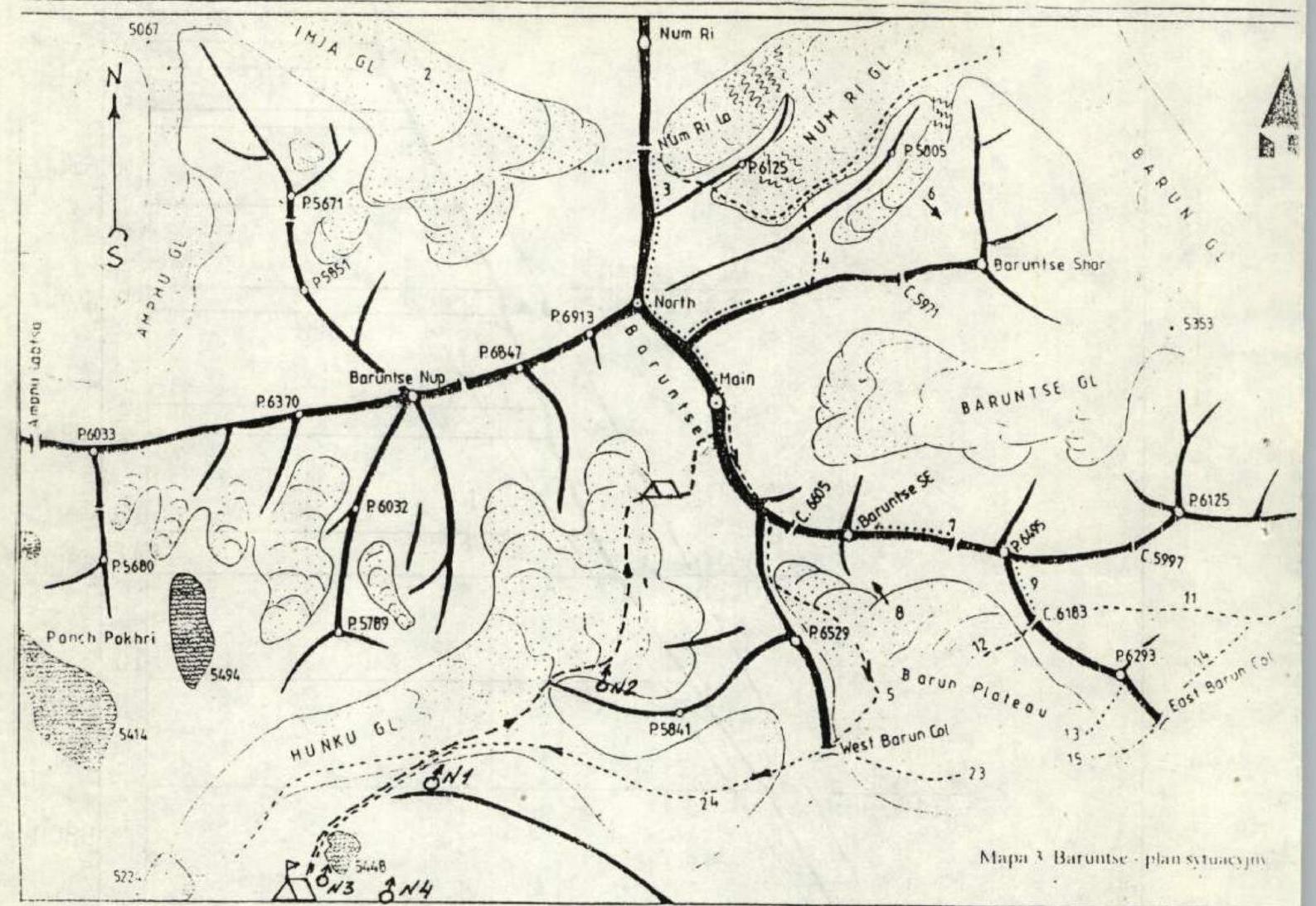
Conventional symbols:
- △ — base camp, observation camp
- Δ — advanced camp
- → — ascent path
- ⋯ → — descent path
- ° — shooting point
Route Profile


Photo 3. Panoramic photo of the area. Taken from the base camp on September 23, 1995. Shooting point 3, lens — Nikon Lens, F — 32 mm. Time 9:00, elevation of the shooting point — 5400 m, distance — 4.5 km.
- 1 — route of the first ascenders (E. Hillary)
- 2 — route of the Sverdlovsk Regional Sports Committee team
Brief Overview of the Climbing Area
The Himalayas — the highest mountains in the world — are a system of giant parallel ranges, located from 73° east longitude in the northwest to 96° east longitude in the southeast. The highest range of the Himalayan mountain system is called the Main Himalayan Range. It stretches from the northwest bend of the Indus to the southeast bend of the Brahmaputra and reaches its maximum height in the Chomolungma massif (8848 m). The southern neighbor of Chomolungma is the Lhotse peak (8501 m). East of the Lhotse massif, at the intersection of the Main Range and the Arun River, stands the fifth highest peak in the world — the monumental Makalu massif (8470 m).
Approximately in the middle of the section of the Main Range connecting Lhotse and Makalu, slightly west of the Petangtse peak (6724 m), a spur extends south from the Main Himalayan Range, in which one of the most beautiful seven-thousanders of the Himalayas — Baruntse peak (7220 m) is located. The first ascent was made by E. Hillary along the South Ridge from the "West Col" pass. The problematic Western wall remained unconquered.
It was chosen by the team of the Sverdlovsk Regional Sports Committee as the object and successfully climbed within the framework of this year's Russian Championship in the high-altitude category.
Cargo delivery and transportation of some expedition members to the base camp (5400 m) under the Western wall were carried out by helicopter from Lukla, trekking to the base camp from Lukla takes eight days.
Preparation for the Ascent
Preliminary familiarization with the object of ascent was done remotely — through literature, photographs, and materials obtained from Germany from the leader of the expedition that visited this area.
When studying the available material and photographs, the central part of the Western wall seemed most attractive. There are two routes to Baruntse peak — along the South Ridge (E. Hillary — first ascent) and along the Northeast Ridge.
The choice of the first wall route was to be made on site after clarifying all the parameters of the Western wall.
Preparation of the team for participation in the Russian Championship began last October. It included:
- general physical and special training;
- cross-country skiing competitions (20 km and 30 km);
- rock climbing (bottom-rope climbing, working in pairs);
- cross-country running, as well as equipment preparation.
In the spring and summer seasons, team members made ascents to:
- Elbrus;
- Khan-Tengri (6995 m);
- Pobeda (7439 m).
In the Himalayas, team members received a gradual acclimatization — 8 days of trekking with a caravan of porters from Lukla to the base camp (5400 m), ascent to the West Pass (West Col) — (6100 m), ascent along the South Ridge to an altitude of 6300 m with two nights.
Before the ascent, observation of the wall was carried out from the base camp, during acclimatization exits, as well as while searching for a path through the icefall to the start of the route. The wall was studied in detail with binoculars, and the following were carried out:
- angle measurements;
- determination of height differences and distances between characteristic points of the route using graphical methods;
- photography of the profile from the right.
It was not possible to take a photo of the profile from the left, as the upper reaches of the Hongu Glacier represent a closed cirque with hanging glaciers.
Based on these data, the route was finally chosen, and a tactical plan was developed.
Observation showed the following:
- The wall has significant icing and the presence of difficult-to-pass and organize protection "Himalayan snows."
- There are many snow cones under the wall; obviously, during snowfall, the wall will "flow."
- Only the base of the counterfort is free from cones.
- To the right of the counterfort, it is dangerous from rockfall in the second half of the day.
- There were concerns about the difficulty of organizing bivouacs, as natural platforms for tents were not visible.
After organizing the path through the icefall, to become more familiar with the wall, especially with the state of steep "Himalayan snows," it was decided to climb the lower part of the counterfort with two pairs before the ascent.
As a result of the work done to study the wall and the state of the snow, the route was finally chosen, a tactical plan for the ascent was developed, and the final selection of equipment was made.
Knowing the average speed of the team's progress on various terrain, it was calculated to complete the route with five nights. One reserve day was planned for bad weather or difficult conditions on steep snow sections of the route.
The lack of platforms may force the team to stay in one place without dismantling the bivouac, process the route, and then cover the distance to the next stop in a day. For this, a sufficient number of ropes were provided.
For protection on snow, they took:
- snow pitons for loose snow;
- ice axes for firn.
For equipping platforms under a tent, a titanium shovel was taken. If necessary, it could be used for protection.
For radio communication, it was planned to use "Lastochka" radio stations, and for visual observation — binoculars.
A rescue team of six people was to be stationed at the base camp.
- Team movement — processing
Tactical Actions of the Team
- Tactical scheme of movement.
The main factors in developing the tactical plan were:
- the combined nature of the terrain with frequent changes in its forms;
- the presence of difficult-to-pass and organize protection very steep "Himalayan snows";
- the lack of natural platforms for tents;
- short daylight hours.
In accordance with this, a tactical plan was developed, providing for nights at 6100 m, 6350 m, 6510 m, 6710 m, and on the "roof," where snow ridges were visible, on which it is possible to organize a platform for a bivouac with further processing of the route from this location if necessary. The following measures are envisaged:
- The possibility of processing the route to a significant height during the ascent (seven ropes were taken) if the state of the terrain or weather conditions require it.
It was decided to climb the route with interaction between pairs, the lead climber without a backpack. All team members worked on a double rope. Visual and radio communication between the team and the base camp. Descent from the summit along the South Ridge (Hillary's path) to the West Col pass and then to the base camp.
- Tactical actions of the team.
The team's movement on the route was carried out in accordance with the tactical plan. Due to the difficult conditions for passing snows in sections R17–R21 and the lack of sufficiently powerful snow ridges for organizing a platform for the night, one reserve day was used.
Throughout the route, the interaction of pairs was used. The first climber moved with protection on a double rope (one UIAA), the rest followed the fixed rope with top-rope protection on jammers without pulling up backpacks.
The good technical preparation of all participants in the ascent allowed for regular changes of the lead climber. By sections, this happened as follows:
- Pershin: R1–R4, R11–R14
- Khabibullin: R5–R8, R16–R21, R23–R24
- Zhilin: R9–R10, R15–R16, R22
- Ermachek: R25
Simultaneous evening processing of the route with preparation of overnight locations, changing the lead climber during the day, and changing pairs every day, as well as hot meals twice a day — all this made it possible to maintain speed in the conditions of a complex Himalayan route, restore strength, and ensure the necessary safety of the ascent.
The team had a first-aid kit with a sufficient supply of medications, two gas burners, gas in sufficient quantity, and a reliable high-altitude "Kanchenjunga" tent. Radio communication was stable throughout the days. An additional power unit was taken. For lunch, each team member had dry rations and a flask with tea. Equipping overnight locations required significant labor costs (at least 2–2.5 hours), which, however, were compensated by full-fledged rest.
The route was completed in accordance with the time schedule of the tactical plan with a large margin of safety, without failures or illnesses, which was due to:
- the many years of experience of all participants in high-altitude ascents;
- their high technical, physical, and psychological preparation.
Route Diagram in UIAA Symbols
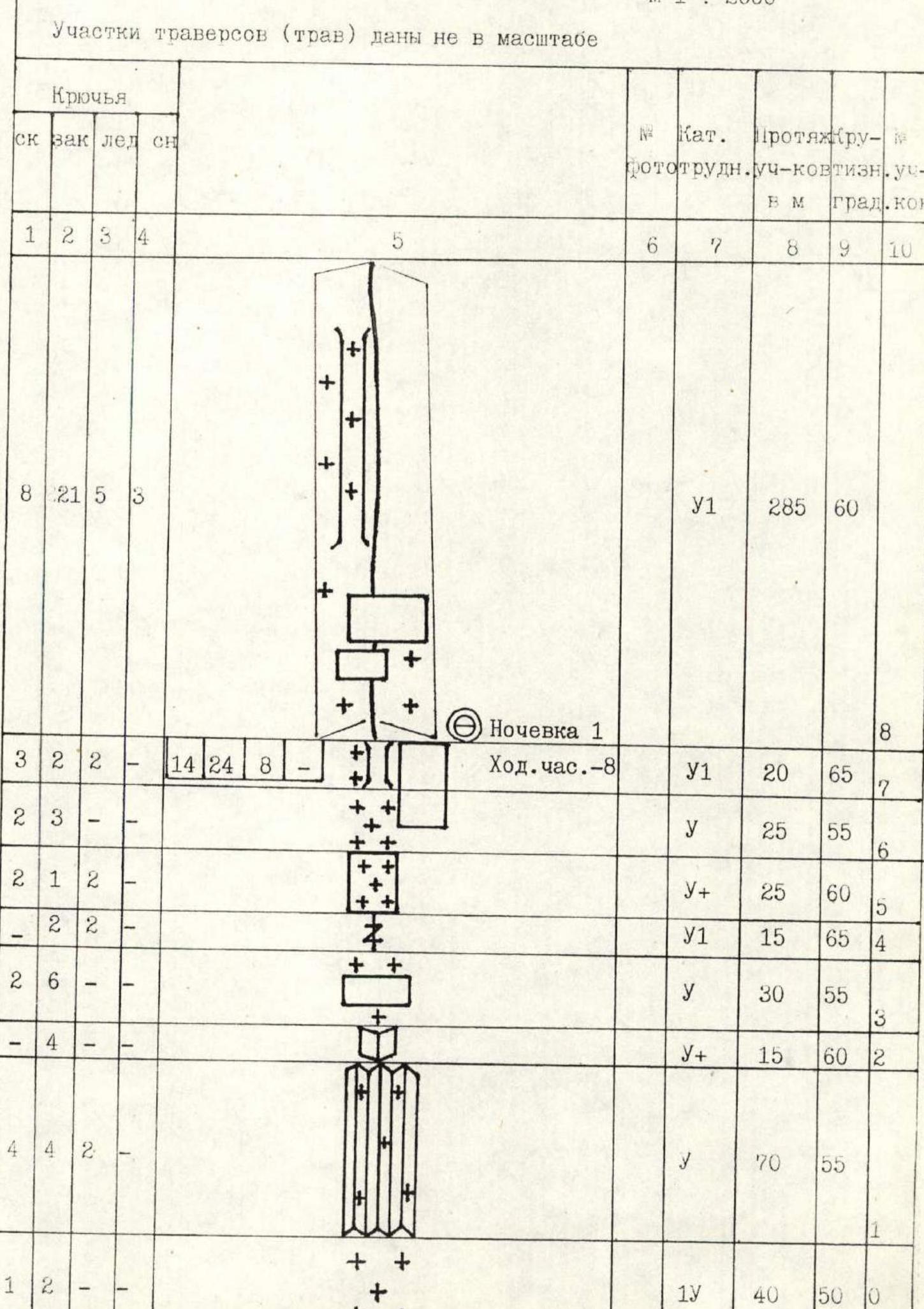
Traverse sections (trav) are not to scale
| Pitons | № | Category of difficulty | Length of sections | Slope of sections | |||||
|---|---|---|---|---|---|---|---|---|---|
| Rock | Chocks | Ice | Snow | m | degrees | ||||
| 1 | 2 | 3 | 4 | 5 | 6 | 7 | 8 | 9 | |
| + | |||||||||
| + | |||||||||
| + | |||||||||
| + | |||||||||
| 8 | 21 | 5 | 3 | + | У1 | 285 | 60 | ||
| + | |||||||||
| + | |||||||||
| + | Night 1 | ||||||||
| 3 | 2 | 2 | + | Climbing hours – 8 | У1 | 20 | 65 | ||
| + | |||||||||
| 2 | 3 | + | У | 25 | 55 | ||||
| ++ | |||||||||
| 2 | 1 | 2 | + | У+ | 25 | 60 | |||
| + | |||||||||
| 2 | 2 | ++ | У1 | 15 | 65 | ||||
| + | |||||||||
| 2 | 6 | ++ | У | 30 | 55 | ||||
| + | |||||||||
| 4 | ++ | У+ | 15 | 60 | |||||
| + | |||||||||
| 4 | 4 | 2 | + | У | 70 | 55 | |||
| ++ | |||||||||
| 1 | 2 | + | IУ | 40 | 50 | ||||
| ++ | |||||||||
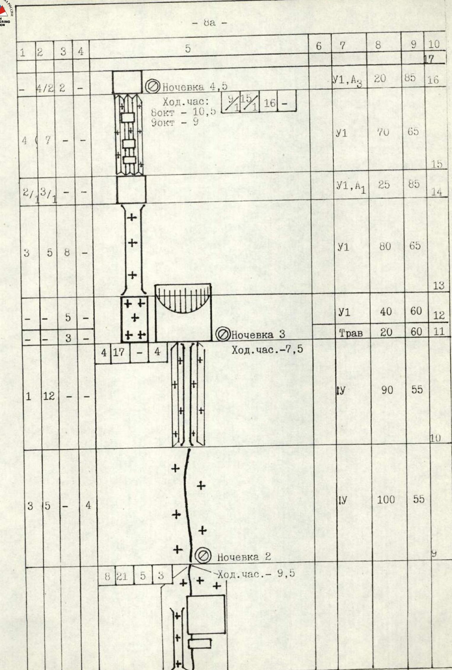
| 4 | 2 | 2 | У1,А3 | 20 | 85 | ||||
| • Night 4–5 | |||||||||
| Climbing hours: | |||||||||
| October 9 | У1 | 70 | 65 | ||||||
| October 10 | |||||||||
| 2 | 3 | 1 | У1,А1 | 25 | 85 | ||||
| У1 | 80 | 65 | |||||||
| У1 | 40 | 60 | |||||||
| • Night 3 | |||||||||
| Climbing hours – 7.5 | Трав | 20 | 60 | ||||||
| IУ | 90 | 55 | |||||||
| IУ | 100 | 55 | |||||||
| • Night 2 | |||||||||
| Climbing hours – 9.5 | |||||||||
| У+ | 150 | 55 | |||||||
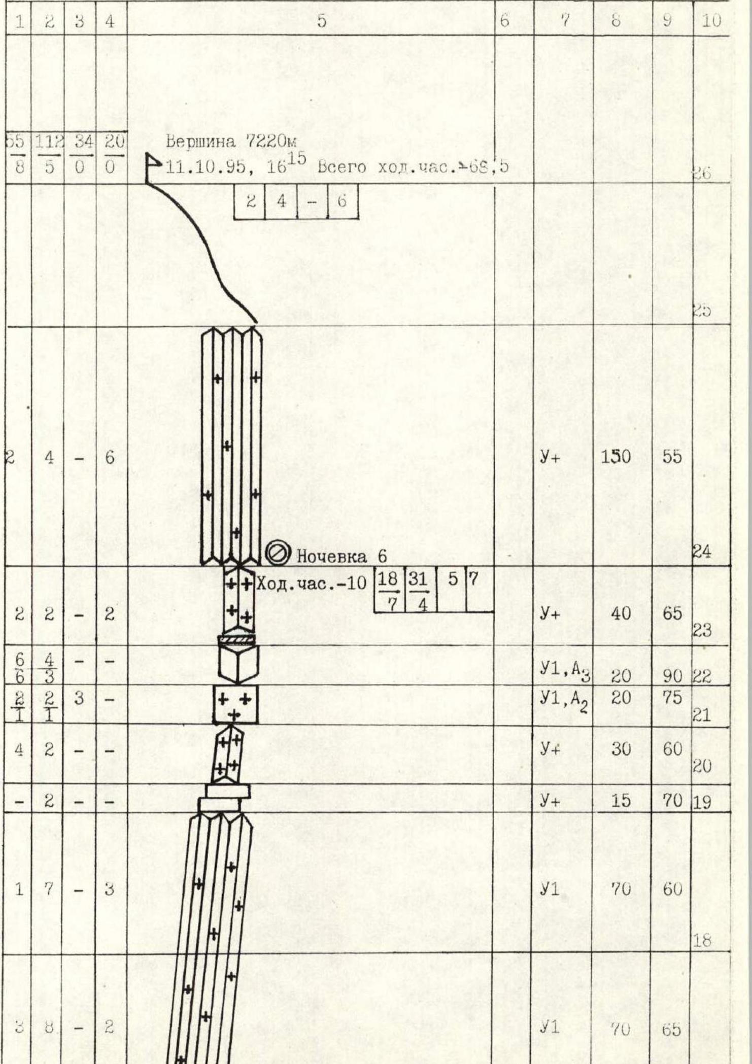
| • Night 6 | |||||||||
| Climbing hours – 10 | У+ | 40 | 65 | ||||||
| У1,А3 | 20 | 90 | |||||||
| У1, А2 | 20 | 75 | |||||||
| У+ | 30 | 60 | |||||||
| У+ | 15 | 70 | |||||||
| У1 | 70 | 60 | |||||||
| У1 | 70 | 65 |
Description of the Route by Sections
Section R0–R1. Firn slope. Bergschrund is overcome along a snow-ice bridge.
Section R1–R2. "Pine tree snows" in combination with tile-like rocks.
"Pine tree snows" — a characteristic snow relief for the Himalayas, representing an alternation of:
- "blade-like" snow ridges;
- gullies.
They can reach great steepness, as at the base of such snows lies a rock wall. Snow is as if plastered onto the wall. Snow ridges are often winding, and their top can be tilted sideways like a cornice. Gullies can have an ice or rock-ice base and be a place where rocks fall from the rocks above. See photos 1, 4, 7, 11, 12.
The state of the snow is coarse-grained, crumbly, and poorly compacted. The term "climbing" on such snows is applicable just like when moving on rocks and ice. Protection is difficult. The team used:
- snow pitons;
- ice axes;
- a shovel.
Note: hereinafter, the term "pine tree snows" refers to the above-described form of mountain relief.
Section R2–R3. Inner corner, the left face overhangs, and the right one — tile-like granite slabs. Protection with the help of friends.
Section R3–R4. Rock outcrops with snow in the direction of an ice-filled vertical crevice.
Section R4–R5. Crevice filled with ice. Movement using ice tools, protection with the help of ice screws and chocks in the side walls.
Section R5–R6. Icy, snow-covered rocks.
Section R6–R7. Snow slope towards a wide gully.
Section R7–R8. Wide gully, the right side of which is formed by monolithic slabs with individual breaks, the bed and left side — accretion ice (photo 5). At the end of the section — night (1).
The presence of a reliable shovel (better an ordinary titanium spade shovel) for organizing nights is simply necessary, as there are no natural platforms on the wall. Hereinafter, platforms were dug out on snow ridges with additional enlargement to the necessary size under a tent by freezing pieces of firn. The time to create a platform under a tent is at least 2 hours.
Section R9–R9. A combination of rock walls, "pine tree snows," wide gullies with accretion ice.
Using the entire arsenal of protective equipment:
- pitons;
- ice screws;
- chocks;
- snow pitons.
See photo 6. Night (2).
Section R14–R15. "Feathers" — steep, rusty, broken rocks, inconvenient for climbing.
Section R15–R16. "Pine tree snows" in combination with rock walls, in which it is possible to organize reliable anchor points. Exit to the base of a nearly vertical rock wall. Nights: (4) and (5) (photo 10).
Section R16–R17. Vertical rock wall requiring a lot of time to organize intermediate anchor points and ITO. Practically no cracks for pitons.
Used:
- eccentric cams;
- ice screws in icy, deep crevices.
Most of the section is climbed on ITO. This is one of the key points of the route.
Sections R17–R19. "Pine tree snows" with the resulting difficulties in organizing protection. Sometimes it is possible to dig down to the rock base and organize reliable piton protection (photos 11, 12).
Section R19–R20. Two steps of icy rocks.
Section R20–R21. Snow-covered rock ridge leading to the pre-summit bastion.
Section R21–R22. Steep rocks filled with accretion ice (photos 13, 14).
Section R22–R23.
- Inner corner with a cornice at the top — very labor-intensive to pass.
- Cracks, as a rule, are blind.
- This and the previous section — key point (2) on the snow ridge.
It was not possible to fully set up the tent, as they hit a rock.
Section R9–R10. Snow ridge.
Section R10–R11. Gully with icy rocks at the base (photo 7). Protection is mainly with the help of chocks. FRIENDs are most applicable. The gully leads to the base of a powerful overhanging bastion. From here, a traverse to the left. At the beginning of the traverse, a snow ridge descends, sufficient to organize a night.
Night (3).
Section R11–R12. Traverse under the rocks of the bastion along steep ice covered with a crust of pockmarked ice (photo 8).
Section R12–R13. Accretion smooth ice bypassing the overhanging bastion. Ice screws after use on this and the next section require sharpening, as the ice contains many small stones (photo 8).
Section R13–R14. Wide gully with granite tile-like slabs covered with a fragile crust of accretion ice. Tense climbing on the front teeth of crampons, as the ice often shatters. Increased requirements for the choice of protection locations, because:
- the fall of ice fragments chipped off by the ice tool is inevitable;
- the fall of ice fragments from a foot strike is also inevitable.
Exit to the ridge (photo 9).
Continuation of the Route Description
Section R23–R24. Snow-covered rocks. Exit to the "roof."
Section R24–R25. "Pine tree snows." The passage of this section is complicated by:
- the lack of reliable piton protection (no rock outcrops or ice);
- the state of the snow (with its great steepness), which raises doubts about its reliability and keeps in great tension.
Exit to the South Summit.
Section R25–R26. Not difficult snow-covered wide ridge. Nevertheless, caution is necessary — the pre-summit part of the ridge and the summit itself have large cornices along the right-hand side. Exit to the Main Summit. Photo 15.
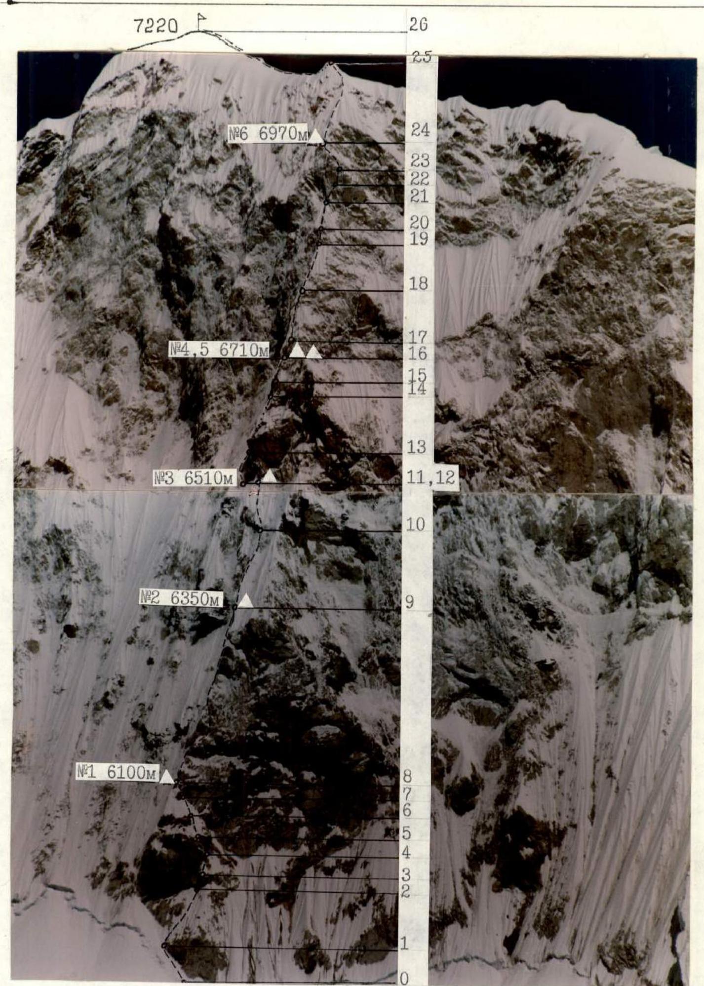
Photo 4. Technical photo of the route. Taken from a nameless peak above the base camp on October 13, 1995. Shooting point: 4, lens — Vivitar, F — 200 mm. Time: 12:00, elevation of the shooting point — 5800 m, distance — 4.5 km.

Photo 5. Section R7–R8. Movement along the fixed rope. Taken on October 5, 1995 at 14:30. Lens — Yashika Lens, F — 32 mm.
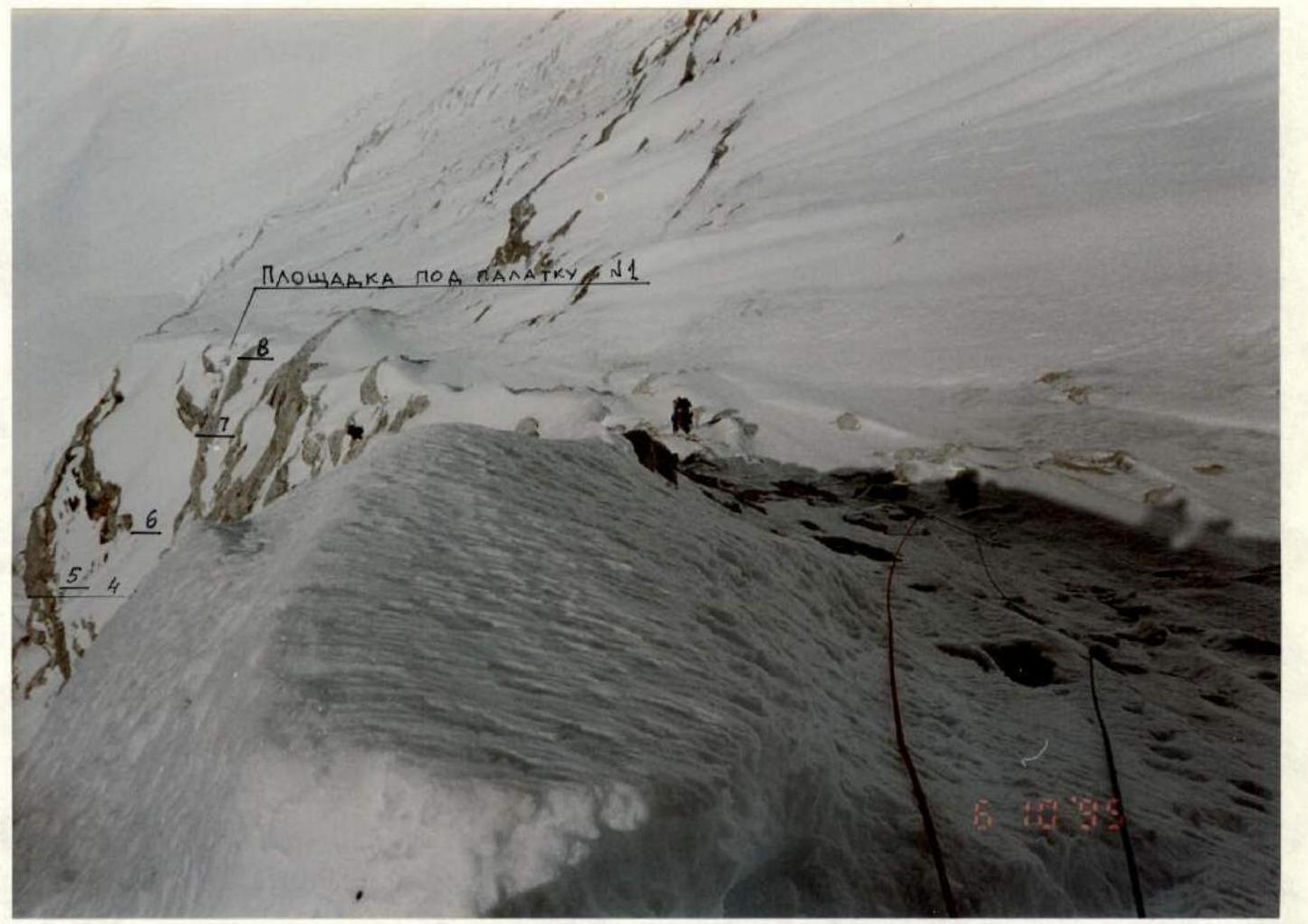
Photo 6. Movement along the fixed rope on section R8–R9. The sections R4–R8 and the platform on night (1) are visible below. Taken on October 6, 1995 at 11:30. Lens — Yashika Lens, F — 32 mm.
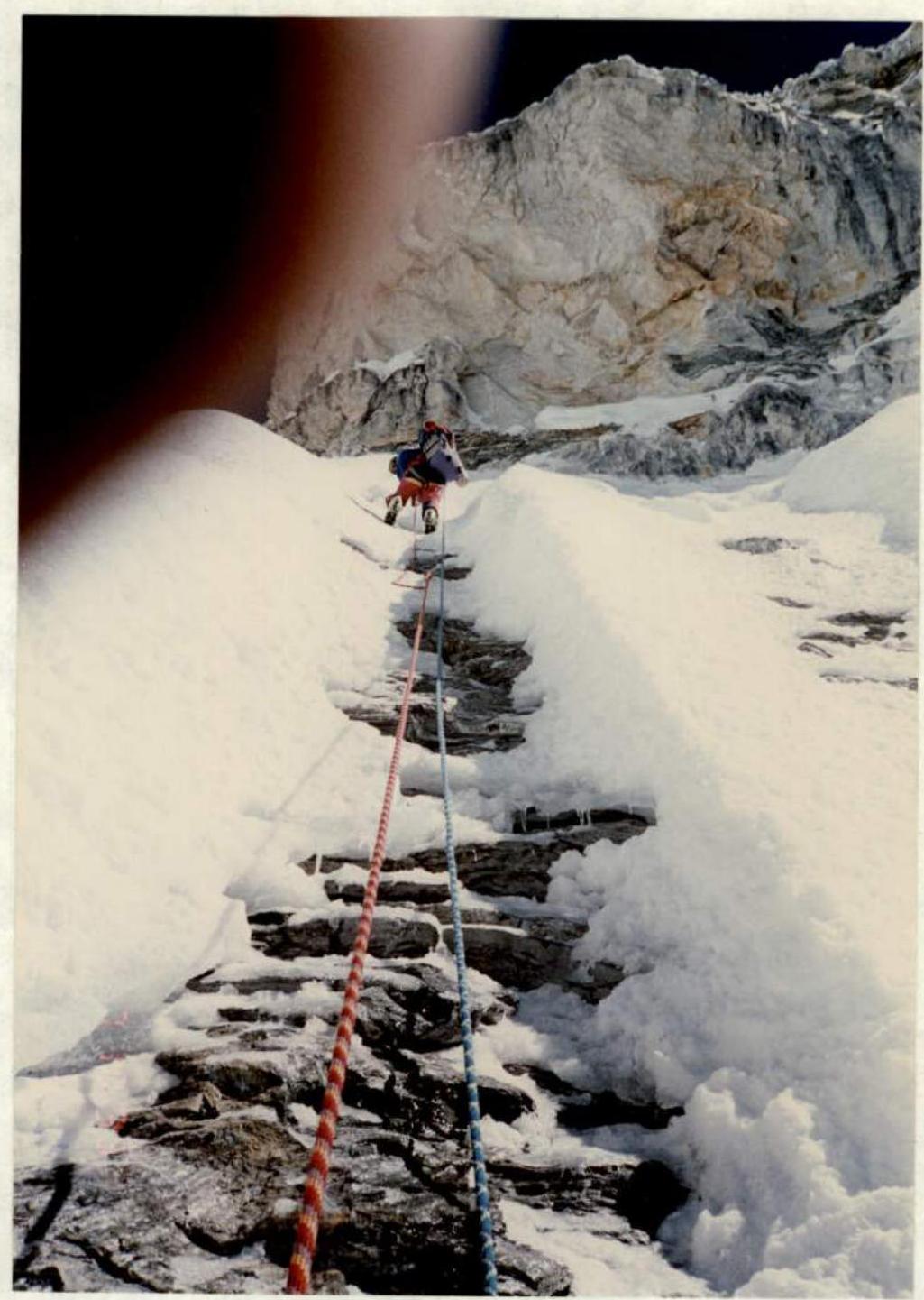
Photo 7. Section R10–R11. Taken on October 7, 1995 at 11:00. Lens — Yashika Lens, F — 32 mm.
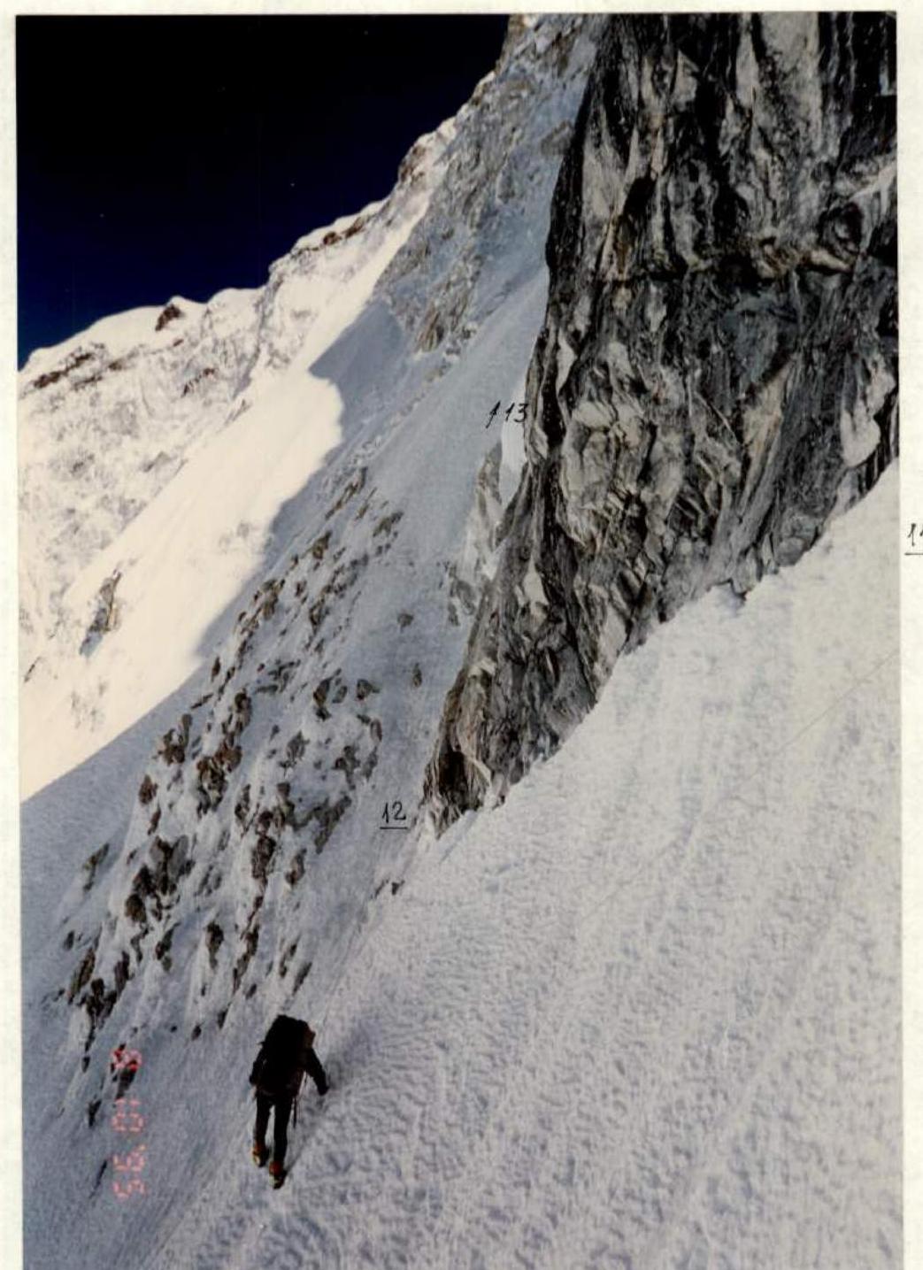
Photo 8. Traverse on section R11–R12. Taken on October 8, 1995 at 9:00. Lens — Yashika Lens, F — 32 mm.
Photo 11. Passage of steep snows on section R18–R19. Taken on October 10, 1995 at 11:00. Lens — Yashika Lens, F — 32 mm.
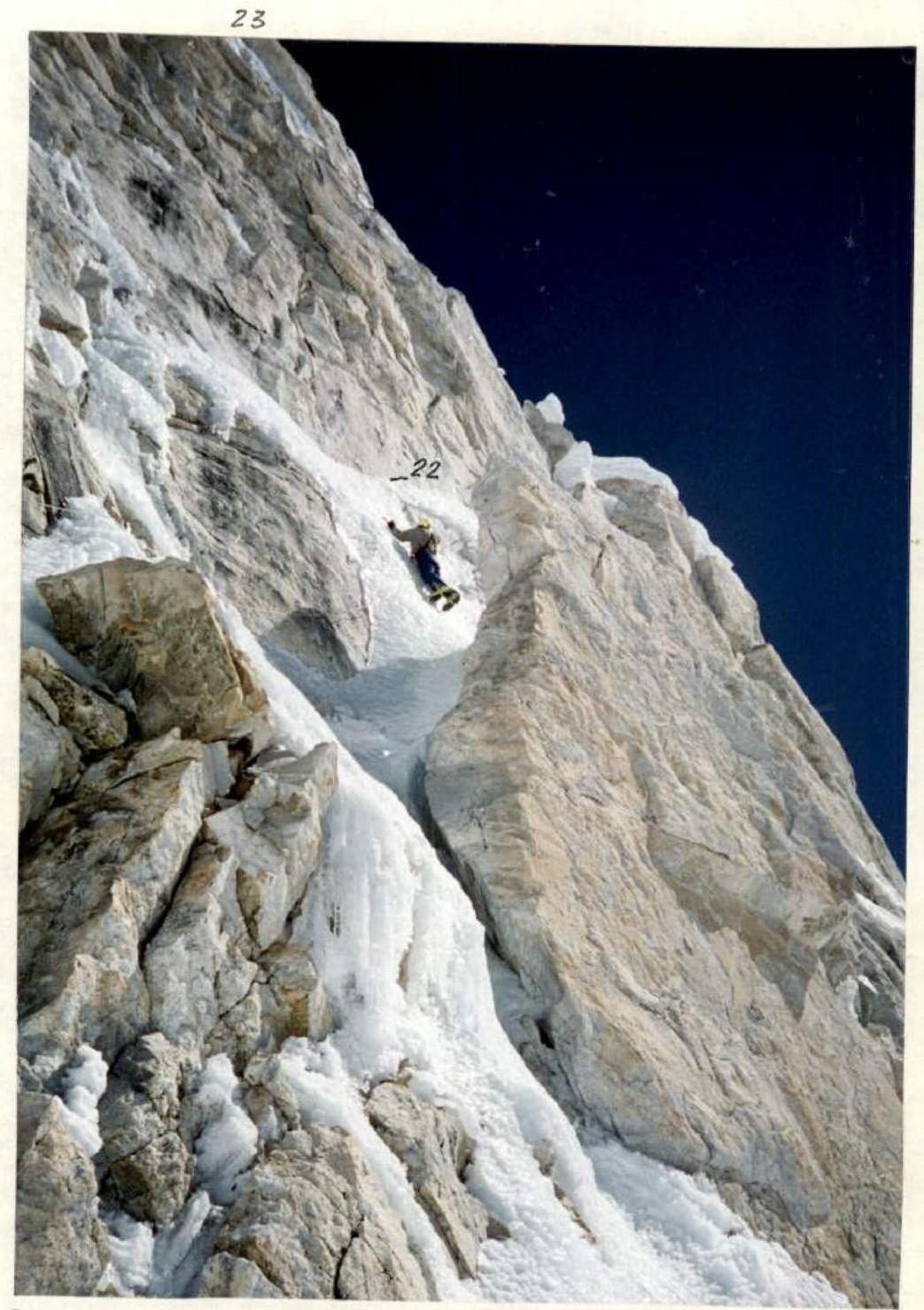
Photo 13. Sections R21–R23. Taken on October 10, 1995 at 13:00. Lens — Yashika Lens, F — 32 mm.